Latest News

NEWS September 2023
September 2023. Hi Atlantipedes, At present I am in Sardinia for a short visit. Later we move to Sicily and Malta. The trip is purely vacational. Unfortunately, I am writing this in a dreadful apartment, sitting on a bed, with access to just one useable socket and a small Notebook. Consequently, I possibly will not […]Read More »
Joining The Dots
I have now published my new book, Joining The Dots, which offers a fresh look at the Atlantis mystery. I have addressed the critical questions of when, where and who, using Plato’s own words, tempered with some critical thinking and a modicum of common sense.Read More »
Dale Huffman
Nygren, Johan
Johan Nygren is the author of a number of papers touching on a number of subjects such as expansion tectonics(b), Cro-Magnons and Atlantis. He brings them all together in an Atlantis theory which places Atlantis in the region of Iceland(a). He believes that Cro-Magnon man lived in Atlantis(c). However, in another paper, he claims that Greenland looks like the map of Atlantis created by Athanasius Kircher(e), a suggestion put forward some years ago by Dale Huffman.
When Nygren first wrote about Atlantis, in an article now removed from the internet(d). he was sure that it could be identified as South America,
He also proposes that Atlantis produced the beginnings of civilisation.
(a) https://steemit.com/atlantis/@johan-nygren/iceland-as-atlantis-2-0
(d) Having discovered the myth of Atlantis in the past days, I’ve now conformed to that it described South America (“Isla Atlantica”) — SteemKR (archive.org) (link broken)
Kircher, Athanasius *
 Fr. Athanasius Kircher (1602-1680) was a German Jesuit scholar and a professor of ethics and mathematics at the University of Würzburg. In his day he was considered one of the greatest authorities in Europe on Chinese and Egyptian cultures, archaeology, ancient languages and astronomy. However, he was not without his detractors, one of whom was Descartes who robustly attacked Kircher’s scientific abilities. Kircher’s writings filled 44 folio volumes.
Kircher claimed to have deciphered the ancient Egyptian hieroglyphics, but this was later shown to be unfounded and drew highly critical comments such as that of the Egyptologist Sir E. A. Wallis Budge who wrote in 1910: Many writers pretended to have found the key to the hieroglyphics, and many more professed, with a shameless impudence which is hard to understand in these days, to translate the contents of the texts into a modern tongue. Foremost among such pretenders must be mentioned Athanasius Kircher, who, in the 17th century, declared that he had found the key to the hieroglyphic inscriptions; the translations which he prints in his Oedipus Aegyptiacus are utter nonsense, but as they were put forth in a learned tongue many people at the time believed they were correct. A more recent critique is available online(b).
When it is realised that more than a century was to pass after Kircher’s death before the Rosetta Stone was discovered and the work of Champollion finally gave us a reliable decipherment of Egyptian hieroglyphics, it is quite reasonable to treat Kircher’s translation as purely speculative. His efforts in this regard were recently described as ‘illusory’.
In recent times Kircher has regained widespread fame because of the map, published in his Mundus  Subterraneus [1203], which among a range of subjects(c), outlines Atlantis (Insula Atlantis) between Africa and America. This Latin text can now be read or downloaded online(a). A 1678 edition of the book held in the Fagel Collection in Trinity College, Dublin has been described as one of the most beautiful books in the collection(h).
In Mundus Subterraneus Kircher was the first to propose that the Canaries and the Azores were the mountain peaks of sunken Atlantis. His famous map has the north shown at the bottom with Africa and Spain on the left and America on the right. There is no particular significance in this fact as the convention of having North at the top of maps is relatively recent and generally attributed to the controversial 8th-century Irish cleric, Virgil of Salzburg, who was eventually appointed bishop of that city and later canonised as St. Virgilius. A Latin label on the map reads: “site of Atlantis, now beneath the sea, according to the beliefs of the Egyptians and the description of Plato. A chart based on beliefs and descriptions clearly shows that his offering is speculative and not a real map, although some claim that it is an ‘authentic’ depiction of Atlantis, such as can be seen on an hour-long YouTube video from a 1997 conference(g).
>Despite being based on speculation, Kircher’s map is still widely used today. An article by Phil Edwards has commented on its continued use – ” We can only guess why one map became the iconic depiction of Atlantis, but there are a few reasonable assumptions. It had a veneer of scientific legitimacy, thanks to Kircher’s reputation and other work. It came at a time when the world was actively being reimagined. And Kircher’s map was one of the earliest ones nestled into an otherwise accurate depiction of the world. And perhaps most important is that once Atlantis’s appearance was established it couldn’t really be disproven. So the same map stuck around for centuries” (l).<
Recently, Doug Fisher has drawn attention to the similarities between a 1592 map of South America by Abraham Ortelius and Kircher’s Atlantis map when inverted(e). Frank Jacobs has highlighted the same comparison but also notes how the map might be seen as an image of Greenland(i). Some further background information on Kircher’s map is to be found online(f).
Kircher’s Atlantis map is widely used, particularly by supporters of an Atlantic Atlantis. Some, such as Dieter Thom, have followed Kircher’s view that Atlantis had been located in the Azores, while others have been more liberal in their interpretation of the map. Dale Huffman, Johan Nygren and Mario Dantas have associated the map with Greenland. Ian A. Fox has pushed matters further by nominating Baffin Bay west of Greenland as formerly the Plain of Atlantis. Now, while all these have kept their chosen Atlantis locations within the Atlantic Ocean conforming, at least to some extent, with Kircher’s map. However, there are a number of commentators who have employed the map to justify even more exotic locations. At one end of the world, Rand and Rose Flem-Ath were apparently inspired by Kircher’s map and opted for an Antarctic Atlantis, while at the other end, just south of the Arctic Circle Marco Francesco Bulloni has nominated the Solovetsky archipelago in northwest Russia as the home of Atlantis, once again inspired by Kircher. Of course, I’ve saved the best for last with Australia as the nominee and a specific location of Port Arthur in Tasmania(k).
Less known is his 1665 world map recently published on the atlan.org. website(j).
![]()
In 2004 a book[425] with the enticing title of Athanasius Kircher: The Last Man Who Knew Everything was published. It was edited by Paula Findlen and includes essays by leading historians of our day.
(a) https://archive.org/details/mundussubterrane02kirc
(b) https://publicdomainreview.org/2013/05/16/athanasius-kircher-and-the-hieroglyphic-sphinx/
(c) https://publicdomainreview.org/2012/11/01/athanasius-underground/
(e) https://atlantismaps.com/chapter_7.html (Link broken Nov. 2018) New replacement site is now being developed – https://www.copheetheory.com/
(f) https://www.vox.com/2015/4/30/8516829/imaginary-island-atlantis-map-kircher
(g) https://www.youtube.com/watch?v=DZcuJKilUdw
(h) https://www.tcd.ie/library/fagel/ *
(i) Could South America be Atlantis? – Big Think
(j) The World Map of Athanasius Kircher 1665. – Atlan.org
(k) The location of Atlantis, page 1 (archive.org) (The map was not saved by Wayback Machine)
(l) https://www.vox.com/2015/4/30/8516829/imaginary-island-atlantis-map-kircher
Greenland
Greenland was first proposed as the location of Atlantis in the 17th century by François de la Mothe le Vayer. More recently some of the more imaginative writers have tried, unsuccessfully, to revive interest in 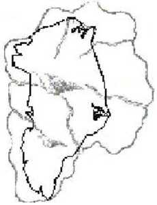 this idea. One of these is the American, Dale Huffman, who claims that the outline of Greenland is comparable with Kircher‘s famous map of Atlantis. He has also proposed that while Atlantis primarily consisted of Greenland it also included “the islands of the United Kingdom and Iceland”(h). Huffman ignores the fact that Kircher’s map clearly places Atlantis between the Strait of Gibraltar and America, not between Canada and Scandinavia. Apart from this, Kircher favoured the Azores and Canaries as the remnants of Atlantis.
Another proponent is Mario Dantas who is equally determined to link Plato’s description with the enormous island of Greenland(a) and has submitted a paper on the subject to the 2008 Atlantis Conference in Athens.
More recently Johan Nygren drew attention to the similarities between a map of Greenland and the 17th-century map of Atlantis produced by Athanasius Kircher(m).
>Before that, Riaan Booysen commented on Mercator’s treatment of the Arctic region on his 1569 world map as developed by his son “Virtually all the medieval maps of the Arctic region depict Greenland as free of ice. In order to see if there might be a correlation between Mercator’s transposed map of Greenland and an ice free Greenland, the latter has to be compared to a bedrock elevation map of Greenland. This is done in Figure 30 (see link), which shows an arguably marked correlation between the two maps. If true, it would prove, like the ice free maps of Terra Australis, not only that an ancient, prehistoric map-making civilization once existed, but also that the ice core dating technique is fundamentally flawed, or at least, the interpretation of the ice core data.”. (n)<
Another website(b) advocates the Baffin Basin just west of Greenland, as the Great Plain of Atlantis. This idea developed by a New Zealander, Ian Fox, is based on a reinterpretation of Plato’s text combined with the studies of Charles Hapgood.
In 2014, Antonio Usai published an English translation of his 2011 booklet on the Pillars of Hercules[980] in which he places the original ‘Pillars’ on the Tunisian island of Kerkennah and then unexpectedly proposed that Atlantis was situated in Greenland.
Another proponent of the Greenland location is Stefan Grossmann in his book, Atlantlantean(sic) Philosophy(d), a commentary on the non-existent ‘Emerald Tablets of Thoth’(e), concocted by Maurice Doreal (Claude Doggins).
In October 2011 a team of researchers from the Laboratory of Geology in Lyon may have elevated the importance of Greenland to an even higher level with their claim(c) that life on earth may have originated there 3.8 billion years ago.
In 2013, Lucio Russo, an Italian mathematician and science historian, located Thule on the coast of Greenland, having identified errors in Ptolemy’s geographical calculations[1060].
In 2014 Antonio Moreno Checa published La Atlántida. El mito hecho realidad (Atlantis. The myth comes true) [1063] in which he also locates Atlantis in Greenland. Gennaro Anziano, an Italian writer, has also located Atlantis in Greenland(g) in his 2001 book, Atlantis – Discover the land of the gods[1072].
David Chase Taylor, journalist and conspiracy theorist, published, Greenland Theory: Apocalypse Now, which placed Atlantis in Greenland. However, he is more concerned with the location of the CIA, which he continually repeats has its headquarters under CERN in Switzerland(j)!!! An April 2020 review gives a flavour of the wide-ranging nonsense to be found within this book(k), with little to advance our knowledge of Atlantis.
Marco Goti published The Island of Plato[1430] in 2017 and offered another failed attempt at identifying Greenland as Atlantis.
Leaving aside any suggested connection with Atlantis, there are other features of the vast island that deserve attention. There are a number of raised beaches that clearly indicate that “the whole of this large island has been raised, or the sea has sunk, in post-glacial times” and that “the upheaval has been greater in the north”. Their height above sea level varies from 325 and 480 feet!
In 2018 a huge impact crater was discovered under Greenland’s Hiawatha Glacier. It was initially thought that this impact had been the cause of the Younger Dryas cooling 12,000 years ago, but this idea has now been discounted as the crater is now thought to be 58 million years old.
(a) https://www.a7lan7is.blogspot.com/
(b) https://www.angelfire.com/film/atlantis_1/Page001.html
(e) https://www.jasoncolavito.com/blog/the-emerald-tablets-of-thoth-a-lovecraftian-plagiarism
(g) Svelato il mistero delle Piramidi (archive.org)
(i) Greenland – Raised Beaches – I | MalagaBay (archive.org)
(j) https://archive.org/details/GreenlandTheory/mode/2up
(k) https://americanloons.blogspot.com/2020/04/2324-david-chase-taylor.html