Latest News

NEWS September 2023
September 2023. Hi Atlantipedes, At present I am in Sardinia for a short visit. Later we move to Sicily and Malta. The trip is purely vacational. Unfortunately, I am writing this in a dreadful apartment, sitting on a bed, with access to just one useable socket and a small Notebook. Consequently, I possibly will not […]Read More »
Joining The Dots
I have now published my new book, Joining The Dots, which offers a fresh look at the Atlantis mystery. I have addressed the critical questions of when, where and who, using Plato’s own words, tempered with some critical thinking and a modicum of common sense.Read More »
Dieter Braasch
Pillars of Herakles
Pillars of Heracles, when Googled, will offer nearly 100,000 results, with Wikipedia and Britannica usually heading the list.
Wikipedia says “The Pillars of Hercules was the phrase that was applied in Antiquity to the promontories that flank the entrance to the Strait of Gibraltar. The northern Pillar, Calpe Mons, is the Rock of Gibraltar. A corresponding North African peak not being predominant, the identity of the southern Pillar, Abila Mons, has been disputed throughout history, with the two most likely candidates being Monte Hacho in Ceuta and Jebel Musa in Morocco.”
Britannica says “Pillars of Heracles, also called Pillars of Hercules, two promontories at the eastern end of the Strait of Gibraltar. The northern pillar is the Rock of Gibraltar at Gibraltar, and the southern pillar has been identified as one of two peaks: Jebel Moussa (Musa), in Morocco, or Mount Hacho (held by Spain), near the city of Ceuta (the Spanish exclave on the Moroccan coast).”
Although these two popular sources substantially agree with each other, the concurrence is misleading. In fact, various aspects of the Pillars have been the subject of controversy for a very, very long time.
CONFUSION
The Pillars of Heracles (PoH) according to conventional wisdom were always situated somewhere in the vicinity of the Strait of Gibraltar. However, the truth is rather different. The question of the location of the Pillars has led to confusion and controversy for millennia. A flavour of this was contained in William Smith’s still highly-regarded Dictionary of Greek and Roman Geography [1719] of 1854, which lists many of the locations proposed by ancient authors. One short paragraph in it encapsulates the confusion that has existed in the past and still does, although seldom highlighted, today – ” But when the ancient writers began to investigate the matter more closely, they were greatly divided in opinion as to where the Pillars were to be sought, what they were, and why they were called by the name of Hercules.”(w)
When I began my study of the Pillars, it became obvious very early on that the subject was more complicated than usually presented. Frankly, I never expected to end up as bewildered as I did. First of all, I find that some of the ancient writers have not only referred to two pillars but even three(x) and four of them.
HERAKLES
That was bad enough, but when I was then confronted with a multiplicity of mythical heroes named Herakles, numbering three (Diodorus), four (Servius), six Cicero, seven (Herodotus)(ap(z), and a prize-winning forty-four by Varro, I was even more perplexed.
Ariadna Arriaza published a paper about the multiplicity of Herakles’ in ancient texts, particularly Herodotus(z), who offered at least seven! William Smith’s Dictionary noted that “Herodotus tells us that the original Heracles hailed from Egypt and says that according to the Egyptian tradition, Heracles was one of twelve deities descended from the original eight gods who created the universe (2.43-5). Diodorus claimed that when Osiris went to accomplish his labors he left the government of Egypt in the hands of this primordial Heracles. Remarkably, Pausanias, Tacitus, and Macrobius all confirm that Heracles hailed from Egypt [1729.401]”
John K. Lundwall noted the profusion of Herakles’ [1747] and also refers to the Phoenician Herakles – Melqart and its possible influence on the development of the Greek myth. He concluded that ” Heracles was not invented by the Greeks. He was inherited by the Greeks. Half of his labors descend from Mycenaean or Minoan times, implicating a Heracles-like figure with a series of labors in the days before Greece was founded. Gilgamesh is a Near Eastern Heracles.”
Apart from the Canaanite Melqart(ak) and the biblical Samson, Herakles was also associated with Briareus or Cronos. Aelian, in his Varia Historia 5.3, noted that “Aristotle affirms that those Pillars which are now called of Hercules, were first called the Pillars of Briareus.”
Herodotus visited the temple of Heracles in Tyre with two pillars, one of gold and the other emerald. According to the priests there, it had stood for two thousand three hundred years or from approximately 2700 BC. Another suggestion has been that the ‘Pillars Heracles’ was a Greek rendering of the Egyptian ‘Pillars of Osiris’.(t)
So not only do we have a number of Heracles but also a variety of names for them.
THE NATURE OF THE PILLARS
My confusion was further compounded by the term stelai used by Plato to describe the Pillars, which is the Greek word for stone or wooden slabs used as boundary or commemorative markers, not a reference to supportive columns. I must emphasise that Plato referred to stelai, not mountains.
Rhys Carpenter favoured the idea that the term when applied to the Strait of Gibraltar was used with the sense of boundary markers, indicating ”the limits of the Inner Sea that, for the Greeks, was the navigable world” [221.156]. It is reasonable to suggest that as the Greeks became more expansionist with their trade and colonisation, new limits were set as they moved incrementally westward along with the appellation of the ‘Pillars of Hercules’.
One advocate of this idea, Thorwald C. Franke maintains that the westward shift of the ‘Pillars’ from the Strait of Messina towards Gibraltar occurred a century before Solon. He expanded on this at the 2008 Atlantis Conference [0750.170] and in his 2006 book on Herodotus [0300].
Further difficulties were provided by early authors describing the Pillars as mountains, statues, islands or promontories! Egerton Sykes was convinced that the Pillars had been two menhirs, 30ft tall that had stood on top of the Rock of Gibraltar(u)! In this regard, it is interesting that Jürgen Spanuth dismissed those who have identified the red and white cliffs of Heligoland as the Pillars of Heracles, decrying the idea as a fallacy [015.100]. He explained that “Natural rock formations were not what was originally meant by the Pillars of Heracles. Those at the Straits of Gibraltar were not, as one so often reads, the rocks to the north and south of the Straits, but two man-made pillars which stood before the temple of Heracles at Gades (present-day Cádiz) about 100 km north of the Straits.” Spanuth also denied that the Straits of Gibraltar were ever closed [p248].
Some of the earliest references to the Pillars of Heracles come from Pindar, who seems to have used the term as a metaphor for the limits of human capabilities, be it in sport or more usually, geographical boundaries. So as the Greeks gradually extended the range of their maritime capabilities, new boundaries were established and designated as the new Pillars of Heracles. If there had been a Metaxa Book of Records at that time it would have frequently updated the location of the ‘Pillars’.
Totally unrelated to Atlantis is the natural formation on Antigua known as the so-called Pillars of Hercules(bd).
PHOENICIAN PILLARS
Gades was originally named Gadir (walled city) and is thought to have been founded by the Phoenicians around 1100 BC and Carthage circa 814 BC, although there are question marks around both dates.(ao)
Strabo wrote; “Concerning the foundation of Gades, the Gaditanians report that a certain oracle commanded the Tyrians to found a colony by the Pillars of Hercules. Those who were sent out for the purpose of exploring, when they had arrived at the strait by Calpe, imagined that the capes which form the strait were the boundaries of the habitable earth, as well as of the expedition of Hercules, and consequently, they were what the oracle termed the Pillars. They landed on the inside of the straits, at a place where the city of the Exitani now stands. Here they offered sacrifices, which however not being favourable, they returned. After a time others were sent, who advanced about 1500 stadia beyond the strait, to an island consecrated to Hercules, and lying opposite to Onoba, a city of Iberia: considering that here were the Pillars, they sacrificed to the god, but the sacrifices being again unfavourable, they returned home. In the third voyage, they reached Gades and founded the temple in the eastern part of the island, and the city in the west. (3.5.5.) If this story has any historical basis, the first Phoenician visits to the vicinity of Gibraltar must have taken place before 1100 BC.
Heracles is the Greek counterpart of the Phoenician god Melqart, who was the principal god of the Phoenician city of Tyre. Melqart was brought to the most successful Tyrian colony, Carthage and subsequently further west, where at least three temples dedicated to Melqart have been identified in ancient Spain, Gades, Ebusus, and Carthago Nova. Across the Strait in Morocco, the ancient Phoenician city of Lixus also had a temple dedicated to Melqart.
Pairs of free-standing columns were important in Phoenician temples and are also to be found in Egyptian temples, as well as being part of Solomon’s temple (built by Phoenician craftsmen). Consequently, the pillars of Melqart temple in Gades are considered by some to be the origin of the reference to the Pillars of Melqart and later of Heracles (by the Greeks) and Hercules (by the Romans) as applied to the Strait of Gibraltar.
Greek colonisation by individual city-states got underway early in the first millennium BC. This expansion of trade and territory took place gradually during the eighth, seventh and sixth centuries BC. The online Ancient History Encyclopedia website noted that “One of the most important consequences of this process, in broad terms, was that the movement of goods, people, art, and ideas in this period spread the Greek way of life far and wide to Spain, France, Italy, the Adriatic, the Black Sea, and North Africa. In total then, the Greeks established some 500 colonies which involved up to 60,000 Greek citizen colonists, so that by 500 BCE these new territories would eventually account for 40% of all Greeks in the Hellenic World.”(aq)
While the AHE offers an excellent overview of Greek colonisation, a valuable and more detailed study is also available online(ar), namely, The Expansion of the Greek World, Eighth to Sixth Centuries B.C. [1752], edited by Boardman & Hammond.
LOCATION, ACCORDING TO CLASSICAL AUTHORS
Classical writers frequently refer to the ‘Pillars’ without being in any way specific regarding their location. It always seemed to me that when the Greeks began their Mediterranean trade expansion and colonisation outside the Aegean, apart from the Pentapolis of Cyrenaica in the far south and some possible trading posts in the Levant, they did so exploiting the northern shores of the Mediterranean. Understandably, they would have taken the shortest route from the Greek mainland to the heel of Italy and later on to Sicily. As this development progressed, new limits were set, and in time, exceeded. I suggest that these limits were each in turn designated the ‘Pillars of Heracles’ as they expanded further. I speculate that Capo Colonna (Cape of the Column) in Calabria(as), in South Italy, may have been one of those early boundaries. Interestingly, 18th-century maps display up to five islands near the cape, which are no longer shown on charts(at). This appeared on respected atlases as late as 1860. According to Armin Wolf, these were originally added to maps by Ortelius, inspired by some earlier cartographers and the comments of Pseudo-Skylax and Pliny(au)!
Homer did not use the term Pillars of Heracles, although he does refer to the Pillars of Atlas (Odysseus 1.51-4).
Hecataeus (550-476 BC), according to Oliver D. Smith in a 2019 paper(y), placed the PoH at Mastia, which is thought to be Cartagena in southeastern Spain. This identification is principally based on the early 20th-century studies of Adolf Schulten.
Scylax of Caryanda (late 6th & early 5th cent. BC) describes in his Periplus(a), a guide to the Mediterranean, that the Maltese Islands lay to the east of the Pillars of Heracles. This would place the archipelago east of the Gulf of Gabes, which is compatible with the opinions of Hofmann and Sarantitis. Anton Mifsud argues that had the Pillars been located at Gibraltar, the islands to the east would have been the Balearics, which was certainly true for the ancient Greek shore-hugging mariners.
Pindar (518-438 BC) would appear to have considered that the phrase ‘Pillars of Herakles’ was a metaphor for the limits of physical prowess as well-established Greek geographical knowledge (Olympian 3.43-45), a boundary that was never static for long. In 1778, Jean-Silvain Bailly was certain that the Pillars of Hercules were just “a name that denotes limits or boundaries.” [0926.2.293] More recently Professor Dag Øistein Endsjø, at the University of Oslo in Norway, has endorsed the idea that the ancient Greeks used the ‘Pillars of Heracles’ as a metaphor to express the limits of human endeavour(d) and quotes the classicist, James S. Romm in support(e). In a sentence, the Pillars advanced along with extended geographical certainty.
When the Greek expansion westward in the Mediterranean began to gather pace, no location remained long enough as the new limit of Greek influence to enable it to acquire any permanent recognition as the metaphorical Pillars of Herakles. However, when they reached the western end of the Mediterranean and were blocked by the Phoenicians, this region offered the final resting place of the ‘Pillars’, which retains the title today.
Isocrates (436-338 BC) was an ancient Greek rhetorician and a contemporary of Plato. He wrote of Herakles setting up Pillars near Troy as a boundary marker, following the Trojan War (To Philip 5.112)(bi)(bj).
Aristotle (385-322 BC) Aristotle wrote(g) that “outside the pillars of Heracles the sea is shallow owing to the mud, but calm, for it lies in a hollow.” This is not a description of the Atlantic that we know, which is not shallow, calm or lying in a hollow and which he refers to as a ‘sea’ not an ‘ocean’.
Eratosthenes (276-194 BC) was thought by many to have been responsible for the fixing of the PoH at Gibraltar. In fact, in the early days of the compilation of Atlantipedia, I wrote that “no writer prior to Eratosthenes had referred to the Pillars of Heracles being located at Gibraltar.” This was wrong and was the result of a combination of hastily quoting Sergio Frau(al) and badly paraphrasing a passage from George Sarantitis’ book – “How, from the times of Ephorus (405 BC), Plato and Aristotle and until Eratosthenes (276 BC) and Strabo (63 BC), did the Pillars ‘migrate’ to Gibraltar?”(m)
Pseudo-Scymnus (c.140 BC) placed the Pillars at Mainake(y) thought to be modern Malaga. However, Spanuth cites from the same source a reference to a ‘Northern Pillar’ in the land of the Frisians, as support for his North Sea Atlantis!
Also in the Atlantic, there have been some speculative attempts to link the basaltic pillars at the Giant’s Causeway in Northern Ireland and its counterpart across the sea in Scotland’s Isle of Staffa with the PoH.
Strabo (64 BC-23 AD), a Greek historian and geographer, noted that “close to the Pillars there are two isles, one of which they call Hera’s Island; moreover, there are some who call also these isles the Pillars.” (Bk.3, Chap.5) The two isles referred to as near the Pillars have never been identified; as there are no islands in or near the Strait at Gibraltar, but there are in the Sea of Marmara near the Bosporus, another location candidate!
He also records that Alexander the Great built an altar and ‘Pillars of Heracles’ at the eastern limit of his Empire.
Pliny the Elder (23/24-79 AD) noted that in Sogdiana in modern Uzbekistan there was reputed to be an altar and ‘Pillars of Heracles’.
Reginald Fessenden opted for the Caucasus noting “The fact that Nebuchadnezzar, after reaching them in his northern expedition, next went to the north shore of the Black Sea and to Thrace; and that Hercules, coming back from the pillars with the cattle of Geryon, traversed the north shore of the Black Sea (see Megasthenes, quoted by Strabo and Herodotus, 4.8), puzzled the ancient geographers because they thought that the Pillars were at the straits of Gibraltar. And because they had overlooked the fact that the Phoenicians of Sidon had known that the Pillars had been lost and that the Phoenicians had sent out four expeditions to look for them but had reached no conclusion from these expeditions except that the straits of Gibraltar were not the true Pillars of Hercules. See Strabo, 2.5.
Of course, the fact that the true Pillars of Hercules were in the north Caucasus isthmus explains why both Nebuchadnezzar and Hercules, after leaving the Pillars, came next to the shores of the Black Sea.” (w)
Tacitus (55-120 AD), the renowned Latin historian, in his Germania (chap.34), clearly states that it was believed that the Pillars of Hercules were located near the Rhine in the territory of the Frisians. So the Romans either thought that the ‘Pillars’ were not situated at Gibraltar or could exist at more than one location at the same time. In Atlantisforschung, the late Bernhard Beier, quoting Günther Nesselrath, suggests that I have overstated the value of the Tacitus reference(bg).
I contend that although there is no doubt that the term ‘Pillars of Herakles’ was eventually applied to the Gibraltar region, it was also applied to a few stops as the Greeks stuttered their way there from the Aegean along the Mediterranean. Ronald H. Fritze, an ardent Atlantis sceptic, noted in his Invented Knowledge [709.23] ” While at various times the geography of the ancient Greeks applied the name of Pillars of Hercules to other locations in the Aegean region, in this case, Plato is quite explicit that he means the Pillars of Hercules that are now known as the Straits of Gibraltar.” So if it can be accepted that the PoH was applied to several locations in the Aegean by the Greeks, why not also to other places as they gradually expanded westward?
MODERN LOCATION THEORIES
From the 19th century onwards, locations for the Pillars were proposed which stretched the length of the Mediterranean and beyond.
Perhaps the first ‘modern’ writer to propose the Eastern Mediterranean as the location for the ‘Pillars’ was a Russian, Avraam Norov (1795-1869). He considered them to have been shrines, drawing on both Greek and Arabic sources that could be investigated further.
Some also believed that other ‘Pillars of Heracles’ existed in the Eastern Mediterranean and the Black Sea region. This is possible because, until the 1st millennium BC, the Greeks were, generally speaking, restricted to those areas. It would appear that for the ancient Greeks, the Pillars of Heracles marked straits or promontories at the limits of their known world. These boundaries were gradually extended further and further as their maritime capabilities improved. and probably led to the decline in the usage of the title at former boundaries, eventually leaving us with only the Strait of Gibraltar to carry the name.
In the Late Bronze Age, the Bosporus in the east and probably the Strait of Sicily in the west confined the Greeks. It was only shortly before Solon’s trip to Egypt that the Greek colony of Massalia (modern Marseilles) was founded and so, at last, the western limit of the Mediterranean was brought within easier regular reach of Greek ships, but Massalia was still nearly 2,000 km, by sea, from Gades (Cadiz). Later their furthest trading post was probably at Mainake (Malaga), beyond which was Phoenician territory and it was 100 km from Gibraltar and 200km from Cadiz.
The idea that geographical designations can radically change their location over time is illustrated by the name (H)esperia, which means ‘evening land’ or as we might say ‘land of the setting sun’, was originally used by Greeks to indicate Italy and later employed by Roman writers as a reference to Spain. It could be argued that the Greek use of this appellation could be an indication that when introduced, they were not too sure what lay beyond Italy!
Fundamentalist Atlantology, as proclaimed by the ‘prophet’ Ignatius Donnelly in the 19th century, will accept no explanation other than that Plato was referring to ‘Pillars’ near Gibraltar‘. Certainly, it is reasonable to conclude that Plato may have been referring to the Strait of Gibraltar, but it is also evident that this was not the only location with that designation in ancient times. Consequently, if any of the alternatives mentioned above enable the construction of a new credible Atlantis location hypothesis, then it deserves careful rational consideration.
Even today, the debate continues, highlighted by modern classical scholars, such as Duane W. Roller (1946- ) in Through the Pillars of Herakles [1483.203], in which he states that “The exact location of the Pillars of Herakles was long a matter of dispute. Although they may seem obvious today as the two large mountains at the western end of the Mediterranean, Gibraltar and Jebel Mousa, such was not the case in antiquity, and understanding of the region changed as topographical knowledge increased. At some early date, Homer’s mythical and unlocated Pillars of Atlas (Od. 1.51-4) became associated with the wanderer Herakles, but as the western end of the Mediterranean became better understood in the latter seventh century BC, uncertainty increased rather than decreased. Herodotus, who mentioned the Pillars several times, placed them east of Gadeira and Tartessos (4.8, 152), which could mean anywhere in the 50-kilometer-long strait (the modern Strait of Gibraltar) that runs east to the opening of the Mediterranean, through rugged topography with several promontories that could be identified as the Pillars, although especially prominent are Gibraltar and Jebel Mousa (the Kalpe and Abilyx of Strabo) at the eastern end. The early prominence of Gadeira caused some (such as Pindar) to place them in that area, or at points east thereof, such as Tarifa or Cape Trafalgar: the sources seem uncertain as to whether height or prominence was the defining criterion.”
Several alternative locations have been identified as being referred to in ancient times as the Pillars of Heracles. Robert Schoch [0454.87] writes “This distinctive name, taken from the most powerful hero of Greek mythology, was given to a number of ancient sites known in modern times by quite different appellations. The Greeks, however, used the name Pillars of Heracles to mark other sites besides Gibraltar, some outside the Mediterranean – namely, the Canary Islands in the Atlantic and the Strait of Kerch dividing the Black Sea from the Sea of Azov – and even more inside – specifically, the Strait of Bonifacio between Corsica and Sardinia, the Strait of Messina between mainland Italy and Sicily, the Greek Peleponnese, the mountainous coast of Tunisia, and the Nile Delta.” Unfortunately, Schoch offers no references.
Even Nikolai Zhirov, a proponent of an Atlantic Atlantis, accepted that they were other locations considered to have been designated Pillars of Herakles, both within and beyond Gibraltar, as shown on a map of half a century ago in his well-regarded book [458.86]. He lists, Gibraltar, Gulf of Gabes, Kerch Strait, the Moroccan coast, the Nile Delta and the Peleponnese, but like Schoch, fails to provide references.
We also find that Arthur C. Clarke suggested that there was evidence that the early Greeks did not originally refer to the Strait of Gibraltar as the Pillars of Heracles. Clarke also failed to cite his sources but expressed a personal preference for the Strait of Messina.
WITHIN THE MEDITERRANEAN
I shall begin my review of PoH locations at the eastern end of the Mediterranean in Lebanon
TYRE
J. P. Rambling has placed the ‘Pillars’ on Insula Herculis, now a small sunken island immediately south of Phoenician Tyre(k).
BOSPORUS
Eberhard Zangger [0483] cited the work of Servius(aa) in which he wrote (“Columnas Herculis legimus et in Ponto et in Hispania”) translated by Zangger as “through the Columns of Herakles we go within the Black Sea as well as in Spain”.
A German site(ab) by Willy Dorn offers a comparable translation – “Durch die Säulen des Herakles fahren wir im Schwarzen Meer wie auch in Spanien”) “We drive through the pillars of Heracles in the Black Sea as well as in Spain”
Similarly, a Spanish author, Paulino Zamarro, wrote(ac) – (“pues sabemos de Columnas de Hércules tanto en el Ponto como en Hispania”) which translates as “for we know of Columns of Hercules both in the Ponto and hispania”.
Nicolae Densusianu offered “according to what we read, the Pillars of Hercules exist both in the Pontos region, and also in Hispania.”(ad)
The Stockton University website(ae), similarly offers “We read of pillars of Hercules both in the Black Sea and in Spain”
Whichever translation is used, it confirms that at least two locations were concurrently referred to as the ‘Pillars of Heracles’.
Werner E. Friedrich has also argued [695] in favour of Pillars at the Bosporus, citing Euctemon of Athens (c.440 BC) who described the Pillars as two islands near the entrance to the strait having characteristics comparable to Prince’s Islands in the Sea of Marmara. Friedrich quotes Ephorus identifying two islands as the Pillars, just as Strabo did (see above), although there are no islands in the Strait of Gibraltar apart from the uninhabitable islet of Perejil off the coast of Morocco. Edwin Bjorkman noted [181.62] that “the insignificant little islet of Perijil” was the chosen location of Calypso’s home by Victor Berard.
Christian & Siegfried Schoppe, in support of their Black Sea location for Atlantis, maintain that the Pillars were situated at the Bosporus and not Gibraltar. They contend “the maintained misinterpretation results from the fact that Herakles went to Iberia. At late Hellenistic and at Roman times Iberia was Spain. However, this leads to inconsistencies: After putting up the Pillars (supposed at Gibraltar) Herakles put together a fleet to go to Iberia – he was still there!” This makes no sense, however, as the Schoppes pointed out that in the distant past ‘Iberia’ related to the land of an ethnic group to the east of the Black Sea.
George K. Weller has added his support to the concept of the Pillars being situated at the Bosporus, in his brief paper on Atlantis(ba). On the other side of the Black Sea, the Strait of Kerch leading to the Sea of Azov was favoured by Alexandre Moreau de Jonnes as the site of the Pillars(bc).
TROY
Isocrates, mentioned above, recorded that following the Trojan War, Herakles set up Pillars as boundary markers near Troy – “while they with the combined strength of Hellas found it difficult to take Troy after a siege which lasted ten years, he (Heracles), on the other hand, in less than as many days, and with a small expedition, easily took the city by storm. After this, he put to death to a man all the princes of the tribes who dwelt along the shores of both continents; and these he could never have destroyed had he not first conquered their armies. When he had done these things, he set up the Pillars of Heracles, as they are called, to be a trophy of victory over the barbarians, a monument to his own valor and the perils he had surmounted, and to mark the bounds of the territory of the Hellenes.”(ax).
DANUBE
Moving eastward and inland from the Black Sea, we have a strong case presented for the Danube as the home of its own Pillars. The Danube was known to the ancient Greeks as the Istros as well as Okeanos Potamos. The lower reaches of the river have ancient and deep-rooted cultural links with Hercules that are still very obvious today.
In Romania, just north of Orsova on a tributary of the Danube lies Baile Herculane, sometimes called Hercules’ City, which has seen human habitation since the Paleolithic era. There is a legend that a weary Hercules stopped in the valley to bathe and rest. During the Roman occupation, the local Herculaneum Spa was known all over the Empire.
Pindar confirms the visit of Hercules to the Danube (Estrus)(ag).
Even as early as the 1st century BC, local coinage displayed images of Hercules(af).
Just over a century ago, Nicolae Densusianu finished his monumental work Ancient Dacia(ah), which included fifteen pages(j) of the most comprehensive and fully referenced defence of any PoH location proposed, namely, the Iron Gates gorge on the Danube in ancient Dacia – modern Romania.
Alexandra Furdui, is a Romanian architect, who now lives in Australia. In her book entitled Island: Myth…Reality …or Both? [1598], she posits Atlantis as a large island in the antediluvian freshwater Black Sea ruled by the Titans of Greek mythology, some of whom later started another civilisation in the lower Danube, where she claims the Pillars of Herakles were situated, probably the result of being influenced by the earlier work of Nicolae Densusianu.
Densusianu’s offering has been reinforced recently by Antonije Shkokljev & Slave Nikolovski–Katin who have recorded [1742] a version of the ‘Labours of Hercules’ that took place in the land of the Hyperboreans and its Danube River(ai). Other more recent writers have also specified the Iron Gates as the location of the PoH.
A paper presented at the 2008 Atlantis Conference by Ticleanu, Constantin & Nicolescu [0750.375] has the ‘Pillars’ at the Iron Gates but places Atlantis a little further west on what is now the Pannonian Plain. In 2020, Veljko Milkovi? proposed the same locations for the ‘Pillars’ and Atlantis(ay).
Similarly, an anonymous commentator, ‘Sherlock’, referencing Pindar (Olympian 3) also places the Pillars at the confluence of the Seva and Danube rivers near today’s Belgrade(s).
AEGEAN
Back in the Mediterranean, Capes Maleas and Matapan (Tainaron) in the Peloponnese are the two most southerly points of mainland Greece. They have been proposed by Galanopoulos & Bacon [0263] as the Pillars of Heracles when the early Greeks were initially confined to the Aegean Sea and the two promontories were the western limits of their maritime knowledge at that time. They argue that it is possible that the ‘Pillars of Hercules’ are not the Straits of Gibraltar.
“This has been the subject of some interesting conjectures. Nearly all the labours of Hercules were performed in the Peloponnese. The last and hardest of those which Eurytheus imposed on the hero was to descend to Hades and bring back its three-headed dog guardian, Cerberus. According to the most general version Hercules entered Hades through the abyss at Cape Taenarun (the modern Cape Matapan), the western cape of the Gulf of Laconia. The eastern cape of this gulf is Cape Maleas, a dangerous promontory, notorious for its rough seas.
Pausanias records that on either side of this windswept promontory were temples, that on the west dedicated to Poseidon, that on the east to Apollo. It is perhaps therefore not extravagant to suggest that the Pillars of Hercules referred to are the promontories of Taenarum and Maleas; and it is perhaps significant that the twin brother of Atlas was allotted the extremity of Atlantis closest to the Pillars of Hercules. The relevant passage in the Critias (114A-B) states:
‘And the name of his younger twin-brother, who had for his portion the extremity of the island near the pillars of Hercules up to the part of the country now called Gadeira after the name of that region, was Eumelus in Greek, but in the native tongue Gadeirus — which fact may have given its title to the country.’
Since the region had been named after the second son of Poseidon, whose Greek name was Eumelus, its Greek title must likewise have been Eumelus, a name which brings to mind the most westerly of the Cyclades, Melos, which is in fact not far from the notorious Cape Maleas. The name Eumelus was in use in the Cyclades; and the ancient inscription (‘Eumelus an excellent danger’) was found on a rock on the island of Thera.
In general, it can be argued from a number of points in Plato’s narrative that placing ‘the Pillars of Hercules’ at the south of the Peloponnese makes sense, while identifying them with the Straits of Gibraltar does not [p.97].”
>James Mavor [265] supported Galanopoulos’ proposed location for the Pillars.
Rodney Castleden [225.6] also defended this view, noting that “before the sixth century BC several mountains on the edges of mainland Greece were seen as supports for the sky. Among others, the two southward-pointing headlands on each side of the Gulf of Laconia were Pillars of Heracles.” Other commentators have seen this identification of the Pillars as ratification of the Minoan Hypothesis(p). Caleb Howells is one of the most recent to endorse the Gulf of Laconia as the site of the Pillars(bm).<
Paulino Zamarro has mapped 13 locations(f) identified as Pillars by classical authors and expands on this further in his book [0024]. He identified Pori, a rocky islet north of the Greek island of Antikythera, as the location of the Pillars.
Izabol Apulia, better known as ‘Map Mistress’ placed the Pillars on Rhodes(be).
EGYPT
In Volume No. 4 of the 1897 Science Review Journal, Alexander Karnoschitsky placed the Pillars of Heracles near Sais in Egypt and located Atlantis in the eastern Mediterranean(bb).
More recently two writers, R. McQuillen and Hossam Aboulfotouh have independently suggested the vicinity of Canopus situated in the west of the Nile Delta as the location of the ‘Pillars’. Luana Monte, a supporter of the Minoan Hypothesis has also proposed [0485] a location at the mouth of the Nile Delta where the recently rediscovered sunken city of Herakleoin was situated. This identification appears to have been made in order to keep the Minoan Empire west of the ‘Pillars’.
STRAIT of OTRANTO
Moving on, we find that Alessio Toscano has suggested that the Pillars were situated at the Strait of Otranto and that Plato’s ‘Atlantic’ was in fact the Adriatic Sea!
The Arcus-Atlantis website had the following titbit to offer(bl) – “From a very early period in their exploration of the seas around their homeland, the ancient Greeks appear to have assigned twin pillars to locations regarding as marking the furthest possible point of exploration. Perhaps the earliest of these, which are described in the De Mirabilibus Auscultatonibus, a work ascribed (wrongly) to Aristotle, were to be found in the northernmost reaches of the Adriatic Sea, either at the mouth of the River Po or just south of Istria.“
The STRAIT of MESSINA is a strong contender as a location of the PoH in the Central Mediterranean. For years I have struggled with the idea that the Atlanteans had attacked from beyond the Pillars located at Gibraltar since Plato tells us that they already had control of northern Africa and southern Italy along with several islands. To me, this could only make sense if the Pillars were situated some distance east of Gibraltar.
I recently recalled that Thorwald C. Franke had arrived at the same conclusion in a paper delivered to the 2008 Atlantis Conference held in Athens [750], where he noted that “On the one hand Atlantis is said to have ruled in Italy and Northern Africa before it invaded the region ‘within the straits’. On the other hand, Atlantis wanted to subdue ‘at a blow…..the whole region within the straits.’ How could Atlantis subdue ‘at a blow’ the ‘whole’ region ‘within the straits’ after Atlantis already had conquered the whole western Mediterranean sea”
“This is easily explained if we localise the Atlantis straits at the straits of Messina and consider the sea ‘within the straits’ to be the eastern Mediterranean sea only.”
I have discovered that in the Strait of Messina there had been a pillar erected north of the ancient city of Rhegium (Reggio Calabria), apparently marking what had been, at that time, the closest point to Sicily. Little is known about the early history of the pillar or even its precise location(av).
Some commentators had suggested the Strait of Sicily, but I find it strange that what we call today the Strait of Sicily is 90 miles wide. Now the definition of ‘strait’ is a narrow passage of water connecting two large bodies of water. How 90 miles can be described as ‘narrow’ eludes me. Is it possible that we are dealing with a case of mistaken identity and that the ‘Strait of Sicily’, when referred to in ancient times, was in fact the Strait of Messina, which is narrow? Keeping in mind that Philo of Alexandria (20 BC-50 AD) in his On the Eternity of the World(aj) wrote “Are you ignorant of the celebrated account which is given of that most sacred Sicilian strait, which in old times joined Sicily to the continent of Italy?” So. understandably, the Strait of Messina is a ‘prime suspect’.
On the other hand, the Strait of Messina was one of the locations known as the site of the ‘Pillars’ and considering that mariners at that time preferred to stay close to the coast, I would opt for the Strait of Messina rather than the more frequently proposed Strait of Sicily. In a 1959 article(r) entitled Atlantis – A New Theory, Arthur R. Weir investigates the story of Scylla & Charybdis and is happy to accept that it refers to features in the Strait of Messina. In commenting on the Pillars he notes it is “quite clear that while to a Roman of the time of Julius Caesar the ‘Pillars of Heracles’ meant the Straits of Gibraltar, to a Greek of six centuries or more earlier they meant the Straits of Messina, and this immediately suggests a very different location for Atlantis.” Weir goes on to suggest a location, south of Sardinia and east of the Balearics.?
SICILY
Federico Bardanzellu locates the Pillars on the island of Motya off the west coast of Sicily(h), a view that is hotly disputed. This would suggest that Atlantis was located west of there, which would bring you to Sardinia – 200 miles away. However, the Pillars were described as being close to Atlantis, which makes this suggestion improbable.
Sergio Frau in his book, Le Colonne d’Ercole: Un’inchiesta [0302], insists that the Pillars were in fact located in the Strait of Sicily. He sees this location as agreeing with the writings of Homer and Hesiod. He discusses in detail the reference by Herodotus to an island to the west of the Pillars, suggesting that the word ‘ocean’ had a different meaning than today and pointing out that elsewhere Herodotus refers to Sardinia as the largest island in the world. Following this lead, Frau concluded that Atlantis was located in Sardinia.
Louis Godart, an Italian archaeologist of Belgian extraction, has offered a number of points that support Frau’s location(bh), including one particular comment – “First of all, in the lists in our possession, there is no place name that can refer, with a minimum degree of credibility, to a toponym located west of the Strait of Sicily.” I think that this should be investigated further as Godart offers no references and the implications, if verified, are far-reaching.
MALTA
As Felice Vinci mentioned earlier, according to Aristotle, the Pillars of Heracles were also known by the earlier name of ‘Pillars of Briareus’ (Aelian Var. Hist.5.3). Plutarch places Briareus near Ogygia, from which we can assume that the Pillars of Heracles are close to Ogygia [019.270]. Since Malta is identified by some as Ogygia, it is not unreasonable, to conclude that the Pillars were probably in the region of the Maltese Islands.
Anton Mifsud has now revised his opinion regarding the Pillars and in a December 2017 illustrated article(o) he identified the Maltese promontory of Ras ir-Raheb near Rabat, with its two enormous limestone columns as the Pillars of Herakles. This headland had originally been topped by a Temple of Herakles, confirmed by archaeologist, Professor Nicholas Vella. A 2020 article about the Minoans offered additional support for this location(v).
STRAIT OF SICILY
Robert J. Tuttle is the author of The Fourth Source [1148], in which he touched on the subject of Atlantis, takes issue with the translations of Plato’s text by Bury and Lee, who refer to the ‘Atlantic Ocean’, which he claims should read as the ‘Sea of Atlantis’ and locates the ‘Pillars of Herakles’ somewhere between Tunisia, Sicily and the ‘toe of Italy’.
Pier Paolo Saba also placed the PoH between Sicily and Tunisia.
Rosario Vieni has suggested that the Symplegades, at the Bosporus, encountered by Homer’s Argonauts were precursors of the Pillars of Heracles, although Vieni settled on the Strait of Sicily as their location [1177] before Sergio Frau adopted the same location. However, there is little doubt that during the last two centuries, BC ‘the Pillars’ referred almost exclusively to the Strait of Gibraltar.
Delisle de Sales placed the ‘Pillars’ not too far away at the Gulf of Tunis, the gateway to Carthage.
GULF OF GABES
As mentioned above Scylax of Caryanda described in his Periplus(a) that the Maltese Islands lay to the east of the Pillars of Heracles, which would place the archipelago east of the Gulf of Gabes. Antonio Usai, in a critique of Frau’s book Usai, opted for the Pillars having been between the east coast of Tunisia and the islands of Kerkennah in the Gulf of Gabes [0980]. George Sarantitis presented a paper to the 2008 Atlantis Conference in which he also argued that the Pillars had been situated in the Gulf of Gabes [750.403]. He cites Strabo among others to highlight the multiplicity of locations that have been attributed to Pillars in ancient times.
Ulrich Hofmann combines the Periplus of Scylax with the writings of Herodotus to build a credible argument for placing Atlantis in North Africa in Lake Tritonis, now occupied by the chotts of modern Algeria and Tunisia. Consequently, Hofmann places the Pillars in the Gulf of Gabés. Hofmann also argues that the Pillars were part of Atlantis rather than separate from it.
 I must not forget Paul Borchardt who advocated Tunisia as the location of Atlantis. In a map drawn by him (see left), he placed the Pillars (Columnae Herculis) at the Gulf of Gabes(bf).
Alan Mattingly strongly supports the Gulf of Gabes as at least one location for the ‘Pillars’. I have taken the liberty of quoting his comments in full from his very interesting Kindle book Plato’s Atlantis and the Sea Peoples: A Review of Context and Evidence [1948].
“Further, Herodotus strongly implies that the Pillars of Herakles that he is talking about are located near to Gabes in the Little Syrtis. ‘I have now mentioned all the pastoral tribes along the Libyan coast. Up country further to the south lies the region where wild beasts are found, and beyond that there is a great belt of sand stretching from Thebes in Egypt to the Pillars of Herakles. (Book IV.181) Thus far I am able to give you the names of the tribes who inhabit the sand belt, but beyond this point my knowledge fails. I can affirm, however; that the belt continues to the Pillars of Herakles’ and beyond…’ (Book IV.185) Since Herodotus’ tribal descriptions do not go west of Carthage these statements suggest that the Pillars of Herakles he is referring to lie somewhere within the Gulf of Sirte. I would note that there is a sand belt that indeed extends from Egypt through Libya to southern Tunisia and Algeria, although not in one unbroken mass. It does not however go further west than the ouadi Rhir, there are separate sand seas to the south-west in Mauretania and Mali, but it should be noted that there is no great sand belt in the vicinity or anywhere near the Straits of Gibraltar. Since Herodotus is professing no knowledge of what lies beyond the Atlantes or beyond Carthage along the North African Coast the implication would be that the Pillars are to the East of these points (along the coast south and east of Carthage). Since the sand belt touches the coast last near Gabes, the further implication is that the Pillars were in this vicinity.”
STRAIT of BONIFACIO is the name of the 11km stretch of water that lies between Sardinia and Corsica. As mentioned above, Robert Schoch included this strait in a list of locations that he believes were formerly designated by the Greeks as ‘Pillars of Heracles’, alas, all without references. Paolo Valente Poddighe who nominated Sardinia and Corsica as Atlantis 40 years ago, also situated the ‘Pillars’ at Bonifacio.
GIBRALTAR
There is no doubt that the region of Gibraltar was considered, at least by the Greeks, to be home to the Pillars from the middle of the first millennium BC. However, although sought by Phoenicians, Greeks and Romans, they were never found. I am forced to contend that they were principally metaphorical.
Oliver D. Smith investigated the matter of the ‘Pillars’ and concluded that there were four locations in southern Iberia nominated as home to the Pillars and named them as Mastia, Mainake, Strait of Gibraltar and Cádiz(az).
In 1916, Konrad Miller, the German historian, who published a number of old maps offered one that purported to show the ‘Pillars’ just west of Gibraltar. What is unusual about this is that it is depicted on an island!(m)
There is one interesting comment by the late Steven Sora [395.6] that may have a bearing on the location of the Pillars of Heracles, where, citing Ernle Bradford [1011], he claimed that at the time when Homer wrote, around 775 BC, the Greeks had barely ventured as far as Italy. To me, this would appear to suggest that at that time it is improbable that the ‘Pillars’ were identified by the Greeks with Gibraltar, but more likely to have been somewhere in the Central Mediterranean. Nevertheless, Sora opted for the Gibraltar location [p217]!
BEYOND GIBRALTAR
A more distant location was proposed by Chechelnitsky who placed the ‘Pillars’ at the Bering Strait between the Chukchi and Seward peninsulas in Russia and the USA respectively.
Arguably the most unusual suggestion this year has come from Marco Goti in his book, The Island of Plato [1430] in which he identified the ‘Pillars’ in the Atlantic, being the basalt columns of the Giant’s Causeway in Northern Ireland in the west and their counterpart in Scotland’s Isle of Staffa in the east! However, this idea is not original, having been first mooted nearly seventy years ago by W.C. Beaumont(n). Alberto Majrani is a recent advocate of this interpretation(bk).
The Cyclopean Islands off the east coast of Sicily near Mt. Etna and referred to by Homer in his Odyssey are also known for their basaltic columns.
Olof Rudbeck‘s chosen location was further east in the Baltic at the Øresund Strait between Sweden and Denmark.
Ogygia has also been identified with one of the Faroe Islands in the North Atlantic by Felice Vinci [019.3], who then proposed that the Pillars of Heracles had also been located in that archipelago. John Larsen has made similar suggestions.
Exotic locations such as Chott-el-Jerid in Tunisia, Bab-el-Mandeb(b) at the mouth of the Red Sea, the Strait of Hormuz(i) at the entrance to the Persian Gulf and even the Palk Strait between Sri Lanka and India have all been suggested at some stage as the ‘Pillars’.
George H. Cooper offered [0236] an even more outrageous solution when he wrote that the megaliths of Stonehenge in England were the original Pillars of Heracles.
In 2018, David L. Hildebrandt published Atlantis–The Awakening [1602], in which he endeavoured to do just that with a mass of material that he claims supports the idea of Atlantis in Britain and Stonehenge as the remnants of the Temple of Poseidon. He suggests that the five trilithons represent the five sets of male twins, an idea voiced by Jürgen Spanuth and more recently by Dieter Braasch.
The late Arysio dos Santos [0320] claimed that “there was only one real pair of pillars: the ones that flank Sunda Strait in Indonesia”, in keeping with his Indonesian location for Atlantis. However, he does offer a map showing [p.130] nine sites designated by ancient authorities (but without references) as having been locations of ‘Pillars’, reinforcing the idea that the term was not exclusively applied to just one site. Santos’ map was based on the work of José Imbelloni.
ATLANTIS AND THE PILLARS OF HERACLES
The assumed location of the Pillars of Heracles, at the time of Solon, often plays a critical part in the formulation of the many Atlantis theories on offer today. Even the authors of theories that have placed Plato’s island civilisation in such diverse locations as Antarctica, the North Sea or the South China Sea, have felt obliged to include an explanation for the nature and location of the ’Pillars’ within the framework of their particular hypothesis.
There is one location clue in Plato’s text (Tim.24e) that is often overlooked, namely, that the island of Atlantis was situated close to the Pillars of Heracles. Although it can be argued that Plato’s island was immediately before or beyond the Pillars, the text seems to clearly imply proximity. This was pointed out by W.K.C. Guthrie in volume V of A History of Greek Philosophy [0946.245] and independently endorsed by Joseph Warren Wells in The Book on Atlantis [0783].
Sometimes, in ancient Greek literature, this phrase PoH refers to the strait between Sicily and the southern tip of Italy (a place which the Greeks did know well, having established colonies in Sicily and Southern Italy). An indication of the level of confusion that existed in early geography and cartography is the fact that some ancient maps & texts mark the Mediterranean region west of the Strait of Sicily as ‘the Atlantic Ocean‘ and even state that Tyrrhenia is in the ‘Atlantic’!
Finally, my own conclusion regarding the location of the ‘Pillars’ is that a careful reading of Plato’s text shows clearly that they were located in the Central Region of the Mediterranean. I base this view on Critias 108 which states that the Atlantean war was between those that lived outside the Pillars of Heracles and those that lived within them and (ii) Critias 114 which declares that Atlantis held sway over the Western Mediterranean as far as Tyrrhenia in the north and up to the borders of Egypt in the south. Consequently, we can safely assume that the west of Tyrrhenia and Egypt was beyond the Pillars of Heracles. Depending on the exact location of the ancient borders of Tyrrhenia and Egypt, the Pillars were probably situated somewhere in the vicinity of the Strait of Sicily.
This interpretation opens up the possibility of Malta, Sicily or even Sardinia as prime candidates for the location of Atlantis, with the ‘Pillars’ probably being at the Strait of Messina between Sicily and mainland Italy. My principal reason is that a strait is defined as “a naturally formed, narrow, typically navigable waterway that connects two larger bodies of water.” The Strait of Sicily is 145 km wide and cannot be realistically considered a strait. Similarly, it can be argued that at 13 km in width, the Strait of Gibraltar cannot be described as ‘narrow’! On the other hand, the Strait of Messina, which at its narrowest is 3.1 km wide, fits the bill perfectly. Andis Kaulins is similarly inclined to favour the Central Mediterranean, also with the Strait of Messina as his prime candidate(q).
What is clear from all of the above is that the term Pillars of Heracles was, without doubt, applied to a variety of locations but Plato’s reference might relate to Gibraltar although equally strong if not stronger cases can be made for other sites at earlier dates. It is also plausible that at some point it also became a metaphor for any geographical limit.
CONCLUSION
Leaving aside the multiplicity of Herakles’ noted above, it is clear that the Herakles associated with Pillars was a mythological figure and when taken together with the fact that the ancient writers could not agree on the exact location or the nature of the Pillars and combined with the failure of both the Phoenicians and later the Romans to find them, it is reasonable to conclude that there were no physical Pillars of Herakles at Gibraltar.
It should be obvious that if the ancient mariners, Greeks, Phoenicians and Romans, despite centuries of searching, were unable to definitively identify the location of the Pillars, making my suggestion, that they were not physical but metaphorical, more credible.
Furthermore, the Gibraltar region together with all the other locations proposed for the Pillars of Herakles, none are known to have possessed the stelai described by Plato.
The PoH are described by Plato in terms implying proximity to Atlantis. He also described Atlantis as being beyond the Pillars of Herakles or westward of them. Furthermore, without any ambiguity, Plato identified central Mediterranean territory in southern Italy and northern Africa together with a number of the many islands there, as the Atlantean domain. Consequently, we must look to somewhere not too far east of those lands for the location of the Pillars. My personal choice is the Strait of Messina, one of the proposed locations named the Pillars on their journey westward in step with the expansion of Greek trade and colonisation.
As explained elsewhere, ancient empires or alliances only expanded by invading contiguous territory or attacking by sea, land that is within ‘easy reach’. From Gibraltar to Athens is over 2,500 km, which would make an attack over that distance totally irrational, whereas an invasion launched from southern Italy across the Strait of Otranto to mainland Greece is quite credible.
However, my view now is that generally, most references to Pillars of Herakles noted above used the term metaphorically to indicate an unspecified geographical limitation.
TRIVIA
Apart from any connection with Atlantis, it has been suggested that the vertical lines in the US dollar $ign (and by extension on the Bitcoin logo) represent the Pillars of Heracles!(l)
A more ‘out of this world’ suggestion(c) is that the ‘Pillars’ were actually two bright stars in the western sky at the end of the last Age of Libra around 12,500 BC.
(a) http://www2.le.ac.uk/departments/archaeology/people/shipley/pseudo-skylax
(b) http://www.grahamhancock.com/underworld/DrSunilAtlantis.php
(c) http://dailygrail.com/blogs/Charles-Pope/2011/8/Atlantis-Above-and-Below-Part-3
(d) https://web.archive.org/web/20020603011136/http://www.gunnzone.org:80/constructs/endsjo.htm
(f) La localización de la Atlántida (archive.org)
(g) .ii.html”http://classics.mit.edu?Aristotle/meteorology.2.ii.html
(h) https://web.archive.org/web/20200403114225/http://www.museodeidolmen.it/popomare.html
(i) https://web.archive.org/web/20200220020342/http://www.middle-east.mavericsa.co.za/history.html (over halfway down the page)
(j) https://shebtiw.wordpress.com/the-sea/the-pillars-of-hercules/
(k) http://redefiningatlantis.blogspot.ie/search/label/Heracles
(l) http://www.pravda-tv.com/2016/07/atlantis-die-dollar-note-und-die-saeulen-des-herakles/
(m) http://gibraltar-intro.blogspot.ie/2015/10/bc-pillars-of-hercules-if-ordinary.html
(n) https://www.theflatearthsociety.org/library/pamphlets/Is%20Britain%20the%20Lost%20Atlantis.pdf
(p) https://stillcurrent.wordpress.com/2016/04/05/atlantis-maybe-not-so-lost/
(q) https://web.archive.org/web/20200130221548/http://www.lexiline.com/lexiline/lexi60.htm
(r) https://drive.google.com/file/d/10JTH401O_ew1fs8uhXR9C5IjNDvqnmft/view Science Fantasy #35 1969
(s) https://sherlockfindsatlantis.wordpress.com/
(t) (Atlantean) Research, Vol 1 No.2, July/August , 1948
(u) Atlantis, Vol.29, No.2, March 76.
(v) https://www.argophilia.com/news/was-the-end-of-the-minoans-the-will-of-the-gods/227053/ (near the end of page)
(w) http://www.perseus.tufts.edu/hopper/text?doc=Perseus:text:1999.04.0064:entry=herculis-columnae-geo
(x) http://dlib.nyu.edu/awdl/isaw/isaw-papers/5/
(y) https://www.researchgate.net/publication/334683935_In_Search_of_the_Pillars_of_Heracles
(z) (Microsoft Word – Numéro complet.docx) (univ-lille.fr)
(aa) Servius on Vergil’s Aeneid 11.262.1
(ab) Atlantis – a lost paradise? – On the coasts of light (archive.org) (German)
(ac) La localización de la Atlántida (archive.org)
(ae) https://www.stockton.edu/hellenic-studies/documents/chs-summaries/culley94.pdf
(af) http://www.wildwinds.com/coins/celtic/danube/i.html
(ag) Pindar, Olympian 3.25
(ai) https://www.academia.edu/30587794/_Cradle_of_the_Aegean_Culture_by_Antonije_Shkokljev_and_Slave_Nikolovski_Katin?email_work_card=view-paper (Chap. 16)
(aj) https://web.archive.org/web/20200726123301/http:/www.earlychristianwritings.com/yonge/book35.html, v139
(ak) https://en.wikisource.org/wiki/The_Anabasis_of_Alexander/Book_II/Chapter_XVI
(al) https://www.chasingtheunexpected.com/sardinia-land-of-mystery-part-2-atlantis-lost-civilization/
(am) Plato’s Atlantis (Decoding the most famous myth) English translation of ‘The Apocalypse of a Myth’, 2017
(an) https://en.wikipedia.org/wiki/Claudius_Aelianus#Varia_Historia
(ao) https://archive.aramcoworld.com/issue/199203/pillars.of.hercules.sea.of.darkness.htm
(ap) II, 42.44 {4747}
(aq) https://www.ancient.eu/Greek_Colonization/
(as) https://www.atlasobscura.com/places/capo-colonna
(at) https://nl.pinterest.com/pin/734438651719489108/
(au) See: Note 5 Armin Wolf’s Wayback Machine (archive.org)
(av) https://it.wikipedia.org/wiki/Colonna_Reggina
(aw) http://www.radiocom.net/Deluge/Deluge7-10.htm
(ax) Isocrates. To Philip 5.112
(ay) Pannonian Atlantis by Veljko Milkovi? | VEMIRC
(az) https://www.academia.edu/39947152/In_Search_of_the_Pillars_of_Heracles
(bb) Alexander Nikolajewitsch Karnoschitsky – Atlantisforschung.de
(bc) Alexandre Moreau de Jonnès – Atlantisforschung.de
(bd) https://www.islandroutes.com/caribbean-tours/antigua/9284/pillars-of-hercules-hiking-adventure
(be) http://pseudoastro.wordpress.com/2009/02/01/planet-x-and-2012-the-pole-shift-geographic-spin-axis-explained-and-debunked/ (Comment March 9, 2009, about halfway down the page)
(bf) Paul Borchardt: Atlantis in Tunisia – Atlantisforschung.de (atlantisforschung-de.translate.goog)
(bh) The Archaeologist / Louis Go
(bi) https://greekreporter.com/2023/05/25/pillars-hercules-greek-mythology/
(bk) https://ilionboken.w ordpress.com/insight-articles/guest-article-where-were-the-pillars-of-hercules/
(bl) Where exactly is Atlantis? (archive.org) (p.3)
(bm) What Are the Pillars of Hercules Mentioned in Greek Mythology? – GreekReporter.com *
…………………………………………………………………………………………………………………
Braasch, Dieter
Dieter Braasch is a German researcher who associates the megalithic culture of western  Europe and north Africa with Atlantis and the Sea Peoples. In a well illustrated websitehe also suggests a link between the five trilithons of Stonehenge and the five sets of twins that ruled Atlantis, an idea previously expressed by Jürgen Spanuth.
His German/English website(a) also discusses Bronze Age symbology and ancient shipbuilding.
In 1997 Braasch published Pharaonen und Sumerer-Megalithiker aus dem Norden [774] which proposed that the megalithic culture spread from northern Europe to the Mediterranean including Egypt! An extensive German language critique(b) of his book demolishes his reasoning and even casts doubts on the motives of his publisher.
>(a) https://web.archive.org/web/20191220111629/https://www.braasch-megalith.de/home.html<
Divine Twins *
Divine Twins (Dioscurism) occur frequently in many cultures worldwide(c), Greek mythology being no exception, although Plato’s report that five sets of twins were the original rulers of Atlantis, provides one of the more unusual elements in the account. Could there be any connection between the male twins of Atlantis and the male twins, Romulus and Remus, who founded Rome, or Amphion and Zethos who established Thebes?
Jürgen Spanuth expressed the odd idea that the five trilithons at Stonehenge “most probably represented five pairs of twins.” [0015.85] an idea echoed later by Dieter Braasch(h).
The Arcus-Atlantis website offers other instances where twins are encountered in Greek mythology(j).
Greek and Roman mythologies also shared the twins, Castor and Pollux. Furthermore, a Christian reference to them can be found in the Acts of the Apostles (28.11), where St.Paul is said to have left Malta for Rome on a ship displaying the sign of Castor and Pollux.
The idea of Divine twins is also found in the old Slavic pantheon according to Michael Shapiro in a 1982 paper(g) and found across European mythologies(i).
According to Jim Allen, the leading proponent of the idea of Atlantis having existed in the Andes, the Aymara kingdoms which existed on the Andean Altiplano also governed in pairs, so he does not doubt that the story of Atlantis had its origins in a Bolivian legend(a). It is accepted that ‘The Hero Twins’ are part of Mayan mythology in the form of Xbalanque and Hunaphu. The anthropologist Robert L. Hall has detected twins in the native symbolism as far north as the Mississippi. The existence of twin rulers also existed in Bronze Age Scandinavia – one being the chief of war, the other the chief of rituals.
Also interesting is the paper presented by Thérèse Ghembaza to the 2008 Atlantis Conference in which she referred to the Oromos of Ethiopia, who also were governed by five pairs of rulers[0750.519].
A recent paper by Alastair Coombs entitled The Atlantis Twins offered further thoughts on possible prehistoric references, including a suggested link with Göbekli Tepe. This article was expanded and retitled Göbekli Tepe & the Atlantis Twins and was later published on Graham Hancock’s website(d).
In December 2017, Anton Mifsud, the doyen of Maltese Atlantologists, published an intriguing suggestion(f), when he pointed out that on the ceiling of the Sistine Chapel, painted by Neo-Platonist Michelangelo, something odd can be perceived in the central panel, known as The Creation of Adam. There, we find ‘god’ surrounded by five pairs of flightless ‘cherubs’. This is reminiscent of Poseidon’s five pairs of twin sons that ruled Atlantis. However, Christian iconography invariably shows cherubs with wings, so it begs the question; why this departure from the norm? Mifsud contends that together with other aspects of the fresco, this depiction is closer to Plato’s ‘god’, Poseidon, than that of the Mosaic creator in Genesis!
My view is that the story of the five sets of male twins is just one of the mythological threads in Plato’s Atlantis narrative. P.P. Flambas who has taken a generally literal view of Plato’s account, admits the improbability of happening to one couple through natural means. However, in correspondence, he defensively quotes the somewhat dubious(e) case of “the greatest officially recorded number of children born to one mother is 69, to the wife of Feodor Vassilyev (1707–c.1782), a peasant from Shuya, Russia.”
(a) https://web.archive.org/web/20190213205922/http:/www.atlantisbolivia.org/twinsofatlantis.htm
(c) https://en.wikipedia.org/wiki/Twins_in_mythology
(d) https://grahamhancock.com/coombsa1/ or see Archive 3642
(e) https://www.bbc.com/future/story/20151020-did-one-woman-really-give-birth-to-69-children
(f) https://www.academia.edu/35425812/THE_CREATION_OF_ADAM_-_Genesis_or_Plato?auto=download
(g) Michael Shapiro, Neglected Evidence of Dioscurism (Divine Twinning) in the Old Slavic Pantheon, JIES 10 (1982), 137-166.
(i) https://herminiusmons.wordpress.com/2019/09/17/arentio-and-arentia-lusitanian-divine-twins/
(j) Twins in ancient Greek myth (archive.org) (new link) *
Stonehenge *
Stonehenge is part of what is now arguably the most extensive and complex megalithic site in Europe. It was actually purchased in 1915 for a sum equivalent today (2020) to £680,000 by Cecil Chubb, a barrister, who later gave it to the nation(aa).
Professor Howard Goldbaum’s excellent website on Irish megaliths recounts that “According to legend the monument was once situated in Co. Kildare, southwest of Dublin. As explained by Geoffrey of Monmouth (c. 1100 – c. 1155), Merlin the magician moved Stonehenge from Ireland to England to serve as a memorial for the hundreds of Britons treacherously slain by the Saxons during a truce meeting on Salisbury Plain. In this story, which Geoffrey claimed was based on an older work he had found, King Ambrosium Aurelianus (uncle of King Arthur) wanted to build a memorial for his dead warriors which would last forever, but his builders could think of no way of doing it. Merlin provided the solution: go to Ireland and bring back the one that’s there.”(bw) One explanation for this comment may stem from the fact that in ancient times parts of Wales were controlled by the Irish!
National Geographic (August 2022) relates that historian Henry of Huntingdon, writing around 1130 – offers the first known reference to Stonehenge in print (sic), declaring it to be one of the wonders of England(cj).
Two depictions of Stonehenge exist which go back as far as medieval times, with a third recently added by Professor Christian Heck(ai). Sometimes claimed to have been known in medieval times as Chorea Giganticum. Little serious study of the monument was undertaken until the 17th-century antiquarians, and predecessors of archaeologists took an interest.
“In the 17th century, archaeologist John Aubrey made the claim that Stonehenge was the work of the Celtic high priests known as the Druids, a theory widely popularised by the antiquarian William Stukeley [1696], who had unearthed primitive graves at the site” (Wikipedia)(ci).
Mike Parker Pearson, arguably today’s leading archaeologist working at Stonehenge has published a paper titled Researching Stonehenge: Theories Past and Present, in which he reviews the range of opinions that the site has generated from the time of William Flinders Petrie in the 19th century until now(cq).
Dimitar Dimitrov, a Bulgarian researcher, has also published a book on the historical references to Stonehenge, but in conclusion, he thinks that the monument was simply used as a royal palace that included a ‘coronation stone’!(cr).
More recently, in the 19th century, H. S. Warleigh, Vicar of Ashchurch in England, was convinced that the biblical Nephilim had been responsible for the building of the Egyptian pyramids and Stonehenge among other ancient structures. Jason Colavito located this reference(ck).
What is not generally known is that the monument has been subjected to numerous ‘restorations’ over the past hundred years and what we see today is actually a 20th-century vision of the original site. One website(au) shows a large series of images recording some of these renovations. There is evidence that at least one stone was re-erected a metre and a half from its original position.
Photos from 1867 show parts of Stonehenge, before later ‘restorations’ altered their earlier positions(ax), originally released by the UK’s Ordnance Survey(ay). In the course of the 1958 restoration, Robert Phillips had to remove a cylindrical core from Stone 58, which he kept. 60 years later the core was returned enabling geochemical tests to be carried out(cb). This was most fortunate as Stonehenge’s protected status would not permit a core to be removed today.
New technology has now revealed the existence of another henge less than a kilometre from Stonehenge (BBC Focus October 2010). We were next presented with evidence that an early form of ball bearings may have  been used to move the large stones with which the monument was constructed(d). Other recent discoveries in the vicinity include the 3,550-year-old skeleton of a teenage boy buried with a rare amber necklace – a clear indication of status. Furthermore, a dental analysis revealed that he had come from the Mediterranean region.
Paul Dunbavin has published a paper(cu) on the Academia.edu website in response to the overreaction in the British media to the DNA research by Brace et al: “Population Replacement in Early Neolithic Britain” published in Nature, April 2019 suggesting that the origins of the Stonehenge builders may have been in the Aegean.
One example is the UK’s Independent newspaper which published an article, which claimed that “The ancestors of the Britons who built Stonehenge were farmers who had travelled from an area near modern Turkey, arriving around 4000 BC, and who rapidly replaced local hunter-gatherer populations, according to new research”(bo). This DNA evidence is also referenced in a recent National Geographic article(cj). Dunbavin’s point was that, before DNA was discovered, it was already generally accepted that migrants from the eastern Mediterranean had arrived in Britain and Ireland via Spain during the Neolithic Period.
Stonehenge is not the only site to have its area of interest expanded in recent years. The 2018 drought in Ireland and the UK had produced evidence of a previously unknown henge situated not too far from Newgrange, Ireland’s best-known megalithic site(az). This new location has been dubbed ‘dronehenge’. Anthony Murphy, one of its discoverers, has written about the story of its discovery.[1762]
Similar sites have been revealed throughout these islands as a result of the current (July 2018) dry period.
October 2015 gave us a report(ad) that a semi-permanent structure was discovered about a mile east of Stonehenge and dated to be 1,300 years earlier than the more famous megalithic edifice.
The two big questions relating to Stonehenge are its exact purpose and the method of construction.
Allied to that is the question of how the ‘bluestones’ were transported from Wales. Was it by humans or glaciers(aj). However, an early theory proposed that the ‘bluestones’ were deposited by glaciers much closer to the Stonehenge site. This idea was quickly debunked but has once again surfaced in a new book [1565] by Brian John(bt).
What may have been a much earlier precursor to Stonehenge’s calendrical features, tentatively dated as 10,000 years old, has been identified in Scotland’s Aberdeenshire(f). This is now arguably the world’s oldest lunar calendar, although an incised stone found in southern Italy has now been put forward(bg) with a similar claim. I doubt that the Guinness Book of Records will be adjudicating on this one.
We were next presented with evidence that an early form of ball-bearing may have been used to move the large stones with which the monument was constructed(d). Stone balls, some intricately carved, were also discovered near megalithic monuments in Scotland, Ireland and Norway, while in Malta, stone balls have been found in the vicinity of the ancient temples there – some still in situ under the stones.
Keith Critchlow in his fully illustrated Time Stands Still [1518] claims that the carved stones found in Scotland display knowledge of Platonic solids a thousand years before Plato!
Crichton E M. Miller, who is best known for his studies of the pre-Christian ‘Celtic Cross’ and its use for navigation, surveying, and astronomy during the Bronze Age has now turned his attention to those mysterious carved stone balls and their possible time-keeping function(co).
Michael Poynder has noted that plain balls were also found at the Loughcrew site in Ireland [1748]. Even more intriguing, is that a similarly carved stone ball was discovered at Tiwanaku in Bolivia, which Hugh Newman has drawn attention to in a YouTube video(bi)!
In 2004, Gordon Pipes put forward a radical new ‘stone-rowing’ method of construction(ac), which requires minimal manpower and equipment. In 2009, Pipes expanded on this idea in book form [1126].
Some years later Steven Tasker put forward an alternative transportation theory that he claims could have been used to move the Stonehenge monoliths from Wales and goes as far as to suggest that the ancient Egyptians may have used a similar method to move the blocks for the pyramids(cc).
The Ancient-Wisdom.com website has an interesting item regarding the use of balls and tracks in 1770 to shift very heavy weights, noting that “The largest stone ever (recently) recorded to have been moved purely by human power alone is the famous ‘Thunder Stone’ from Russia, which was moved to St. Petersburg from the Gulf of Finland. It was rolled along on small balls placed on a track (Only 100m in length) at a rate of 150m per day.”(ba)(bb).
In 2019, archaeologists at Newcastle University put forward the idea that lard (pig fat) had been used to grease the sledges that were used to transport the huge stones(bh). “Fat residues on shards of pottery found at Durrington Walls, near Stonehenge, have long been assumed to be connected with feeding the many hundreds of people that came from across Britain to help construct the ancient monument. But a new analysis by archaeologists at Newcastle University in the UK suggests that because the fragments came from dishes that would have been the size and shape of buckets, not cooking or serving dishes, they could have been used for the collection and storage of tallow – a form of animal fat.“
More discoveries are expected as investigations continue. In 2014, it was announced that although most attention is focused on the rising sun at the summer solstice, it is now thought that Stonehenge was more likely to have been concerned with the midwinter setting sun(m). This opinion has been voiced by many, including archaeologist Anthony Johnson in his Solving Stonehenge [1794.253].
Another form of solar association was put forward some years ago by John Ivimy (1911- ) in his first book The Sphinx and the Megaliths [1829], in which he proposed “that Stonehenge was in fact an Egyptian colony, established for political reasons by the priests of the sun god Ra.”
It is worth mentioning that as early as 1906, Norman Lockyer (1836-1920), a respected scientist and amateur astronomer raised the possibility that Stonehenge had astronomical significance(bq). Wikipedia noted that “Lockyer is among the pioneers of archaeoastronomy. Travelling in 1890 in Greece he noticed the east-west orientation of many temples, in Egypt he found the orientation of temples to sunrise at midsummer and towards Sirius. Assuming the orientation of the Heel-Stone of Stonehenge to sunrise at midsummer he calculated the construction of the monument to have taken place in 1680 BC. Radiocarbon dating in 1952 gave a date of 1800 BC.”
In the 1960s, it was Gerald Hawkins who set a cat among the pigeons with the publication of his Stonehenge Decoded [1613]+. in which he proposed that the monument was in fact used as an astronomical computer. Many of the leading astronomers and archaeologists of the day offered apoplectic responses. Hawkins went as far as to suggest that the 56 Aubrey Holes at Stonehenge functioned as eclipse predictors, an idea endorsed by Fred Hoyle [1614]. How this can be achieved is outlined on the internet(by). ohn Edwin Wood in Sun, Moon & Standing Stones [1951.76] preferred Hoyle’s method over Hawkin’s. A 1999 paper has proposed a simpler method than those put forward by either Hawkins or Hoyle(ap).
I am reminded that one of the suggested functions of the Antikythera Mechanism was predicting eclipses(bz).
Another theory has recently been advanced by Thomas O. Mills which suggests that Stonehenge was aligned with the position of the North Pole as it was situated around 10,000 BC, as proposed earlier by Charles Hapgood.(u)
Conventional wisdom has it that Newgrange was built around 3200 BC, while Stonehenge was built in six stages between 3000 and 1520 BCE. Of course, there are dissenters, such as Yair Davidy, who made the following unusual claim on the Brit-Am website – “Dolmens and Megalithic Monuments originated in Ancient Israel. Jeremiah 31:21 says that the Ten Lost Tribes will construct a trail of Megalithic Monuments from Israel to their places of exile and evidence of this path will enable them to return. Such a trail exists! It is the Trail of the Dolmens from the Middle East to the West.”(cs). Professor W.A. Liebenberg has written a longer piece(ct). on the ‘Ten Lost Tribes’ as the builders of the megaliths. However, since the megalithic building period is generally accepted to have lasted from around 4000 BC until 1500 BC, this created a problem for Davidy and Liebenberg (D & L). The disappearance of the Lost Tribes is dated to around 700 BC leading to their dispersal and proposed megalith building as they travelled. D & L include Newgrange and by extension Stonehenge) among their monuments and that is where their difficulties begin. Both claim that before 700 BC the year was 360 days in length (after Velikovsky [037.128]) rather than our present 365 days. They argue that if Newgrange (among other monuments) had been built when we had a 360-day year the sun would not still light up the interior at the winter solstice. Therefore, they conclude that most megaliths were erected AFTER 700 BC! It just shows that if you combine the Bible with a fertile imagination you can prove anything.
Paul D. Burley has published a two-part paper(q)(r) on Stonehenge, which draws attention to the fact that most commentators have focused on the solar or lunar significance of the site’s alignments which he feels is in stark contrast to other European megalithic monuments that would appear to have been designed with stellar alignments in mind. Burley is the author of Stonehenge: As Above, So Below[1045].
In 1995 Duncan Steel suggested in his book, Rogue Asteroids and Doomsday Comets [0562], that Stonehenge I had been constructed as a predictor of the Earth’s intersection with the path of a comet and its attendant debris, which had a 19-year periodicity(x).
Graham Philips in his most recent (2019) offering, Wisdomkeepers of Stonehenge [1914] has a different approach to understanding Stonehenge, as explained by the cover notes “Graham argues that, with stones aligned to the sun, stars, and positions of the moon, stone circles were not just astronomical calendars, as some scholars have proposed, but were part of an elaborate system to determine precise timings necessary for the cultivation of medicinal plants. The Druids, he reveals, had medical knowledge well beyond their time, and may even have found a cure for cancer. Graham also discovers that the Megalithic people developed phenomenal memory techniques, resulting in a priesthood that became both the guardians of the stone circles and the living libraries of inherited knowledge. Wisdom keepers of Stonehenge uncover the long-forgotten secrets of the Megalithic people and the true extent of their astonishing achievements: a vast network of monuments, as important to the ancient peoples of the British Isles as the internet is to us today. The true purpose of Stonehenge is ultimately revealed. It was not just a religious monument, but served a vital, practical function – as a prehistoric healthcare facility.”
It was a pleasant change when in March 2022 Professor Timothy Darvill of Bournemouth University offered the results of a new analysis of Stonehenge’s intended function, which is much simpler and arguably more credible than some of the suggestions noted above. Darvill claims that the site was a calendar based on a tropical year of 365.25 days. “The proposed calendar works in a very straightforward way. Each of the 30 stones in the sarsen circle represents a day within a month, itself divided into three weeks each of 10 days,” said Professor Darvill, noting that distinctive stones in the circle mark the start of each week.(ce)
Stonehenge, among other megalithic structures, has been linked by various writers with Plato’s Atlantis. One extreme example of this, from John Nichols, is the suggestion that if the number of Aubrey Holes, 56, is multiplied by the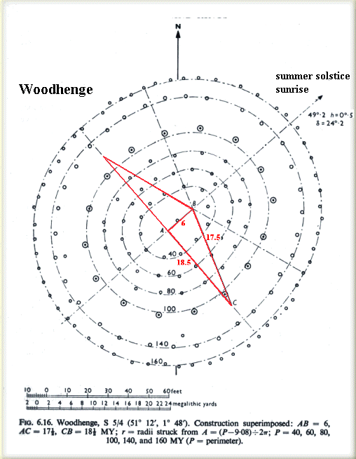 diameter of the Aubrey Circle we get 16,200 feet which is “the exact diameter of Plato’s Atlantis”.(bv) Now, a ten-minute search on the Internet reveals FIVE different figures for the diameter of the Circle, ranging from 271.6’ to 288’. Combining that with the uncertainty attached to the value of the unit of measurement employed by Plato, it is clear that any claim of a connection between the Aubrey Holes and Atlantis is at best tenuous and at worst foolish.
Jürgen Spanuth suggested that the five trilithons “most probably represented five sets of twins.” [0015.85], an idea echoed later by Dieter Braasch(as). Spanuth was adamant that a commonly held view linking Stonehenge with Hyperborea was incorrect as Hyperboreans had come from Jutland.
Two Swedish researchers, Nils-Axel Mörner & Bob G. Lind have proposed(bm) that the Ales Stones in Sweden were built with the same basic geometry and using the megalithic yard as a standard of measure as Stonehenge.
Harry Sivertsen has written a paper about the metrology of Stonehenge with the ingenious title of ‘The Metrology of Stonehenge’. In it, he pulls together data from Egypt, Mesopotamia, India, Welsh churches and, of course, Stonehenge(cm).
The late Philip Coppens echoed(b) the views of a fellow Belgian, Marcel Mestdagh, that there might be a connection between monuments within the Stonehenge Heritage Site and Atlantis, namely Woodhenge, which comprised of posts arranged in six concentric circles. The suggestion is that this arrangement is in some manner a reflection of the concentric features in Atlantis described by Plato. I can only consider this to be highly speculative, somewhat akin to the suggestion(c) that Stonehenge I was an earthquake predictor.
In March 2015, the UK’s MailOnline published an article(ch) concerning some sites with unexplained concentric circles in China’s Gobi Desert. The article notes some superficial similarities with Stonehenge. Paolo Marini [0713]. also claimed that the concentric circles of Atlantis are reflected in the layout of Stonehenge! In 2011, Shoji Yoshinori suggested that Stonehenge was a 1/24thscale model of Atlantis(cg). He includes a fascinating image in the pdf.
For those interested, a recently reconstructed German counterpart of Woodhenge has the original dated to 2300 BC(aq). A Portuguese ‘woodhenge’ was reported in 2020(bk), which is thought to be the work of the Bell Beaker people (3500 – 2000 BC).
However, in the meanwhile, we will have to be content with a recent book by Professor Mike Parker-Pearson, Stonehenge: Exploring the Greatest Stone Age Mystery [839], which includes all the discoveries revealed by the recent ten years of investigation.
A 2014 offering from Professor David P. Gregg, The Stonehenge Codes [977], throws further light on the mathematics used for the building and development of Stonehenge over a 1500-year period was consistently the same polygon geometry. Gregg has also identified an earlier Babylonian influence. His book has considerable numerical content that many will find heavy going. Some of the text of the book is available online(j). The July 2014 edition of the BBC Focus magazine offers evidence that the history of the Stonehenge location can be traced to nearer the end of the Ice Age.
It has been generally accepted for many years that the bluestones (spotted dolerites) at Stonehenge had been brought from the Preseli Mountains of Wales. Now (Nov.2013) evidence has been presented that identifies the precise outcrop, Carn Goedog, as their source(h).
However, in November 2015, a report threw doubt on the existence of a Neolithic quarry in the Preseli Hills(ag). Confusingly, the following month it was reported(ah) that studies carried out in Wales suggested that the stones had been erected there first before their transportation to Wiltshire. In May 2016, the controversial matter of the method of transportation from Wales was claimed to have been resolved when it was demonstrated by students from University College London, supervised by Parker-Pearson that the bluestones could have been mounted on a sycamore sleigh and dragged along timbers requiring far less effort than was previously expected.(ao) Parker-Pearson believes that originally the stones had been part of a Welsh tomb that was dismantled and brought to Wiltshire as the successors migrated westward(ap). There is now a search underway to locate the site of the original monument in Wales.
In 2004, Jennifer Viegas from Discovery News (June 14) suggested that Stonehenge had been built by Welshmen based on remains found in builders’ graves found close to Stonehenge(bx).
A further twist to the Welsh connection was proposed in a 2021 paper(bs), again in Antiquity, when a team of archaeologists proposed that the Stonehenge bluestones may have been taken from one or more pre-existing stone circles. One candidate is to be found at the remains of the dismantled Waun Mawn circle in the Preseli Hills(be). A few years ago Robin Heath published Proto Stonehenge in Wales [1853] which expanded on this Welsh connection.
>“A century has passed since British geologist Herbert Henry Thomas published his seminal 1923 study on Stonehenge, in which he traced the origin of the “bluestones” that make up the monument’s inner circle to the Preseli Hills in western Wales. Among these bluestones — so called because they acquire a bluish tinge when wet or freshly broken and to distinguish them from the “sarsen” stones that make up the outer circle — Thomas included a 16-foot-long (4.9 meters) flat-lying, gray-green slab of stone known as the Altar Stone.
It now appears that Thomas’ assessment was flawed, Richard Bevins and his colleagues have found in a new study, published in the October (2023) issue of the Journal of Archaeological Science: Reports. While Thomas “quite rightly” pinpointed the source of some stones to outcrops in western Wales, the Altar Stone likely came from a completely different location, possibly an unknown quarry in northern Britain, Bevins said.”(cv)<
Parker-Pearson published a paper in the February 2019 edition of Antiquity in which he reports on his research at the Welsh site, where he found some of the tools used to extract the pillars and determined the method of transportation(bc).
The transportation question received new attention with a study that suggested that “to move these stones such long distances, the builders likely manoeuvred them onto timber sledges and rolled these over logs,” using pig fat as a lubricant to minimise the friction between the sled and the logs. It is suggested that ceramic vessels, with high concentrations of pig fat, found on-site at Durrington Walls, may have been used to collect fat from the carcasses as they were roasted on a spit, which was then stored as lard or tallow! (bf) My question is, how many pigs are needed to grease a path for a stone from Wales to Stonehenge?
Further investigation has produced the claim by Paul Devereux that the rock there was chosen because of its acoustic qualities(I), raising the possibility that Stonehenge was the site of the first ‘rock’ concert. A more wide-ranging essay on the subject of archaeoacoustics is available online(ak). Robert Hensey notes [1766.40] that acoustic experiments have been carried out inside Newgrange and Cairns I & L at Loughcrew, while in the Orkneys, Aaron Watson and David Keating have investigated sound effects at two passage tombs.
According to Trevor Cox, professor of acoustic engineering at England’s Salford University, the Neolithic temple (of Stonehenge) had unique properties capable of significantly altering and amplifying speech and musical sounds(cf). His theories were also explored in a June 2023 article on the BBC website(cp).
After centuries of being described as one of the wonders of the megalithic world, the construction skills of Stonehenge’s builders have been harshly criticised by Professor Ronald Hutton of Bristol University, who went as far as to describe them as ‘cowboy builders’(n).
In 2012, Gordon Freeman, a Canadian scientist, published Hidden Stonehenge [891] in which he offers an extensive study of a Native American “medicine wheel” in Alberta and compares its astronomical alignments with that of Stonehenge, revealing ‘incredible’ similarities(bu). His book highlights the use of sophisticated astronomical knowledge at both locations, in the very distant past suggesting cultural links millennia before Columbus!
>Although full scientific investigation has yet to be carried out, a circle of standing stones submerged of the coast in Lake Michigan, initial reports are intriguing(cx). However, until properly studied, wild speculation has offered some outlandish theories regarding the date, builders and purpose of these stones.<
A somewhat cruder but equally effective winter solstice alignment was recently identified in the Chilean Andes(aw).
A site in Australia discovered in the first half of the last century by Frederic Slater (President of the Australian Archaeological Society) and dubbed ‘Australia’s Stonehenge’ was bulldozed in 1940 on the orders of the Australian Government! The location, obviously, never as impressive as its namesake on Salisbury Plain, has been again identified and using drawings made over seventy years ago has enabled a computer-generated image of the site to be made(t). A father and son team, Steven & Evan Strong have recently relocated to the damaged site(af).
In the Strait of Sicily, a ‘Stonehenge’ has been identified on the small island of Lampedusa, by Diego Ratti and described on a generously illustrated website(e). However, the application of the term to almost any megalithic monument, particularly by the media, has debased its value.
In May 2013, Melville Nicholls published a Kindle ebook, Children of the Sea God, in which he argues strongly for a Stonehenge built by Atlanteans, better known as the Bell Beaker People!
Robert John Langdon has now proposed(g) that Stonehenge was constructed by megalith builders, around 8500 BC, who had migrated from Doggerland/Atlantis as it became submerged and that the Altar Stone at Stonehenge points to Doggerland! Langdon is highly critical of the generally accepted interpretation of various features found at Stonehenge, listing13 items that he claims “don’t make sense”(bp).
>John Chaple has drawn attention to a letter from Quintus to his brother Marcus Tullius Cicero regarding the construction of Stonehenge, possibly based on information received from Druids!
” The temples of the Britons are raised and constructed in a circular form, with obelisks of stone, over which are imposts, all of huge dimensions untouched by the chisel; a peace offering to Geranius, or Apollo, the sun. The huge stones of which they are composed, lay scattered by the hand of nature on the plain: these, with myriads of labourers, the high priest caused to be rolled up on the inclined planes of solid earth, which had been formed by the excavation of trenches, until they had attained a height equal to their own altitude; these pits being dug, they were launched from the terrace and sunk so as to stand perpendicular, at due and equal distances in the circle, and over these were placed others horizontally. After having completed one circle, they formed another that is concentric at some distance, and towards the extremity of the area of the inner circle, they placed a huge stone for the purpose of religious rites. When the sun enters into Cancer, [mid summer] is the greatest festival of the god; and on all high mountains and eminences of the country, they light fires at the approach of that day, and make their wives, their children, and their cattle, to pass through the fire, or to present themselves before the fire in honour of the deity. Deep and profound is the silence of the multitude during this ceremony, the appearance of the sun above the horizon, when, with loud and continued exclamations, and songs of joy, they hail the utmost of that luminary, as the supreme triumph of the symbol of the god of their adoration.”(cw)<
Shoji Yoshinori has suggested that Stonehenge was intended as a model of Atlantis(k), as had also the late Philip Coppens(b).
It is quite obvious that more convincing evidence is required if any claim of a Stonehenge/Atlantis connection is to gain greater traction. In 2018, David L. Hildebrandt published Atlantis – The Awakening [1602], in which he endeavoured to do just that with a mass of material that he claims supports the idea of Atlantis in Britain and Stonehenge as the remnants of the Temple of Poseidon. He suggests that the five trilithons represent the five sets of male twins, an idea voiced by Jürgen Spanuth and more recently by Dieter Braasch. Even earlier George H. Cooper proposed Stonehenge as the Pillars of Herakles. I am not convinced by the spirited defence of his hypothesis, as I consider his date too early and the location too far from Athens or Egypt to consider them to be within ‘easy striking distance’ for the purpose of invasion.
Jürgen Spanuth claimed that “Among the racecourses of the Bronze Age still in existence today must be counted the stone circle of Stonehenge which must have been erected by men of the Atlantean culture many centuries before the Atlantis report was written. The racecourse at Stonehenge, in its original, immense dimensions, cannot be an imitation of a Greek stadium.” [017.126]
As recent as the summer of 2014 evidence was accidentally discovered(o) that suggested that the Stonehenge megalithic stones form a complete circle. Commenting on the discovery Susan Greaney from English Heritage said “A lot of people assume we’ve excavated the entire site and everything we’re ever going to know about the monument is known, but actually there’s quite a lot we still don’t know and there’s quite a lot that can be discovered just through non-excavation methods.” An extensive digital mapping project carried out at Stonehenge by researchers from the University of Birmingham and the Ludwig Boltzmann Institute of Vienna has revealed, “that the area around Stonehenge is teeming with previously unseen archaeology and that the application of new technology can transform how archaeologists and the wider public understand one of the best-studied landscapes on Earth.”(p)
December 2014 saw an encampment site just 1.5 miles from Stonehenge has its date confirmed at around 4000 BC(s).
Marden Henge, situated between Stonehenge and Avebury is reckoned to be ten times bigger than Stonehenge and has now (2015) seen the start of a three-year, £1,00,000, dig by 80 archaeologists hoping to unlock its secrets(a). Dr Jim Leary, a leading archaeologist working at the site is convinced that Marden may turn out to be more significant than Stonehenge(w).
Earlier in 2015 Tim Daw, a steward at the Stonehenge site claimed that he had discovered a previously unknown alignment, involving a line of stones at 80 degrees to the axis of the monument. His theory is that the tallest stone at Stonehenge points towards the midsummer sunset and has been observed to be correct(v).
Some years ago a University of Manchester team led by Professor Julian Thomas explained that “The Stonehenge Cursus is a 100-metre wide mile-long area which runs about 500 metres north of Stonehenge.” which we have now “dated at about 3,500 years BC – 500 years older than the circle itself.”(ca)
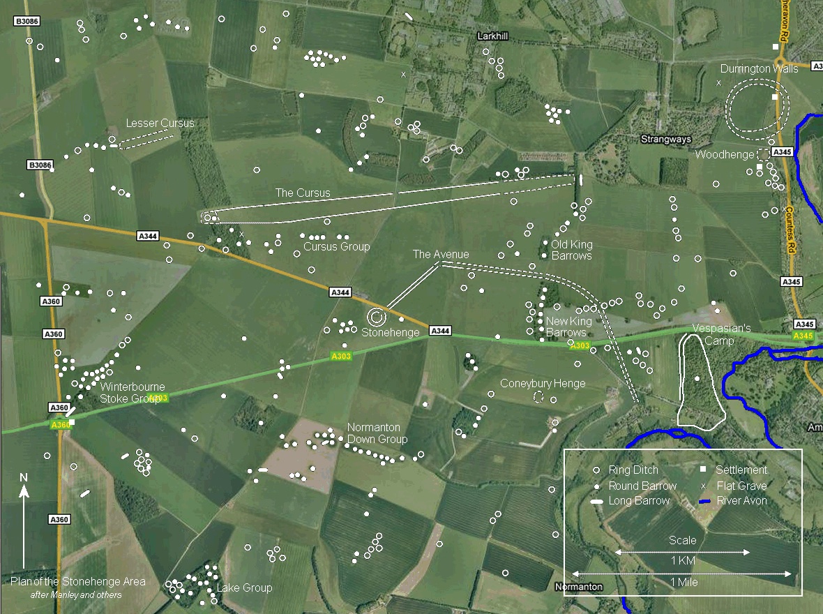
The archaeological importance of Stonehenge was boosted further in September 2015 with the announcement that a line of nearly 100 buried stones had been discovered just a mile away, beside the Durrington Walls ‘superhenge’(y). There are images available, including a short video clip relating to this new discovery(z). Subsequent excavations revealed no stones, but 90 holes that had held wooden posts.(bn)
In June 2020, the significance of Durrington was greatly enhanced by the revelation that adjacent to the ‘Walls’ is a series of shafts five metres deep and ten metres in diameter. The shafts are arranged in a circle having a diameter of 1.2 miles. The site is 1.9 miles northeast of Stonehenge(bj). Further comment was published in November 2021(cd).
In November 2015, the New York Times published an updated overview(ae) of the various excavations that have taken place in the vicinity of Stonehenge.
Sarah Ewbank has now offered us a fascinating new theory regarding the original purpose and plan of Stonehenge. In a fully illustrated website(al) she reveals that the structure was conceived as “a ‘Cathedral-like’ building with a massive oak-framed roof, and a huge hall at its centre.”
Further discoveries are listed on the Heritage England website(ab). What is not listed there is the information that Stonehenge was constructed by giants on the instruction of the Devil! This b.s. tidbit was imparted to us in April 2016 by Dr Dennis Lindsay on the TV show of disgraced US evangelist Jim Bakker(am). Another blog from Jason Colavito exposed further Stonehenge nonsense, this time from New Zealander, Ted Harper, who has recently claimed that the Wiltshire monument together with the Great Pyramid, both warn of a meteor strike in 2020.
Theories relating to Stonehenge and Atlantis seem to proliferate at comparable rates. In a new book, The Memory Code [1258], by Lynne Kelly, she proposes that the Wiltshire monument is a giant mnemonic(ar) and that other megalithic sites also were.
July 2017, saw a BBC review of the recent acceptance of Stonehenge as just a part of a huge complex of monuments, with a hint of more to come(at).
In June 2019, Dr Christophe Snoeck, a Belgian archaeological scientist offered evidence for the origins of some of the cremated human remains discovered at Stonehenge. “During his doctoral research, he developed a method to extract information about the geographical origin of cremated individuals.“ This method, he says, “was applied to 25 cremated individuals from Stonehenge and our results show that 40% (10 out of 25 analysed individuals) did not live near Stonehenge in the last decade or so prior to their deaths but came from further away. Some might actually have originated from west Wales where the bluestones came from, some 250 km away,” he adds. “This shows the importance of the site in the British landscape during the Neolithic period.” (bd) Italian scientists have also been working on new ways of gleaning information from cremated remains(be).
In 2020, it was announced that acoustic engineers from the University of Salford had demonstrated that Stonehenge had acoustic qualities that allowed “any sounds produced inside the temple would have been much less audible to anybody outside the circle, despite the monument almost certainly not having a roof.
The findings, therefore, suggest that any sounds generated by activities carried out inside the circle were not intended to be shared with the wider community. This reinforces theories suggesting that the potential religious activities conducted inside Stonehenge were reserved for an elite of practitioners, rather than for a wider communal congregation.”(bl)
In May 1922 NG published its first photo of Stonehenge, now, a century later, it returned to this remarkable monument for its cover story in a 2022 edition(cj). It highlights how the use of new technologies has greatly enhanced our knowledge of the site and the people who built it. Jim Leary, a lecturer in field archaeology at the University of York admits that “a lot of the things we were taught as undergraduates in the 1990s we know now simply aren’t true.” This beautifully illustrated article is a useful update on developments at this huge UNESCO World Heritage Site.
In the February 2023 edition of the Antiquity journal it published a paper by Giulio Magli and Juan Antonio Belmonte that effectively debunked many of the various theories relating to Stonehenge put forward over the past seventy years. “All in all, the alleged “Neolithic” solar-precise Stonehenge calendar is shown to be a purely modern construct whose archaeoastronomical and calendrical bases are flawed.”(cn)
[1613]+ Available online: https://archive.org/details/stonehengedecode00gera/mode/2up
[1696]+ https://archive.org/details/b30448554/page/n8/mode/2up
(a) Daily Express, Fri. June 19, 2015
(b) See Archive 2140
(c) https://lunaticoutpost.com/showthread.php?tid=11497
(d) https://www.sciencedaily.com/releases/2010/11/101130010931.htm
(e) See: Archive 2211 (text only)
(f) https://www.bbc.co.uk/news/uk-scotland-north-east-orkney-shetland-23286928(g) https://robertjohnlangdon.blogspot.co.uk/#!/2013/06/stonehenge-atlantis-momentous-discovery.html
(h) https://www.bbc.co.uk/news/uk-wales-25004282
(h) https://www.bbc.co.uk/news/uk-wales-25004282
(j) https://old.world-mysteries.com/gw_DavidGregg.htm
(k) https://www.pipi.jp/~exa/kodai/kaimei/stonehenge_is_small_atrantis_eng.pdf
(m) BBC Focus Magazine, July 2014, p.51
(n)https://www.dailymail.co.uk/sciencetech/article-2671664/Stonehenge-built-cowboys-lasted-well.html
(q) https://www.ancient-origins.net/ancient-places-europe/solving-enigma-stonehenge-001616
(s) https://www.bbc.com/news/uk-england-wiltshire-30540914
(t) https://www.grahamhancock.com/forum/StrongSE2.php
(u) https://www.mondovista.com/stone.new.html
(v) https://www.bbc.com/news/uk-england-wiltshire-33205212
(x) See Archive 2657
(z) https://www.lbiarchpro-imagery.at/stonehenge2015
(aa) https://www.bbc.com/news/magazine-34282849
(ab) https://heritagecalling.com/2015/09/23/7-new-discoveries-about-stonehenge/
(ac) https://heritageaction.wordpress.com/2016/05/26/how-did-they-move-the-bluestones/
(ae) Stonehenge Begins to Yield Its Secrets – The New York Times (archive.org)
(ai) See Archive 2832
(aj) https://www.walesonline.co.uk/news/wales-news/stonehenges-bluestones-were-moved-wales-10591475
(ak) https://dailygrail.com/Hidden-History/2016/1/Archaeoacoustics-Listening-the-Sounds-History
(ar) https://www.thecourier.com.au/story/4104488/the-palace-of-memory/
(at) https://www.bbc.com/travel/story/20170713-why-stonehenge-was-built
(au) The images of Stonehenge they don’t want you to see – Ancient Code (archive.org)
(av) https://www.livescience.com/62619-did-glaciers-carry-stonehenge-bluestones.html
(ax) https://www.atlasobscura.com/articles/victorian-stonehenge-picnic-photos
(ay) https://issuu.com/os012/docs/stonehenge_a4_pdf
(az) https://www.rte.ie/news/leinster/2018/0711/977969-newgrange/
(ba) https://web.archive.org/web/20190601213915/https://www.ancient-wisdom.com/extremasonry.htm
(bb) https://en.wikipedia.org/wiki/Bronze_Horseman
(bc) https://www.livescience.com/64801-stonehenge-temporary-monument.html
(be) https://www.latimes.com/science/new-way-to-decode-burned-bones-story.html
(bf) https://www.sciencemag.org/news/2019/07/ancient-people-may-have-used-pig-fat-build-stonehenge
(bg) https://www.ancient-origins.net/news-history-archaeology/lunar-calendar-0012340
(bh) https://bradshawfoundation.com/news/world_heritage.php?id=Moving-the-stones-of-Stonehenge
(bi) https://www.bibliotecapleyades.net/arqueologia/esp_esferas_costarica05.htm
(bk) https://www.ancient-origins.net/news-history-archaeology/perdigoes-neolithic-woodhenge-0014084
(bn) ‘New Stonehenge’ was made of WOOD | Daily Mail Online
(bp) The Post Glacial Flooding Hypothesis: The Great Stonehenge Hoax (archive.org)
(bq) Stonehenge Astronomically Considered Index (sacred-texts.com)
(bt) http://news.bbc.co.uk/2/hi/uk_news/wales/south_west/5072664.stm
(bu) https://www.thestar.com/news/canada/2009/01/29/alberta_sun_temple_has_5000yearold_calendar.html
(bv) https://jjswn35.wordpress.com/article/atlantis-eden-how-to-find-2vfxjftuay98o-9/
(bw) Stonehenge – Voices from the Dawn
(bx) Archive 6480 | (atlantipedia.ie)
(by) PREDICTING ECLIPSES WITH THE STONEHENGE (archive.org)
(bz) https://www.nature.com/articles/s41599-018-0210-9
(ca) https://www.sciencedaily.com/releases/2008/06/080610095001.htm
(cb) https://www.livescience.com/stonehenge-pillars-mesozoic.html
(cc) Stonehenge: Did ancient ‘machine’ move stones from Wales? – BBC News
(ce) https://www.sciencedaily.com/releases/2022/03/220301192407.htm
(cf) ADVANCED ACOUSTICS AT STONEHENGE – ATLANTIS RISING THE RESEARCH REPORT
(cg) http://www.pipi.jp/~exa/kodai/kaimei/stonehenge_is_small_atrantis_eng.pdf
(ci) https://www.sacred-texts.com/neu/eng/sac/index.htm
(cj) National Geographic, August 2022
(ck) The Victorian Vicar Who Thought the Nephilim Built Stonehenge and the Pyramids – JASON COLAVITO
(cl) https://ui.adsabs.harvard.edu/abs/1999AAS…195.9201C/abstract
(cm) (99+) The Metrology of Stonehenge 2020 | Harry Sivertsen – Academia.edu
(cn) https://phys.org/news/2023-03-stonehenge-calendar-shown-modern.html
(co) Neolithic Stone Balls: The Northern Rosetta Stone? | Ancient Origins (ancient-origins.net)
(cp) What did Stonehenge sound like? – BBC Travel
(cq) https://www.academia.edu/64551399/Researching_Stonehenge_Theories_Past_and_Present
(cr) https://www.academia.edu/75967939/New_Theory_About_Stonehenge_Stonehenge_Royal_Palace_Author_Dimitar_Alekseev_Dimitrov (link broken) See short video – Stonehenge explained by Bulgarian scientist Dimitar Al. Dimitrov! 2020 – YouTube *
(cs) https://www.britam.org/Proof/Attributes/roleDolmen.html
(cu) https://www.academia.edu/96803677/The_Stonehenge_Builders_came_from_Turkey_so_whats_new