Latest News

NEWS September 2023
September 2023. Hi Atlantipedes, At present I am in Sardinia for a short visit. Later we move to Sicily and Malta. The trip is purely vacational. Unfortunately, I am writing this in a dreadful apartment, sitting on a bed, with access to just one useable socket and a small Notebook. Consequently, I possibly will not […]Read More »
Joining The Dots
I have now published my new book, Joining The Dots, which offers a fresh look at the Atlantis mystery. I have addressed the critical questions of when, where and who, using Plato’s own words, tempered with some critical thinking and a modicum of common sense.Read More »
Paul Heinrich
Tiwanaku (Tiahuanaco)
Tiwanaku (Tiahuanaco) is an ancient city whose remains are located over two miles above sea level near the southern end of Lake Titicaca on the Altiplano of Bolivia. It was first encountered by Spanish conquistadors in 1549. Tiwanaku has all the features of a harbour, which has led some to describe it as the seaport of nearby Puma Punku another remarkable ancient site(o).
 The ruins are scattered over a number of square miles through which the Guayqui-La Paz railway was constructed, which was responsible for the breaking up of many monuments to provide ballast. Before that, stone from the site was used in the construction of nearby homes and a church.
Belisario Díaz Romero believed that Tiwanaku had been built by a race of people he calls Homo atlanticus, who had come to America from Atlantis over a landbridge from the east, outlined in his 1906 book Tiahuanacu[1235]. Heather Pringle notes(t) that before Romero, “Francis de Castelnau (1810-1880), for example, proposed in the mid-19th century that Tiwanaku was the work of wandering Egyptian pharaohs, as opposed to the ‘imbecilic race that inhabits the country today’.”
The controversial Arthur Posnansky, who linked Tiahuanaco with Aztlan, the mythical “white” island homeland of the Aztecs investigated them in the early 20th century. The similarity of Aztlan with the name of Plato’s city has excited some straw-clutching Atlantis seekers into claiming a definite connection between the two.
Posnansky also noted that the expected alignments of structures at Tiwanaku were offset by an amount that suggested their construction at a time when they would have been correctly aligned to the cardinal points. He, after many years of study, was convinced that Tiahuanaco was the oldest civilisation on Earth [516] dating it to around 15,000 BC, which he later reduced to 10,000 BC.
In the 1920s, Edmund Kiss studied the ruins of Tiwanaku and concluded that it had been constructed by Nordic refugees from Atlantis which had been destroyed by a falling moon! His ideas were enthusiastically received back in Nazi Germany. A further expedition was planned but never materialised because of the start of World War II.(u)
Dr Graham Holton, an Australian commentator has written about the pseudo-science practised in the early 20th century at Tiwanaku by the likes of Posnansky and Kiss and endorsed by Hörbiger and Hans Bellamy(al)(am).
Although, as you can see below, Posnansky’s work and particularly his dating of Tiwanaku has been rejected by many, he still has supporters. In Graham Hancock‘s 1995 book Fingerprints of the Gods [275], he supported Posnansky’s date, referring to his work throughout the book. Ian Alex Blease, a devout sceptic took issue with this endorsement (aa). For my part, I note that Hancock was happy to support Posnansky in ‘Fingerprints’, but in America Before [1680], despite its title, he gives Posnansky’s date no mention, perhaps because it clashed with his new date for the destruction of his ‘Lost Civilisation’!
Charles Orser Jnr. debunked Posnansky’s dating in a 2001 article(k) as did Paul Heinrich(n).
Marin, Minella & Schievenin [972.97] “Between 1927 and 1930 several scientists, including Hans Ludendorf, at the time director of the Astronomical Observatory of Potsdam; astronomer Arnold Kohlshutter, University of Bonn; Dr Rolf Muller, University of Potsdam and Dr Friedrich Becker, Specula Vatican, meticulously checked the archaeological-astronomical research of Posnansky for accuracy. After three years of work these scientists corroborated his thesis.”
>Before retirement, R. Cedric Leonard supported Posnansky’s early date for Tiwanaku citing a number of atronomers who endorsed his chronology. “Between 1927 and 1930 Prof. Posnansky’s conclusions were studied intensively by a number of authorities. Dr. Hans Ludendorff (Director of the Astronomical Observatory of Potsdam), Friedrich Becker of the Specula Vaticana, Prof. Arnold Kohlschutter (astronomer at Bonn University), and Rolf Müller (astronomer of the Institute of Astrophysics at Potsdam) verified the accuracy of Posnansky’s calculations and vouched for the reliability of his conclusions.
The conventional practice of dating Tiahuanacu as beginning c. 200 A.D. and collapsing c. 1000 A.D. started with Wendell Bennett’s excavations, which turned up numerous examples of pottery, small statues and other artifacts. Since it is common for later arrivals to be awed by massive ruins (sometimes attributing their origin to supernatural beings, thus replicating the “sacred” images on their own pottery and textiles), I think it is a mistake to fuse the two cultures into one, implying that the later arrivals were the same people who built the original ruins. I believe Bennett and his successors are all guilty of such an error.” (ap)<
R. Cedric Leonard believed that Posnansky’s date addressed all of the mysteries associated with the site and “Thus I think it likely that Tiahuanaco was built at sea level c.15,000 B.C. as an Atlantean port.”(z)
The American archaeologist, Neil Steede, while reviewing Posnansky’s date, thought that a date of 7000-5000 BC was more appropriate(aj).
At the other end of the spectrum, Emmet Sweeney, an ardent chronology revisionist claimed that “most probably, Tiahuanaco was built around the same time as pharaoh Djoser’s Step Pyramid at Sakkara in Egypt. It can thus claim to be among the oldest of human monuments [700.208].” Tiwanaku is conventionally dated between 200 BC and 100 AD, while the Step Pyramid is thought to have been constructed around 2650 BC.
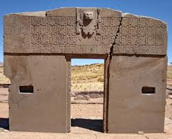
Some researchers, including Jim Allen, have studied Tiwanaku’s remarkable Gate of the Sun and identified the figures carved on it as a sophisticated calendar(v).
A paper from Marco Antonio Cabero regarding the ‘Gate’ throws a modicum of doubt on its possible use as a calendar. Instead, he focused on the other side of the monument where he claims there is evidence that the ancient people of Tiwanaku knew the ‘golden number’, phi.
“The composition of the front face of the Gate of the Sun in Tiwanaku presents, anthropometric, and bilateral symmetry. On the back side, there are also harmonic proportions but with less significance. These proportions were not found before because the study of the content of its engraving frieze was believed to be a calendar, an idea that has been so widely extended, that any other interpretations were ignored (however, the presence of these proportions does not exclude the possible existence of some type of calendar). The Gate of the Sun may not be part of a temple, but its content could also be considered as the expression of a monument in itself; a work that testifies to the importance of knowledge, art, and science “(ac).
Ashley Cowie has recently proposed that Tiwanaku was located on an ancient Prime Meridian(w).
Also eye-catching is the claim(l) by Roger Elefant that later construction at Tiwanaku was carried out by the Vikings!
However, a more recent, but catastrophic, explanation is offered by Stephen Smith(d) on the Thunderbolts.info website. Perhaps Smith’s ideas might be combined with the studies of George Dodwell to produce a more comprehensive hypothesis. Posnansky’s date is greatly at variance with conventional dating that puts the flourishing of Tiwanaku from 1200 BC until 1200 AD. The latter part of that period roughly coincides with the existence of the Wari Empire, a possible rival of Tiwanaku(e).
In 2013, Jason Yaeger and Alexei Vranich published a detailed study of the chronological development of Tiwanaku and Puma Punku. This is now available on the Academia.edu website(ao). Anyone seeking support for ancient astronauts, giants or Atlantis will be greatly disappointed. The authors confirmed a starting date for monumental construction at the site of no earlier than 200 BC, which continued intermittently until the arrival of the Spanish invaders. Their report is the result of the ‘hard slog’ required by real archaeology.
Several claims attempting to link Tiahuanaco with Atlantis have been made, with one anonymous blog(y) insisting that it was the capital of Atlantis. James Bailey was an early advocate [149] of a Peruvian Atlantis with its capital at Tiwanaku or Chan Chan, which was probably the largest pre-Colombian city in South America.
The claim of a direct connection between Tiahuanaco and Atlantis is hard to accept on a number of grounds; for example, the idea of an army travelling from the west coast of South America to attack Greece in the east of the Mediterranean is not tenable. That there was an advanced culture in the Andes is undeniable but to link it to Plato’s story is stretching credibility to extremes. Lake Titicaca and Tiahuanaco have plenty of mysteries still to be explained. In 1980 the Bolivian scholar, Hugo Boero Rojo, aided by one of the local natives, Elias Mamani, located underwater ruins off the coast of Puerta Acosta[576]. His discoveries included megalithic temples, flights of stairs and stone roads.
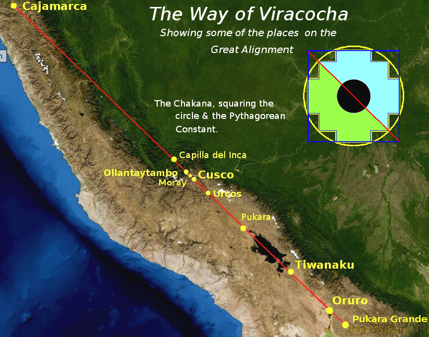 More recently, Dave Truman has written about an alignment known as ‘The Way of Viracocha’ that runs from Cajamarca in the north, through Cuzco and Tiwanaku and finishing at Pukara Grande(p), oriented exactly 45° west of true north. Truman has built on the work of Maria Sholten d’Ebneth (1926-2007), who wrote of the La Ruta de Wiracocha[1236] in the 1970s(q). Others have expanded on her work, but usually in Spanish. Truman has speculated on whether “Viracocha, the great teacher and restorer of civilisation in the Andes, in some way embodied the scientific knowledge of a sophisticated, but long-forgotten high culture?” Truman
also discusses the ‘chakana’ or Andean stepped cross (see right) and its possible meaning.
It was reported in October 2013(g) (that a team of Belgian and Bolivian archaeologists had found an assortment of ceramics, gems and gold objects at an apparent ceremonial site beneath the waters of Lake Titicaca, which was sacred to the Incas and Tiwanakus. It was not until 2019 that images of some of the artefacts recovered from the lake were widely published(x).
We cannot leave the matter of mysterious Tiahuanaco without referring to the fact that some miles further south is Lake Poopó beside which Jim Allen is convinced that the city of Atlantis was located. Allen claims that the large plain to the west of the lake is the plain mentioned by Plato as being adjacent to the city of Atlantis. In a recent documentary “Atlantis in the Andes” broadcast by ‘Discovery Civilization’, Allen identified Tiahuanaco as one of the ten kingdoms of Atlantis. However, I cannot help noticing that while Tiwanaku, claimed to be 17,000 years old, provides us with an astonishing wealth of structures and finely dressed stone, Allen’s chosen Atlantis site, Pampa Aullagas, offers little more than rubble!
Another supporter of an Andean Atlantis is Sean Bambrough, who has been developing a theory since 1999 that identifies Tiwanaku as the city of Atlantis(h). He has now published his magnum opus on the academia.edu website(ae).
In February 2015, Marcelo Ozorio also suggested a link with Plato’s Atlantis and most interesting is the huge number of images included on his site(i). There is also a large collection of related images on a YouTube clip(m).
In 2022, Marco Vigato‘s book, Empires of Atlantis [1830] was published, which included Tiwanaku as part of the evidence for his hyperdiffusionist Atlantis(ab).
In 2008, David E. Flynn brought to public attention an astonishing series of satellite photos(a) that show a vast network of the remains apparently of man-made structures that extend for many miles around Lake Titicaca. These ‘geoglyphs’ encompass Tiahuanaco.
The most remarkable collection of early photos of the Tiwanaku site can be found on the Above Top Secret website(b). The accompanying text makes a strong case for treating the location as archaeologically contaminated and as a consequence that many of the dates proposed for the site should be considered suspect. Other mysteries are the fact that saltwater Lake Titicaca contains known sea life and that old waterlines are slanted(c).
In late March 2015, the Bolivian government announced(j) that ground-penetrating radar had identified what appeared to be a buried pyramid in the Tiwanaku complex as well as other ‘anomalies’ and that excavations may start in May or June.
A mixed Spanish and English website(f) offers a number of interesting papers including a chapter from Posnansky’s book Tiahuanaco: The Cradle of American Man.
Archaeology magazine has an interesting Q & A paper relating to the history and current state of preservation at the Tiwanaku site(s).
A May 2017 report(r) confirmed that the entire Tiwanaku complex is much more extensive than previously thought, covering an area of at least 650 hectares (1,675 acres).
Joseph Davidovits who controversially proposed that Giza’s Great Pyramid stones had been cast rather than carved has also claimed that other well-known structures had been created in a similar manner, such as at Tiwanaku and Puma Punku in Bolivia(ah) and Easter Island(ai). He offers scientific evidence to support this claim in a very interesting video(ak). My objection to his ‘cast rather than carved’ hypothesis, particularly in relation to Easter Island, is that partially finished statues are visible today in a quarry still attached at the back to the rock from which they were carved as well as some of the tools used for the job. Images of these can be seen in Thor Heyerdahl’s Aku-Aku [1938].
Brien Foerster is an American writer who now lives in Cuzco, the former Inca capital in Peru. He has studied the ancient cultures of the Andes and believes that many predated the Incas and had advanced technologies that permitted the precise drilling of stone(af), the quality of which he has compared with examples found in Egypt and like Chris Dunn concluded that their level of accuracy could not have been achieved without possession of a high technology, now lost(ag). He has expanded on this in his 2014 book, Lost Ancient Technology of Egypt [1487].
A fully illustrated guide to the intriguing monuments of Tiwanaku/Puma Punku is now available which is an excellent introduction to the site including a map by Javier Escalante Moscoso(an).
(a) https://www.freerepublic.com/focus/f-chat/1977971/posts
(b) https://www.abovetopsecret.com/forum/thread732575/pg1
(c) https://www.thunderbolts.info/wp/2012/04/30/tiwanaku/
(d) https://www.thunderbolts.info/wp/2013/04/03/tiwanaku-3/
(e) http://www.sci-news.com/archaeology/science-wari-tiwanaku-rival-empire-01473.html
(f) https://www.bibliotecapleyades.net/arqueologia/esp_tiahuanaco5.htm
(h) https://2rbetterthan1.wordpress.com/atlantis-south-americatiahuanaco/
(i) Tiwanaku, pre-columbian archaeological and world heritage site at Bolivia (viagem.space)
(k) https://www.mail-archive.com/ctrl@listserv.aol.com/msg62910.html
(l) https://atlantide-mu.over-blog.com/2013/12/terre-creuse.html
(m) https://www.youtube.com/watch?v=PkuoXm9uafI
(n) http://www.intersurf.com/~chalcedony/Tiwanaku.html
(o) See: https://web.archive.org/web/20170601230717/https://www.atlantisquest.com/prehistcity.html
(p) https://grahamhancock.com/trumand1/
(q) https://puri-aprendiendovida.blogspot.ie/2013/02/la-ruta-de-viracocha-camino-de.html
(s) https://interactive.archaeology.org/tiwanaku/qanda.html
(t) https://archive.archaeology.org/blog/the-fantasy-world-of-tiwanaku/
(u) https://theappendix.net/issues/2013/4/andean-atlantis-race-science-and-the-nazi-occult-in-bolivia
(v) https://blog.world-mysteries.com/science/the-gate-of-the-sun-calendar-from-ancient-tiwanacu/
(w) https://www.ancient-origins.net/events/unearthing-lost-meridian-tiwanaku-s-temple-builders-0010322
(y) https://grahamhancock.com/phorum/read.php?1,1063585,1063585#msg-1063585
(z) https://web.archive.org/web/20161107001948/https://www.atlantisquest.com/prehistcity.html
(aa) https://www.oocities.org/debunkinglc/tiwanaku.html (link broken)
(ab) https://www.amazon.com/Empires-Atlantis-Civilizations-Traditions-throughout/dp/1591434335
(ad) (PDF) Mathematics in Tiwanaku-The gold number in the gate of the sun (researchgate.net)
(ae) https://www.academia.edu/61088843/Atlantis_Found_in_the_Andes_by_V_Sean_Bambrough
(af) https://www.youtube.com/watch?v=xR7of1Lkef0
(ag) https://ahotcupofjoe.net/
(ah) https://www.geopolymer.org/archaeology/tiahuanaco-monuments-tiwanaku-pumapunku-bolivia/
(ai) https://www.geopolymer.org/library/video/they-came-from-america-to-build-easter-island/
(aj) QC2K – Neil Steede (archive.org)
(ak) https://www.geopolymer.org/library/video/they-came-from-america-to-build-easter-island/
(am) (99+) 2007 Chapter 3 Tiwanaku.doc | Graham Holton – Academia.edu
(an) Tiwanaku, the mysterious pre-Inca capital – mapaymochila.es
Lemuria
Lemuria was a name invented in 1864 by the English zoologist Philip Lutley Sclater (1829-1913) to describe a hypothetical landmass in the Indian Ocean that was used to explain the isolation of lemurs on Madagascar while related fossils were spread across Africa and South-East Asia. The name has also been credited to the English geologist, William Thomas Blanford (1832-1905). It is further claimed that Ernst Heinrich Haeckel (1834-1919), the German professor of zoology and ardent supporter of Darwin, had made a similar suggestion regarding a sunken continent before Sclater without attributing a particular name to it.
Sir John Murray (1841-1914), a renowned British oceanographer, claimed(d) to have identified traces of this lost continent in the Indian Ocean.
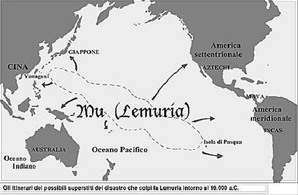
Mu on the other hand is the name given to a fictional continent that was supposed to have existed in the Mid-to-Southern Pacific Ocean and was given popular recognition by the writings of James Churchward who promoted it as the Atlantis of the Pacific. However, many writers continue to use the two words interchangeably. Frank Joseph links the destruction of ‘Lemuria’ with the Plagues of Egypt[106][107].
Paul Heinrich described the reincarnation of Lemuria in the following terms –
“Lemuria was reincarnated as a lost continent by Madame Blavatsky, the greatest of the modern occultists. Madame Blavatsky incorporated this concept of Lemuria, in a confused form, together with Atlantis and a bizarre mixture of scientific, occult, and Hindu religious material, including the Rig-Veda in her book, The Secret Doctrine. In this book, Lemuria became a lost continent, although still in the Indian Ocean, populated by ape-like hermaphroditic egg-laying creatures. Later writers of the occult, lost-continent tales, e.g. Annie Besant, and W. Scott-Elliot added their own detail and embellishment to the story of Lemuria, including dinosaurs and 12 to 15-foot bronze humanoids. The final event in the reincarnation of Lemuria occurred when writers of occult books moved the location of Lemuria from the Indian Ocean to the Pacific Ocean (de Camp 1954). Since then, mystics and psychics have written innumerable books about Lemuria and either tuned into the spiritual essence and vibrations or channelled for the spirits of long-departed Lemurians who never existed to begin with.” (a)(f).
It is disturbing that presumably intelligent people such as Egerton Sykes could have dared to describe the inhabitants of a non-existent country in the following terms – “The Lemurians were short, squat, with square faces and large ears, relatively ugly to Western eyes”(e).
Katherine Folliot in her Atlantis Revisited [054] has an interesting passage on Lemuria which I shall quote in full;
“Several Atlantologists have claimed that Lemuria was none other than the lost island of Atlantis, and although their theory has generally been considered to be fanciful, it may well be based on true facts. The word Lemuria is a bastardization of the Arab word ‘al amur’ which means ‘the West’, or ‘the western land’, and one may surmise that this was the name given by medieval Arab scholars to the ‘western land’ mentioned in the surviving Egyptian archives in Alexandria, which was stated to have disappeared under the sea. When Arabia lost its cultural predominance at the end of the Middle Ages, ‘al Amur’ became distorted into ‘Lemur’, and later into ‘Lemuria’, but the land this inaccurate name designated was in all probability the same as that described by the Egyptian priest of Sais to Solon, the ‘western land’ of Atlantis.”
Even more bizarre was a report in the 30th October 1955 edition of the San Francisco Examiner, which linked the American ‘Bigfoot’ or Sasquatch with a sunken Lemuria, suggesting that he was a highly developed survivor of that lost continent!
On a more serious note, February 2013 saw a report(b) of the discovery of an ancient continent in the Indian Ocean. At first sight fans of the Mu/Lemuria concept must have been quite excited until it was realised that this sunken landmass was dated as being many hundreds of millions of years old.
In a September 2014 interview(c) Graham Hancock echoed my views regarding Lemuria and Mu when he responded to a question on the subject with, “Well, let’s get Lemuria out of the way first. Lemuria is actually a 19th-century idea and there is no ancient text that refers to Lemuria. Lemuria is about the fact that fossils of a species of animal, the lemur, are found on both sides of the Indian Ocean. The suggestion was that there must have been some joining continent at one point between Madagascar and India. At any rate, I repeat, and this is my point – there’s no ancient testimony for the existence of a place called “Lemuria”. The ancient testimony from Mu is also extremely dubious since it rests on a 19th-century mistranslation of a Mayan text popularized by Augustus Le Plongeon and then subsequently elaborated by James Churchward in the 1920s and 1930s. But never mind the names, the fact is that we do have genuinely ancient traditions of lost civilisations and lost lands all around the world. That’s why I find Lemuria and Mu a bit of a distraction because Mu rests on a mistranslation of an ancient text and Lemuria is entirely a 19th-century idea.
>Jaime T. Licauco has written a number of papers about psychic surgery in the Philippines, including the question “Why are our faith healers and psychic surgeons concentrated in Pangasinan, the Ilocos region and Central Luzon?” He explains that “some people have advanced the theory that is is because Pangasinan and the Ilicos region were once centres of Lemurian civilization, referring to the ancient, lost, advanced civilization believed to have sunk in the Pacific Ocean 150,000 years ago!” (g)<
(b) https://www.bbc.co.uk/news/science-environment-21551149
(c) https://realitysandwich.com/223168/ancient-aliens-atlantis-ayahuasca/
(e) Atlantis, Vol.16. No.2, April 1963
(f) https://www.hallofmaat.com/atlantis/lemuria-here-we-go-again/
(g) https://lifestyle.inquirer.net/305657/sumeria-origins-man/ *
Flem-Ath, Rand & Rose

Rand and Rose Flem-Ath live in British Columbia, Canada. Both are librarians and have spent several years in the British Museum assembling evidence that they believe supports their contention that Antarctica was the home of Plato’s Atlantis. Together they wrote a highly controversial book, When the Sky Fell [0062], promoting the Antarctic location, which included an Introduction by the late Colin Wilson.
In 2000, Rand published his second book[063], co-authored with Colin Wilson on the subject of ancient civilisations including Atlantis. However, Wilson subsequently changed his views and switched his support to Robert Sarmast’s theory of Atlantis being located off Cyprus. Wilson revealed later, in a 2007 edition of From Atlantis to the Sphinx [p381], that he was unhappy with the final content of The Atlantis Blueprint stating that “it did not represent his views” and wrote an account in Fortean Times(f) of how that book evolved.
In 2014, the Flem-Aths published Killing Moses[1090], which is a speculative account of the life and particularly the death of Moses, even identifying his killer(e)(g). Their narrative builds on ideas originally expressed by Sigmund Freud [1091]. In 2017, they published From Atlantis to the Promised Land 1594], which is a recycling of a variety of material already published by them over the past forty years. Rose Flem-Ath is also a thriller writer[297].
The Flem-Aths used to maintain an interesting and well-illustrated website(a). It recently included a paper on their theory of crustal displacement written over twenty years ago(d).
Professor Steven Earle at the Geology Department of Malaspina University in British Columbia uses the Flem-Ath’s Crustal Displacement hypothesis as the basis for his students to write an essay on its inconsistency with our current understanding of crustal and mantle processes(b).>Geologist Paul Heinrich offers a number of flaws in the claims of the Flem-Aths, particularly relating to glacial evidence that they have used to justify their Pole Shift contentions.(h)<Further criticism of the Flem-Aths work is offered by David L. Mohn(c), a Christian writer.
A new revised and expanded hardcopy edition of When the Sky Fell, entitled Atlantis Beneath the Ice, was published in 2012[981].
To put the Flem-Ath theory in its historical context see my Antarctica entry, where I show that they were not the first to suggest the southern pole as the location of Atlantis, a distinction that belongs to Roberto Rengifo, nearly a century ago.
(a) See: https://web.archive.org/web/20170720023341/https://www.flem-ath.com/
(b) Wayback Machine (archive.org)
(c) https://web.archive.org/web/20141005025030/http:/www.ccs-hk.org:80/DM/pyramids/Atlantis.html or See Archive 2858
(d) See Archive 2893
(f) See: https://web.archive.org/web/20190107190740/https://subscribe.forteantimes.com/
(g) Atlantis Rising magazine #110 At – PDF Archive *
Finaeus, Oronteus
Oronteus Finaeus (1494-1555) was a celebrated cartographer who produced a map in 1531 which is claimed by some that, like the Piri Reis  Map, it depicts the coast of an ice-free Antarctica. Charles Hapgood rediscovered it in 1959(a) in the Library of Congress. This idea is then used to support the concept of the existence of a very early civilisation that was capable of sophisticated map-making. It is then just a short step to name this civilisation ‘Atlantis’. Some, such as the Flem-Aths went further and actually nominated Antarctica as the home of Atlantis.
Robert Argod has used the Oronteus Finaeus Map to support his contention that the Polynesians had originated in Antarctica.
>Christine Pellech has an article published on the Atlantisforschung website taken from her 2013 book Die Entdeckung von Amerika [1188] (The Discovery of America), in which she reviews the range of medieval maps displaying geographical details ‘unknown’ until centuries later!(e) Her reference to the Mark McMenamin coins can be ignored as they have since been shown to be forgeries (See: Sardinia).<
However, a contrary view has been expressed by Paul Heinrich who commenting on Graham Hancock’s assertion that the map shows an ice-free Antarctica, points out that in the case of West Antarctica, the underlying bedrock is, in the main, hundreds of feet below sea level and would not show on a real map of the region(c).
A more recent website(b), although not endorsing an Antarctic Atlantis, discusses some of these old maps in very great detail and on Graham Hancock’s website. The site is based on a number of chapters from a work-in-progress, The Atlantis Maps: The Rise of Atlantis and the Fall of a Paradigm by Doug Fisher. He identifies the Plain of Mesopotamia in Northern Argentina as the location of Atlantis.
(a) https://archive.aramcoworld.com/issue/198001/piri.reis.and.the.hapgood.hypotheses.htm
(b) https://web.archive.org/web/20180831132132/https://www.atlantismaps.com/ ^30.10.2020 “This URL has been excluded from the Wayback Machine.”
(c) https://atlantipedia.ie/samples/archive-3967/
Carolina Bays
The Carolina Bays are named after the bay trees found growing in many of the 500,000 mysterious oval-shaped depressions, principally located in the eastern states of North America. In Maryland, the bays are called Maryland basins. In Mississippi and Alabama, they’re called Grady Ponds. In Kansas and Nebraska, they’re called Rainwater basins. In Texas, they’re called Salinas (because they often contain salty water).
Michael Tuomey (1805-1857) was the Irish-born State Geologist of South Carolina (1844-1847) and first State Geologist of Alalbama (1848-1857). He is credited with being the first to note the distinctive geomorphic features of the bays in a 1848 Report on the Geology of South Carolina (aa).
Allan & Delair have pointed out[014.254] in reference to the time of their creation “the Carolina bays of the eastern United States, the smaller but otherwise closely similar ‘bays’ of Holland, and the aligned ‘lakes’ of north-eastern Siberia, Alaska, northern Yukon and north-eastern Bolivia were apparently produced then.”
Their characteristics have been presented as evidence of impact damage from a comet or asteroid. As early as 1933 Edna Muldrow published a seven-page article in Harper’s Monthly(r) putting forward the idea of a comet colliding with our planet and creating the ‘Bays’. This was probably inspired by a paper by geology professor Frank A. Melton and physics professor William Schiever presented at the 1932 Annual Conference of the Geological Society of America(s).
This view is hotly disputed, as is the idea that they are of relatively recent origin at the beginning of the Holocene. Emilio Spedicato is one proponent who considers that a relatively recent impact to have been a contributory fact to the ending of the last Ice Age leading to the demise of Atlantis.
In 1976, Otto Muck was probably the first to suggest a link between the Carolina bays and Atlantis [098.154-158].
A more mundane explanation has been recently offered by Jon Pelletier, assistant professor of geosciences at the University of Arizona in Tucson. He has just published a paper on a series of uniformly shaped and oriented lakes on the North Slope of Alaska. Pelletier has offered a credible ‘thaw slumping’ rationalisation for their annual growth. However, I have not seen his expla, George A. Howard concluded a paper(x) on the Bays with the following “Given a confident belief that the answers are indeed out there in the sand, we come then to the true shame of the Carolina Bay story: the willingness of the current geophysical research community to tolerate and admit such a profound “mystery” in their midst. I’ve known respected professional earth scientists to brush off questions about Carolina Bays origin with references to “alien landings” and “giant fish.” With prodding, they generally elicit a thin collage of wind and wave theory faintly recalled from their student years. One gets the distinct feeling that the study of Carolina Bay origin is the ‘crazy aunt in the attic’ of the Coastal Plain researcher. And that visiting his dear relative is hardly worth the disturbing consequences.”
The cometary explanation was given additional support in 2007, when a team of researchers from Oregon University outlined evidence that included the Carolinas, for the disintegration of a comet over Eastern Canada around 10900 BC. They claim that apart from the initiation of the Younger Dryas period, it caused widespread destruction across North America and also led to the disappearance of the Clovis culture. Further evidence supporting this view(b) was advanced by other academics in 2008.
A paper by Jennifer Marion completely denies that there was any Holocene Impact that “caused a significant abrupt climate change, extinction event, and termination of the Clovis culture at 12.9 ka.” (v)
Nevertheless, there is also evidence from optically stimulated luminescence (OSL) dating that the bays were formed 80,000 -100,000 years BP, which conflicts with the YD date! My layman’s view is that after 80,000 years I would expect the bays to be much more eroded than they appear to be.
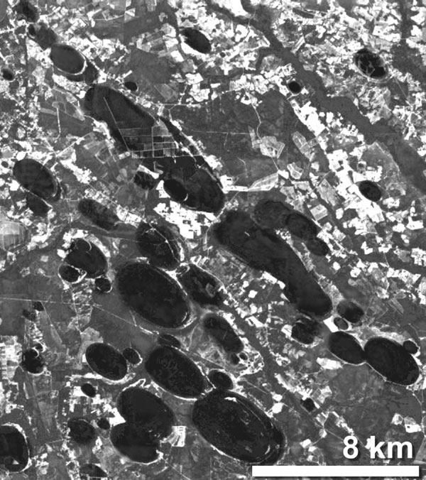
A more recent paper(e) by Antonio Zamora offers an important new concept, namely that the ‘bays’ were created by a meteorite striking the Laurentide Ice Sheet that existed in the Great Lakes region, during the last Ice Age, which in turn produced an enormous hail of ice ejecta which rained down on the eastern seaboard of what is now the United States. In his conclusion, he claims “that the new model of slow-velocity impacts from ice ejecta resulting from a meteorite impact on the Laurentide ice sheet explains many of the characteristics of the Carolina Bays, including the lack of shock metamorphism and meteorite fragments.” Zamora has also published an impressive LiDAR image of a section of the bays, which is best viewed on a large screen(o).
Zamora has also published in 2012 an ebook entitled Meteorite Cluster Impacts [1120](f), and in his 2015 book, Solving the Mystery of the Carolina Bays [1121], he expands on his theory that the ‘Bays’ were created as a result of an extraterrestrial impact with the Laurentide Ice Sheet. He describes in great detail the mathematical basis for his views.
Zamora has now had a new paper on the ‘Bays’ published in the peer-reviewed journal, Geomorphology(i), which may help to rekindle discussion on the subject. Although, in my opinion, they are not directly related to the Atlantis narrative, the existence of the Carolina Bays provides very obvious evidence of our catastrophic past.
Ralph Ellis believes that Zamora’s ‘blocks of ice’ ejecta created by the impact should be thought of instead as being more akin to softer ‘slushballs’(g)(h). Ellis noted that the inspiration for his papers relating to the Bays came from the work of geologist Michael Davias(t). Davias and his friend Tim Harris have been advocating the idea that Michigan’s Saginaw Bay holds evidence of an impact(u).
Robert W. Felix, an American architect totally rejects the ice ejecta theory, principally because the Laurentide Ice Sheet (LIS) should have disappeared before the creation of the Carolina Bays(l). However, conventional wisdom dates the decline of the LIS to around 9,600 BC(m), coincidental with the arrival of the Carolina Bats! Felix contends in one of his books [1688] that the Bays were formed by millions of gigantic explosions in the sky, explosions triggered by a magnetic reversal!
The serial sceptic, Paul Heinrich, claims(d) that there is dating evidence, which indicates varying dates for the creation of different Carolina Bays. The most recent popular work to discuss comprehensively, the origin as well as the conflicting dating evidence for the Carolinas, is The Cycle of Cosmic Catastrophes by Firestone, West and Warwick-Smith. This is an important book that is primarily concerned with a cosmic catastrophe that wiped out the North American mammoth along with other large animals at the same time that the Clovis People disappeared 13,000 years ago. This was also the time of the colder Younger Dryas period.

When the Russian investigator Leonard Kulik studied the Tunguska River area, over which a meteor/asteroid exploded in 1908, he discovered several neat oval bog holes that might offer support for either the impact theory or more improbably the theories of Pelletier.
Now, over a century after the Tunguska event, an Italian research team has concluded that it was an asteroid that struck the earth and that nearby Lake Cheko is the impact crater(c). However, this theory was debunked in 2017 by “researchers led by Denis Rogozin, from the Institute of Biophysics at the Siberian Branch of the Russian Academy of Sciences, carried out their own analysis and concluded that lake sediments were at least 280 to 390 years old, ‘significantly older than the 1908 Tunguska Event.’
And in a new study published May 2 in the journal Doklady Earth Sciences, Rogozin and colleagues presented more evidence to refute the idea Lake Cheko is the Tunguska asteroid’s impact site.”(z)
In 2013 Gernot Spielvogel co-authored Sonnenbomben[1582] in which it is suggested that the Tunguska event was caused by a solar plasma ‘bomb’! Even Nikola Tesla was blamed by some as the perpetrator of the Tunguska event(n).
However, although the impact theory does appear to have widespread support, there appears to be a move to look at a natural earthbound explanation. The U.S. Geological Survey is now identifying the Bays as ‘relict thermokarst lakes’(q).
Such suggestions have been excluded by Paul-Jürgen Hahn who is adamant that the bays were the result of a cometary impact with the Sargasso Sea and was also linked to the Atlantis story and the Pyramids and Sphinx! He gives the date of the impact as “12 March 9,337 BC (Greg.), 10:19 true local time in South Carolina, respectively 09:27 Bahamas time.”(y)
A 2020 article reviews the theories relating to the origin of the bays as well as the extraordinary biodiversity to be found within the bays(p).
Nevertheless, various other theories are still under investigation, including serious consideration of the possibility of an alien spaceship explosion!(j)
Charles O’Dale, a Canadian researcher who has studied impact craters across Canada also ventured south to investigate the Carolina Bays. In a 2022 paper, he includes a number of excerpts from a range of other commentators that highlight the principal details relating to the Bays that are still in contention ninety years after their first discovery(w).
>In 2024, David Anderson, a retired physician, offered another look at the mystery of the Carolina Bays and their creation at the time of the Younger Dryas. In a 2024 paper(ab) on Graham Hancock’s website he reviewed the work of Zamora and Firestone et al and concluded that both offered valuable information, but that some modification was required. However, Anderson saw the catastrophe that created the Bays in a global context, which resulted in his detailed study of the origins of the Hongshan Shui Jing glass and offers evidence to associate them with the Younger Dryas event. He digresses near the end with a suggestion on how the large stones used by megalith builders were moved, which he proposed was done using balloons filled with hydrogen or methane!<
(a) See: Archive 2042
(b) https://www.uc.edu/news/NR.asp?id=8625
(c) https://phys.org/news/2012-05-team-evidence-lake-cheko-impact.html
(d) See: https://atlantipedia.ie/samples/archive-2040/
(e) https://www.scientificpsychic.com/etc/carolina-bays/carolina-bays.html
(g) https://independent.academia.edu/ralphellis4 see (h)
(i) https://www.sciencedirect.com/science/article/pii/S0169555X16308479?np=y (abstract only)
(j) https://www.qconference-athens-2011.grazian-archive.com/aspacekeytotheri/rubtsov-paperx.pdf
(k) https://en.wikipedia.org/wiki/Carolina_bay
(l) Carpet bombing the Carolinas – Ice Age Now (archive.org)
(m) https://study.com/academy/lesson/laurentide-ice-sheet-facts-collapse-timeline.html
(n) https://theunredacted.com/the-tunguska-blast-teslas-death-ray/
(o) https://www.scientificpsychic.com/etc/carolina-bays/carolina-bays-image.html
(p) https://augustamagazine.com/2020/06/30/amazing-carolina-bays/
(q) https://earthobservatory.nasa.gov/images/147904/ice-age-carolinas
(r) The Comet that Struck the Carolinas Harper’s Monthly No.168, 1933. p 87
(s) https://www.jstor.org/stable/30084930
(t) http://cintos.org/index.html
(u) Saginaw Bay fingered by gravity data as ice impact feature – The Cosmic Tusk
(v) (99+) Arguments and Evidence Against a Younger Dryas Impact Event | Jennifer Marlon – Academia.edu
(w) https://craterexplorer.ca/carolina-bays-structure/
(x) The Carolina Bays: George Howard’s Original 1997 Web Essay – The Cosmic Tusk (archive.org)
(y) Die Datierung der Atlantis-Katastrophe (p-j-hahn.de)
(z) The biggest asteroid to hit Earth in recorded history vanished without a trace: How? | Live Science
(aa) https://archive.org/details/reportongeologyo00tuom/page/144/mode/2up [p.143-144]
Gateway to Atlantis
Gateway to Atlantis [072] by Andrew Collins is one of the better books on the subject. It is a fully indexed and referenced work that clearly indicates the effort and depth of research that went 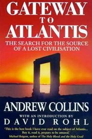 into producing it.
Collins was originally inclined to believe that the Antarctic had been the home to Atlantis but has gradually come to focus his attention on the Caribbean. He has trawled the classical writers for any possible reference to Atlantis and has concluded that all their considerable evidence points to the Atlantic and in particular the Caribbean as the location of Atlantis.
In order to explain the sudden destruction of Atlantis, Collins discusses the possibility of some kind of cometary or asteroidal impact being the culprit. He is inclined to see the Carolina Bays as remnants of this collision. His conclusions are closely mirrored by the views of Emilio Spedicato. More details can be found on Collin’s website(a).
Paul Jordan, an Atlantis sceptic, has written a critical review of Collins’s book in his Atlantis Syndrome[418] , part of which is now available online, spread over four papers(b).
>Another sceptic, Paul Heinrich, has also offered a critical review of ‘Gateway’ with particular reference to geological evidence offered by Collins(c). Collins and before him Otto Muck and later Hancock viewed the Carolina Bays as evidence of a possible civilisation destroying impact. Heinrich took a different view when he concluded that “In a detailed examination of the geologic evidence offered by Collins for a catastrophic meteorite or comet impact about 10,500-10,600 BP (8,500-8.600 BC), I found that none of the observations or data provide convincing evidence for such an event. In the case of the Carolina Bays, there is overwhelming evidence that these features formed tens of thousands of years before 10,500-10,600 BP. Thus it is impossible that these features could have been formed at the time proposed by Collins.” My problem is that Heinrich’s very ancient date for the ‘bays’ raises the question of how they are not eroded to a greater extent!<
(a) https://www.andrewcollins.com/
(b) https://web.archive.org/web/20211205075454/https://world-news-research.com/cgatlantis.html