Poverty Point
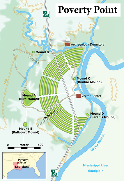
Poverty Point is an ancient site in north-eastern Louisiana with remarkable concentric ridges reminiscent of Plato’s description of Atlantis. Poverty Point is claimed as the remains of the oldest city in North America having been dated to around 1600 BC. Estimates have put the population of the city at 5-15,000 people at its greatest with two major influxes around 1600 and 1000 BC. It appears to have been suddenly abandoned and eventually covered with debris until it was discovered in 1950, when it was spotted from the air.
“The site is composed of some six C-shaped concentric ridges with each ring separated by a gulley. The ridges are all half circles. While the ridges range from 0.3 feet to 6 feet, they would have been much higher in the past as they have worn down over the many years. Much of the geometric design is hard to make out today on the ground, the scale and geometric design of the site only became apparent after aerial photographs were taken.“(e)
The purpose of the site is unknown, although various theories are put forward on a regular basis, one of which is that it was used as the world’s largest solstice marker(b)!
Frank Joseph suggests a definite link with the Atlanteans, claiming [0104.229] that “the site is fundamentally a mirror-image of Plato’s description of Atlantis, an identification reaffirmed by sudden cultural florescence at Poverty Point in 1200 BC, just when Atlantis was finally destroyed, and some of its survivors sought refuge in what is now America.”
The late Professor Antonis Kontaratos went further when he presented three papers [750.237] to the 2008 Atlantis Conference in Athens in which he expressed strong support for the American Hypothesis and that Poverty Point had been the capital of Plato’s Atlantis.
Gavin Menzies claimed [780.290] that Poverty Point was actually where the Minoans processed copper brought down the Mississippi from Michigan before transporting it back to the Mediterranean to feed the Bronze industries there! J.S. Wakefield expressed similar ideas, in great detail, in a 2015 article(d).
 It has also been suggested that the mounds of prehistoric Louisiana, including those at Poverty Point, were constructed as a protection against seasonal flooding!
Poverty Point has now been designated a UNESCO World Heritage Site of which there are less than 1,000 worldwide and only 24 in the United States (2019)(f). It also has an official website(h).
The results of a study of Mound A, published in the January 2013 edition of Geoarchaeology, have revealed that the structure was built in 90 days or less(a).
An extensive paper from 1996 by Jon L. Gibson is available online(c).
Dr Diana Greenlee of the University of Louisiana Monroe and station archaeologist at Poverty Point was involved in recent research that shows Poverty Point to be more complex than previously believed. Thanks to a 2019 Preservation Technology and Training Grant from the National Park Service, ULM and Minnesota State University Moorhead were able to use radar to send electromagnetic pulses into the earth, helping shed light on what lies below and between the mounds and ridges. What they discovered was a new ridge hidden underground and more information about the creation of the site(g).
Work continues at the site.
(b) https://www.messagetoeagle.com/is-the-poverty-point-octagon-worlds-largest-ancient-solstice-marker/
(c) Louisiana Archaeology Poverty Point Anthropological Study Series (archive.org)
(e) The History Of Poverty Point: One Of America’s Oldest Archeological Sites (thetravel.com)
(f) https://en.wikipedia.org/wiki/List_of_World_Heritage_Sites_in_the_United_States
(h) https://www.povertypoint.us/ *
