Maria Reiche
Nazca
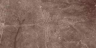
The Nazca Lines of Peru were systematically studied by Toribio Mejia Xesspe, a Peruvian archaeologist, beginning in 1926, but the geoglyphs only gained widespread attention when pilots flew over them in the 1930s.
 Paul Kosok (1896-1959) was also claimed as the first to carry out a professional study of the Nazca drawing in 1939. He was assisted a year later by Maria Reiche (1903-1998) who devoted the rest of her life to the study of Nazca. Kosok continued his research there until 1949.
The purpose of the geoglyphs has generated reams of commentary, from the nonsensical of von Däniken to the more profound of Reiche.
“In the late 1960s and early 1970s, however, other researchers, including American astronomer Gerald Hawkins, examined the Nazca Lines and disagreed with the astronomical explanation for the geoglyphs. They also poked holes in other far-out explanations, such as those relating to aliens or ancient astronauts(f).”
However, for sheer complexity, I must direct you to the work of Czech-Canadian Jiri Mruzek. He has managed to link the Monkey geoglyph at Nazca with the layout of the Giza pyramids and a 14,000-year-old cave drawing at La Marche in France; all under the banner of ‘Seal of Atlantis’!!!(a)
In 2018, it was announced that another fifty Nazca-style geoglyphs had been discovered in the adjacent province of Palpa(b). This number was subsequently increased to 142(c).>This number continues to grow, with a suggestion that many more will follow(g).<
In February 2020, Frank Maglione Nicholson, Ken Phungrasamee & David Grimason, collectively known as The Nazca Group(d), published The Nazca Great Circle Map Hypothesis. Their claim is that “The lines and geoglyphs carved into the Nazca plateau represent a map of the Earth. The map is a Great Circle Map: a gnomonic projection with the center of the Earth as its cartographic viewpoint. Each line on the Nazca Plateau represents a great circle of navigation centered at the center of the Earth and encircling the entire planet. The majority of the lines on the Nazca Plateau radiate from five loci of origin called radial centers.”
Another 2020 article(e) by Laszlo Arvay concluded that “the Nazca Plateau could be the largest astronomical atlas in the world. If that is so, Paul Kosok was right after all and on a much greater scale than he ever thought possible.”
>Robert Schoch has produced a novel explanation for the design of the Nazca geoglyphs by comparing them to elements of the Easter Island rongorongo script. Schoch’s theory is that they are a record of coronal mass ejections from the sun around 9700 BC that devastated our planet with electrical discharges, the triggering of seismic and volcanic activity as well as the ending of the Ice Age with its consequent floods. Not unexpectedly, Jason Colavito found such ideas totally unacceptable and said so in a 2012 blog(h).<
(b) https://www.dailygrail.com/2018/04/more-than-50-new-nazca-lines-discovered-in-peruvian-desert/
(c) https://www.dailygrail.com/2019/11/more-than-140-new-nazca-lines-discovered/
(d) https://nazcasolution.com/
(e) https://www.bibliotecapleyades.net/archivos_pdf/skies-above-nazca.pdf
(h) Rongorongo A-Go-Go: Robert Schoch’s 12,000-Year Easter Island Delusion – JASON COLAVITO *
