Latest News

Joining The Dots
I have now published my new book, Joining The Dots, which offers a fresh look at the Atlantis mystery. I have addressed the critical questions of when, where and who, using Plato’s own words, tempered with some critical thinking and a modicum of common sense.Read More »
Solar Boats
Ancient Seafaring
Ancient Seafaring is a controversial subject owing principally to a dearth of physical evidence. The earliest known boat is the Pesse
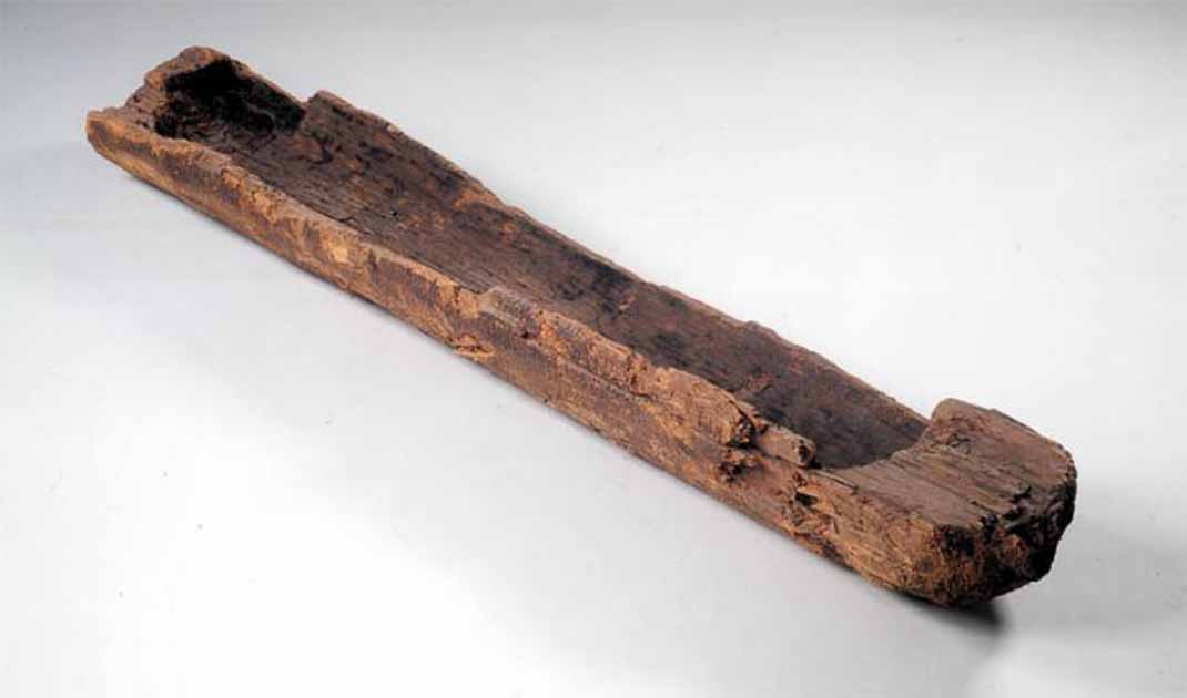
Pesse Canoe
Canoe (see right), which was discovered in The Netherlands and is thought to be around 10,000 years old. The second-oldest boat was also a canoe, found in Malawi and dated to about 8,000 years ago(g). Wikipedia lists all the surviving boats, which shows that until the third millennium BC all that have been found are canoes.
Seafaring and Atlantis are inextricably linked. In Critias 117d Plato anachronistically refers to the shipyards of Atlantis being full of triremes, which were not developed until the 7th century BC, long after the demise of Atlantis. However, the term ‘trireme’ was probably employed by Plato to make his narrative more relevant to his audience. He credits the Atlantean navy with 1200 ships, which for me seems like borrowing and rounding the numbers of either the Achaean fleet of 1186 vessels in Homer’s Iliad or that of the 1207 ships of the later Persian invaders. That ships were used in the war with Athens can be inferred from the fact that Atlantis, or at least its capital, was situated on an island.
Professor Seán McGrail (1928-2021) wrote in his monumental work, Boats of the World, “There is no direct evidence for water transport until the Mesolithic even in the most favoured regions, and it is not until the Bronze Age that vessels other than logboats are known” [1949.10]. For those that adhere to a 10th millennium BC date for the Atlantean War with Athens, this lack of naval evidence to support such an early date undermines the idea. An invasion fleet of canoes travelling from beyond the Pillars of Herakles to attack Athens seems rather unlikely!

Khufu Boat
Apart from the Solar Boats of the Egyptians, such as the Khufu Boat (see left), discovered at Giza in 1954 and dated to 2500 BC. Fifty years later Kathryn A. Bard, Professor Emerita of Archaeology and Classical Studies at Boston University and Rodolfo Fattovich, an archaeologist at the Orientale University of Naples, discovered an ancient port at Mersa Gawasis on the Red Sea. Evidence at the site indicated that it had been used around 1800 BC as an embarcation point for expeditions to the legendary land of Punt. Andrew Curry has written a review(l) of the work carried on at the site. Curry’s article is headed with the claim that the discovery of the harbour “proves ancient Egyptians mastered oceangoing technology”. In my opinion, this is possibly overstating it as the remains of the vessels found there may have suited the relatively calm Red Sea, a voyage in the Atlantic would probably have been too much.
Nevertheless, Heather Pringle published an article in 2008 in which she reviewed the suggestion by Jon Erlandson(k), an archaeologist at the University of Oregon, that early humans may have travelled the oceans 70,000 years ago(j).
Seldom referred to, but perhaps an even more interesting detail is to be found earlier in Critias 113e which describes the mythological beginnings of Atlantis and which reads “for at that time neither ships nor sailing were as yet in existence”. However, we are given little information to bridge the time up to its development as a major trading entity. It is reasonable to assume a gap of several thousand years.
Recent studies(a) have suggested that primitive seafaring took place in the Mediterranean thousands of years earlier than originally thought and may even have been engaged in by Homo Erectus and Neanderthals in the form of island hopping and coastal-hugging, the latter continuing into historical times.
Plato describes an advanced maritime trading nation with a powerful naval capacity. How much was part of the original story brought from Egypt by Solon, or whether it was in any way embellished by Plato, is unclear. The earliest known trading empire is that of the Minoans which began in the 3rd millennium BC and has led to many identifying them with the Atlanteans. However, there are very many other details in Plato’s narrative that seriously conflict with this hypothesis.
The limitations of ancient seafaring raise many questions regarding the navigation supports available to these early sailors(b). Initially, sailing, probably for fishing, would have been confined to daytime travel and keeping within the sight of land. With the development of maritime trade, the demand for improved navigation methods also grew.
It has been generally accepted that sailing in the Mediterranean in the Middle Ages was not undertaken between October and March because of the dangerous weather usually encountered at that time of the year. Some cities, such as Pisa, Venice and Genoa, had ordinances forbidding commercial voyages in winter! Understandably, many considered that this was also the case in Greek and Roman times, when shipbuilding skills and navigational technology were probably more primitive. A 2015 paper by T.M.P. Duggan demonstrates that commercial maritime activity in winter was commonplace in medieval times(m).
In time, sailors acquired a familiarity with the night sky that enabled them to use the stars as navigational aids, given clear skies. Gradually, as nighttime travel became more common, the use of beacons and later lighthouses also expanded. The lighthouse at Pharos near Alexandria came to be counted as one of the wonders of the Old World. Similarly, it is thought that the Colossus at Rhodes performed a similar function.
Different navigation skills have been identified in different parts of the world. In the Pacific, the navigational capabilities of the Polynesians are legendary(c). A November article on the BBC website expanded on this ‘ancient art of wayfindlng’ (i). The ancient Chinese employed magnetism(e) and in the cloudy North Atlantic, the Vikings used their ‘sunstones’(d).
In their book, Atlantis in America [244] Ivar Zapp & George Erikson claimed that the stone spheres of Costa Rica had a navigational function [p34] as Zapp discovered that the sightlines of all the stones remaining in their original positions pointed to important ancient sites such as Giza, Stonehenge and Easter Island!
A most imaginative proposal has come from Crichton E.M. Miller, who proposed [1918] that the ubiquitous Celtic Cross is an image of an ancient navigational device. He further claims that “This instrument can tell the time, find latitude and longitude, measure the angles of the stars, predict the solstices and equinoxes and measure the precession of the equinoxes. It can also find the ecliptic pole as well as the north and south poles; it can make maps and charts, design pyramids and henges and—used in combination with these sites—can record and predict the cycles of nature and time(f) “. Then, for good measure, he proceeded to patent the device.
(a) Ancient Mariners: Did Neanderthals Sail to Mediterranean? | Live Science
(b) http://www.ancient-wisdom.com/navigation.htm
(c) https://en.wikipedia.org/wiki/Polynesian_navigation
(d) https://www.newscientist.com/article/dn20052-vikings-crystal-clear-method-of-navigation/
(e) http://www.ancient-wisdom.com/magnetism.htm
(f) Atlantis Rising magazine #35 http://pdfarchive.info/index.php?pages/At
(g) https://www.ancient-origins.net/artifacts-ancient-technology/pesse-canoe-0017298
(i) (BBC Nov 29, 2023) https://www.bbc.com/future/article/20231128-what-we-can-learn-from-the-ancient-art-of-wayfinding
(j) https://www.discovermagazine.com/the-sciences/did-humans-colonize-the-world-by-boat