Latest News

Joining The Dots
I have now published my new book, Joining The Dots, which offers a fresh look at the Atlantis mystery. I have addressed the critical questions of when, where and who, using Plato’s own words, tempered with some critical thinking and a modicum of common sense.Read More »
Joseph P. Skipper
Skipper, Joseph P.
Joseph P. Skipper has devoted a number of years to the study of apparent Mars anomalies as seen on Google images. His interest in satellite imagery led him to a review of images of a number of sites in the Atlantic that appear to show features on the sea floor that are too regular in shape to be considered natural. These are located off the west coast of Ireland. A close look at the image used by Skipper shows what appears to be striations, which run east – west and look exactly the same whether they run over higher or lower sections of the seafloor. They also cover an area greater in size than the British Isles and so cannot be streets. The lines shown would indicate ‘streets’ many kilometres wide! 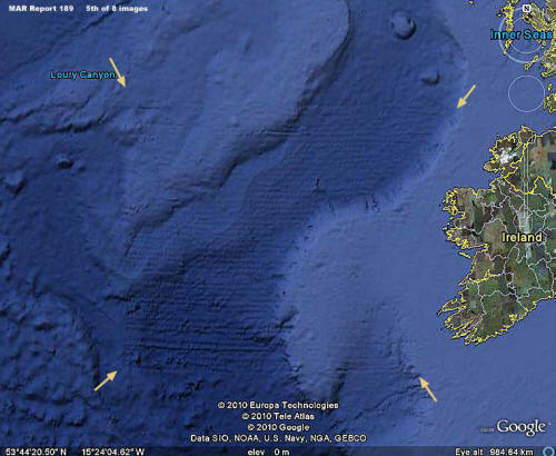
Google’s explanation that these are the result of some sort of sonar glitch is not accepted by Skipper. This might be a valid view to hold, but his additional claim that other images show what he considers to be ancient writing on the ocean bed, inscribed on a gigantic scale, does little to portray him as a rational commentator.
Skipper’s review of the Atlantis narrative is fairly standard(a), placing Atlantis in the Atlantic and probably established during the last Ice Age.
(a) https://www.bibliotecapleyades.net/atlantida_mu/esp_atlantida_35.htm
Satellite Imagery
Satellite Imagery has recently been introduced into the Atlantis search with a variety of location claims based on features visible from space. These assertions include Albania (2007), Andalusia, Spain (2003), Cyrenaica, Libya (2005) and Sherbro Island, Sierra Leone (2007). All such claims must necessarily be treated with extreme caution unless substantiated by archaeology on the ground (or underwater). At best, only one of the sites listed here can be correct and probably all are not, since Atlantis is supposed to have been submerged and so not yet readily visible to the scrutiny of our current aerial mapping technology.
A number of satellite images showing underwater anomalies have been claimed as evidence of Atlantis, but so far all have been shown to be the result of faulty data gathering and/or defective analysis of the data.
In 2010, there was a claim that Atlantis had been located using satellite imagery that placed it underwater between Bermuda and the Bahamas.
One of the most extreme claims based on images has come from Joseph P.Skipper, who has identified some seafloor markings as an ancient script, apparently ignoring the fact that the lines of the writing would probably have to be a mile in width!
Skipper also promoted the rectangular Google Earth images of the Atlantic, west of Gibraltar, as the enormous ruins of manmade structures(c). Others claimed that the lines were ‘streets’. When Google explained that the images were a consequence of flawed data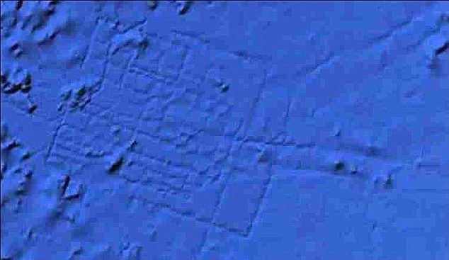 processing, cries of ‘cover up’ could be heard. In the end, people believe what they want to believe.
In April 3, 2018, British tabloids regurgitated the same flawed images under the familiar ‘Atlantis FOUND’ headline, this time crediting Blake Cousins as the ‘discoverer’(d).
In July 2021, I was sent a number of images that purported to show anomalous underwater images in the Central Mediterranean northeast of Malta. At first sight, they appeared to show extensive manmade features. However, further investigation eventually revealed that the images were the consequence of the flawed computer interpretation of sonar data. In December 2021, Luigi Usai produced (a)(b) the same flawed imagery as evidence that he had discovered a lost submerged civilisation!
(a) Why didn’t scientists find Atlantis before Usai Luigi? ? Atlantis found!
(c) Ancient Atlantis or Another? (bibliotecapleyades.net)