Latest News

Joining The Dots
I have now published my new book, Joining The Dots, which offers a fresh look at the Atlantis mystery. I have addressed the critical questions of when, where and who, using Plato’s own words, tempered with some critical thinking and a modicum of common sense.Read More »
Google Earth
Bamford, Bernie
Bernie Bamford, a British aeronautical engineer, got his 15 minutes of fame in 2009 when he reported rectangular images, the size of Wales, on the seafloor 620 miles off the west coast of Africa while browsing Google Earth(a). The images were widely shared on the internet. However, it is claimed that these features were discovered even earlier by Larkin & Cynthia Jones(b).
Google responded,“that the image is merely an artefact of the data collection process, not the city of Atlantis.”
If the lines represented walls or streets, they would have to be a number of kilometres thick or wide, which is not compatible with a city.
A number of satellite images showing underwater anomalies have been claimed as evidence of Atlantis, but so far, all have been shown to be the result of faulty data gathering and/or defective analysis of the data.
In July 2021, I was sent a number of images that purported to show anomalous underwater images in the Central Mediterranean, northeast of Malta. At first sight, they appeared to show extensive manmade features. However, further investigation eventually revealed that the images were the consequence of the flawed computer interpretation of sonar data. In December 2021, Luigi Usai produced the same flawed imagery as evidence that he had discovered a lost submerged civilisation!
(a) https://thenextweb.com/news/google-earth-helped-discover-lost-city-atlantis
(b) Atlantis – Just Another Sea Floor Anomaly? – YouTube
Jaye, Michael
Michael Jaye is an Associate professor at the Naval Postgraduate School, in Monterey, California. He is a  confirmed catastrophist focused on cometary impacts. In a lecture to the Geological Society of America in 2011(a) he describes two major events in the Earth’s history that had profound effects on the earth and life on it. The first was a double impact 65 million years ago and is generally accepted to have led to the demise of the dinosaurs and the second 460,000 years ago.
In an April 2015 lecture entitled Resolving the Problem of Atlantis, he expands on his original ideas(b) introducing a third event 13,000 years ago when another cometary impact brought an enormous amount of water to earth, which linked together previously disconnected seas and oceans.
At this point, he introduces Atlantis or more correctly the alleged Google image of Atlantis in the Atlantic Ocean that Jaye now claims was the Plain of Atlantis. As I have previously stated, the image in question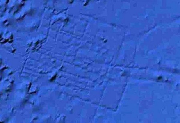 shows lines that would have been kilometres in width and could not have been streets and so are also too wide to have been the irrigation ditches described by Plato. The U.S. National Oceanic and Atmospheric Administration has also debunked the silly Atlantis claims generated by these images(e). However, the problem remains, that some people believe what they want to believe not what can be demonstrated.
Jaye does not accept the explanation for these anomalous lines given by Google, joining conspiracy theorists in the process. I personally think that he should stick to geology and leave the subject of Atlantis to others.
Jaye has also given me a link(c) to a video of one of his lectures. In it, one of his claims is that most of the Earth’s water is the result of a collision with an icy comet around 12,800 years ago. However, the widespread distribution of fossil fish far exceeds the areas occupied by original unconnected bodies of water suggested by Jaye. This is just one of many inaccuracies offered by him. His ideas can be read on Graham Hancock’s website(d) and in his slender 2017 66-page book, The Worldwide Flood [1549].
Jaye has failed to explain how his claim of a relatively recent acquisition by the Earth of most of its water, can account for the recurring Ice Ages that our planet has endured over many millions of years. Ice Age theory is well established, but according to him, the Earth would not have had enough water over that timespan to produce the glaciers that enveloped large areas of the globe, sometimes to a depth of 3 or 4 km, leading to the measurable isostatic rebound we still experience today.>>Incidentally, where I’m sitting right now had a glacier of around a kilometre thick overhead during the last Ice Age and is thought to be the last part of Ireland to be deglaciated.<<
!
Jaye also published a paper entitled Mu and the Worldwide Flood, in which he found some support for the late Flood theory.(g)
Carl Feagans, an ardent sceptic, has published a lengthy refutation of Jaye’s theories, in particular his idea of a global flood.(f)
(b) The Explorers Club – Events – NYC – Public Lecture Series feat. Michael Jaye (archive.org)
(c) https://vimeo.com/126026401
(d) https://grahamhancock.com/jayem2/
(e) https://oceanservice.noaa.gov/facts/atlantis.html
(f) https://ahotcupofjoe.net/2019/11/the-pseudoarchaeology-of-michael-jayes-worldwide-flood/
(g) Mu and the Worldwide Flood | My-Mu.com Guest Blog (archive.org)
Underwater Anomalies
Underwater Anomalies claimed as Atlantis related have been ‘identified’ in recent years on various Google Earth  images. The one that received the most widespread attention was situated in the Atlantic west of the Canaries. Bernie Bamford, a British aeronautical engineer, got widespread media coverage in 2009 with this ‘new’ discovery. However, it is claimed that these features were discovered even earlier by Larkin & Cynthia Jones(h).
The location in question purports to show a gridlike street system. However, the scale involved would suggest ‘streets’ half a mile wide, which even for Atlanteans would have been rather unlikely. Google updated its data with a technical explanation for the anomaly(b)(k). However, Michael Jaye is unwilling to accept Google’s response and has described the gridlike feature to have been the Plain of Atlantis(f). A comparable site(c) near Puerto Rico has been highlighted by Deb Johnson, which can probably be explained similarly.
Bernhard Beier wrote an extensive article for Atlantisforschung on the evolution of the controversy surrounding Bamford’s claim and concluded with “In this case, the Atlantis reference was created solely by the media, which acted completely independently of competence – and thus created another, small ‘Atlantis myth’ in the world.”(j)
A slightly different type of image has been spotted in lakes in the Peruvian Andes(d) as well as Manzanillo Bay in the Dominican Republic(e). These images of shallower waters show a range of rectangular shapes that stop dead where they meet the shore with no continuation on land. Once again I suspect flawed processing of the scanning data.
Apart from the fact that all of the above lack any of the circular features so vividly described by Plato. It is obvious that they cannot all be Atlantis and in all probability none are. No effort has been made to match any of these anomalous images with the topographical details provided by Plato!
May 2022 saw more nonsense of this ilk in the tabloids, with headlines proclaiming the discovery of a ‘Yellow Brick Road to Atlantis’, north of Hawaii in the Pacific. In fact, the ‘road’ is a recognised volcanic feature and has never been claimed as anything else by its discoverers(i).
In a similar manner, it was reported in 2011 that divers on the coast of the Greek island of Zakynthos initially thought that they had discovered the remains of a lost port city, when they found “some very unusual underwater formations came into view, including some strange pillars, walkways and even what appeared to be courtyards. Writing in the journal Marine and Petroleum Geology, a team of environmental researchers has now revealed that these peculiar structures are not actually archaeological remains at all.
After being carefully examined by archaeologists, geologists and professional divers from both Greece and the United Kingdom, it was clear that the disk and doughnut-shaped columnar features were a type of mineralization feature. They were being generated by the escape of chemicals, mainly methane, emerging from hydrocarbon-rich layers hiding below a semi-ruptured fault.
Microbes lurking in the sediment there appeared to be using the carbon in the methane as a source of energy. As they oxidized the methane, these bacteria and archaea were inadvertently changing the chemistry of the sediment they were living in to form a natural cement. To geologists, this is known as ‘concretion,’ and it can result in a number of new rock formations.” (l)
(b) https://www.livescience.com/18308-google-earth-update-erases-atlantis.html
(c) https://www.atlantismystery.com/Atlantis.jpg (offline)
(d) https://www.bibliotecapleyades.net/sociopolitica/esp_sociopol_underground23.htm
(e) https://manzanillodigital.blogspot.com/2009/12/lo-que-dice-fianchy-torres-sobre.html
(f) The Explorers Club – Events – NYC – Public Lecture Series feat. Michael Jaye (archive.org)
(g) http://web.archive.org/web/20220526204732/https://skeptico.blogs.com/skeptico/2009/02/atlantis-not-found-with-google-earth.html
(h) Atlantis – Just Another Sea Floor Anomaly? – YouTube
(k) Atlantis revealed at last… or just a load of old Googles? | Daily Mail Online
(l) https://www.iflscience.com/submerged-greek-lost-city-sculpted-microbial-life-36128
Cape Verde Islands
The Cape Verde Islands are located on the continental shelf off the west coast of Africa and are a popular location for Europeans wishing to buy property in the sun. They would have been more extensive in area when the ocean levels were lower during the last Ice Age . Along with the Canaries, Azores, Madeira and some smaller North Atlantic islands, they constitute ‘Macaronesia’.
When they were rediscovered in 1460, they were found to be uninhabited, although they were noted as inhabited on earlier maps.  The 1413 map of the Catalan cartographer Mecia de Viladestes, which is thought to be based on Roman sources, shows islands at the same location named as Gades, a name that could be a diminutive of Gorgades or possibly derived from Gaderia, one of the kingdoms of the Atlantis empire. In the 16th century the Cape Verde Islands were also shown with the alternative name of Dorcades, on the 1563 map of the Portuguese historian Antonio Galvao, which may just have been a corruption of Gorgades. A few years later, in 1587, a map by the English geographer Richard Haklyut again applies the name Gorgades to the Cape Verde Islands. The identification of the Gorgades with the Cape Verde Islands is strongly defended by modern writers, such as Andrew Collins.
Although there is little support for identifying the Cape Verde Islands as Atlantis itself, there is willingness by some to see them as remnants of its empire. Without more clear-cut classical references and/or archaeological evidence, it would be unwise to put too much value on any Atlantean link with the archipelago.
Thomas K. Dietrich speculated[217, p70] that the Prime Meridian of ancient civilisations was centred on the Cape Verde Islands.
In 1949, Capt. H.P.C. Andersen, who worked for a Danish salvage company, wrote a very brief letter to Egerton Sykes‘ Atlantis Research journal, with the self-explanatory title of Atlantean Traces in the Cape Verde Islands(a). In it, he recounts coming across a harbour in Boavista Island, the bottom of which was completely covered in sheets of concrete about a yard square, reminiscent of a market place.
One site claims that the Cape Verde Islands are half-way between Machu Picchu and the Great Pyramid, as well as half-way between Easter Island and the Indus Valley! However, the Indus Valley stretches over 1500 km, making the latter claim rather ‘iffy’, in fact, all are out by hundreds of kilometres.(c)
A short YouTube clip(b) purporting to offer evidence for Atlantis at Cape Verde is available. It is based on Google Earth images, but is far from convincing.
(a) Atlantis Research (1949. 2.1. p13)
(b) https://www.youtube.com/watch?v=YDE__VnJvBA (No longer available)
(c) Untitled Document (hiwaay.net)
Satellite Imagery
Satellite Imagery has recently been introduced into the Atlantis search with a variety of location claims based on features visible from space. These assertions include Albania (2007), Andalusia, Spain (2003), Cyrenaica, Libya (2005) and Sherbro Island, Sierra Leone (2007). All such claims must, of necessity, be treated with extreme caution unless substantiated by archaeology on the ground (or underwater). At best, only one of the sites listed here can be correct and probably all are not, since Atlantis is supposed to have been submerged and so not yet readily visible to the scrutiny of our current aerial mapping technology.
A number of satellite images showing underwater anomalies have been claimed as evidence of Atlantis, but so far all have been shown to be the result of faulty data gathering and/or defective analysis of the data.
In 2010 there was a claim that Atlantis had been located using satellite imagery that placed it underwater between Bermuda and the Bahamas.
One of the most extreme claims based on images has come from Joseph P.Skipper who has identified some seafloor markings as an ancient script, apparently ignoring the fact that the lines of the writing would probably have to be a mile in width!
Skipper also promoted the rectangular Google Earth images of the Atlantic, west of Gibraltar as the enormous ruins of manmade structures(c). Others claimed that the lines were ‘streets’. When Google explained that the images were a consequence of flawed data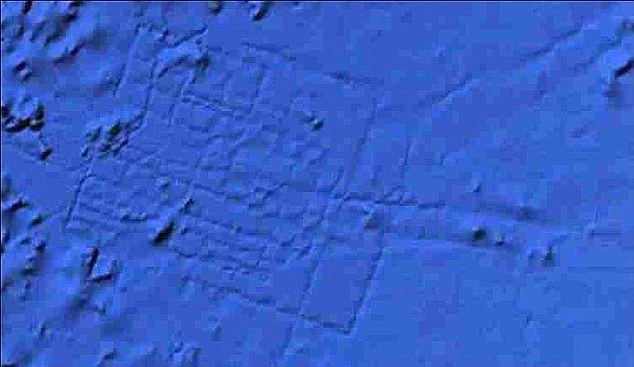 processing cries of ‘cover up’ could be heard. In the end, people believe what they want to believe.
In April 3, 2018, British tabloids regurgitated the same flawed images under the familiar ‘Atlantis FOUND’ headline, this time crediting Blake Cousins as the ‘discoverer’(d).
In July 2021 I was sent a number of images that purported to show anomalous underwater images in the Central Mediterranean northeast of Malta. At first sight, they appeared to show extensive manmade features. However, further investigation eventually revealed that the images were the consequence of the flawed computer interpretation of sonar data. In December 2021 Luigi Usai produced (a)(b) the same flawed imagery as evidence that he had discovered a lost submerged civilisation!
(a) Why didn’t scientists find Atlantis before Usai Luigi? ? Atlantis found!
(c) Ancient Atlantis or Another? (bibliotecapleyades.net)