Latest News

Joining The Dots
I have now published my new book, Joining The Dots, which offers a fresh look at the Atlantis mystery. I have addressed the critical questions of when, where and who, using Plato’s own words, tempered with some critical thinking and a modicum of common sense.Read More »
satellite imagery
Morrison, Tony
Tony Morrison is probably best known for his definitive work on the Nazca Lines, Pathways to the Gods[1036]. Tony and Marion Morrison have developed the South American Pictures.com website in order to show their extensive life’swork. Unfortunately, the southamericanpictures website went offline, but now, many of the image collections have been reassembled and are again available online(b).
In 1998, Morrison published a number of papers, provocatively entitled The Bolivian Atlantis(b-e). They cover familiar territory – Tiwanaku, Pumapunku, Posnansky, Bellamy, Fawcett, Sykes, Blashford-Snell. This was the same year that Jim Allen published his Atlantis: The Andes Solution[877]. Had Allen not done so, I suspect that Morrison might have produced a more detailed book himself, as apparently he and a colleague, Mark Howell, had built up quite a dossier on the subject.
Surprisingly, Morrison did not mention the mysterious puquios of the Nazca region(f), which, with the aid of satellite imagery(g), have been shown to have been part of a sophisticated hydraulic system that supplied water to an extremely arid locality.
(a) https://nonesuchexpeditions.com/south-american-pictures/sap-archaeology-history-index.htm
(b) https://www.nonesuchexpeditions.com/South-American-Pictures/sap-archaeology-history-index.htm
(f) https://www.flickriver.com/photos/tags/puquios/interesting/
(g) (BBC April 8, 2016) https://www.bbc.com/future/story/20160408-the-ancient-peruvian-mystery-solved-from-space
Fisher, Mel
Mel Fisher (1922-1998) was colourful treasure hunter who claimed that he had discovered Atlantis in the Caribbean, but never revealed its location. He ran  a tourist shop in Key West where he also sold ancient gold coins. Unfortunately, shortly before his death, he was accused of minting some of the coins himself, which he denied. However, it adds to probability that his Atlantis story was also manufactured. Mel’s grandson, Sean, has also taken up salvaging and with regard to Atlantis, is reported as saying, “It was always my grandfather’s dream to find Atlantis.” Sean Fisher says. “I’m serious. We have some idea where it is. But it’s a hard salvage operation that will cost a lot of money and resources.”
Andrew Collins has told us[0072.333] of a number of telephone conversations that he had with Fisher shortly before his death, in which he claimed to have initially discovered Atlantis using satellite imagery. He also claimed to have subsequently verified his discovery using sonar scans not far from Cuba.
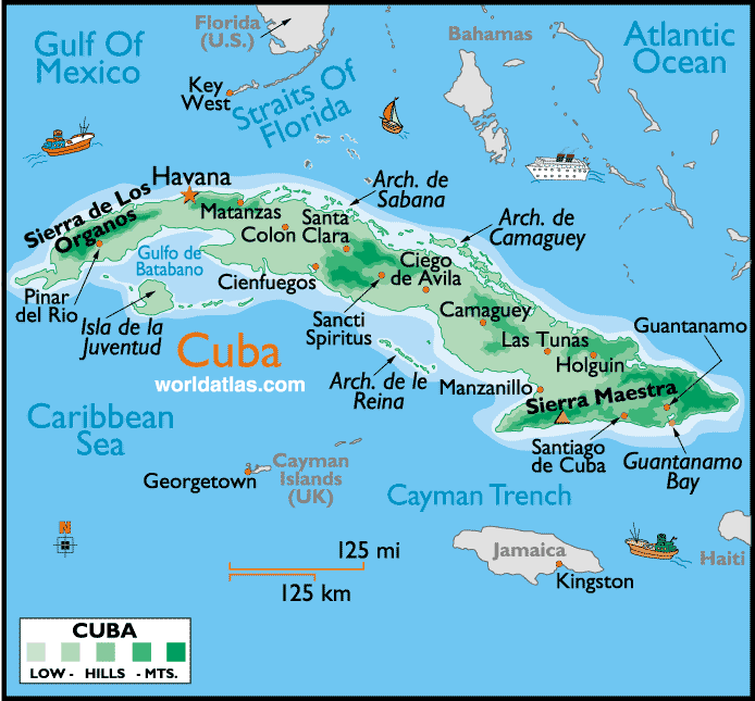
Cuba
Cuba is a Caribbean island favoured by some as a serious contender for the location of Atlantis.
” A two-page article appeared in the February 1952 edition of the magazine ECOS entitled ’Formó Cuba Parte de la Atlándida?’. Written by Francisco Garcia-Juarez, the press secretary of the Instituto Cubano de Arqueologia (Institute of Cuban Archaeology, or ICA) it posed the question: did Cuba once form part of Atlantis? He explained how members of the Institute were investigating the idea that traces of an Atlantean culture might be found in Cuba and Hispaniola.” This study had been prompted by a suggestion from Egerton Sykes(e).
Some years ago, Leicester Hemingway, the brother of Ernest, claimed to have spotted off the northern coast of Cuba “an expanse of stone ruins, several acres in area”.
 In more recent years, it was reported that Paulina Zelitsky and her team of underwater explorers found formations, in 2000 feet of water off the western tip of Cuba that resembled submerged cities.
Although there was a widespread media reaction to Zelitsky’s discovery, many commentators drew parallels with Plato’s city of Atlantis. However, Zelitsky was unwilling to make such comparisons. The story is a myth, said Zelitsky. “What we have found is more likely remnants of a local culture”, once located on a 100-mile “land bridge” that joined Mexico’s Yucatan Peninsula with Cuba.
Although further explorations were planned, it is reported that the U.S. government applied pressure to have any further funding denied. May 2013, had Zelitsky trying to revive interest in her theories in an interview with Luis Mariano Fernandez(d). However, in 2012, Andrew Collins offered a different account of the Zelitsky funding difficulties(g).
Barry Warmkessel, who is normally just concerned with the threat to Earth posed by asteroids and comets, digressed slightly in an illustrated paper updated in 2015(l). He discusses in great detail the possible destruction of Atlantis by a comet/asteroid impact off the west coast of Cuba.
Andrew Collins is probably the best-known supporter of a Cuban Atlantis. His book[072] and website(a) list eleven points in favour of this theory. He contends that Cuba’s western plain, which stretches from Havana westwards to Pinar del Rio was the great Plain of Atlantis described by Plato. He believes that the main city was located near the present Isle of Youth (Isla de la Juventud) situated in the south of the island. In 2009 Norman Frey wrote a paper(b) supporting the Gulf of Batabanó which lies north of the Isle of Youth as Atlantis’ location at the end of the last Ice Age. He supports his contention with satellite images and the work of Dr Christine Pellech. Frey also claims that the two plains of Cuba match Plato’s description of the Plain of Atlantis(k).
A.R.E. is also a supporter of Cuba as a possible location for the capital of Atlantis. They have suggested an underwater ‘island’ at Zapata, located on the southern side of Cuba, north of the Isle of Youth and just to the west of the infamous Bay of Pigs. This ‘island’ is surrounded by a small ring of water and is about 7 miles in diameter, consistent with Plato’s description of the outer ring of Atlantis. A.R.E.’s Greg Little, obtained old depth and bottom contour charts of the site and found that the island was comprised of a series of rings. Little also identified other features in the locality that match Plato’s story; ancient manmade canals north of the underwater island. These canals have been attributed to the Taino Culture, a mound-builder culture present in Cuba about 3,000 years ago, that became extinct shortly after the Spanish conquest. Further north there is a mountain range enclosing the area with a wide river running at its base — a further match with Plato. Little also found that the centre of the underwater island is not only the tallest portion, but also has several springs on it.
One completely off-the-wall suggestion has been that the Cuban Missile Crisis was instigated to prevent the Soviets from finding Atlantis(f)!!
A project to compile an archaeological Atlas of Cuba has so far identified over 3,000 pre-Columbian sites. Cuba’s westernmost province, Pinar del Rio and the central region of Villa Clara, have the highest density of sites, with 500 each(c).
Gerard W.J. Janssen of Leiden University places the voyages of Odysseus in the Atlantic(i). However, although he situates most of the places visited in the eastern Atlantic he does claim(h) that Homer‘s Laestrygonians were to be found in Cuba, an interpretation supported by both Théophile Cailleux and Iman Wilkens.
Luigi Usai has recently (2022) published a number of images purporting to show underwater anomalies off the coast of Cuba(j). As Usai has already designated the central region of the Mediterranean as the location of Atlantis, I cannot understand his reason for showing such images. Similar anomalies have been found in various parts of the world when underwater mapping has taken place and explained by Google as data-gathering glitches (see Satellite Imagery). If any of the rectangular features were city walls or streets, they would have been kilometres thick/wide – a nonsensical suggestion.
(b) https://www.migration-diffusion.info/article.php?id=162
(c) Archive 2952 | (atlantipedia.ie)
(d) https://wolfke74.wordpress.com/2013/05/31/atlantis-found
(e) https://thewadeword.wordpress.com/tag/bimini/
(f) Archive 2462
(g) Cuban ‘Atlantis’ Cover-Up Solved?, page 11 (archive.org)
(h) LAISTRUGONIACUBA, LA HAVANA (homerusodyssee.nl)
(i) https://www.academia.edu/38535990/ATLANTIC_OGUGIA_AND_KALUPSO?email_work_card=view-paper
(j) Cuba high resolution bathymetry – Atlantis exists! Found by Dr. Luigi Usai (atlantisfound.it)
(k) The level of Atlantis – Atlantisforschung.de (atlantisforschung-de.translate.goog)
(l) THE ATLANTIS CATASTROPHE – Plato Was Right (archive.org)
Adriatic Sea
The Adriatic Sea was mainly dry land during the last Ice Age until it was inundated between 8500-6000 BC. It was sometimes known as the Gulf of Venice. The last decade has seen a number of sites in  the Adriatic region nominated as possible locations for Atlantis. A sunken town near Zadar would appear to be the latest candidate(d).
Fatih Hodzic, a Slovenian writer, has offered of a new theory(a), which places Atlantis in the southern Adriatic Basin. He contends that the destruction of Atlantis was a consequence of an asteroid impact, recorded in Greek mythology as Phaëton, impacting in either the Ionian or the Tyrrhenian Sea just west of Sicily.
Recently, Alessio Toscano has suggested that the Pillars of Heracles were situated at the Strait of Otranto and that Plato’s ‘Atlantic’ was in fact the Adriatic Sea(c).
The Italian side of the Adriatic has also had claims made of an association with Atlantis, such as with Valbruna. Daniela Bortoluzzi has written a lengthy article suggesting a possible link between Atlantis and Venice(h). More detailed is the claim by Morven Robertson that Atlantis had been situated between Padua and Ferrara, not far from Venice.
Mljet is a Croatian island close to Dubrovnik and believed by some to be Homer’s Ogygia, which in turn has been identified as Atlantis. This same island offers a competing claim to be the place where St. Paul was shipwrecked on his way to Rome, rather than Malta. At the risk of offending my Maltese friends, I consider the Mljet claim to have some considerable merit. Apart from anything else, at that time ships, for reasons of safety, preferred to stay close to shore, which suggests that to use the Strait of Otranto would provide the shortest open sea journey available. After that, the Strait of Messina would bring them straight up the Italian coast to Rome! I find it hard to understand how, at any point on that route that a storm could have threatened to carry them to Syrtis Minor (Southern Tunisia), which was about 400 miles at the nearest point.
Dubrovnik was recently claimed to have a number of pyramids in its vicinity by Pero Metkovic as well as the location of Atlantis. His rather rambling blog(g) offers no evidence apart from over-imaginative speculation. Of course, I cannot neglect to mention the controversial Bosnian pyramids of Visko, some miles inland.
Another claim is that satellite imagery has revealed a network of lines near Durrés, west of Tirana in Albania, which are the remnants of Plato’s Atlantean canals. The co-ordinates are 41.08-41.02 N and 19.23 E. A blogsite(b) is also home to a number of articles adding support for this Durrés theory.
Andi Zineli, in a now defunct website, advocated an Albanian solution to the mystery of Atlantis. He employed the Oera Linda Book to support his theory.
While the above suggestions are interesting, they are not convincing. Does it not seem strange that had Atlantis been located in the Adriatic, next door to Greece, the Greeks in general and Plato in particular would have been unaware of it?
The Adriatic was also the backdrop to Homer’s Odyssey, according to a new book[1396] by Zlatko Mandzuka, himself a native of the region. Even more radical is the claim that Troy itself had been located in Bosnia-Herzegovina or adjacent Croatia, the former by Roberto Salinas Price in 1985[1544], while more recently the latter is promoted by Vedran Sinožic[1543].
When the sunken ruins of a city, dated to around 1500 BC, were discovered in 2015, near Croatia’s oldest city, Zadar, it generated the usual flurry of Atlantis speculation.
There was a media report(f) in early 2017 in which Mark Kempf claimed to have discovered the remains of Atlantis 30 miles off the coast of Croatia. Kempf is a treasure hunter and hopes that the discovery by him and his team will yield a fortune. I consider this report to be somewhat dubious.
Nevertheless, although it cannot be directly linked to Atlantis, I feel obliged to add a May 2023 report that a “prehistoric road was discovered under layers of sea mud at the sunken Neolithic site of Soline, and helped connect the Hvar settlement to the now-isolated island of Kor?ula in Croatia(i). The ‘road’ has been dated to around 5000 BC.
(a) http://web.archive.org/web/20230331152332/http://en.atlantida.spletnestrani.com/atlantida/
(b) http://atlantisinalbania.blogspot.com/2008/07/name-and-location.html
(c) http://templeofapollobelenus.blogspot.ie/
(d) https://www.reddit.com/r/worldnews/comments/3u7rce/archeologists_in_croatia_announced_their/
(f) https://empirenews.net/lost-city-of-atlantis-uncovered-in-mediterranean-sea/
(i) Road Built 7,000 Years Ago Found at The Bottom of The Mediterranean Sea : ScienceAlert
Corsica .
Corsica together with Sardinia was the home of megalith builders long before it became an Etruscan colony. The island was seldom mentioned as a 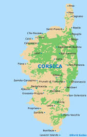 location for Atlantis until the end of the 18th century, when, according to Joscelyn Godwin [0746.36],Antoine Court de Géblin proposed Corsica and Sardinia as the location of Atlantis.
However, Atlantisforschung claims that as far as is known, Corsica was first associated with Atlantis, later, in 1840. At that time, it was the lawyer Angelo Mazzoldi, an ardent Italian nationalist, who claimed in a treatise that Italy had once been Atlantis, the center of which was somewhere near Corsica. He dated the sinking of Atlantis to 1986 BC(e).
Corsica did not feature again for over a century until 1929, when this idea was proposed at a meeting of the Society for Atlantis Studies, held in the Sorbonne in Paris, a delegate threw two tear gas bombs in order to prevent the dissemination of such ‘heresy’.
It may be worth considering that the Weshesh, listed as one of the Sea Peoples, have been identified with the inhabitants of Corsica among others. In the latter part of the 2nd millennium BC, a civilisation known as the Torreans occupied the region around Ajaccio. Like the Nuraghic people in nearby Sardinia, they also built towers, but smaller in size.
Before the Torreans, there was a string of megalithic dolmens stretching from southern Corsica across to northern Sardinia as if outlining a pilgrimage route. Frederico Bardanzellu’s website(a) offers more information on this and other aspects of the prehistory of these two islands, including a study of any possible astronomical significance that might be deduced from the orientation of the dolmens on both islands.(d)
Luigi Usai is currently (2021) promoting [1814] the idea that a conjoined Sardinia and Corsica had constituted the island of Atlantis!(c) He has named Sulcis at the southern end of Sardinia as the location of its capital.
In July 2021, I was sent a number of images that purported to show anomalous underwater images in the Central Mediterranean northeast of Malta. At first sight, they appeared to show extensive manmade features. However, further investigation by the person who sent them to me eventually discovered that the images were the consequence of the flawed computer interpretation of sonar data. In December 2021, Luigi Usai produced the same flawed imagery as evidence that he had discovered a lost submerged civilisation!
So that there is no misunderstanding, let me state that I have advocated a Central Mediterranean location for Atlantis for some years. If Sardinia and/or Corsica hold that location, I am more than happy to congratulate Usai and Frau. But I am not convinced by satellite imagery that has so often been proven to be flawed.
The Torreans have only been recognised since 1954, thanks to the work of archaeologist Roger Grosjean (1920-1975). A 1966 article by Grosjean is available online(b). The title of his paper, The Mysterious Horned Warrior – Torreans of the Isle of Corsica, brings to mind the horn-helmeted Sea Peoples depicted at Medinet Habu, a similarity not lost on Grosjean.
‘The Sea Peoples’ have been suggested by a number of Atlantologists as a collective name for the Atlantis federation.
(a) http://www.museodeidolmen.it/englishdefault.html
(c) https://www.atlantisfound.it/2021/01/24/why-didnt-scientists-find-atlantis-before-usai-luigi/
(d) https://www.museodeidolmen.it/englisharcheoastr.html
(e) Corsica (island) – Atlantisforschung.de (atlantisforschung-de.translate.goog)
Satellite Imagery
Satellite Imagery has recently been introduced into the Atlantis search with a variety of location claims based on features visible from space. These assertions include Albania (2007), Andalusia, Spain (2003), Cyrenaica, Libya (2005) and Sherbro Island, Sierra Leone (2007). All such claims must necessarily be treated with extreme caution unless substantiated by archaeology on the ground (or underwater). At best, only one of the sites listed here can be correct and probably all are not, since Atlantis is supposed to have been submerged and so not yet readily visible to the scrutiny of our current aerial mapping technology.
A number of satellite images showing underwater anomalies have been claimed as evidence of Atlantis, but so far all have been shown to be the result of faulty data gathering and/or defective analysis of the data.
In 2010, there was a claim that Atlantis had been located using satellite imagery that placed it underwater between Bermuda and the Bahamas.
One of the most extreme claims based on images has come from Joseph P.Skipper, who has identified some seafloor markings as an ancient script, apparently ignoring the fact that the lines of the writing would probably have to be a mile in width!
Skipper also promoted the rectangular Google Earth images of the Atlantic, west of Gibraltar, as the enormous ruins of manmade structures(c). Others claimed that the lines were ‘streets’. When Google explained that the images were a consequence of flawed data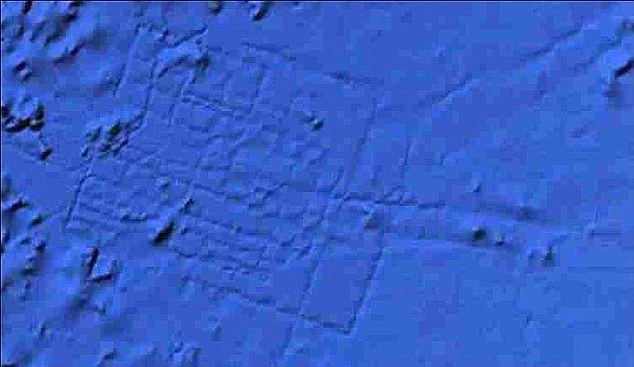 processing cries of ‘cover up’ could be heard. In the end, people believe what they want to believe.
In April 3, 2018, British tabloids regurgitated the same flawed images under the familiar ‘Atlantis FOUND’ headline, this time crediting Blake Cousins as the ‘discoverer’(d).
In July 2021, I was sent a number of images that purported to show anomalous underwater images in the Central Mediterranean northeast of Malta. At first sight, they appeared to show extensive manmade features. However, further investigation eventually revealed that the images were the consequence of the flawed computer interpretation of sonar data. In December 2021, Luigi Usai produced (a)(b) the same flawed imagery as evidence that he had discovered a lost submerged civilisation!
(a) Why didn’t scientists find Atlantis before Usai Luigi? ? Atlantis found!
(c) Ancient Atlantis or Another? (bibliotecapleyades.net)
Adlantis
Adlantis was imagined by Ignatius Donnelly to be another form of Atlantis. He notes that the first inhabitants of Arabia were known as Adites (Pt. IV Chap1). They were apparently named after Ad, who was fourth in line from Noah. Without any convincing reason, Donnelly states[121] that “these Adites were probably the people of Atlantis or Adlantis”. He also quotes an Arabic tradition that they are descended from Ad, son of Ham, although this is not confirmed by the Qur’an. However, the Qur’an does claim that Noah was allowed by God to warn the people of Ad of the impending Deluge.
A short discussion paper in Atlantisforschung mentions that the Ad people are referred to 14 times in the Qur’an and attributes the first identification of the Ad people as Atlanteans to Uwe Topper in 1977, nearly a century after Donnelly(a)!
The lost city of Ubar, also known as ‘Iram of the Pillars’, was discovered using satellite imagery in 1992 in southern Oman. The city had been sought after by Lawrence of Arabia and referred to by him as the ‘Atlantis of the Sands’, a name that has stuck. Its discovery prompted speculation that this was the city of the people of Ad mentioned in the Qur’an. An article by Harun Yahya discusses this idea from an Islamic viewpoint(b).
The location of Ubar has centred on the ancient Bedouin site of Shisr in the Dhofar province of Oman, but, as usual, there is controversy about this identification(c).
(b) The People of ‘Ad and Ubar, the Atlantis of the Sands (archive.org)
(c) https://en.wikipedia.org/wiki/Atlantis_of_the_Sands#Shisr
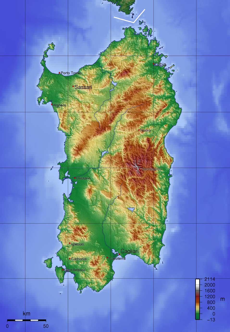
Sardinia
Sardinia is an autonomous region of Italy and after Sicily is the second largest island in the Mediterranean. Before the end of the last Ice Age, Sardinia had been joined to the European mainland because of the lower sea levels, which provided an easy access route for early settlers. Recent genetic studies revealed that “an exceptionally high proportion of the population is seemingly descended from people who have occupied it since the Neolithic and Bronze Age, between 8,000 and 2,000 years ago.”(al) Known to the Greeks as ‘Hyknusa’, during its long history, Phoenicians, Etruscans, Greeks and Romans have all left their mark on Sardinia. Before that, the megalith builders(j) were active in Sardinia and Corsica. A comprehensive history of Sardinia from the time of Atlantis is available online, in Italian and English(m). There is a tradition that Sardinia got its name from Sardus, son of Hercules(aa).
Sardinia’s important position in the ancient world was suggested by Mark McMenamin, a geologist at Mount Holyoke College in Massachusetts, who announced in Numismatist Magazine in November 1996(ar), that he believed that the Carthaginians produced gold coins, between 350 and 320 BC, depicting small maps of the Mediterranean world with India to the east and America to the west(e). When computer enhancement was applied to the images on some of those coins, he was amazed to note how the strange markings on them resembled maps made by Ptolemy, the Greek astronomer and geographer, who lived around 500 years later. The maps show what appears to emphasise the Mediterranean region, with Sardinia as a dot in the centre. The north coast of Africa appears at the bottom with Europe at the top, above the Phoenician homeland and India. The Strait of Gibraltar lies to the west; after that is the landmass of America. Some sceptics have been convinced of the correctness of McMenamin’s interpretation after seeing the enlarged images.
However, in 2000, McMenamin was obliged to confirm that the coins in question were fakes(as) as revealed in his book, Phoenicians, Fakes and Barry Fell [1738].
It has been suggested(p) that the ancient city (2000-1400 BC) of Nora, just south of today’s Pula, was thriving long before the arrival of the Phoenicians in the 8th cent. BC. It appears that contact between Sardinia and its trading partners suddenly ceased around 1400 BC, until the arrival of the Phoenicians. Phoenician inscriptions, one dated to the 11th century BC, were been found at Nora(q) in 1773. These inscriptions refer to Pygmalian, King of Tyre and to a battle between Sardinians and Phoenicians at Tarshish!
It has been postulated that the Shardana, one of the Sea Peoples of the 2nd millennium BC, gave their name to Sardinia and were probably the builders of the hundreds of Nuraghi there. Leonardo Melis, a native Sardinian, has studied and written at length on the subject. David Rohl, the archaeologist and advocate of revising generally accepted ancient chronologies, has argued[0232] that the Shardana were in fact originally from Sardis in ancient Anatolia and that they migrated westward to Sardinia following the collapse of the Hittite Empire.
Angelo Paratico also proposed a connection between the Lydian capital Sardis and Sardinia in a lecture delivered in Hong Kong in 2004(an). Wikipedia includes the following information “According to Timaeus, one of Plato’s dialogues, Sardinia and its people as well, the “Sardonioi” or “Sardianoi”, might have been named after “Sardò”, a legendary woman from Sardis, capital of the ancient Kingdom of Lydia in Anatolia.”(ao)
Apart from the enigmatic remains of the Nuraghic period, Sardinia has presented archaeologists with a greater mystery in the form of a structure at Monte d’Accoddi that closely resembles a Mesopotamian ziggurat. The earliest parts of the monument have been dated to circa 3000 BC – the same period during which comparable step pyramids were being built in Mesopotamia. Leonardo Melis has speculated that the name of the site, Accoddi, may be connected to the Akkadian civilisation. Step pyramids are also found in Sicily(c) and additionally the Le Barnenez cairn(ad) (4500-4700 BC), in Brittany, has a superficial resemblance to some of the Western Mediterranean ‘pyramids’.
Philip Coppens, author of The New Pyramid Age [759] has also written a paper(az) on Sardinia’s only known pyramid Monte d’Accoddi concluded that “despite almost forty years of excavation on the site, we know little as to what Monte d’Accoddi was, beyond the “visually obvious”. We do not know its use, nor why it was built, or why it was unique. However, the fact that there are so many questions, illustrates how little we truly know about “the pyramid movement” and how it inspired people all over the world, whether in Egypt, Peru, Mesopotamia or here in Sardinia, to begin the construction of pyramids. Currently, the oldest pyramids have been found in Peru. And though in the “Old World” we link pyramids specifically with Egypt, one group of people in north-western Sardinia had built one long before the Egyptian Pyramid Age ever began. That’s all we know, and that’s not much, is it?”
 Recent discoveries of statue menhirs on Sardinia have suggested that in the 4th millennium BC the island was part of a culture which spread from the Black Sea to the Atlantic(f).
The ancient-wisdom.com website, in a well-illustrated article, has drawn attention to the fact that the nuraghi, while very numerous, are not the only distinct form of megalithic monuments on the island, but there are two others known as ‘Tombes Gigantes’ (Giants Tombs) and ‘Domus de Janas’ (Spirit Homes).(ap)
Statue menhirs are also found on adjacent Corsica.
Apart from the Monte d’Accoddi feature, the statue menhirs and the thousands of nuraghi, Sardinia has another mystery to offer, in the form of cart ruts comparable with the better-known ruts on Malta. Dr Dominique Görlitz has also studied the cartruts found in Sardinia(ax). Images of these ruts can also be seen in a YouTube video(ay).
The end of the 18th and the beginning of the 19th centuries saw Antoine Court de Géblin and Delisle de Sales suggesting Sardinia as a remnant of Atlantis. However, the first person in more recent times to promote a Sardinian Atlantis was Paolo Valente Poddighe, who did so in 1982, but it was 2006 before he published a book[711] supporting this claim.
It was nearly another twenty years before Robert Paul Ishoy was the first to have a website(a) that promoted Sardinia as the site of Atlantis. His contention is that Atlantis was a powerful state based in Sardinia which controlled most of the western Mediterranean and was at its peak between 2000 BC and 1400 BC. Ishoy further contends that the Keftiu, Atlantean and Nuraghi cultures were all one. He contends that they made attempts to conquer the principal civilisations of the eastern Mediterranean, including the Minoans, Athenians and Egyptians. During one of these attacks, the Athenians, with the unexpected support of floods and earthquakes, defeated the Atlanteans. Ishoy has been planning an expedition to Sardinia to seek further evidence in support of his thesis.
In 2002, the Italian journalist, Sergio Frau, published a book[302], in Italian, which firmly located Atlantis just south of Sardinia, where it is now covered by water(ah). He argued that the Pillars of Heracles were at one time located as a boundary marker at the Strait of Sicily and later moved to Gibraltar as the Greek awareness of the western Mediterranean developed through expanded trade. Frau attributes this change of location to the geographer Eratosthenes, who flourished more than a century after Plato. Understandably, his theory has been greeted with the usual hail of criticism, but was given support by UNESCO when it organised a symposium on the theory in Paris in 2005, followed by an exhibition in Rome the following year.
In the interest of balance, Thorwald C. Franke’s critique(n) of Frau’s work is required reading, as well as a 21-point refutation of Frau’s book signed by 71 Sardinian historians, geologists and archaeologists(w). However, others such as Silvio Diego Novo have followed Frau’s lead(aq), while Aldo Bonincontro has also nominated Sardinia as Atlantis, which he did in a 2007 article, but without any reference to Frau!
It is obvious that there is considerable local support for the idea of a Sardinian Atlantis, but for some, this seems to be often linked with the independence movement on the island.
In June 2015 Frau, together with a number of Italian scientists, joined him when he visited Sardinia(x). They included historian Mario Lombardo; archaeologist Maria Teresa Giannotta; Claudio Giardino, a specialist in ancient metallurgy; cartographer Andrea Cantile; archivist Massimo Faraglia; and Stefano Tinti, a geophysicist and expert on tidal waves. Their objective was to study the evidence of a huge tsunami inundating the southern part of the island in ancient times.
A report in The Guardian (15/8/15) noted(y) that “Professor Tinti explained that until the 1980s no one was aware that tidal waves had occurred in the Mediterranean. But since 2004, scientists have identified 350 events of this type over a 2,500-year period,” and regarding the Sardinian tsunami, “So what would have been required in our case?” he then asked. “We’re talking about a huge volume of water, some 500 metres high [the elevation up to which the nuraghi were affected]. Only a comet could do that if the impact occurred very close to the coast and in a very specific direction,” he asserted. An event of this sort may have occurred near Cagliari, with the resulting wave devastating the plain of Campidano.”
Afterwards, Frau’s claim was given further attention(u) when an exhibition in the museum in Sardara, focused on that catastrophe and hit the island around 1175 BC. This cataclysm mainly affected the southern portion of Sardinia, covering it with a layer of mud. A geophysicist, Stefano Tinti, claims that the most likely cause of such an incursion would be an enormous tidal wave resulting from the impact of a comet in the Mediterranean. It was not surprising that Jason Colavito debunked(v) any linkage of Sardinia with Atlantis as well as the claim of a cometary impact, but avoided offering any explanation for the layer of mud.
A French website offers an interesting titbit regarding the extent of the mud, noting that “A nuraghe was discovered not far from the Sardinian town of Barumini.Les archéologues ont mis 14 ans pour ôter les 12 mètres de boue qui recouvraient ce monument. The archaeologists took 14 years to remove the 12 meters of mud that covered this monument”.
An alternative view of Sardinia and its nuraghi was offered(z) by Brian Cairns on the Thunderbolts website, where he claimed that the nuraghi were constructed to offer protection from cosmic electrical strikes. In his conclusion, he states that “while the evidence above is circumstantial, it seems that Sardinia had a very active electric environment.”
The late Vittorio Castellani, who had advocated locating Atlantis in the British Isles, was so impressed by Frau’s book that he changed his mind and supported the idea of a Sardinian Atlantis. Another keen supporter of Frau is Mario Tozzi, who has also suggested that if Sardinia was Atlantis, the mysterious Etruscans may have been Sardinians(r)(s). Further support has come from Mario Cabriolu and architect Paolo Macoratti, who identifies the Plain of Campidano with the Plain of Atlantis and locates the Atlantean capital further south in the Gulf of Cagliari, illustrated on a map on the sardolog.com site(t).
As Sardinia is still very much above water, it might seem an unlikely choice as the location of Atlantis. However, if it is accepted that the Pillars of Heracles were in fact situated in the Strait of Sicily, there are a number of features on Sardinia that would support the theories of Ishoy and Frau. There is evidence that the large plain of Campidano was inundated, from the south, by a tsunami, following an earthquake, in the Central Mediterranean in the 2ndmillennium BC. Professor Mauro Perra has argued against this(o) using extensive stratigraphic evidence. However, this tsunami also covered Punic and Roman remains indicating a much later date.
Furthermore, there are mountains protecting the plain from cold northern winds and rich mineral deposits are also found in the locality. Sardinia was well-known in ancient times as a source of silver as well as copper, iron and lead(af). There is also some evidence that a small but important quantity of tin was available on the island according to Stephen L. Dyson and Robert J. Rowland Jnr., in their recent history of Sardinia[1530]. The excellent phoenicia.org website comments that Sardinia can scarcely have been occupied by the Phoenicians for anything but its metals. The southern and south-western parts of the island, where they made their settlements, were rich in copper and lead; and the position of the cities seems to indicate the intention to appropriate these metals.
In 2010, Giuseppe Mura published a book of nearly 600 pages, in which he identifies the Gulf of Cagliari as the location of the Pillars of Heracles that previously led to a channel which gave access to the Plain of Campidano, which he claims(g)(h) was the Plain of Atlantis described by Plato.
 Furthermore, another young Sardinian has recently pointed out that colours associated by Plato with Atlantis, namely red, white and black, are found naturally on the island as well as excavated buildings of the Nuraghic period being painted in red and black stripes. The Sardinian regional flag also uses these colours.
We can expect that the future will see further development of the Sardinian Theory, which shows more promise than many of the other suggested locations.
For those interested in reading more about the history of Sardinia from its prehistory until the present should visit Claudio de Tisi’s website(i) (In Italian and English). It includes a review of Sergio Frau’s book on Atlantis. In 2011, travel writer Angela Corrias wrote a two-part article)(ab)(ac), which also includes a review of Frau’s theory.
There would appear to be growing support from local researchers on the island for a Sardinian Atlantis. One of the more recent is Giorgio Valdés, who equates Sardinia with Tartessos and Atlantis. This idea of Sardinia and Tartessos being identical goes back to the middle of the 20th century, when Wikipedia(k) tells us “that W.F. Albright (1941) and F.M. Cross (1972) suggested Tarshish was Sardinia because of the discovery of the ‘Nora Stone’ or ‘Nora Fragment’.” An extensive article(l) on the Nora Stele, in Italian, was written in January 2014, based on a translation by Jose Stromboni.
In 2013, Marin, Minella & Schievenin stated [972.43] that Sardinia was called Tartessos in ancient times, unfortunately, without providing any references.
In August 2016, Frau’s theory received a further spurt of publicity with an interview in Sputnik News, which was followed a few days later by the announcement that National Geographic was planning a documentary, co-produced by James Cameron and Simcha Jacobovici, based on Robert Ishoy’s Atlantis in Sardinia theory(ae).
However, Diaz-Montexano is also certain that the documentary will focus on his theory(ai). In the end, both theories were featured in what turned out to be a disappointing documentary.
In late 2016, Nicola Betti, Luciano Melis & Alessandro Mugria published Il mare addosso. L’isola che fu Atlantide e poi divenne Sardegna [1571] in which they add their support to the idea of Atlantis in Sardinia. They believe “with reasonable certainty that a large area of south-west Sardinia was hit by a swarm of iron meteorites in a period between 11,000 and 9000 BC,” which would have caused a catastrophic mega-tsunami(am).
Pier Paolo Saba, another Sardinian, suggests in his book Atlantide [739], that following a catastrophe around 10,000 BC, Atlantis was destroyed and survivors were dispersed to the Americas, Northern Europe and the Mediterranean. One group settled in Saba’s native Sardinia, where they became the Shardana and were responsible for the building of the thousands of nuraghi found throughout the island and were part of the Sea Peoples who attacked Egypt(au)(av).
In 2020, Marc Deneux published an ebook, Voyage en Atlantide (Voyage to Atlantis) in which he offers a ‘new hypothesis’ that places Atlantis off the coast of Sardinia. As you can see from the data above, the idea is far from new, as it can be traced back to the 18th century!
Luigi Usai is now promoting [1814] the idea that a conjoined Sardinia and Corsica had constituted the island of Atlantis and its capital was located at Sulcis at the southern end of Sardinia!(at) In 2024, Usai published a revised version of his thesis(ba). An important Phoenician city called Sulci was situated on the island of Sant’antioco, while the smaller island of San Pietro, just a short distance to the north, has two seastacks of the town of Carloforte, identified as the Pillars of Heracles by Professor Giorgio Saba. Usai has endorsed this identification.
In July 2021, I was sent a number of images that purported to show anomalous underwater images in the Central Mediterranean northeast of Malta. At first sight, they appeared to show extensive manmade features. However, further investigation by the person who sent them to me eventually discovered that the images were the consequence of the flawed computer interpretation of sonar data. In December 2021 Luigi Usai produced the same flawed imagery as evidence that he had discovered a lost submerged civilisation!
So that there is no misunderstanding, let me state that I have advocated a Central Mediterranean location for Atlantis for some years. If Sardinia holds that location, I am more than happy to congratulate Usai and Frau. But, I am not convinced by satellite imagery that has so often proven to be flawed.
I must include here a mention of the website of Pierluigi Montalbano, where he and various guest authors have written many interesting articles about Sardinia and its Nuraghic past, as well as Atlantis. The site is well worth a browse and as it has Google Translate built-in, making it easily accessible to all(aw).
(b) http://web.archive.org/web/20200215021700/https://atlantipedia.ie/samples/archive-2139/
(c) http://web.archive.org/web/20200215021735/https://atlantipedia.ie/samples/archive-2650/
(e) https://www.migration-diffusion.info/article.php?authorid=22
(f) Stone Pages Archaeo News: Huge number of statue menhirs found on a Sardinian wall (archive.org)
(g) https://gianfrancopintore.blogspot.com/2011/03/atlantide-in-sardegna-e-cagliari-i.html
(h) https://gianfrancopintore.blogspot.com/2011/03/atlantide-in-sardegna-e-cagliari-ii.html
(i) See: https://web.archive.org/web/20180204153209/https://www.lamiasardegna.it/files/storia-index.htm
(j) http://www.museodeidolmen.it/englishdefault.html
(k) https://en.wikipedia.org/wiki/Tarshish
(m) See: https://web.archive.org/web/20180204153209/https://www.lamiasardegna.it/files/storia-index.htm
(n) https://www.atlantis-scout.de/atlantis-sergio-frau-english.htm
(o) https://pierluigimontalbano.blogspot.ie/2014/04/uno-tsunami-cancello-la-civilta-nuragica.html (Italian)
(p) In Search Of Atlantis: Clues In Cagliari, Sardinia (archive.org)
(q) https://en.wikipedia.org/wiki/Nora_Stone
(r) Atlantide, Sardegna? » TOZZI DI SCIENZA – Blog – NATIONAL GEOGRAPHIC ITALIA (archive.org) (Italian)
(t) SardoLog – Sardegna è Atlantide? (archive.org)
(u) https://www.theguardian.com/science/2015/aug/15/bronze-age-sardinia-archaeology-atlantis
(v) https://www.jasoncolavito.com/blog/did-a-comet-destroy-atlantis-in-bronze-age-Sardinia
(w) “La Sardegna (che non esiste) di Sergio Frau”, l’invito di Alessandro (…) – Atlantikà (archive.org) (Italian)
(x) https://anthropologistintheattic.blogspot.ie/2015/11/was-sardinia-home-to-mythical.html
(y) https://www.theguardian.com/science/2015/aug/15/bronze-age-sardinia-archaeology-atlantis
(z) https://www.thunderbolts.info/wp/2015/11/20/neolithic-man-and-the-electric-universe/
(aa) https://en.wikipedia.org/wiki/Sardus
(ab) http://web.archive.org/web/20191216195251/https://atlantipedia.ie/samples/archive-2898/
(af) https://en.wikipedia.org/wiki/History_of_mining_in_Sardinia
(ag) https://phoenicia.org/minning.html
(ah) https://en.yibada.com/articles/155860/20160831/atlantis-really-sardinia-claims-expert.htm
(ai) https://translate.google.co.uk/translate?hl=en&sl=es&u=https://atlantisng.com/blog/&prev=search
(aj) La Sardaigne, l’Atlantide enfin retrouvée? – 24.08.2016, Sputnik Afrique (archive.org)
(ak) https://www.academia.edu/4635111/Were_the_Sea_Peoples_Mycenaeans_The_Evidence_of_Ship_Iconography
(al) Archaeogenetic findings unlock ancestral orig | EurekAlert! (archive.org)
(an) https://www.gingkoedizioni.it/is-there-an-association-between-sardis-and-sardinia/
(ao) https://en.wikipedia.org/wiki/Sardinian_people
(ap) http://www.ancient-wisdom.com/italysardinia.htm
(aq) http://web.archive.org/web/20191216233204/https://atlantipedia.ie/samples/archive-2353/(Italian)
(ar) https://www.researchgate.net/publication/236000049_Cartography_on_Carthaginian_Gold_Staters
(at) https://www.atlantisfound.it/2021/01/24/why-didnt-scientists-find-atlantis-before-usai-luigi/
(au) The second possible Atlantis in Wisconsin ?, page 1 (archive.org)
(av) http://www.commuicati-stampa.ws/2009/02/10/1413
(aw) https://pierluigimontalbano.blogspot.com/2014/04/uno-tsunami-cancello-la-civilta-nuragica.html
(ax) On the trail of the Cart Rut mystery – Atlantisforschung.de (atlantisforschung-de.translate.goog)
(az) https://www.eyeofthepsychic.com/nap_art13/