Claudius Ptolemy
Eridanus
Eridanus is the name of a constellation in the Southern Hemisphere as well as the name of the only Atlantean river named by Plato (Crit. 112a). It has been identified with a number of waterways(b) including the Nile (Eratosthenes), the Eider (Spedicato)(d), the Rhine(f), the Istros (Danube) of Hungary(g) and the Po (H. S. Bellamy). Mythology has fiery Phaëton crashing into the Eridanus, which means ‘early burnt’.
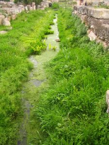
 Adding to the confusion is the existence of the River Eridanos, referred to by Plato (Phaedrus 229) which is a tributary of the Ilissos and is still partly visible in the centre of modern Athens(e). (see left image)
Jürgen Spanuth was convinced that it was as either the Elder or the Eider, which flow into the North Sea opposite Helgoland. Emilio Spedicato echoed Spanuth’s views in a number of more recent articles(c)(d) and opted for the Eider as the original Eridanus. The similarity of the two names also adds some credence to this idea.
The late Walter Baucum quoted[183.159] the Swiss historian and geographer, Frederic de Rougemont (1808-1876), who, in his 1866 book, L’Age de Bronze, ‘proved’ that originally the Rhine had been known as the Eridanus.
Apollonius of Rhodes in his Argonautica refers to the River Eridanus as flowing into the Cronian Sea(a), generally accepted as the North Atlantic. The Eridanus is frequently referred to in ancient Greek texts as an amber-rich river in Northern Europe. Amber was claimed by Spanuth to have been the Orichalcum of Plato’s Atlantis.
Kai Helge Wirth[627], a German geographer, has advanced the controversial theory that the configuration of the constellations was chosen to conform with the outlines of various Mediterranean and Atlantic coasts and was used as navigational aids to ancient mariners. As part of this radical idea, Wirth has pointed out that the constellation Eridanus closely follows the meandering Eider rather than the Po.
Geologists have given the name Eridanus to a river which flowed where the Baltic is now located. Claudius Ptolemy identified the River Duna, which flows into the Gulf of Riga in the Baltic, as the Eridanus.
(a) http://www.theoi.com/Text/ApolloniusRhodius4.html
(b) Star Tales – Eridanus (ianridpath.com)
(c) https://www.2008-paris-conference.org/mapage13/phaethon-to-chapamacac.pdf
(d) Wayback Machine (archive.org) *
(e) https://en.wikipedia.org/wiki/Eridanos_(Athens)
(f) https://www.bibletools.org/index.cfm/fuseaction/Topical.show/RTD/CGG/ID/2236/Danube.htm
(g) https://www.theoi.com/Potamos/PotamosEridanos.html
Fortunate Isles (L)
Fortunate Isles or Isles of the Blest is a term that has been applied to many islands over the ages but has been consistently described as being ‘in the west’. It is most commonly believed that the term was originally used to describe the Canary Islands, which in turn are considered by many to be remnants of Atlantis.
Marinus of Tyre, writing around 120 AD wrote of the Fortunate Isles as the western boundary of the known world and he was followed by Claudius Ptolemy (90-168 AD) who used the Fortunate Islands as the prime meridian for his Geographia(a) . However, although there is a general acceptance that the Canaries should be considered the Fortunate Isles, Ptolemy’s prime meridian runs more closely to the Cape Verde Islands!
Peter de Roo identifies Madeira and the Canaries as the Fortunate Islands in a map in his 1900 book History of America before Columbus[0890]..
Macaronesia which is derived from the Greek meaning ‘islands of the fortunate’ is a modern geographical term used to collectively describe the islands of Madeira, Azores, Canaries, Cape Verde and the Savage Islands. The term ‘Fortunate Isles’ is also applied to the Scilly Isles off the coast of Cornwall.
See: Hesperides, Eugene Pégot-Ogier
