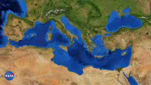
Mediterranean Sea
The Mediterranean Sea is at the heart of the Atlantis story. Solon brings the tale back from Egypt to Athens and relates how the Atlanteans controlled the Mediterranean as far as Tyrrhenia and Egypt. The Atlanteans then attacked Athens and Egypt. The exact extent of Egyptian-controlled territory at the time of Atlantis is unclear. One site(c) suggests that it stretched nearly as far as Syrtis Major, which has been proposed by some as the location of Atlantis.
The Atlanteans attack Athens and Egypt. Although the Pillars of Heracles are now generally believed to have been located at the Strait of Gibraltar, a number of other locations in the Mediterranean are known to have been similarly designated at different periods. As I have argued elsewhere, the Pillars of Heracles were undoubtedly a designation for the Strait of Gibraltar from the time of Eratosthenes, there is clear evidence that it was applied to other locations in earlier ages and probably over time, it became a metaphor for the limits of Greek maritime knowledge.
I may be the first to claim here that modern studies of Homer’s Odysseus offer a possible argument in favour of a Central Mediterranean Atlantis. Armin Wolf, the German historian, has made a 40-year study of 80 theories regarding the route taken by Odysseus. Around 30 of these included maps, a number of which are included in Wolf’s book, Homers Reise: Auf den Spuren des Odysseus[669], a shorter version in English, including maps, is also available as a pdf file(a). It is obvious that although a reasonable degree of agreement exists between many of the theories regarding the position of the twelve specific locations recorded by Homer, those that confine the ‘wanderings’ to the Mediterranean, consistently keep all locations in the eastern basin and Central Mediterranean with the sole exception of the inclusion of Gibraltar which looks out of place on maps, with apparently nothing happening on the way there or on the return trip. Wolf’s carefully thought out route does not include Gibraltar and in my opinion, is a better reflection of actual Greek seafaring knowledge and naval capabilities at that time and adds a further suggestion, however inconclusive, that the Pillars of Heracles were situated in the Central Mediterranean. Wolfgang Geisthövel follows Wolf’s conclusions in Homer’s Mediterranean[1578].
Today’s leading theories regarding the location of Atlantis are virtually all related to the Mediterranean region. Between Morocco in the west and the Black Sea in the east, there is an embarrassment of suggested locations.
The principal objection to a Mediterranean location for Atlantis is frequently claimed to be the apparent physical extent of the island as described by Plato, which if accepted as written, could not have fitted anywhere in that body of water. He gives us measurements for the plain adjacent to the city as being 240×360 miles. However, it is widely agreed that most of Plato’s dimensions are highly suspect and exaggerated by as much as a factor of ten.
On the other hand, if Atlantis had been located outside the Mediterranean it is difficult to understand how the disaster that destroyed Atlantis could also have obliterated the Athenian army when the two locations would have been over 1700 miles apart. No single known natural disaster, such as an earthquake, could have affected the two cities at the same time as the text seems to imply. So if they were destroyed concurrently we must conclude that the two locations were situated in the same region and since Athens was clearly in the Mediterranean so must Atlantis. However, Plato does not explicitly say that the two armies were destroyed at the same time, although it seems to be implied.
As stated in the Invasion entry, all ancient empires expanded through the invasion of adjacent territories and so there is no good reason to think that Atlantis’ attack was not launched against an Athens that was within easy striking distance. This proximity could explain the inference that Atlantean and Athenian armies were destroyed simultaneously by some natural catastrophe!
Finally, please consider the following facts;
(1) Herodotus tells us that the ancient Greeks only knew of three continents, Asia, Europe and Libya (Africa) (Hist.4.42).
(2) Plato never called Atlantis a continent but consistently referred to it as an island.
(3) Finally, Herodotus also describes Sardinia as “the biggest island in the world.” (Hist.6.2)**, confirming a lack of knowledge of the world beyond the Mediterranean.
When all these details are taken together they offer a compelling argument in favour of a Mediterranean Atlantis.
** Sicily is larger in terms of area (25,708 v 24,090 km2). However, the coastal length of Sardinia is much greater than Sicily’s (1843 v 1115 km). Felice Vinci recently explained[019] how ancient seafarers measured territory by its coastal perimeter rather than by its area, as we do today. So Herodotus was correct according to the conventions of his day.
Cyprian Broodbank is a co-author with Giulio Lucarini of a paper(b) about Mediterranean Africa that “draws on a new surge in data to present the first up-to-date interpretative synthesis of this region’s archaeology from the start of the Holocene until the threshold of the Iron Age (9600–1000 bc).”
(a) Wayback Machine (archive.org)
(c) https://starshinetours.com/first-signs-of-weakening/ (link broken) *

