Latest News

Joining The Dots
I have now published my new book, Joining The Dots, which offers a fresh look at the Atlantis mystery. I have addressed the critical questions of when, where and who, using Plato’s own words, tempered with some critical thinking and a modicum of common sense.Read More »
continent
Courville, Matthew P.
Matthew P. Courville is the Canadian author of Ancient Navigators [1960] with the bold subtitle of Phoenician Colony of Atlantis. The author is not the first to associate the Phoenicians with Atlantis, but he is certainly the first to offer a reasoned argument, rather than speculation, to justify the suggestion. That is not to say that Courville has completely avoided conjecture.
He suggests that the ‘opposite continent’ referred to by Plato was Africa. Many have proposed America, while I offered Europe, specifically Southern Italy. One important point with which I agree with Courville on, is that the apparent date of 9600 BC, offered by Plato for the time of the Atlantean War is blatantly wrong.
However, we disagree on a number of other issues. Courville arbitrarily decided that the unit of linear measure, the Greek stade, employed by Plato, should have been the ‘plethrum’, but offers little to support this contention. Also unexplained is when Plato does use the plethron are we also to assume that he meant something else? In Critias 116a & 118c the stade and the plethrum appear together but in contexts where, taken at face value, both appear to offer exaggerated dimensions!
I found Courville’s reinterpretation of Athanasius Kircher’s map of Atlantis particularly annoying. Kircher clearly marked Atlantis as situated in the Atlantic Ocean, with Spain and Africa on one side and America on the other. If, as proposed by Courville, Atlantis is Africa, how could it be between itself and America as shown on Kircher’s map? However, my view is that Atlantis was situated in the Mediterranean, where the only two locations unambiguously named as Atlantean were located, namely Southern Italy and North Africa, along with some of the numerous Central Mediterranean islands.
I could continue on a nitpicking expedition, but it would seem pointless if we cannot agree on the basic question of the location of Atlantis. His idea that the Atlanteans were Phoenician must compete with the theories that they were connected with the Sea Peoples or the Hyksos, both of whom were active in the second millennium BC.
The author has obviously put a lot of work into this book, so it is a pity that we have a 400-page work without an index.
Fundamentalist Atlantology
Fundamentalist Atlantology is a term that I use to describe the idea that everything written about Atlantis by Plato, must be taken at face value. In other words, when he refers to 9,000 years, this along with all the other numbers he uses in relation to the dimensions of the plain of Atlantis, its structures or its military manpower should be accepted literally! Such an acceptance flies in the face of both common sense and science, particularly in the case of Plato’s dating of Atlantis, while the dimensions he has for the ditch surrounding the plain of Atlantis were deemed incredible (his word) by Plato himself (Crit.118c), he felt obliged out of deference to Solon’s reputation, to record the details as he received them from him.
Without wishing to offend anyone, I believe that acceptance, for example, of Plato’s/Solon’s numbers is comparable with the belief of religious fundamentalists who hold that creation ’took just six days’.
Although, understandably, researchers have accepted Plato’s details without question, there has been extensive research over the past century into seeking more rational explanations for many of those more difficult passages in the Atlantis narrative, which has produced alternative explanations compatible with both science and common sense.
While Plato’s 9,000 years were initially, rather glibly dismissed as a transcription error and that hundreds and not thousands had been intended, it has been demonstrated that the ancient Egyptian priesthood used a lunar calendar so that the ‘ýears’ were in fact months, which was noted in the 4th century BC, by Eudoxus of Cnidos and repeated by Manetho and Diodorus Siculus. This would reduce the timeline by a factor of twelve. Another explanation was put forward by Rosario Vieni, who proposed that the ‘years’ actually referred to seasons, of which there are three in the Egyptian solar year. These, as far as I am aware, are the principal alternatives suggested in place of a literal reading of 9,000 years. After all, neither Athens or Egypt was home to anything more than primitive societies 9,000 years before Solon’s visit.
A further example concerns the size of Atlantis, which Plato consistently referred to as an island and never a continent and is described by him as greater than Libya and Asia combined. Irrespective of how extensive in size the Libya and Asia in question were, the Greek word for greater – meizon, actually relates to greater in strength, power or influence not extent. A few years ago, Thorwald C. Franke, pointed out that the traditional enemies of Egypt came from Libya and Asia, so that to describe the threat from Atlantis as greater than Libya and Asia combined, indicates how great the threat from Atlantis was.
The more contentious issue of the actual location of the Pillars of Heracles, I will not go into here, suffice it to say that a number of valid competing arguments have been put forward in favour of locations, other than the Strait of Gibraltar. In fact all of them could have been correct at different times, changing their position as the Greek colonists and traders gradually moved westward. Eventually, I believe that at some point in time, the term simply became a metaphor for the limits of the world as generally known to the Greeks.
My point is that understandable difficulties exist in the Atlantis texts and that a number of sensible alternative explanations have been put forward, which will be individually tried and tested until a consensus emerges, in the same way that the idea of a geocentric universe was gradually replaced by the simple fact that our little planet revolves around the sun.
Northcote, Jonathan *
Jonathan Northcote is a South African legal practitioner and the author of 16.484ºW 58.521ºN Atlantis, Found?[1369] in which he applies his professional forensic skills to the question of Atlantis. Although initially brought to the subject by Otto Muck’s book[0098], he found aspects of Muck’s ideas unacceptable and began an investigation of his own that led him to conclude that the region of Rockall in the North Atlantic is the most likely candidate as the location of Atlantis,
There is no doubting the quality of Northcote’s research, particularly relating to the geology and underwater topography of the Rockall region, which is fully referenced. However I cannot agree with his treatment of a number of critical items in Plato’s text. These relate to words and phrases such as, continent, Pillars of Heracles, Atlantic, greater than Libya and Asia combined and elephants.
In 2018, Stuart L. Harris, citing Northcote’s work, published four papers (a-d) on the academia.edu website endorsing the Rockall Plateau as the location of Atlantis. Harris adopts some of Emilio Spedicato’s theories and attributes the destruction of Atlantis to a catastrophic encounter with Nibiru in 9577 BC.
In January 2019, Northcote revised his book with additional material and published this second edition with the title of Atlantis, Found? An investigation into ancient accounts, bathymetry and climatology [1611]. I am currently working my way through this latest offering and hope to review it in the near future.
Italy
Italy seems to have an uncertain etymology; Thucydides claims that Italos, the Sicilian king gave his name to Italy, while more recently Emilio Spedicato(h) considers that ”the best derivation we believe to be the one proposed by the Italian nuclear engineer Felice Vinci (1998), in his monograph claiming a Baltic setting for the Homeric epic: he derives Italia from the rare Greek word aithalia, meaning the smoking one.” This is thought to be a reference to Italy’s many volcanoes.
Italy today is comprised of territory south of the Alps on mainland Europe including a very large boot-shaped peninsula, plus Sicily, Sardinia and some smaller island groups, which along with the French island of Corsica virtually enclose the Tyrrhenian Sea.
The earliest proposal that Italy could be linked with Atlantis came from Angelo Mazzoldi in 1840, when he claimed that before Etruria, Italy had been home to Atlantis and dated its demise to 1986 BC. Mazzoldi expressed a form of hyperdiffusion that had his Italian Atlantis as the mother culture which seeded the great civilisations of the eastern Mediterranean region(b).
Some of Mazzoldi’s views regarding ancient Italy were expanded on by later scholars such as Camillo Ravioli, Ciro Nispi-Landi, Evelino Leonardi, Costantine Cattoi, Guido DiNardo and Giuseppe Brex. Ravioli sought to associate the Maltese island of Gozo with his proposed Atlantis in Italy.
The Italian region of Lazio, which includes Rome, has had a number of very ancient structures proposed as Atlantean; Monte Circeo (Leonardi) and Arpino(a) (Cassaro). Another aspect of Italian prehistory is the story of Tirrenide, which was described as a westward extension of the Italian landmass into the Tyrrhenian Sea during the last Ice Age, with a land bridge to a conjoined Sardinia and Corsica. At the same time, there were land links to Sicily and Malta, which were all destroyed as deglaciation took place and sea levels rose.
 It is surprising that so few researchers have commented on Italy’s part in Plato’s Atlantis narrative considering that he twice, without any ambiguity, informs us that the Atlantean domain extended as far as Tyrrhenia (modern Tuscany).
Crit.114c. So all these, themselves and their descendants dwelt for many generations bearing rule over many other islands throughout the sea and holding sway besides, as was previously stated, over the Mediterranean peoples as far as Egypt and Tuscany. Tim.25a/b. Now in this island of Atlantis there existed a confederation of kings, of great and marvellous power, which held sway over all the island, and over many other islands also and parts of the continent; and, moreover, of the lands here within the Straits they ruled over Libya as far as Egypt, and over Europe as far as Tuscany. (Bury)
The quotation from Timaeus is most interesting because of its reference to a ‘continent’. Some have understandably but incorrectly claimed that this is a reference to America or Antarctica, when quite clearly it refers to southern Italy as part of the continent of Europe. Moreover, Herodotus is quite clear (4.42) that the ancient Greeks knew of only three continents, Europe, Asia and Libya.
Philo of Alexandria (20 BC-50 AD) in his On the Eternity of the World(g) wrote “Are you ignorant of the celebrated account which is given of that most sacred Sicilian strait, which in old times joined Sicily to the continent of Italy?” (v.139). The name ‘Italy’ was normally used until the third century BC to describe just the southern part of the peninsula(e). Some commentators think that Philo was quoting Theophrastus, Aristotle’s successor. This would push the custom of referring to Italy as a ‘continent’ back near to the time of Plato. More recently, Armin Wolf, the German historian, when writing about Scheria relates(f) that “Even today, when people from Sicily go to Calabria (southern Italy) they say they are going to the ‘continente’.” This continuing usage is further confirmed by a current travel site(d) and by author, Robert Fox[1168.141]. I suggest that Plato used the term in a similar fashion and can be seen as offering the most rational explanation for the use of the word ‘continent’ in Timaeus 25a.
When you consider that close to Italy are located the large islands of Sicily, Sardinia and Corsica, as well as smaller archipelagos such as the Egadi, Lipari and Maltese groups, the idea of Atlantis in the Central Mediterranean can be seen as highly compatible with Plato’s description.
If we accept Plato stated unambiguously that the domain of Atlantis included at least part of southern Italy and also declared Atlantis attacked from beyond the Pillars of Heracles, then this appellation could not be applied at that time to any location in the vicinity of the Strait of Gibraltar but must have been further east, probably not too far from Atlantean Italy. This matches earlier alternative locations recorded by classical writers who placed the ‘Pillars’ at the straits of Messina or Sicily. I personally favour Messina, unless there is stronger evidence that some of the islands in or near the Strait of Sicily, such as the Maltese or Pelagian Islands, or Pantelleria, were home to the ‘Pillars’.
(a) http://www.richardcassaro.com/hidden-italy-the-forbidden-cyclopean-ruins-of-giants-from-atlantis
(b) http://web.archive.org/web/20211202122517/https://atlantipedia.ie/samples/archive-2509/ (Eng),
http://web.archive.org/web/20211021081119/https://atlantipedia.ie/samples/archive-2943/ (Ital)
(c) http://web.archive.org/web/20200215123300/https://atlantipedia.ie/samples/archive-2946/
(d) Four Ways to Do Sicily – Articles – Departures (archive.org)
(e) https://profilbaru.com/article/Name_of_Italy
(f) Wayback Machine (archive.org)
(g) http://www.earlychristianwritings.com/yonge/book35.html
(h) http://2010-q-conference.com/ophir/ophir-27-10-09.pdf
Magna Graecia
Magna Graecia is the term applied to those parts of southern Italy and  Sicily colonised by the Greeks, beginning as early as the 8th century BC. An interesting fact is that Philo of Alexandria (20 BC-50 AD) in his On the Eternity of the World(b) wrote: “Are you ignorant of the celebrated account which is given of that most sacred Sicilian strait, which in old times joined Sicily to the continent of Italy?” (v.139). The name ‘Italy’ was normally used in ancient times to describe the southern part of the peninsula(d). Some commentators think that Philo was quoting Theophrastus, Aristotle’s successor. This would push the custom of referring to Italy as a ‘continent’ back to the time of Plato. More recently, Armin Wolf (1935- ), the German historian, when writing about Scheria relates(a) that “Even today, when people from Sicily go to Calabria (southern Italy) they say they are going to the “continente.” This continuing usage is confirmed by a current travel site(c). I suggest that Plato used the term in a similar fashion and can be seen as offering a more rational explanation for the use of the word ‘continent’ in Timaeus 25a, adding to the idea of Atlantis in the Central Mediterranean.
Giuseppe Palermo, in his 2012 book Atlantide degli italiani is now bravely promoting the idea that Plato’s Atlantis was originally located beneath the town of Acri and the surrounding region of Calabria. He supports his claim by matching measurements provided by Plato with physical features around Acri(e). However surprising this idea may seem, it should be pointed out that according to Plato, Atlanteans had occupied southern Italy as far north as Tyrrhenia (Timaeus 25b & Critias 114c). If all this is not true, as a second prize, Acri can at least claim to be the birthplace of the famous American bodybuilder, Charles Atlas!
The Greeks began their gradual expansion westward between the 9th and 6th centuries BC, a development clearly illustrated on an excellent series of online maps(h). Understandably, they would have taken the shortest route from the Greek mainland to the heel of Italy and later on to Sicily. As they progressed with their colonisation, new limits were set, and in time, exceeded. I suggest that these limits were each in turn designated the ‘Pillars of Heracles’ as they expanded. I speculate that Capo Colonna (Cape of the Column) in Calabria may have been one of those boundaries.
Interestingly, 18th-century maps show up to five islands near the cape which are no longer visible(g), suggesting the possibility that in ancient times they could have been even more extensive, creating a strait perhaps matching Plato’s description. On the other hand, the Strait of Messina was one of the locations recorded as the site of the ‘Pillars’. Considering that mariners at that time preferred to hug the coast, I would opt for the Strait of Messina rather than the more frequently proposed Strait of Sicily. A strait is defined as a narrow sea passage, a description that seems inappropriate for the 96 miles separating Sicily from Tunisia.
For a brief history of the rise and fall of Magna Graecia, have a look at the classical wisdom website(f).
It is also noteworthy that there are a number of towns in Calabria where ancient Greek is still spoken(i). Similarly, back on the Peloponnese, the language of Sparta, Tsakonika, is still spoken by about 2,000 people in an area limited to 13 towns, villages and hamlets, located around the village of Pera Melana(j).
(a) Wayback Machine (archive.org)
(b) http://www.earlychristianwritings.com/yonge/book35.html
(c) Four Ways to Do Sicily – Articles – Departures (archive.org)
(d) article Name of Italy (profilbaru.com)
(e) https://www.atlantid.info/?page_id=539
(f) See: https://web.archive.org/web/20180824200049/https://classicalwisdom.com/magna-graecia-greater-greece/
(g) https://www.academia.edu/1152285/Discovery_of_Ancient_Harbour_Structures_in_Calabria_Italy_and_Implications_for_the_Interpretation_of_Nearby_Sites
(h) See: https://web.archive.org/web/20141105204103/https://learningobjects.wesleyan.edu/greek_colonies/
(i) http://www.madeinsouthitalytoday.com/mysterios-places.php
(j) (BBC Dec.16, 2020) BBC – Travel – The last speakers of ancient Sparta
Williamson, Paul & Braithwaite, Linda
Paul Williamson & Linda Braithwaite are the authors of Atlantis: The Dark Continent [900] in which they claim to outline the history of Atlantis as told through the past lives regressions of four other people. Leaving aside the fact that Plato never described Atlantis as a continent, I find such sources are highly questionable and cannot be used as reliable historical evidence. As an example, Edgar Cayce described Atlantis as technologically advanced, while Williamson and Braithwaite paint a far more primitive picture. They cannot all be right!
Mortillet, Gabriel de
 Gabriel de Mortillet (1821-1898) was a French anthropologist, so it was probably inevitable that his interest in prehistory led to a comment on Atlantis, which he duly did in a paper in the reports of the Anthropological Society of Paris in 1897, in which he discussed Atlantis in the context of Atlantic landbridges. He totally discounted the Azores as the remains of an inhabited continent in the distant past. The original text[1338] as well as a rather poor English machine translation of de Mortillet’s paper is available online(a).
(a) http://web.archive.org/web/20191216233720/https://atlantipedia.ie/samples/document-191112/
Strait of Messina
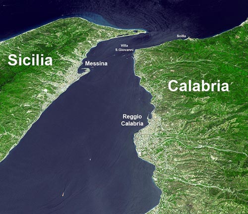
The Strait of Messina is, at its narrowest point, just 2 miles wide. A number of classical writers refer to a time when Sicily was still connected to Italy. In fact legend has it that Heracles was responsible for their separation. However, Cyprian Broodbank has pointed out in his monumental work, The Making of the Middle Sea, that “Today, the Messina strait dividing it (Sicily) from peninsular Italy is a minimum of 3 km (2 miles) wide and 72 metres (235 ft) in depth at its shallowest point. On the face of it, therefore, Sicily and mainland Italy should have fused under full glacial conditions. Yet this spot lies on a plate boundary and has already risen several metres over the last 150 years for which accurate measurements exist. Add a 127,000-71,000-year-old beach now elevated 90m (300ft) above the sea near the strait and we might start to wonder whether Sicily was ever solidly attached to the other land.”[1127.91] Nevertheless, he does suggest that early man possibly had stepping-stones in the form of islets and shallows between the two landmasses.
The Strait of Messina had a reputation in antiquity for having dangerous currents, which are thought to be the inspiration for Homer‘s sea monsters, Scylla and Charybdis. Heinrich Schliemann supported this identification[1243]. The currents there are still very dangerous, but nevertheless the strait is a busy waterway with both commercial and pleasure craft, indicating that the conditions there can be mastered. The hazards were situated at the northern end of the Strait, where today there is a town appropriately called Scilla on the Calabrian side.
The strait is sometimes offered as an earlier site for the Pillars of Heracles prior to the Western Mediterranean becoming more frequently navigated by the ancient Greeks, at which time the term was transferred to the Strait of Gibraltar. Winfried Huf is a keen supporter of ‘Pillars’ having been located at Messina. A constituent part of the Western Mediterranean was the Tyrrhenian Sea, which, for the Greeks, would have been most easily accessed through the Strait of Messina.
The earliest westward expansion of the Greeks was understandably to what became known as Magna Graecia in Sicily and southern Italy. The Phoenician expansion was along the north African coast eventually establishing Carthage at the Strait of Sicily. The ships available at that time were not designed for the open sea, but were usually kept within sight of land. I am inclined to think that the early Greeks would have had the Strait of Messina as the location of their Pillars of Heracles leading to the little known Western Mediterranean (or Tyrrhenian Sea), apparently referred to by some as the ‘Atlantic Sea’, whereas the Strait of Sicily might have led to conflict with the Phoenicians!
It is interesting that from around 330 BC and for nearly a thousand years(b) the Strait of Messina was known as Fretum Siculum, which translates as the Sicilian Strait. Philo of Alexandria (20 BC-50 AD) in his On the Eternity of the World(c) wrote “Are you ignorant of the celebrated account which is given of that most sacred Sicilian strait, which in old times joined Sicily to the continent of Italy?” (v.139).
>Alexander V. Podossinov in his paper on straits and their significance for the ancients commented “the Carthaginians for a long time did not permit the Greeks to pass through the Straits of Messina and had power over the whole western Mediterranean.”(d)<
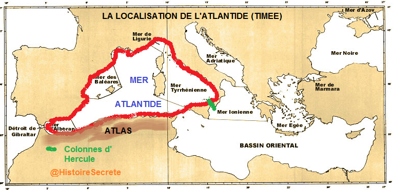
Support for the idea of the Western Mediterranean being the ‘Sea of Atlantis’ with the ‘Pillars’ at the Strait of Messina is presented on a French forum(a), which offers the map below.
(a) https://histoiresecrete.leforum.eu/t716-quelques-questions-se-poser-sur-le-Tim-e-Critias.htm
(b) https://pleiades.stoa.org/places/462494
Scheria
Scheria is the name of a Phaeacian island mentioned by Homer in his Odyssey and identified by some, including Ignatius Donnelly, as Atlantis. Scheria has been noted as only second to Atlantis for the array of locations ascribed to it. For example, Heinrich Schliemann, as well as many ancient and modern commentators, considered Scheria to have been Corfu. K. T. Frost, in the early part of the 20th century, associated Atlantis with Homer’s Scheria and both with the Minoan Empire, an idea also supported by Walter Leaf(l).
Others, such as Felice Vinci, suggest Norway, while Iman Wilkens[610] offers the Canaries.
A recent paper by Gerard Janssen, of Leiden University, also places Scheria in the Canaries, specifically on Lanzarote(f). This is one of an extensive series of papers by Janssen, which links Homer’s geography with locations in the Atlantic(g). An introductory paper(h) might be the best place to start.
An Atlantic location for Homer’s epic poems is advocated by N.R. De Graaf, the Dutch author of the Homeros Explorations website(i). Specifically, he also concluded that Scheria can be identified with Lanzarote in the Canaries, concurring with Wilkens and Janssen.
According to Pierluigi Montalbano, his native Sardinia was the Homeric land of the Phaeacians(j). Massimo Pittau offered the same conclusion “However the fact is that the Odyssey- as we have seen before – never mentions Sardinia. How, therefore, can this great and singular historical-documentary inconsistency be overcome? It can be overcome by assuming and saying that the poet of the Odyssey actually mentions Sardinia, but not calling it with his name, which will later become traditional and definitive, but with some other name relating to one of its regions or its population. And this is precisely my point of view, the one I am about to indicate and demonstrate: the poet of the Odyssey mentions Sardinia and its Nuragic civilization when he speaks of the «Scherìa or island of the Phaeacians».”(k)
Armin Wolf (1935- ), the German historian, suggests(b) that Calabria in Southern Italy was Scheria and even more controversially that the Phaeacians were in fact Phoenicians!
Wolf also claims[669.326] that although the country of the Phaeacians is in some translations called an island, the original Greek text never calls it ‘island’ just Scheria, which, Wolf informs us, etymologically means ‘continent’ – perfectly fitting Calabria. Even today, when people from Sicily go to Calabria, they say they are going to the ‘continente’. Wolf puts Scheria in the vicinity of Catanzaro, the capital of Calabria. It has been suggested to me in private correspondence(d) that the etymology of Catanzaro is strongly indicative of a Phoenician influence! Catanzaro is also  known as ‘the city of the two seas’, having the Tyrrhenian Sea to the west and the Ionian Sea to the east. It is Wolf’s contention that it was across this isthmus that Odysseus travelled[p.327].
A further mystery is that, according to Dr Ernst Assmann, quoted by Edwin Bjorkman, “both the vessel of Odysseus, as pictured in Greek art, and the term applied to it, are of Phoenician origin.”
Daniel Fleck(a) lists ten similarities between Scheria and Atlantis. Jürgen Spanuth[015] quoted and added to an even more extensive list of comparisons between the two compiled by R. Hennig. Rainer W. Kühne has also written a paper(c) on the similarities. Walter Leaf perceived a connection between the two and wrote accordingly[434]. Edwin Björkman went further and wrote a book[181] that linked Tartessos, Scheria and Atlantis. More recently, Roger Coghill stressed the similarity of Homer’s Scheria to Plato’s Atlantis in The Message of Atlantis [0494]. Additional comparisons are offered on the coda.io website(n).
Ernle Bradford notes that the name Scheria itself is thought by some to be derived from the Phoenician word ‘schera’, which means marketplace, which is not incompatible with Plato’s description of Atlantis as a hive of commercial activity. [1011.204]
Michael MacRae, in his Sun Boat: The Odyssey Deciphered[985] also thinks that Scheria could be identified with Atlantis and as such was probably situated at the western end of the Gulf of Cadiz near Portugal’s Cape Vincent. A number of 20th-century researchers, such as Sykes and Mertz, have placed the travels of Odysseus in the Atlantic. More recently, Gerard Janssen has followed this school of thought and as part of his theories, identifies Scheria as the island of Lanzarote in the Canaries (e).
This identification of Scheria with Atlantis has induced Eberhard Zangger, who advocates Atlantis as Troy, to propose that Troy is also Scheria![483]
However, Ernle Bradford, who retraced the voyage of Odysseus, voiced his view that Corfu was the land of the Phaeacians and noted that “the voice of antiquity is almost as unanimous about Scheria being Corfu as it is about the Messina Strait being the home of Scylla and Charybdis.”
A paper by John Black concluded with the following paragraph that fairly sums up what we actually know about the Phaeacians. “Who were the Phaeacians and where was their place of abode? No definite answers and no clues have been found,but their extraordinary seafaring abilities and the intriguing description by Homer make them appear to be either a fascinating advanced civilization of the past yet to be discovered, or a fiction of the imagination for the sake of a good story. It is worth mentioning that Homer’s description of Troy was also once considered to be a work of fiction. However, the city of Troy has now been discovered, turning myth into reality.” (m)
(a) http://web.archive.org/web/20250613012321/https://atlantipedia.ie/samples/archive-2087/
(b) Wayback Machine (archive.org)
(c) (PDF) Did Ulysses Travel to Atlantis? (researchgate.net)
(d) Private correspondence Jan. 2016
(e) https://www.homerusodyssee.nl/id16.htm
(f) https://www.academia.edu/38347562/ATLANTIC_SCHERIA_AND_THE_FAIAKANS_LANZAROTE_AND_THE_FAYCANS
(g) https://leidenuniv.academia.edu/GerardJanssen
(h) https://www.academia.edu/38537104/ATLANTIC_TROY
(i) https://www.homeros-explorations.nl
(k) Massimo Pittau – The Odyssey and Nuragic Sardinia (www-pittau-it.translate.goog)
(l) Miscellanea Homerica, VI, The Classical Journal, Vol. 23, No. 8 (May, 1928), pp. 615-617 (3 pages)
(m) https://www.ancient-origins.net/myths-legends/mythic-scheria-and-legendary-phaeacians-001034
(n) https://coda.io/@together/collective-research/homers-oddysey-atlantis-comparison-14
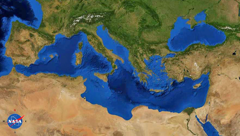
Mediterranean Sea
The Mediterranean Sea is at the heart of the Atlantis story. Solon brings the tale back from Egypt to Athens and relates how the Atlanteans controlled the Mediterranean as far as Tyrrhenia and Egypt. The Atlanteans then attacked Athens and Egypt. The exact extent of Egyptian-controlled territory at the time of Atlantis is unclear. One site(c) suggests that it stretched nearly as far as Syrtis Major, which some have proposed as the location of Atlantis.
The Atlanteans attack Athens and Egypt. Although the Pillars of Heracles are now generally believed to have been located at the Strait of Gibraltar, a number of other locations in the Mediterranean are known to have been similarly designated at different periods. As I have argued elsewhere, the Pillars of Heracles were undoubtedly a designation for the Strait of Gibraltar from the time of Eratosthenes. There is clear evidence that it was applied to other locations in earlier ages and probably over time, it became a metaphor for the limits of Greek maritime knowledge at any given period.
I may be the first to claim here that modern studies of Homer’s Odysseus offer a possible argument in favour of a Central Mediterranean Atlantis. Armin Wolf, the German historian, has made a 40-year study of 80 theories regarding the route taken by Odysseus. Around 30 of these included maps, some of which are included in Wolf’s book, Homers Reise: Auf den Spuren des Odysseus[669], a shorter version in English, including maps, is also available as a pdf file(a). It is obvious that although a reasonable degree of agreement exists between many of the theories regarding the position of the twelve specific locations recorded by Homer, those that confine the ‘wanderings’ to the Mediterranean, consistently keep all locations in the eastern basin and Central Mediterranean with the sole exception of the inclusion of Gibraltar which looks out of place on maps, with apparently nothing happening on the way there or on the return trip. Wolf’s carefully thought out route does not include Gibraltar and in my opinion, is a better reflection of actual Greek seafaring knowledge and naval capabilities at that time and adds a further suggestion, however inconclusive, that the Pillars of Heracles were situated in the Central Mediterranean. Wolfgang Geisthövel follows Wolf’s conclusions in Homer’s Mediterranean[1578].
Today’s leading theories regarding the location of Atlantis are virtually all related to the Mediterranean region. Between Morocco in the west and the Black Sea in the east, there is an embarrassment of suggested locations.
The principal objection to a Mediterranean location for Atlantis is frequently claimed to be the apparent physical extent of the island as described by Plato, which, if accepted as written, could not have fitted anywhere in that body of water. He gives us measurements for the plain adjacent to the city as being 240×360 miles. However, it is widely agreed that most of Plato’s dimensions are highly suspect and exaggerated by as much as a factor of ten.
On the other hand, if Atlantis had been located outside the Mediterranean, it is difficult to understand how the disaster that destroyed Atlantis could also have obliterated the Athenian army when the two locations would have been over 1700 miles apart. No single known natural disaster, such as earthquakes, could have affected the two cities at the same time as the text seems to imply. So if they were destroyed concurrently we must conclude that the two locations were situated in the same region and since Athens was clearly in the Mediterranean so must Atlantis have been. However, Plato does not explicitly say that the two armies were destroyed at the same time, although it seems to be implied.
As stated in the Invasion entry, all ancient empires expanded through the invasion of adjacent territories and so there is no good reason to think that Atlantis’ attack was not launched against an Athens that was within easy striking distance. This proximity could explain the inference that Atlantean and Athenian armies were destroyed simultaneously by some natural catastrophe!
Finally, please consider the following facts;
(1) Herodotus tells us that the ancient Greeks only knew of three continents, Asia, Europe and Libya (Africa) (Hist.4.42).
(2) Plato never called Atlantis a continent but consistently referred to it as an island.
(3) Finally, Herodotus also describes Sardinia as “the biggest island in the world.” (Hist.6.2)**, confirming a lack of knowledge of the world beyond the Mediterranean.
When all these details are taken together, they offer a compelling argument in favour of a Mediterranean Atlantis.
Sicily is larger in terms of area (25,708 v 24,090 km2). However, the coastal length of Sardinia is much greater than Sicily’s (1843 v 1115 km). Felice Vinci recently explained[019] how ancient seafarers measured territory by its coastal perimeter rather than by its area, as we do today. So Herodotus was correct according to the conventions of his day.
Cyprian Broodbank is a co-author with Giulio Lucarini of a paper(b) about Mediterranean Africa that “draws on a new surge in data to present the first up-to-date interpretative synthesis of this region’s archaeology from the start of the Holocene until the threshold of the Iron Age (9600–1000 bc).”
(a) Wayback Machine (archive.org)
(c) https://starshinetours.com/first-signs-of-weakening/ (link broken)