Mediterranean
Duane W. Roller
Duane W. Roller (1946- ) is an American archaeologist, author and professor emeritus of classics, Greek and Latin at the Ohio State University. Among his many published works is Through the Pillars of Herakles [1483] in which offers a new review of the early Greek and Roman exploration beyond the Mediterranean. The book was briefly reviewed in the New Yorker(a). 
In Through the Pillars of Herakles [p.203], he states that “The exact location of the Pillars of Herakles was long a matter of dispute. Although they may seem obvious today as the two large mountains at the western end of the Mediterranean, Gibraltar and Jebel Mousa, such was not the case in antiquity, and understanding of the region changed as topographical knowledge increased. At some early date, Homer’s mythical and unlocated Pillars of Atlas (Od. 1.51-4) became associated with the wanderer Herakles, but as the western end of the Mediterranean became better understood in the latter seventh century BC, uncertainty increased rather than decreased. Herodotus, who mentioned the Pillars several times, placed them east of Gadeira and Tartessos (4.8, 152), which could mean anywhere in the 50-kilometre-long strait (the modern Strait of Gibraltar) that runs east to the opening of the Mediterranean, through rugged topography with several promontories that could be identified as the Pillars, although especially prominent are Gibraltar and Jebel Mousa (the Kalpe and Abilyx of Strabo) at the eastern end. The early prominence of Gadeira caused some (such as Pindar) to place them in that area, or at points, east thereof, such as Tarifa or Cape Trafalgar: the sources seem uncertain as to whether height or prominence was the defining criterion.”
In an article in the Oxford Classical Dictionary, Roller noted that the name “Atlantic” (Greek Atlantikos or Atlantis) is not documented as applying to the ocean west of the inhabited world until the 5th century BC.
(a) https://www.newyorker.com/magazine/2006/04/24/through-the-pillars-of-herakles
Szymczyk, Mike
Michael Szymczyk (1981- ) “is an independent filmmaker, photographer, philosopher and novelist” and is the author of Atlantis & Its Fate In The Postdiluvian World [1964]. In it, he makes some extraordinary claims without providing any evidence. He pinpoints an underwater site near Kodiak Island off the northwest Pacific coast of Alaska as the location of Atlantis and then suggests that an Atlantean empire stretched all the way across America and the Atlantic to include all of the Mediterranean as far as Egypt. This ignores the fact that Plato only identifies, without ambiguity, southern Italy and part of North Africa along with some of the nearby islands as Atlantean territory. Zymczyk offers speculation rather than evidence to support these wild claims.
To add further confusion, the author includes further speculation regarding such matters as the possibility of ancient electronics, time travel and UFOs, sorry, UAPs. For me, the book lacks focus, as it tries to deal with Plato’s Atlantis, ancient technology, time travel and fails with all three.
Tuttle, Robert J.
Robert J. Tuttle (1935- ) is an American nuclear engineer and the author of The Fourth Source: Effects of  Natural Nuclear Reactors[1148], which is a ground-breaking review of “how the effects of nature’s own nuclear reactors have shaped the Earth, the Solar System, the Universe, and the history of life as we know it.”
This large volume (580 pages) challenges many accepted theories, such as glaciation, evolution, and mass extinctions and offers new ideas that will undoubtedly raise eyebrows(a).*The first 25 pages can be downloaded as a free pdf file.*
Surprisingly, Tuttle also tackles the question of Atlantis (p.301) suggesting the possibility that when sea levels were lower, the Balearic Islands in the Western Mediterranean were more extensive and possibly the home of Atlantis. He takes issue with Bury and Lee who refer to the ‘Atlantic Ocean’, which he claims should read as the ‘Sea of Atlantis’ and locates the ‘Pillars of Herakles’ somewhere between Tunisia, Sicily and the toe of Italy.
*(a) https://www.universal-publishers.com/book.php?method=ISBN&book=1612330770*
Krystek, Lee
Lee Krystek is on the staff of The College of New Jersey and is also the owner of the ‘unmuseum’ website(a). His site includes a section on Atlantis(b) which is fair and objective.
Krystek is not convinced by Donnelly’s Atlantic location and seems to think that the Minoan Hypothesis is the best theory current available, noting that “Not everyone accepts the Minoan Crete theory of the story of Atlantis, but until a convincing case can be made for some other place, it, perhaps, remains science’s best guess.”
As if hedging his bets, he concludes(c) his Atlantis comments with a link to Robert Ishoy’s Sardinian theory!
(a) https://www.unmuseum.org/unmain.htm
Yefremov, I. A.
 I. A. Yefremov (1908-1972) was a well-known Russian scientist and science-fiction writer. Nikolai Zhirov quotes[458.83] Yefremov, who saw the Mediterranean as the “cradle of all the great civilisations of antiquity such as those of Egypt and Atlantis” and believed that “it is not at all necessary to consider that the existence of an island in the Atlantic explains the continuity between the Mediterranean and American cultures.”
Atlantis II Deep (l)
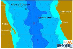
Atlantis II Deep is the name of the largest submarine basin in the Red Sea reaching a maximum depth of 7,160 feet where hot brine is produced at 56°C. The Red Sea is an extension of the Rift Valley and is in a tectonically active region.
Gene Matlock quotes Rajeswar Gupta(a), the Bengali historian, who states that the Red Sea and the Mediterranean had in earlier times been connected by a strait. Coincidentally, the controversial Oera Linda Book supports this contention(b).
(a) https://www.mondovista.com/ancientturks.html
(b) https://www.sacred-texts.com/atl/olb/olb29.htm
(p.105)
Armorica
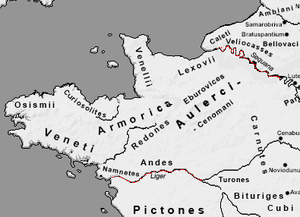
Armorica was the Latin name given by the Romans to what we know today as the Brittany peninsula. The region contains some of the most remarkable monuments created by the megalith builders, such as those found at Carnac and Morbihan,
 Plato described the influence of Atlantis reaching as far as Italy and Libya (Tim. 25b). In Europe megalithic structures have been found extending all along the Atlantic seaboard and into the Mediterranean as far east as Italy(a) and all across North Africa including modern Libya and Egypt, it was understandable when some commentators concluded that these megalithic monuments were a cultural expression of the Atlanteans. The evidence available indicates that the spread of megalithic building was effected by a maritime based society. How much of this spread was brought about through military or trade expansion or just migration is not known.
A number of French and German researchers have identified Brittany as the power centre of the Atlantean ‘confederation’, while the American writer Hank Harrison is working on a book in which he will nominate Morbihan as a possible capital of Atlantis. R. Cedric Leonard has also written an interesting article(b) on the megalithic monuments of Brittany.
While megaliths are also found in the Middle East and across Asia as far as Japan, their greatest concentration is in Western Europe with a suggested focal point in Armorica. The legendary sunken city of Ys, often associated with Atlantis, is reputedly located off the coast of Armorica.
(a) https://commons.wikimedia.org/wiki/Category:Megaliths_in_Italy
*(b) https://web.archive.org/web/20170113112315/https://www.atlantisquest.com/Carnac.html*
.
Mediterranean Sea Level
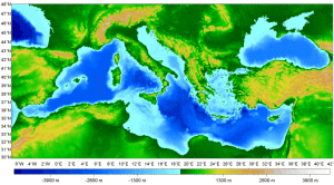
Mediterranean Sea Level. There is general acceptance that, on more than one occasion, the Strait of Gibraltar was closed completely. Tectonic plate movement, worldwide sea level drops due to the onset of Ice Age glaciation or a combination of both, could have caused this. There is also clear undisputed evidence that the Mediterranean Sea has dried out completely on a number of occasions. What is not clear is when the last desiccation or partial drying-out of the Mediterranean ended. The conventional date given for the last breaching of a Gibraltar Dam is 5 million years ago. However, there is a small but growing opinion that there was a more recent breach of a dam within the memory of modern man and preserved in history and myth.
>Not only have sea levels changed, but a 2020 report has now offered evidence that the Mediterranean was over three degrees hotter 2,000 years ago and that it remained hotter for about 500 years during the time of the Roman Empire(c).<
 Where one theory on the location of Atlantis is concerned, the existence of a Gibraltar dam before the end of the last Ice Age is critical, namely that Atlantis was situated near modern Cyprus. The site chosen by author Robert Sarmast is 1650 metres beneath the present level of the Mediterranean. His theory is totally dependent on proving the existence of this dam. It would seem prudent to have carried out a more detailed study of the evidence for a relatively recent removal of the dam before engaging in a very costly exploration over a mile under the eastern Mediterranean.
There are a number of facts that appear to suggest a more recent Mediterranean inundation but even collectively they do not offer any more than circumstantial evidence.
(i) The Mediterranean sea level must have dropped by as much as from 150 to 300 meters or more. Several years ago, by chance divers found submerged entrances (below sea level) in Southern France, which subsequently led them to discover the now famous prehistoric cave paintings there. There are many man-made stone structures around the Mediterranean that are now under water as well.
Cosquer Cave, near Marseilles, has its entrance 37 metres underwater. It contains several dozen works painted between 25000-17000 BC. The opening was once several miles inland until about 10000 BC when the sea began to rise at the end of the last Ice Age. It has been estimated that that it was originally at a height of 80 metres above sea level, according to anthropologist, James Q. Jacobs(a). This cave art depicts the Auk, which had never been found this far north.
(ii) Submerged Maltese structures, although their inundation may have been caused by local seismic activity rather than global sea level changes.
(iii) H. S. Bellamy claimed[091] that ancient geographers hinted at the non-existence of the Strait of Gibraltar within human memory.
(iv) A modern Guide to Provence(b) also claims a relatively recent removal of the Gibraltar land bridge.
(v) Medieval Arab writers such as Al-Biruni, Al-Idrisi and Al-Mas’udi suggest the existence of a Gibraltar landbridge, again within the memory of man.
(vi) The sunken port of ancient Syedra in Turkey.
(a) http://www.jqjacobs.net/rock_art/dawn.html
(b) Landmark Visitors Guide – Provence & Côte D’Azure by Richard Sale. (p.16)
>(c) https://www.ancient-origins.net/news-history-archaeology/mediterranean-sea-temperature-0014032<
Mediterranean Sea
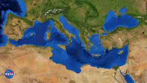
The Mediterranean Sea is at the heart of the Atlantis story. Solon brings the tale back from Egypt to Athens and relates how the Atlanteans controlled the Mediterranean as far as Tyrrhenia and Egypt. The Atlanteans then attacked Athens and Egypt. The exact extent of Egyptian-controlled territory at the time of Atlantis is unclear. One site(c) suggests that it stretched nearly as far as Syrtis Major, which has been proposed by some as the location of Atlantis.
The Atlanteans attack Athens and Egypt. Although the Pillars of Heracles are now generally believed to have been located at the Strait of Gibraltar, a number of other locations in the Mediterranean are known to have been similarly designated at different periods. As I have argued elsewhere, the Pillars of Heracles were undoubtedly a designation for the Strait of Gibraltar from the time of Eratosthenes, there is clear evidence that it was applied to other locations in earlier ages and probably over time, it became a metaphor for the limits of Greek maritime knowledge.
I may be the first to claim here that modern studies of Homer’s Odysseus offer a possible argument in favour of a Central Mediterranean Atlantis. Armin Wolf, the German historian, has made a 40-year study of 80 theories regarding the route taken by Odysseus. Around 30 of these included maps, a number of which are included in Wolf’s book, Homers Reise: Auf den Spuren des Odysseus[669], a shorter version in English, including maps, is also available as a pdf file(a). It is obvious that although a reasonable degree of agreement exists between many of the theories regarding the position of the twelve specific locations recorded by Homer, those that confine the ‘wanderings’ to the Mediterranean, consistently keep all locations in the eastern basin and Central Mediterranean with the sole exception of the inclusion of Gibraltar which looks out of place on maps, with apparently nothing happening on the way there or on the return trip. Wolf’s carefully thought out route does not include Gibraltar and in my opinion, is a better reflection of actual Greek seafaring knowledge and naval capabilities at that time and adds a further suggestion, however inconclusive, that the Pillars of Heracles were situated in the Central Mediterranean. Wolfgang Geisthövel follows Wolf’s conclusions in Homer’s Mediterranean[1578].
Today’s leading theories regarding the location of Atlantis are virtually all related to the Mediterranean region. Between Morocco in the west and the Black Sea in the east, there is an embarrassment of suggested locations.
The principal objection to a Mediterranean location for Atlantis is frequently claimed to be the apparent physical extent of the island as described by Plato, which if accepted as written, could not have fitted anywhere in that body of water. He gives us measurements for the plain adjacent to the city as being 240×360 miles. However, it is widely agreed that most of Plato’s dimensions are highly suspect and exaggerated by as much as a factor of ten.
On the other hand, if Atlantis had been located outside the Mediterranean it is difficult to understand how the disaster that destroyed Atlantis could also have obliterated the Athenian army when the two locations would have been over 1700 miles apart. No single known natural disaster, such as an earthquake, could have affected the two cities at the same time as the text seems to imply. So if they were destroyed concurrently we must conclude that the two locations were situated in the same region and since Athens was clearly in the Mediterranean so must Atlantis. However, Plato does not explicitly say that the two armies were destroyed at the same time, although it seems to be implied.
As stated in the Invasion entry, all ancient empires expanded through the invasion of adjacent territories and so there is no good reason to think that Atlantis’ attack was not launched against an Athens that was within easy striking distance. This proximity could explain the inference that Atlantean and Athenian armies were destroyed simultaneously by some natural catastrophe!
Finally, please consider the following facts;
(1) Herodotus tells us that the ancient Greeks only knew of three continents, Asia, Europe and Libya (Africa) (Hist.4.42).
(2) Plato never called Atlantis a continent but consistently referred to it as an island.
(3) Finally, Herodotus also describes Sardinia as “the biggest island in the world.” (Hist.6.2)**, confirming a lack of knowledge of the world beyond the Mediterranean.
When all these details are taken together they offer a compelling argument in favour of a Mediterranean Atlantis.
** Sicily is larger in terms of area (25,708 v 24,090 km2). However, the coastal length of Sardinia is much greater than Sicily’s (1843 v 1115 km). Felice Vinci recently explained[019] how ancient seafarers measured territory by its coastal perimeter rather than by its area, as we do today. So Herodotus was correct according to the conventions of his day.
Cyprian Broodbank is a co-author with Giulio Lucarini of a paper(b) about Mediterranean Africa that “draws on a new surge in data to present the first up-to-date interpretative synthesis of this region’s archaeology from the start of the Holocene until the threshold of the Iron Age (9600–1000 bc).”
(a) Wayback Machine (archive.org)
(c) https://starshinetours.com/first-signs-of-weakening/ (link broken) *
Hébert, Jacques
Jacques Hébert is the author of Atlantide: La Solution Oubliee[373] concerning Atlantis. As a former Parisian police  chief, he claims to have applied his skills in that field to solving the mystery of Plato’s island. He critically re-examines the original text and offers an interpretation that he believes provides a more rational and harmonious reading of the narrative. His conclusion is that Atlantis lay in the Indian Ocean and that its culture was derived from the Indus valley. He specifically identifies the Yemeni island of Socotra as part of the Atlantean civilisation
Hébert postulates that this empire had at least trade connections in the eastern Mediterranean and quite possibly had a colony in the region that produced the predecessors of the Phoenicians.
Hébert identifies Bab el Mandeb as Plato’s Pillars of Heracles, by assuming that Solon mistook the description of that strait, given to him by the priests of Sais, with the Strait of Gibraltar, which has similar features. The earthquake that destroyed Atlantis is attributed by him to a close encounter with an extraterrestrial body.
A 2004 interview with Hébert can be read online(a).
(a) Wayback Machine (archive.org) (French)
JACQUES HÉBERT OR THE NEW ATLANTIS – vox-populi.net (web-archive-org.translate.goog) (English)


