Latest News

Joining The Dots
I have now published my new book, Joining The Dots, which offers a fresh look at the Atlantis mystery. I have addressed the critical questions of when, where and who, using Plato’s own words, tempered with some critical thinking and a modicum of common sense.Read More »
François Roudaire
Chott el Jerid
Chott el Jerid is one of a series of ancient salt lakes (sometimes spelt shott or shat) in Tunisia that stretches from the Gulf of Gabés westward into Algeria, south of the Atlas Mountains. It is the second-largest salt lake in the world after Salt Lake in Utah. It is maintained that ancient Lake Tritonis was located in this region and possibly incorporated Chott el Jerid and at some point may even have extended as far as an enlarged Lake Chad.
These chotts are not, strictly speaking, lakes at all today. They are flat, depressed areas, which for most of the year are areas of dried mud covered with a thick skin of salt, suggesting an earlier connection with the Mediterranean.
The principal chotts are Chott el Djerid, Chott ech Chergui, Chott Melrhir, Chott el Fejej and Chott el Hodna.
The largest, the Chott el Jerid, is just a few feet below the level of the ![chott_el_jerid[1]](https://atlantipedia.ie/samples/wp-content/uploads/2010/06/chott_el_jerid11.jpg) Mediterranean, according to Wikipedia. However, François Roudaire, a 19th-century French geographer, surveyed the chott and reported that the entire salt lake was 15 metres above the level of the Mediterranean. This fact was confirmed by Edward Dumergue in his 1883 booklet, The Chotts of Tunis[659]. In the same publication [p.5] he mentions Roudaire “showing how these chotts could be formed into one great inland sea, extending from near Biskra and Chegga in Algeria, through Tunis, to the Gulf of Gabes, about 300 miles in length and about 60 in breadth, forming a new gulf into the Mediterranean, with an area somewhat greater than the Irish Sea.”
Mediterranean, according to Wikipedia. However, François Roudaire, a 19th-century French geographer, surveyed the chott and reported that the entire salt lake was 15 metres above the level of the Mediterranean. This fact was confirmed by Edward Dumergue in his 1883 booklet, The Chotts of Tunis[659]. In the same publication [p.5] he mentions Roudaire “showing how these chotts could be formed into one great inland sea, extending from near Biskra and Chegga in Algeria, through Tunis, to the Gulf of Gabes, about 300 miles in length and about 60 in breadth, forming a new gulf into the Mediterranean, with an area somewhat greater than the Irish Sea.”
It is worth noting that Diodorus Siculus records that around 1250 BC, catastrophic seismic activity across North-West Africa from the Gulf of Gabés to the Atlantic radically changed the topography of the region. Some investigators see this event as being responsible for the cutting-off of these inland seas from the Mediterranean, creating today’s salt lakes. This idea is not as fanciful as it might seem at first sight when you consider the geological instability of the Central Mediterranean region. A well-known example is to be found at the Macellum of Pozzuoli near Naples which has been rising and falling over the past two millennia, due to movements in the volcanic caldera on which it sits.
Wintertime can produce up to a metre of water in these chotts, which, by liquefying the mud, makes them perfectly impassable. There is a clear suggestion that these chotts represent an inland sea that was once connected to the Mediterranean. It is believed that seismic activity in the area cut this connection. All around these salt lakes, there are numerous springs, rushing from the sandy hillocks. Virtually all these springs are very near boiling point. The town of Gabés is close to a grand oasis, which is maintained by water from a stream emptying itself into the sea at Gabés after a short run.
More than one writer has placed Atlantis in this region. Paul Borchardt and Albert Hermann in the early 1920s and more recently Alberto Arecchi, have advocated this idea. Borchardt reported that the local name of Chott el Jerid was Bahr Atala or Sea of Atlas.
Arecchi concurs with this explanation and is convinced that the inland sea was the original ‘Atlantic Ocean’. He quotes the Book of Jubilees to support this contention(a).
In 2020, David Winder published Mysterien der Bronzezeit (Mysteries of the Bronze Age) [1936] in which he firmly locates Atlantis in the region of Chott- el-Jerid. In an article on the Atlantisforschung website, he expands on his theory and includes a chronology of key events in the 2nd millennium BC(f).
A year late, Hong-Quan Zhang also placed Atlantis firmly within what is now the northwest region of Africa, specifically identifying the capital’s location at the eastern end of Chott el Jerid in modern Tunisia(e).
In 2021, Aleksa Vuckovic reviewed the history of the suggestion of Atlantis being located in the region of the chotts, but does not appear convinced that such is the case(g).
A contributor to a June 2012 forum(b) provided a link(c) to an interesting satellite image, as well as the following list of fifteen points favouring the chotts as a location for Atlantis:
1) Atlantis did not sink to “the bottom of the ocean”, instead it became a “muddy shoal only several feet below the water surface”
2) It’s to the West of both Egypt and Greece
3) The Chotts used to be a large “mega-lake” and you can use a sea-level map to simulate how large this lake used to be
4) That mega-lake is very likely to be the mythical “Lake Tritonis” that the Greeks ascribed to this area
5) Herodotus spoke of Tritonis in relation to the peoples near Mount Atlas who referred to themselves as Atlanteans
6) There are Carthaginian coins from this area with Elephants (and older petroglyphs with Elephants and diverse fauna)
7) One phase of the local art was highly similar to the Minoan\Sea Peoples influence
8) The local Deity is syncretically equal to Neith (who was deemed syncretically equal to Athena by Egypt in the tale)
9) Another local Deity is syncretically equal to Poseidon
10) The tale of the Amazons is corroborated genetically from Tuscany to Corfu to this Region (the Amazons fought the Atlanteans)
11) The Berbers often claim to have a heritage from Atlantis (not a big deal, so does half the Mediterranean and South America… etc)
12) Several ancient sources claim that this “mega-lake” emptied via a geological cataclysm. The event precedes the Sea Peoples epoch.
13) The name ‘Gabes’ is arguably linguistically closer to ‘Gades’ than Cadiz (Spain).
14) Gafsa (Caspa) was legendarily the home of the Libyan Herakles and resided between two mountains
15) It’s closer proximity to Egypt and Greece makes it more plausible as a Bronze Age power than Gibraltar, where it would be essentially like living on the moon in that age. (In no order).
A strong case advocating the Chotts as the most likely location of Atlantis has been put forward by Alan Mattingly. In his book Plato’s Atlantis and the Sea Peoples [1948], , he proposes that the Atlantis story “was actually based upon a version of the Libyo-Sea People’s attacks on the Egyptian state during the reigns of Merneptah and Ramesses III. And further, that the Libyan contingent of the said attacks ultimately derived from a base in and around the region of Tunisia and Algeria between the Isle of Djerba and the town of Biskra, a region known to us as the ‘Chotts’ or ‘Djerid’”.
(a) https://www.liutprand.it/articoliMondo.asp?id=430
(b) https://forums.thedarkmod.com/topic/13909-what-is-your-favorite-historical-mystery/
(c) https://mapper.acme.com/?ll=33.96187,9.80800&z=17&t=S&marker0=33.70000%2C8.43000%2CChott%20el%20Djerid&marker1=33.96187%2C9.80800%2C6.9%20km%20N%20of%20El%20Hamma
(e) https://medcraveonline.com/IJH/is-atlantis-related-to-the-green-sahara.html
(f) Atlantis: From Myth to Reality – Atlantisforschung.de (atlantisforschung-de.translate.goog)
(g) https://www.ancient-origins.net/ancient-places-africa/tunisian-atlantis-0016130
Gabés, Gulf of
Gulf of Gabés on the eastern coast of Tunisia was formerly known as Syrtis Minor. Today is contains the Tunisian oil reserves and has the distinction of having one of the few significant tidal ranges (max. 8 feet) in the Mediterranean, which exposes extensive sandbanks at low tides(b).
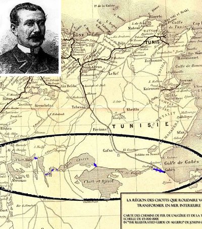
Roudaire’s proposed channels marked in blue
Inland from the Gulf are the salt marshes or chotts that originally constituted an inland sea, possibly Lake Tritonis, connected with the Mediterranean, but due to a seismic upheaval, a ridge was created separating them from the outer sea. A comparable event was the 2011 Fukushima earthquake which moved the seafloor 16 meters vertically and 50 metres laterally(a).
In the 19th century François Roudaire proposed the cutting of a channel from the Gulf of Gabés to the chotts, recreating the former inland sea(c).
His plan was supported by Ferdinand de Lesseps (1805-1894), who developed the Suez Canal. However, when Roudaire surveyed the chott nearest the sea, Chott el-Djerid, he discovered that it was in fact lying significantly above sea level. This forced him to revise the scale of the plan, which in turn, began the erosion of support for the project, which was eventually abandoned.
It is interesting that the idea of creating a vast inland sea in the Sahara has been been raised again(d) in the context of the current climate change, which, if unchecked, will raise sea levels dramatically. The objective of this new inland sea would be to partly offset this sea level rise.
Férréol Butavand was one of the first to locate Atlantis in the Gulf of Gabés[205]. In 1929 Dr. Paul Borchardt, the German geographer, claimed to have located Atlantis between the chotts and the Gulf. Dr. Anton Mifsud has drawn attention[209] to the writings of the Greek author, Palefatus of Paros, who stated (cap. 32) that the Columns of Heracles were located close to the island of Kerkenna, at the western end of Syrtis Minor.
Alberto Arecchi has built on the earlier work of Butavand and places Atlantis firmly in the Gulf(e) when sea levels were much lower as a result of an isthmus separating Eastern from Western Mediterranean.
George Sarantitis delivered three papers to the 2008 Atlantis Conference, also locating the Pillars of Heracles in the Gulf of Gabés, which led to the ‘Atlantic Sea in modern Tunisia and Algeria, south of the Atlas Mountains and the site of Atlantis.
In 2021, Alan Mattingly published Plato’s Atlantis and the Sea Peoples [1948] as a Kindle ebook. In my opinion, this is one of the better Atlantis books of recent years, offering a more forensic look at Plato’s Atlantis texts. He has noted that a “Close reading of Herodotus also locates a feature he calls the Pillars of Herakles, other than the more famous ones at the Straits of Gibraltar, at some point in the Little Syrtis before Carthage is reached; in this case, they were almost certainly at Meninx on the island of Djerba.” [Loc.885]
(a) https://www.scientificamerican.com/article/japan-earthquake-moves-seafloor/
(b) https://www.britannica.com/place/Gulf-of-Gabes
(c) https://bigthink.com/strange-maps/617-the-sahara-sea-a-french-mirage-in-north-africa
(d) Emancipatory Oceanic Macro-engineering Richard B. Cathcart http://web.archive.org/web/20220120071604/https://atlantipedia.ie/samples/archive-5079/