Latest News

Joining The Dots
I have now published my new book, Joining The Dots, which offers a fresh look at the Atlantis mystery. I have addressed the critical questions of when, where and who, using Plato’s own words, tempered with some critical thinking and a modicum of common sense.Read More »
Lake Chad
Sarantitis, George
George Sarantitis (1954- ) was born in Athens and is by profession an electronics  engineer. He is also a serious student of Ancient Greek history and literature whose research(a) enabled him to present three papers to the 2008 Atlantis Conference. These included a revised translation of many of the keywords and phrases in Plato’s Atlantis texts. He quotes Strabo’s Geographica (3.5.5.20) to demonstrate the multiplicity of locations on offer for the Pillars of Heracles. He places Atlantis in North Africa at the Richat Structure, with the Pillars of Heracles situated in the Gulf of Gabes which formerly led to an inland sea where the chotts of Tunisia and Algeria are today, as well as a number of other lakes and rivers in what is now the Sahara.
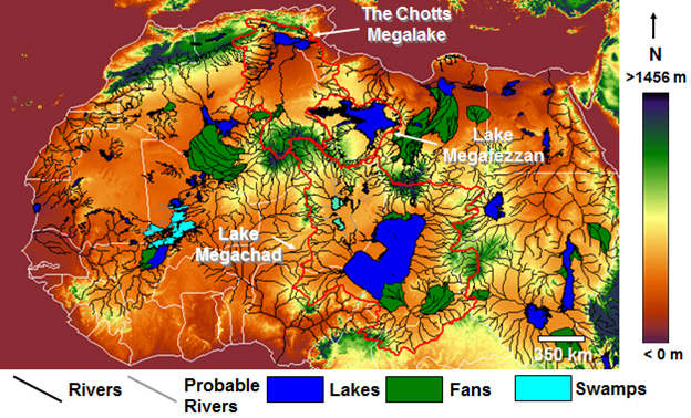
He posits a number of large inland seas in Africa including a much larger Lake Chad(f). The 2014 May/June edition of Saudi Aramco World has an article(c) on the remnants of the ‘Green Sahara’, during what is known technically as the African Humid Period (9000-3000 BC). Sarantitis also claims that at one stage in the distant past Libya had been a peninsula. In a June 2015 report the University of Royal Holloway in London revealed that the size of Lake Chad was dramatically reduced in just a few hundred years(d). A similar map showing enormous inland North African lakes 13,000 years ago are included in Taylor Hansen’s The Ancient Atlantic [0527.36].
Sarantitis offers details of his theories on his extensively illustrated Plato Project website(a), which I wholeheartedly recommend readers to visit. He includes a rather technical forensic analysis of Plato’s use of myth. Sarantitis also suggests that the ‘unfinished’ Critias is in fact continued at the beginning of Homer’s Odyssey (1.32-34).
Some of Sarantitis’ sections on the Methodology of Mythology will be difficult for non-academic readers, such as myself, to fully comprehend. For me, his proposal that there were two Atlantean Wars, which took place in 9600 BC and 8600 BC(e) is extremely difficult to accept, since those wars were with Athens and Egypt that did not even exist at those dates! I find it difficult to accept this apparent abandonment of commonsense and the science of archaeology.
In 2010, Sarantitis published his theories in The Apocalypse of a Myth in Greek. Now (2017) that work has been translated into English and is currently being prepared for publication with a new title of Plato’s Atlantis: Decoding the Most Famous Myth.
There is now an extensive video clip Q & A session available on Sarantitis’ website(b).
Sarantitis’ theories have been been given additional exposure with a new 2024 Jack Kelley documentary entitled The Atlantis Code that is now available on Amazon and YouTube. The official website for the film includes a number of interviews with Kelley and other commentators(g).
Thorwald C. Franke has highlighted in his newsletter No. 225 one of the fundamental errors in Sarantitis’ theory is his claim that Atlantis as the Richat Structure existed around 10,000 BC. Franke provides a link to an earlier paper debunking this idea(h). I fully concur with Franke and would add that no one has explained how Atlantis in West Africa could attack Athens millennia before it existed. Not only is the suggestion plain silly, but the proposal that 12,000 years ago, when little more than logboats(i) existed, an attack was launched on a non-existent Athens, nearly 4000 km away by land (3000 km by sea) from the ‘Structure’, is pure nonsense.
(a) Plato Project – Timeus & Critias: The ultimate explanation (archive.org)
(b) FAQ’s – Plato Project (archive.org)
(c) https://archive.aramcoworld.com/issue/201403/last.lakes.of.the.green.sahara.htm
(e) Proceedings of the 2008 Atlantis Conference[750.389](editor S.Papamarinopoulos)
(f) https://www.sciencedaily.com/releases/2015/06/150629162542.htm *
(g) https://www.empirebuilderproductions.com/the-atlantis-puzzle *
(h) https://www.atlantis-scout.de/atlantis-10000-bc-engl.htm *
(i) https://hakaimagazine.com/news/uncovering-culture-bronze-age-logboats/ *
Sahara Desert
The Sahara Desert and in particular its northern regions have attracted its share of attention from Atlantis investigators. However unlikely it may appear as a possible location for Atlantis it must be kept in mind that the Sahara of prehistory was very different from what we see today. Not only was it wetter at various periods in the past, but also there is clear evidence for the existence of a large inland sea extending across the borders of modern Algeria and Tunisia. This evidence is in the form of the chotts or salt flats in both countries. This proposed sea is considered by some to have been the Lake Tritonis referred to by classical writers. It is suggested that some form of tectonic/seismic activity, common in the region, was responsible for isolating this body of seawater from the Mediterranean and eventually turning it into the salt flats we see today.
An even more extensive inland sea, further south, was proposed by Ali Bey el Abbassi and based on his theory a map was published in 1802 which can be viewed online(c).
More recently, Riaan Booysen has published an illustrated paper on the ancient inland Saharan seas as indicated on the 16th-century maps of Mercator and Ortelius(i). King’s College London runs The Sahara Megalakes Project which studies the Megalakes and the Saharan Palaeoclimate record(m). The largest of these was possibly Lake Chad which at its most extensive is estimated to have been greater than the combined Great Lakes of North America.
 A 2013 report in New Scientist magazine(d) revealed that 100,000 years ago the Sahara had been home to three large rivers that flowed northward, which probably provided migration routes for our ancestors. Depending on how long the African Humid Period lasted, this article may be read in conjunction with George Sarantitis‘ theory regarding the Voyage of Hanno that he claims took place in the interior of Africa.
Other studies(h) have shown the previous existence of a huge river system in the Western Sahara, which flowed into the Atlantic on the Mauritanian coast.
An article in the Sept. 2008 edition of National Geographic pointed out that the Saharan climate has been similar for the past 70,000 years except for a period beginning 12,000 years ago when a number of factors combined to alter this fact. A northerly shift by seasonal monsoons brought additional rain to an area the size of the contiguous USA. This period of a greener Sahara lasted until around 4,500 years ago.
More recent studies claim that “there’s geologic evidence from ocean sediments that these orbitally-paced Green Sahara events occur as far back as the Miocene epoch (23 million to 5 million years ago), including during periods when atmospheric carbon dioxide was similar to and possibly higher than today’s levels. So, a future Green Sahara event is still highly likely in the distant future.” (p)
However, in the Sept. 2024 edition of National Geographic an article Peter Gwin notes that “the Sahara hasn’t always been a desert. In fact, it transforms from desert to lush savanna about every 21,000 years. A quirk in Earth’s planetary mechanics periodically causes its axis to tilt slightly, increasing the amount of radiation directed to the Northern Hemisphere, which in turns pulls Africa’s seasonal rains northward.”
Henri Lhote contributed an article to Reader’s Digest‘s, The World’s Last Mysteries [1083], regarding the ‘green’ Sahara that existed prior to 2500 BC. Two German climatologists Rudolph Kuper and Stefan Kröpelin have estimated that this last greening of the Sahara began around 8500 BC and ended sometime between 3500 BC and 1500 BC(r)(u) .
A team from the Potsdam Institute for Climate Research led by Professor Martin Claussen published a number of papers in the late 1990s following their production of a successful computer simulation of prehistorical North Africa(v). According to a report on the climateark website (now offline), one of their conclusions was “that the change to desert climate in the Sahara was triggered by changes in the Earth’s orbit and the tilt of Earth’s axis.”
Some, such as Kröpelin, have suggested a connection between the latest aridification of the Sahara and the migration of settlers to the Nile Valley(w), where, coincidentally, the ancient Egypt we know about was founded around 3100 BC.
Others have endeavoured to link the last drying of the Sahara with the destruction of Atlantis!
More recently, human activity has been blamed as a major contributory factor for the desertification of the Sahara region less than 10,000 years ago.(n)
Related to the above is a recent study of sediments off the west coast of Africa, which resulted in the discovery of what was “primarily a new “beat,” in which the Sahara vacillated between wet and dry climates every 20,000 years, in sync with the region’s monsoon activity and the periodic tilting of the Earth.” (o)
In Mauritania, a huge natural feature known as the Richat Structure has been claimed as the remnant of Atlantis by George Sarantitis [1470] as well as by Alexander & Rosen and others. However, Ulf Richter has pointed out that it is too wide (35km), too elevated (400metres) and too far from the sea (500km) to be seriously considered as the location of Atlantis. Apart from which, a scientific study of the Structure reveals it to be a natural feature(x).
In 1868, it was proposed by D.A. Godron, the French botanist, that the Sahara was the location of Atlantis. In 2003, the non-existent archaeologist Dr.Carla Sage announced that she was hoping to lead an international expedition to the Sahara in search of Atlantis. Her contention was that “Atlantis was the capital of a vast North African empire with ports on the Gulf of Sidra”. This report is now confirmed to have been a hoax! I am indebted to Stel Pavlou for uncovering the origin of this story(e).
The idea of an African Atlantis was highlighted in 2021 with the publication of Atletenu [1821], in which the author, Diego Ratti, identified the Hyksos as Atlanteans with their capital at Avaris in the eastern Nile Delta. At the other end of North Africa, the chotts of Tunisia and Algeria were nominated by Holden Zhang as the location of Atlantis in a YouTube clip(q).
Gary Gilligan, the well-known catastrophist, wrote a thought-provoking article(k) on the origin of the Saharan sands, which he claims are extraterrestrial in origin and expands on the idea in his 2016 book Extraterrestrial Sands [1365]. A March 2024 report(t). on the BBC website has revealed that a particular type of sand dune has now been dated. They are known as ‘star’ or ‘pyramid’ dunes – “are named after their distinctive shapes and reach hundreds of metres in height.” They are found in Africa, Asia and North America, as well as on Mars – but experts had never before been able to put a date on when they were formed. Now scientists have discovered that a dune called Lala Lallia in Morocco formed 13,000 years ago.”
David Mattingly, an archaeologist at Leicester University has found that an ancient people known as the Garamantes had an extensive civilisation in the Sahara(l). He has evidence of at least three cities and twenty other settlements. The Garamantes reached their peak around 100 BC and then gradually diminished in influence as fossil water supplies reduced until in the 7th century AD they were subjected to Islamic domination. Some researchers such as Frank Joseph have identified the Garamantes as being linked with the Sea Peoples. Bob Idjennaden has published short but informative Kindle books about both the Garamantes [1194] and the Sea Peoples [1195], without a suggestion of any connection between the two.
A 2017 article on the Popular Archaeology website told us that “New research investigating the transition of the Sahara from a lush, green landscape 10,000 years ago to the arid conditions found today, suggests that humans may have played an active role in its desertification.” (n).
The discovery of megalithic structures discovered at Nabta Playa (Nabta Lake) in the Egyptian Sahara has provided evidence for the existence of a sophisticated society in that area around 5000 BC. In the same region, near the Dakhleh Oasis, archaeologists have produced data that supports the idea that pre-Pharaonic Egypt had Desert Origins rather than being an importation from Mesopotamia or elsewhere(a).
Nabta Playa is not unique, in fact, the largest megalithic ellipse in the world is to be found at Mzorah, 27 km from Lixus in Morocco(b). It appears that the construction methods employed at both Mezorah and Nabta Playa are both similar to that used in the British Isles. An even more impressive site is Adam’s Calendar in South Africa which has been claimed as 75,000-250,000 years old.
West of Cairo near the border with Libya is the Siwa Oasis, where it has now been demonstrated that “it is in fact home to one of Ancient Egypt’s astounding solar-calendar technologies– the solar equinox alignment between the Timasirayn Temple and the Temple of Amun Oracle in Aghurmi.”(j).
I think we can expect further exciting discoveries in the Sahara leading to a clearer picture of the prehistoric cultures of the region and what connections there are, if any, with Plato’s Atlantis. In the meanwhile in the Eastern Egyptian Desert, Douglas Brewer, a professor of archaeology at the University of Illinois, has discovered over 1,000 examples of rock art, including numerous depictions of boats although the sites, so far undisclosed, are remote from water.
Even more remarkable is the report(e) of March 2015 that a survey of the Messak Settafet escarpment in the central Sahara revealed that there were enough discarded stone tools in the region “to build more than one Great Pyramid for every square kilometre of land on the continent”! Coincidentally, around the same time, it was reported that over a thousand stone tools had been found in the Northern Utah Desert(g). What the Utah discovery lacked in quantity was made up for in quality with the finding of the largest known Haskett point spearhead, measuring around nine inches in length.
(a) Saudi Aramco World (2006, Vol. 57, No.5 p.2-11)
(c) https://web.archive.org/web/20201019061756/http://catalog.afriterra.org/zoomMap.cmd?number=1036
(d) NewScientist.com, 16 September 2013, https://tinyurl.com/mg9vcoz
(f) https://www.cam.ac.uk/research/news/saharan-carpet-of-tools-is-the-earliest-known-man-made-landscape
(i) 7. The lakes in the middle of the Sahara desert – Page 8 (archive.org)
(l) http://web.archive.org/web/20191216194846/https://atlantipedia.ie/samples/archive-3268/
(n) https://popular-archaeology.com/issue/winter-2017/article/did-humans-create-the-sahara-desert
(o) https://phys.org/news/2019-01-sahara-swung-lush-conditions-years.html#jCp
(p) https://www.livescience.com/will-sahara-desert-turn-green.html
(q) Revive Eden 3 Convincing Atlantis – YouTube
(r) (Smithsonian. Feb 2010) https://www.smithsonianmag.com/history/uncovering-secrets-of-the-sphinx-5053442/
(s) https://las.illinois.edu/news/2006-09-01/oasis-art-egyptian-desert
(t) (BBC Mar.4, 2024) Star dune: Scientists solve mystery behind Earth’s largest desert sands – BBC News
(u) Shift From Savannah to Sahara Was Gradual, Research Suggests – The New York Times (nytimes.com)
Chott el Jerid
Chott el Jerid is one of a series of ancient salt lakes (sometimes spelt shott or shat) in Tunisia that stretches from the Gulf of Gabés westward into Algeria, south of the Atlas Mountains. It is the second-largest salt lake in the world after Salt Lake in Utah. It is maintained that ancient Lake Tritonis was located in this region and possibly incorporated Chott el Jerid and at some point may even have extended as far as an enlarged Lake Chad.
These chotts are not, strictly speaking, lakes at all today. They are flat, depressed areas, which for most of the year are areas of dried mud covered with a thick skin of salt, suggesting an earlier connection with the Mediterranean.
The principal chotts are Chott el Djerid, Chott ech Chergui, Chott Melrhir, Chott el Fejej and Chott el Hodna.
The largest, the Chott el Jerid, is just a few feet below the level of the ![chott_el_jerid[1]](https://atlantipedia.ie/samples/wp-content/uploads/2010/06/chott_el_jerid11.jpg) Mediterranean, according to Wikipedia. However, François Roudaire, a 19th-century French geographer, surveyed the chott and reported that the entire salt lake was 15 metres above the level of the Mediterranean. This fact was confirmed by Edward Dumergue in his 1883 booklet, The Chotts of Tunis[659]. In the same publication [p.5] he mentions Roudaire “showing how these chotts could be formed into one great inland sea, extending from near Biskra and Chegga in Algeria, through Tunis, to the Gulf of Gabes, about 300 miles in length and about 60 in breadth, forming a new gulf into the Mediterranean, with an area somewhat greater than the Irish Sea.”
Mediterranean, according to Wikipedia. However, François Roudaire, a 19th-century French geographer, surveyed the chott and reported that the entire salt lake was 15 metres above the level of the Mediterranean. This fact was confirmed by Edward Dumergue in his 1883 booklet, The Chotts of Tunis[659]. In the same publication [p.5] he mentions Roudaire “showing how these chotts could be formed into one great inland sea, extending from near Biskra and Chegga in Algeria, through Tunis, to the Gulf of Gabes, about 300 miles in length and about 60 in breadth, forming a new gulf into the Mediterranean, with an area somewhat greater than the Irish Sea.”
It is worth noting that Diodorus Siculus records that around 1250 BC, catastrophic seismic activity across North-West Africa from the Gulf of Gabés to the Atlantic radically changed the topography of the region. Some investigators see this event as being responsible for the cutting-off of these inland seas from the Mediterranean, creating today’s salt lakes. This idea is not as fanciful as it might seem at first sight when you consider the geological instability of the Central Mediterranean region. A well-known example is to be found at the Macellum of Pozzuoli near Naples which has been rising and falling over the past two millennia, due to movements in the volcanic caldera on which it sits.
Wintertime can produce up to a metre of water in these chotts, which, by liquefying the mud, makes them perfectly impassable. There is a clear suggestion that these chotts represent an inland sea that was once connected to the Mediterranean. It is believed that seismic activity in the area cut this connection. All around these salt lakes, there are numerous springs, rushing from the sandy hillocks. Virtually all these springs are very near boiling point. The town of Gabés is close to a grand oasis, which is maintained by water from a stream emptying itself into the sea at Gabés after a short run.
More than one writer has placed Atlantis in this region. Paul Borchardt and Albert Hermann in the early 1920s and more recently Alberto Arecchi, have advocated this idea. Borchardt reported that the local name of Chott el Jerid was Bahr Atala or Sea of Atlas.
Arecchi concurs with this explanation and is convinced that the inland sea was the original ‘Atlantic Ocean’. He quotes the Book of Jubilees to support this contention(a).
In 2020, David Winder published Mysterien der Bronzezeit (Mysteries of the Bronze Age) [1936] in which he firmly locates Atlantis in the region of Chott- el-Jerid. In an article on the Atlantisforschung website, he expands on his theory and includes a chronology of key events in the 2nd millennium BC(f).
A year late, Hong-Quan Zhang also placed Atlantis firmly within what is now the northwest region of Africa, specifically identifying the capital’s location at the eastern end of Chott el Jerid in modern Tunisia(e).
In 2021, Aleksa Vuckovic reviewed the history of the suggestion of Atlantis being located in the region of the chotts, but does not appear convinced that such is the case(g).
A contributor to a June 2012 forum(b) provided a link(c) to an interesting satellite image, as well as the following list of fifteen points favouring the chotts as a location for Atlantis:
1) Atlantis did not sink to “the bottom of the ocean”, instead it became a “muddy shoal only several feet below the water surface”
2) It’s to the West of both Egypt and Greece
3) The Chotts used to be a large “mega-lake” and you can use a sea-level map to simulate how large this lake used to be
4) That mega-lake is very likely to be the mythical “Lake Tritonis” that the Greeks ascribed to this area
5) Herodotus spoke of Tritonis in relation to the peoples near Mount Atlas who referred to themselves as Atlanteans
6) There are Carthaginian coins from this area with Elephants (and older petroglyphs with Elephants and diverse fauna)
7) One phase of the local art was highly similar to the Minoan\Sea Peoples influence
8) The local Deity is syncretically equal to Neith (who was deemed syncretically equal to Athena by Egypt in the tale)
9) Another local Deity is syncretically equal to Poseidon
10) The tale of the Amazons is corroborated genetically from Tuscany to Corfu to this Region (the Amazons fought the Atlanteans)
11) The Berbers often claim to have a heritage from Atlantis (not a big deal, so does half the Mediterranean and South America… etc)
12) Several ancient sources claim that this “mega-lake” emptied via a geological cataclysm. The event precedes the Sea Peoples epoch.
13) The name ‘Gabes’ is arguably linguistically closer to ‘Gades’ than Cadiz (Spain).
14) Gafsa (Caspa) was legendarily the home of the Libyan Herakles and resided between two mountains
15) It’s closer proximity to Egypt and Greece makes it more plausible as a Bronze Age power than Gibraltar, where it would be essentially like living on the moon in that age. (In no order).
A strong case advocating the Chotts as the most likely location of Atlantis has been put forward by Alan Mattingly. In his book Plato’s Atlantis and the Sea Peoples [1948], , he proposes that the Atlantis story “was actually based upon a version of the Libyo-Sea People’s attacks on the Egyptian state during the reigns of Merneptah and Ramesses III. And further, that the Libyan contingent of the said attacks ultimately derived from a base in and around the region of Tunisia and Algeria between the Isle of Djerba and the town of Biskra, a region known to us as the ‘Chotts’ or ‘Djerid’”.
(a) https://www.liutprand.it/articoliMondo.asp?id=430
(b) https://forums.thedarkmod.com/topic/13909-what-is-your-favorite-historical-mystery/
(c) https://mapper.acme.com/?ll=33.96187,9.80800&z=17&t=S&marker0=33.70000%2C8.43000%2CChott%20el%20Djerid&marker1=33.96187%2C9.80800%2C6.9%20km%20N%20of%20El%20Hamma
(e) https://medcraveonline.com/IJH/is-atlantis-related-to-the-green-sahara.html
(f) Atlantis: From Myth to Reality – Atlantisforschung.de (atlantisforschung-de.translate.goog)
(g) https://www.ancient-origins.net/ancient-places-africa/tunisian-atlantis-0016130