Ben Zara Map
Cartography
Cartography is defined by The International Cartographic Association “as the discipline dealing with the conception, production, dissemination and study of maps.” The earliest land maps can be traced back to Babylonia around 1400 BC. In 2017, Evangelos Livieratos, Professor Emeritus of the Aristotelian University of Thessaloniki Cartography Department, offered evidence that the ancient Greeks were the first to develop a primitive GPS system, using the stars and their relationship with the earth’s surface(g).
O.A.W. Dilkie (1915-1993) was an English classical scholar and the author of a well-regarded paper Greek and Roman Maps [1753]. The BBC offered an overview of the development of cartography since the 15th century(k).
The subject entered the Atlantis arena in 1665 with the publication of a speculative map(a) of Atlantis, situated in the Atlantic, by Athanasius Kircher. It was allegedly based on earlier Egyptian maps, but unfortunately, there has been no corroborative evidence to support this contention. Kircher’s map had been used to bolster a variety of location theories – Azores, Russia, Baffin Bay and Greenland, Kircher himself favoured the Azores.
Hy-Brasil was reputed to be an island to the west of Ireland and frequently associated with the story of Atlantis. The Genoese cartographer, Angellino de Dalorto (fl.1339), placed Hy-Brasil on a map as early as 1325. It is further claimed that Dalorto, sometimes known as Angelino Dulcert, also depicted Australia on his 1339 portolan chart(l).
However, on some 15th-century maps, the islands of the Azores appear as Isola de Brazil, or Insulla de Brazil. Apparently, it was not until as late as 1865 that Hy-Brasil was finally removed from official naval charts.
Another feature on ancient that can confuse is the placing of the south at the top of old charts, two examples of which are Kircher’s map of Atlantis and Al-Idrisi’s Tabula Rogeriana. Caroline Williams has an interesting article(e) on the BBC website relating to the history of map orientation.
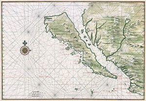
 The unreliability of early maps is highlighted by the manner in which California has been depicted. In the 16th century, the maps of both Mercator and Ortelius correctly show Baja California as a peninsula, but in the following 17th and 18th centuries, it became an island on many charts despite written evidence to the contrary. There is a website dedicated to a study of the ‘island of California’(I), which incongruously ends with a brief reference to Atlantis, placing it in the Atlantic in the Region of Bermuda.
Donald S. Johnson in his well-illustrated Phantom Islands of the Atlantic[0652] discusses in detail the history of seven legendary islands. This fascinating book offers every reason to treat the details of early cartography with extreme caution.
Further difficulties with old cartography are the result of early mapmakers having a dread of blank spaces, a view outlined in a recent (Nov. 2017) National Geographic online article(h).
The most widely referred to map in relation to Atlantis as well as advanced ancient civilisations is the Piri Reis chart. This arguably depicts an ice-free Antarctica and has been used to develop the idea that Atlantis had been located there and was destroyed when a sudden pole shift caused the southern icecap to move to its present position. Rose and Rand Flem-Ath are the leading proponents of this idea based on the findings of Charles Hapgood. Other maps such as that of Phillipe Buache, the renowned French geographer, published in 1737, are claimed to show an ice-free Antarctica.
It is claimed by Ivan Petricevic that The Ben Zara Map of 1487 “displays remnants of glaciers in Britain, but also extremely detailed depictions of islands in the Mediterranean and Aegean seas. Today, these islands still exist, but due to rising water levels, these are now underwater.”(j)
Dale Drinnon had an interesting if speculative, article on ancient maps and their possible relevance to the story of Atlantis(b). Another article in Atlantis Rising magazine (July/August 2014) argues that the quality of medieval navigational charts (portolans) of the Mediterranean exceeded the capabilities of the instruments and knowledge in the region at that time and must have originated elsewhere. However, Roel Nicolai at Holland’s Utrecht University, who expressed these sentiments, was unwilling to nominate Atlantis as the source of the maps(c).
When asked in a recent interview what he meant by ‘advanced civilisation Graham Hancock revealed(u) that “I think we’re talking about a civilization – more than 12,000 years ago – which was as advanced as our civilization was, say in the late 18th century or early 19th century. In other words, they could navigate the world, they could explore the world, they could measure the world accurately, they had precise astronomy, they could create beautiful maps that were accurate in terms of latitude and longitude. That kind of level of civilization.”
Enrique García Barthe is an Argentinian cartographer who has an interesting Spanish/English website(d) dealing with pre-Columbian maps. Although many people have heard of the Piri Reis Map and the controversy surrounding it, García Barthe introduces a lot of new maps that appear to complement Piri Reis.
In 2015, Melissa Brooks used the data in the Atlantipedia chronology of location theories to develop a map(f) showing the distribution and level of support for the various theories on offer.
(a) https://www.thenakedscientists.com/forum/index.php?topic=19800.100
(b) See: Archive 3591
(d) https://web.archive.org/web/20111026020513/https://globalizacion.no.sapo.pt/ingles/pon_ing_1.htm
(e) https://www.bbc.com/future/story/20160614-maps-have-north-at-the-top-but-it-couldve-been-different
(f) https://www.guerrillacartography.org/?s=Atlantis
(h) Why Ancient Mapmakers Were Terrified of Blank Spaces (archive.org) *
(i) https://californiaasanisland.org/
(j) 9 Extremely Ancient Maps That Should Not Exist | Ancient Code (archive.org)
(k) https://www.bbc.com/travel/story/20180819-the-travel-guides-that-charted-our-world
(l) https://www.dailygrail.com/2015/01/ancient-maps-reveal-a-thread-of-truth-weaved-through-antiquity/
(m) https://www.dailygrail.com/2019/04/watch-graham-hancock-discuss-his-new-book-america-before/
