Latest News

Joining The Dots
I have now published my new book, Joining The Dots, which offers a fresh look at the Atlantis mystery. I have addressed the critical questions of when, where and who, using Plato’s own words, tempered with some critical thinking and a modicum of common sense.Read More »
Athanasius Kircher
Nygren, Johan
Johan Nygren is the author of a number of papers touching on a number of subjects, such as expansion tectonics(b), Cro-Magnons and Atlantis. He brings them all together in an Atlantis theory which places Atlantis in the region of Iceland(a). He believes that Cro-Magnon man lived in Atlantis(c). However, in another paper, he claims that Greenland looks like the map of Atlantis created by Athanasius Kircher(e), a suggestion put forward some years ago by Dale Huffman.
When Nygren first wrote about Atlantis, in an article now removed from the internet(d). he was sure that it could be identified as South America,
He also proposes that Atlantis produced the beginnings of civilisation.
(a) https://steemit.com/atlantis/@johan-nygren/iceland-as-atlantis-2-0
(d) Having discovered the myth of Atlantis in the past days, I’ve now conformed to that it described South America (“Isla Atlantica”) — SteemKR (archive.org) (link broken)
Courville, Matthew P.
Matthew P. Courville is the Canadian author of Ancient Navigators [1960] with the bold subtitle of Phoenician Colony of Atlantis. The author is not the first to associate the Phoenicians with Atlantis, but he is certainly the first to offer a reasoned argument, rather than speculation, to justify the suggestion. That is not to say that Courville has completely avoided conjecture.
He suggests that the ‘opposite continent’ referred to by Plato was Africa. Many have proposed America, while I offered Europe, specifically Southern Italy. One important point with which I agree with Courville on, is that the apparent date of 9600 BC, offered by Plato for the time of the Atlantean War is blatantly wrong.
However, we disagree on a number of other issues. Courville arbitrarily decided that the unit of linear measure, the Greek stade, employed by Plato, should have been the ‘plethrum’, but offers little to support this contention. Also unexplained is when Plato does use the plethron are we also to assume that he meant something else? In Critias 116a & 118c the stade and the plethrum appear together but in contexts where, taken at face value, both appear to offer exaggerated dimensions!
I found Courville’s reinterpretation of Athanasius Kircher’s map of Atlantis particularly annoying. Kircher clearly marked Atlantis as situated in the Atlantic Ocean, with Spain and Africa on one side and America on the other. If, as proposed by Courville, Atlantis is Africa, how could it be between itself and America as shown on Kircher’s map? However, my view is that Atlantis was situated in the Mediterranean, where the only two locations unambiguously named as Atlantean were located, namely Southern Italy and North Africa, along with some of the numerous Central Mediterranean islands.
I could continue on a nitpicking expedition, but it would seem pointless if we cannot agree on the basic question of the location of Atlantis. His idea that the Atlanteans were Phoenician must compete with the theories that they were connected with the Sea Peoples or the Hyksos, both of whom were active in the second millennium BC.
The author has obviously put a lot of work into this book, so it is a pity that we have a 400-page work without an index.
Thom, Dieter *
Dieter Thom has published a number of papers on the ResearchGate website, which are mainly concerned with aspects of the Book of Revelation(b). In another of them(a) he claims to have demonstrated that the Azores held the location of Atlantis, using a combination of Google maps and Kircher’s seventeenth-century map.
(a) https://www.researchgate.net/publication/309704475_Atlantis_in_the_Azores_of_the_North_Atlantic
(b) https://pdfcoffee.com/revelation-chronology-pdf-free.html *
Port Arthur *
Port Arthur, is a small town and a former convict settlement in Australia’s Tasmania. It is now nominated as the location of Plato’s Atlantis(a). The promoter of the idea writes in the Above Top Secret website under the pseudonym of ‘bookofthoth’, including a radical re-interpretation of Kircher‘s map of Atlantis. The article also includes a rant about British imperialism and Australia’s gun laws!
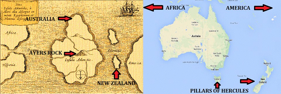
It would be better that the author remains anonymous after the production of such a pathetic, facile explanation of what is a complex document from ancient Greece by one of the pillars of western philosophical thought. Perhaps it was written tongue-in-cheek!
Cartography
Cartography is defined by The International Cartographic Association “as the discipline dealing with the conception, production, dissemination and study of maps.” The earliest land maps can be traced back to Babylonia around 1400 BC. In 2017, Evangelos Livieratos, Professor Emeritus of the Aristotelian University of Thessaloniki Cartography Department, offered evidence that the ancient Greeks were the first to develop a primitive GPS system, using the stars and their relationship with the earth’s surface(g).
The Inuit used unique ‘tactile maps’ as explained on an Italian website(n).
O.A.W. Dilkie (1915-1993) was an English classical scholar and the author of a well-regarded paper Greek and Roman Maps [1753]. The BBC offered an overview of the development of cartography since the 15th century(k).
The subject entered the Atlantis arena in 1665, with the publication of a speculative map(a) of Atlantis, situated in the Atlantic, by Athanasius Kircher. It was allegedly based on earlier Egyptian maps, but unfortunately, there has been no corroborative evidence to support this contention. Kircher’s map had been used to bolster a variety of location theories – Azores, Russia, Baffin Bay and Greenland. Kircher himself favoured the Azores.
Hy-Brasil was reputed to be an island to the west of Ireland and frequently associated with the story of Atlantis. The Genoese cartographer, Angellino de Dalorto (fl.1339), placed Hy-Brasil on a map as early as 1325. It is further claimed that Dalorto, sometimes known as Angelino Dulcert, also depicted Australia on his 1339 portolan chart(l).
However, on some 15th-century maps, the islands of the Azores appear as Isola de Brazil, or Insulla de Brazil. Apparently, it was not until as late as 1865, that Hy-Brasil was finally removed from official naval charts.
Another feature on ancient that can confuse is the placing of the south at the top of old charts, two examples of which are Kircher’s map of Atlantis and Al-Idrisi’s Tabula Rogeriana. Caroline Williams has an interesting article(e) on the BBC website, relating to the history of map orientation.
 The unreliability of early maps is highlighted by the manner in which California has been depicted. In the 16th century, the maps of both Mercator and Ortelius correctly show Baja California as a peninsula, but in the following 17th and 18th centuries, it became an island on many charts, despite written evidence to the contrary. There is a website dedicated to a study of the ‘island of California’(I), which incongruously ends with a brief reference to Atlantis, placing it in the Atlantic, in the Region of Bermuda.
Donald S. Johnson in his well-illustrated Phantom Islands of the Atlantic[0652] discusses in detail, the history of seven legendary islands. This fascinating book offers every reason to treat the details of early cartography with extreme caution.
Further difficulties with old cartography are the result of early mapmakers having a dread of blank spaces, a view outlined in a recent (Nov. 2017) National Geographic online article(h).
The most widely referred to map in relation to Atlantis, as well as advanced ancient civilisations is the Piri Reis chart. This arguably depicts an ice-free Antarctica and has been used to develop the idea that Atlantis had been located there and was destroyed when a sudden pole shift caused the southern icecap to move to its present position. Rose and Rand Flem-Ath are the leading proponents of this idea, based on the findings of Charles Hapgood. Other maps such as that of Phillipe Buache, the renowned French geographer, published in 1737, are also claimed to show an ice-free Antarctica.
It is claimed by Ivan Petricevic that The Ben Zara Map of 1487 “displays remnants of glaciers in Britain, but also extremely detailed depictions of islands in the Mediterranean and Aegean seas. Today, these islands still exist, but due to rising water levels, these are now underwater.”(j)
Dale Drinnon had an interesting if speculative, article on ancient maps and their possible relevance to the story of Atlantis(b). Another article in Atlantis Rising magazine (July/August 2014) argues that the quality of medieval navigational charts (portolans) of the Mediterranean, exceeded the capabilities of the instruments and knowledge in the region at that time and must have originated elsewhere. However, Roel Nicolai at Holland’s Utrecht University, who expressed these sentiments, was unwilling to nominate Atlantis as the source of the maps(c).
When asked in a recent interview what he meant by ‘advanced civilisation Graham Hancock revealed(u) that “I think we’re talking about a civilization – more than 12,000 years ago – which was as advanced as our civilization was, say in the late 18th century or early 19th century. In other words, they could navigate the world, they could explore the world, they could measure the world accurately, they had precise astronomy, they could create beautiful maps that were accurate in terms of latitude and longitude. That kind of level of civilization.”
Enrique García Barthe is an Argentinian cartographer, who has an interesting Spanish/English website(d) dealing with pre-Columbian maps. Although many people have heard of the Piri Reis Map and the controversy surrounding it, García Barthe introduces a lot of new maps, that appear to complement Piri Reis.
In 2015, Melissa Brooks used the data in the Atlantipedia chronology of location theories to develop a map(f) showing the distribution and level of support for the various theories on offer.
(a) https://www.thenakedscientists.com/forum/index.php?topic=19800.100
(b) See: Archive 3591
(d) https://web.archive.org/web/20111026020513/https://globalizacion.no.sapo.pt/ingles/pon_ing_1.htm
(e) (BBC June15, 2016) https://www.bbc.com/future/story/20160614-maps-have-north-at-the-top-but-it-couldve-been-different
(f) https://www.guerrillacartography.org/?s=Atlantis
(g) https://www.tornosnews.gr/en/greek-news/culture/22876-cartography-professor-ancient-greeks-in-ionia-first-used-gps-method-to-navigate.html
(h) Why Ancient Mapmakers Were Terrified of Blank Spaces (archive.org)
(i) https://californiaasanisland.org/
(j) 9 Extremely Ancient Maps That Should Not Exist | Ancient Code (archive.org)
(k) (BBC Aug 20, 2018) https://www.bbc.com/travel/story/20180819-the-travel-guides-that-charted-our-world
(l) https://www.dailygrail.com/2015/01/ancient-maps-reveal-a-thread-of-truth-weaved-through-antiquity/
(m) https://www.dailygrail.com/2019/04/watch-graham-hancock-discuss-his-new-book-america-before/
(n) Tactile maps of Greenland and bowen’s map – The Tapestry of Time (larazzodeltempo.it)
Godwin, Joscelyn
Joscelyn Godwin (1945- ) was born in England and is currently professor of  musicology at Colgate University in Hamilton, New York. Although he has written on his chosen subject, he has also ventured into the realms of Theosophy, the Mystery Traditions and the esoteric generally. Included in his output is a life of Athanius Kircher[1130]. In 2009, this book was revamped as Athanasius Kircher’s Theatre Of The World, which has been described as “essentially a big-budget version of the previous book.” [1593]*
In his 1996 book Arktos[789] he traces the history of polar wandering theories together with the polar connection with some Nazi ideology. His latest offering, Atlantis and the Cycles of Time[746] is a very comprehensive history of occult view of the Atlantis mystery.
A brief biography of Godwin, together with his impressive bibliography, is available on the Colgate University website(a).
le Plongeon, Augustus
Augustus le Plongeon (1826-1909) was born on Jersey in the Channel  Islands. He was a professional photographer and amateur archaeologist, who was an enthusiastic follower of Ignatius Donnelly’s idea that the alphabets of the Old and New Worlds were derived from a common Phoenician root via Atlantis. He also attempted to build on the efforts of Diego deLanda and Brasseur de Bourbourg to decipher the Mayan hieroglyphics. Both Donnelly’s efforts to link Latin with Mayan glyphs and deLanda’s attempt to identify the Mayan alphabet bore little fruit, reminiscent of Kircher’s equally futile struggle with Egyptian hieroglyphics.
Le Plongeon, with comparable wasted dedication, attempted to convince the world that the Mayan language was in fact Greek. It would have been easier to prove that chalk is cheese. His attachment to the Mayan civilisation also inspired him to claim that they were the founders of the culture of Ancient Egypt via a trip westward through Asia and on to the Mediterranean. When it was eventually demonstrated that the Mayan culture was considerably younger than that of ancient Egypt, le Plongeon refused to relinquish his absurd ideas and continued to claim that the Maya were the oldest people on the planet(e).
Le Plongeon was alone in suggesting that Atlantis was a colony of the Maya.
He was also the creator of numerous other bizarre notions regarding such matters as Mu[439] and the last words of Christ. Incidentally, like Abbe Charles Etienne Brasseur de Bourbourg, Le Plongeon equated Mu with Plato’s Atlantis(e). He was convinced that the Mayan inscriptions on the pyramid of Xochicalco told the story of the destruction of Atlantis.It is remarkable that the author of such outlandish notions is quoted so frequently today, since few accept that he has contributed much to the advancement of knowledge. Jörg Dendl offers an extensive critique, in German, of Le Plongeon’s views(c) and worth a read.
Robert Schoch has suggested(a) that Le Plongeon, himself a freemason, had another agenda, namely, to establish links between freemasonry and the ancient Maya. A potted biography of Le Plongeon on the Internet(b) is also to be recommended.
Le Plongeon’s Vestiges of the Maya is available online(d).
(a) https://web.archive.org/web/20050530100238/https://www.robertschoch.net/articles/westernsphinx.pdf
(c) https://www.dendlon.de/Atlantis.html
(d) https://www.gutenberg.org/files/30752/30752-h/30752-h.htm
Kircher, Athanasius
 Fr. Athanasius Kircher (1602-1680) was a German Jesuit scholar and a professor of ethics and mathematics at the University of Würzburg. In his day, he was considered one of the greatest authorities in Europe on Chinese and Egyptian cultures, archaeology, ancient languages and astronomy. However, he was not without his detractors, one of whom was Descartes, who robustly attacked Kircher’s scientific abilities. Kircher’s writings filled 44 folio volumes.
Kircher claimed to have deciphered the ancient Egyptian hieroglyphics, but this was later shown to be unfounded and drew highly critical comments such as that of the Egyptologist Sir E. A. Wallis Budge who wrote in 1910: Many writers pretended to have found the key to the hieroglyphics, and many more professed, with a shameless impudence which is hard to understand in these days, to translate the contents of the texts into a modern tongue. Foremost among such pretenders must be mentioned Athanasius Kircher, who, in the 17th century, declared that he had found the key to the hieroglyphic inscriptions; the translations which he prints in his Oedipus Aegyptiacus are utter nonsense, but as they were put forth in a learned tongue many people at the time believed they were correct. A more recent critique is available online(b).
When it is realised that more than a century was to pass after Kircher’s death before the Rosetta Stone was discovered and the work of Champollion finally gave us a reliable decipherment of Egyptian hieroglyphics, it is quite reasonable to treat Kircher’s translation as purely speculative. His efforts in this regard were recently described as ‘illusory’.
In recent times, Kircher has regained widespread fame because of the map, published in his Mundus  Subterraneus [1203], which, among a range of subjects(c), outlines Atlantis (Insula Atlantis) between Africa and America. This Latin text can now be read or downloaded online(a). A 1678 edition of the book held in the Fagel Collection in Trinity College, Dublin, has been described as one of the most beautiful books in the collection(h).
In Mundus Subterraneus, Kircher was the first to propose that the Canaries and the Azores were the mountain peaks of sunken Atlantis. His famous map has the north shown at the bottom with Africa and Spain on the left and America on the right. There is no particular significance in this fact, as the convention of having North at the top of maps is relatively recent and generally attributed to the controversial 8th-century Irish cleric, Virgil of Salzburg, who was eventually appointed bishop of that city and later canonised as St. Virgilius. A Latin label on the map reads: “site of Atlantis, now beneath the sea, according to the beliefs of the Egyptians and the description of Plato. A chart based on beliefs and descriptions clearly shows that his offering is speculative and not a real map, although some claim that it is an ‘authentic’ depiction of Atlantis, such as can be seen on an hour-long YouTube video from a 1997 conference(g).
Despite being based on speculation, Kircher’s map is still widely used today. An article by Phil Edwards has commented on its continued use – ” We can only guess why one map became the iconic depiction of Atlantis, but there are a few reasonable assumptions. It had a veneer of scientific legitimacy, thanks to Kircher’s reputation and other work. It came at a time when the world was actively being reimagined. And Kircher’s map was one of the earliest ones nestled into an otherwise accurate depiction of the world. And perhaps most important is that once Atlantis’s appearance was established it couldn’t really be disproven. So the same map stuck around for centuries” (l).
Recently, Doug Fisher>>and Johan Nygren(m) have<<drawn attention to the similarities between a 1592 map of South America by Abraham Ortelius and Kircher’s Atlantis map when inverted(e). Frank Jacobs has highlighted the same comparison but also notes how the map might be seen as an image of Greenland(i). Some further background information on Kircher’s map is to be found online(f).
Kircher’s Atlantis map is widely used, particularly by supporters of an Atlantic Atlantis. Some, such as Dieter Thom, have followed Kircher’s view that Atlantis had been located in the Azores, while others have been more liberal in their interpretation of the map. Dale Huffman, Johan Nygren and Mario Dantas have associated the map with Greenland. Ian A. Fox has pushed matters further by nominating Baffin Bay west of Greenland as formerly the Plain of Atlantis. Now, while all these have kept their chosen Atlantis locations within the Atlantic Ocean, conforming, at least to some extent, with Kircher’s map. However, there are a number of commentators who have employed the map to justify even more exotic locations. At one end of the world, Rand and Rose Flem-Ath were apparently, inspired by Kircher’s map and opted for an Antarctic Atlantis, while at the other end, just south of the Arctic Circle, Marco Francesco Bulloni has nominated the Solovetsky archipelago in northwest Russia as the home of Atlantis, once again inspired by Kircher. Of course, I’ve saved the best for last with Australia as the nominee and a specific location of Port Arthur in Tasmania(k).
Less known is his 1665 world map recently published on the atlan.org. website(j).
![]() In 2004 a book[425] with the enticing title of Athanasius Kircher: The Last Man Who Knew Everything was published. It was edited by Paula Findlen and includes essays by leading historians of our day.
In 2004 a book[425] with the enticing title of Athanasius Kircher: The Last Man Who Knew Everything was published. It was edited by Paula Findlen and includes essays by leading historians of our day.
(a) https://archive.org/details/mundussubterrane02kirc
(b) https://publicdomainreview.org/2013/05/16/athanasius-kircher-and-the-hieroglyphic-sphinx/
(c) https://publicdomainreview.org/2012/11/01/athanasius-underground/
(e) https://atlantismaps.com/chapter_7.html (Link broken Nov. 2018) New replacement site is now being developed – https://www.copheetheory.com/
(f) https://www.vox.com/2015/4/30/8516829/imaginary-island-atlantis-map-kircher
(g) https://www.youtube.com/watch?v=DZcuJKilUdw
(h) The Fagel Collection (archive.org)
(i) Could South America be Atlantis? – Big Think
(k) The location of Atlantis, page 1 (archive.org) (The map was not saved by Wayback Machine)
(l) https://www.vox.com/2015/4/30/8516829/imaginary-island-atlantis-map-kircher
Cro-Magnon Man
Cro–Magnon Man emerged around 37,000 years ago and disappeared at the end of the Last Ice Age. He is often described as having a dome-shaped cranium and broad forehead and a brain capacity of 1,600 cc, which is greater than modern man. His skull has thick eyebrow projections and a bony protrusion at the back, that is characteristic of both Neanderthal man and Homo erectus. Blavatsky(c), Sepehr(d) along with a number of investigators(e)(n)* have suggested that they may have been the original Atlanteans. They have pointed to the physical traits listed above, together with blood grouping and linguistic similarities to be found in the same regions of Western Europe and North Africa.
Robert John Langdon also claims that “Cro-Magnon/Atlanteans colonised America” based on a study of blood group distribution(b). R. Cedric Leonard is another supporter of the idea of Cro-Magnons in America(h), citing the work of Dennis Stanford & the late Bruce Bradley [1516]. Leonard offered a more complex view of Cro-Magnons on his now-closed website, but excerpts are available elsewhere(j).
Physical anthropology has identified the modern remnants of Cro-Magnon Man in the Berbers and Tuaregs of North Africa, the Basques of Northern Spain, together with small population pockets in the Dordogne Valley and Brittany in France. The highest incidence of Rhesus-negative blood in the world is to be found among the Basques. Similar high levels of Rhesus-negative blood are to be found among the inhabitants of the Canaries and the Atlas Mountains of Morocco; areas where Cro-Magnons lived. This fact is seen as evidence for claiming that the Basques are directly descended from Cro-Magnon Man.
On the basis of skull shape, William Howells[268] and Bertil Lundman[269] have supported this view. The regions that were home to Cro-Magnon Man, in Upper Palaeolithic times, were comparable with those occupied by their latter-day successors, such as the now-extinct Guanches of the Canaries and the Basques.
R. Cedric Leonard is probably the best-known modern proponent of the Atlantean Cro-Magnon idea(f), he refers to the work of Oliviera Martins[270], who in the 1930s, pointed out that many of the Cro-Magnon people have given themselves distinguishing names with the suffix ’tani’ from the Mauritani of North Africa, to the Bretani of Brittany and Britain. Leonard also insists that an analysis of the languages of these groups of people points to a relationship with each other, while being quite different from the other languages of Europe or the Near East. He thinks that it is quite possible that these ancient languages date back to the cultures of the Ice Age. Leonard also refers to what he calls “an anomalous Cro-Magnon/Atlantis outpost” in northern Palestine(a).
Alexander Marshack (1918-2004) was an American journalist turned archaeologist, who, in the 1970s, offered evidence[1633] that markings on a number of bones from the Upper Palaeolithic were used as lunar calendars to mark the passage of time. Similar markings have been identified on the painted walls of the famous Cro-Magnon Lascaux caves in France(g).
At the Palaeolithic site at Little Salt Spring in Florida an antler incised with 28 notches was reported in 2011(i). Commenting on this, Caleb Everett has proposed [1776.30] that “In fact, the marks suggest that this piece of antler is the oldest known New World artifact used for calendrical purposes.” If confirmed, it will go some way towards vindicating the much-criticised theories of Marshack!
This combination of date, geographical spread, language and physical similarities offers a reasonable basis for postulating the idea of a coherent civilisation along the European and North African Atlantic seaboards and in the Atlantic itself, at the end of the last Ice Age, that could be accommodated by one interpretation of Plato’s Atlantis. Lewis Spence was a supporter of this possibility.
Jason Colavito has unearthed late 19th-century attempts to link the Cro-Magnons with the Nephilim of the Bible(k).
Johan Nygren believes that Cro-Magnon man lived in Atlantis(c), which he claims had existed in the vicinity of Iceland(l). He also drew attention to the similarities between Greenland and the 17th-century map of Atlantis, offered by Athanasius Kircher(m).
The possibility of a Cro-Magnon connection with Atlantis has inspired an American writer, Ernest Warner, to produce a number of novels based on this concept, starting with The Cro-Magnon Archipelago: Atlantis Reborn, in 2021.
(a) http://web.archive.org/web/20200215020959/http://atlantipedia.ie/samples/archive-2260/
(b) The Post Glacial Flooding Hypothesis: Cro-Magnon/Atlanteans colonised America (archive.org)
(c) Cro Magnon Man And Atlantis – blavatsky.net (archive.org)
(d) https://atlanteangardens.blogspot.ie/2014/04/the-cro-magnon-invasions.html
(e) https://differentpast.wordpress.com/2012/05/19/cro-magnon-and-atlantis/
(f) https://atlantisforschung.de/index.php?title=Atlantis_und_der_Cro-Magnon-Mensch
(g) (BBC Oct 16, 2000) https://news.bbc.co.uk/2/hi/science/nature/975360.stm
(h) https://web.archive.org/web/20161126063206/https://www.atlantisquest.com/America.html
(i) Budget Cuts Close Florida’s Little Salt Spring – Archaeology Magazine (Feb 4, 2013)
(j) new illuminati: Atlantis and Cro-Magnon Man (nexusilluminati.blogspot.com)
(k) An Early Argument that Cro-Magnons Were the Nephilim – JASON COLAVITO
(l) https://steemit.com/atlantis/@johan-nygren/iceland-as-atlantis-2-0
(n) Atlantis Rising #29 p.30
Azores
The Azores (Açores) is a group of Portuguese islands in the Atlantic, situated 1,500 km from the mainland. The first recorded instance of their discovery is in 1427 by the Portuguese, although there is some evidence to suggest that the Norse reached the islands 700 years earlier(z). However, they were not the first, as recent discoveries have shown clearly that megalith builders and others had occupied the archipelago’s island of Terceira long enough to construct several megalithic monuments(aa). Professor Felix Rodrigues has claimed that these structures were stylistically related to European megaliths. The island also has a number of cart ruts, a subject about which Rodrigues et al have published a paper(ad). The significance of the megaliths on Terceira is far greater than might be first thought. Received wisdom has it that apart from coastal hugging, ocean-going vessels were not available until the time of the Phoenicians. The Azorean megaliths suggest otherwise. Furthermore, it throws new light on the possibility of Neolithic and/or Bronze Age visits to America from the Old World. A BBC video(ab) has some interesting images, while for Portuguese speakers, a RTP video(ac) has an interview with Professor Rodrigues, who has also written a paper on early Atlantic navigation(ae).
The earliest association of the Azores with Atlantis dates from 1499, when Maximillian I of the Holy Roman Empire (1459-1519) appointed Lukas Fugger vom Reh as the ‘titular’ king of Atlantis. The certificate of appointment nominated the Azores as the remnants of Atlantis. Markus Fugger, a descendant of Lukas, has published a 2013 paper defending this identification of the Azores with Atlantis(x).
In 2012, the president of the Portuguese Association of Archeological Research (APIA), Nuno Ribeiro, revealed(c) that rock art had been found on the island of Terceira, supporting his belief that human occupation of the Azores predates the arrival of the Portuguese by many thousands of years. A further article(a) in October 2016 expanded on this matter. Ribeiro’s research was trotted out in a more recent documentary from Amazon Prime with the tabloid title of New Atlantis Documentary – Proof that Left Historians Speechless(u), which explores the claim that the Azores are the mountain tops of sunken Atlantis!
However, the Portuguese authorities set up a commission to look into Ribeiro’s contentions and concluded(q) that any perceived remnants of an ancient civilization were either natural rock formations or structures of more modern origin. Nevertheless, as the Epoch Times reports(r) that “Antonieta Costa, a post-doctoral student at the University of Porto in Portugal, remained unconvinced and continued research into the hypothesis that the Azores were inhabited in antiquity and even in prehistory.” In 2013, Costa, published, in English, The Mound of Stones [1967] about the megaliths of the Azores.
It seems to me that the research of Rodrigues, Ribeiro and Costa should be looked at again as a combined study so that the ancient history of the Azores can be more clearly understood and its mysteries resolved.
It is thought that the Phoenicians and Etruscans competed for control of the Azores in later years. In 2011, APIA archaeologists reported that they had discovered on Terceira island a significant number of fourth-century BC Carthaginian temples. They believe the temples were dedicated to the ancient Phoenician/Carthaginian goddess Tanit(c).
The Jesuit, Athanasius Kircher, in his 1665 book Mundus Subterraneus, was the first to propose that these islands were the mountain peaks of sunken Atlantis. This view was adopted by Ignatius Donnelly and developed by successive writers and is still supported by many today. Kakhi Margiani, a Georgian researcher, has also identified the Azores as the source of the Atlantis myth.The latest recruit is Carl Martin, who is currently working on a book locating Atlantis in the Azores and destroyed around 9620 BC. The late Christian O’Brien was a long-time proponent of the Atlantis in Azores theory. A bathymetric study of the area suggested to O’Brien that the archipelago had been a mid-Atlantic island 480 x 720 km before the end of the last Ice Age. Apart from the inundation caused by the melting of the glaciers, he found evidence that seismic activity caused the southern part of this island to sink to a greater degree than the north. O’Brien pointed out that six areas of hot spring fields (associated with volcanic disturbances) are known in the mid-Atlantic ridge area, and four of them lie in the Kane-Atlantis area close to the Azores.
Klaus Aschenbrenner was originally happy to consider the Azores as a possible location for Atlantis, but further research led him to conclude that this was unlikely(ag).
In 1982 Peter Warlow suggested [135] that a sea-level drop of 200 metres would have created an island as large as England and Wales with the present islands of the Azores as its mountains. However, Rodney Castleden contradicts that idea[225.187] saying that if the sea level was lowered by 200m “the Azores would remain separate islands.” Bathymetric maps of the archipelago, above and on the Internet(g), verify Castleden’s contention. This together with a 1982 paper from P.J.C. Ryall et al, demonstrates more clearly that the Azores are just the summits of volcanic seamounts that rise from an underwater plateau that is 1000 metres below sea level. Professor Ryall and his associates were dealing objectively with the geology of the area and were not promoting any view regarding Atlantis. The geological evidence supporting an Azorean Atlantis is therefore very weak, verging on non-existent.
Andrew Collins, the leading proponent of a Cuban Atlantis, has written a short review of the Azorean Hypothesis(h).
Frank Joseph has offered his views on Atlantis in the Azores in a YouTube video(l).
Nikolai Zhirov recounts in his book[458.363] how Réne Malaise wrote to him regarding a Danish engineer named Frandsen who identified a plateau, 2/3rds the size of Finland, south of the Azores, whose summits were 4,000-5,000m metres higher than it. Adding canals gave Frandsen a configuration that closely matched Plato’s description of Atlantis. Zhirov also noted[p403] that in 1957 a journal entitled Atlantida was published in the Azores.
In 1976, Jürgen Spanuth pointed out[015.249] that the Azores are not the mountain peaks of a sunken continent but are instead volcanic rock created through an eruption. He quotes similar sentiments expressed by Hans Pettersson. A 2003 paper(b) by four French scientists demonstrated that the Azores had been greatly enlarged during the last Ice Age. However, showing that the Azores were more extensive is not disputed, but it in no way demonstrates that it was the location of Atlantis. In fact, Plato’s description of the magnificent mountains to the north and the mud shoals that were still a hazard in Plato’s day do not match the Azores. The geologist, Darby South, strongly denied that the Azores could have been the location of Atlantis, according to a couple of articles posted on the internet some years ago(a). However, natives of the archipelago are quite happy to assert a link with Atlantis, as travel writer David Yeadon found on a visit there(d).
Nevertheless, advocates of Atlantis in the Azores must accept that when the Portuguese arrived on the island in the 15th-century they were found to be uninhabited and without any evidence of an earlier advanced civilisation there, such as described by Plato. Initially, the only hint of earlier visitors was some 3rd-century BC coins from Carthage discovered on the island of Corvo. However, in recent years, Bronze Age rock art(f) and what is described as a Carthaginian temple(e) have both been discovered on the island of Terceira.
Otto Muck among others was certain that the enlarged Azores had deflected the Gulf Stream during the Ice Age, contributing to the extent of the Western European glaciation. However, a 2016 report(m) from the Center for Arctic Gas Hydrate, Climate and Environment (CAGE) offered evidence that the Gulf Stream was not interrupted during the last Ice Age, which would seem to undermine one of Muck’s principal claims.
Nevertheless, it is still far from clear what caused the end of the last Ice Age. Several writers, including Muck, speculated that an asteroidal impact in the Atlantic was responsible. When the Azores were discovered in the 15th century they were uninhabited and without any evidence of an earlier civilisation. It can be reasonably argued that since the Azores today are just the mountain peaks of a larger, mainly submerged island, any remains would be more likely to be found on the plains and estuaries that are now underwater.
One undeveloped theory is that the name ‘Azores’ might be linked to the ninth king of Atlantis, Azaes, listed by Plato. This idea is supported by the linguist Dr Vamos-Toth Bator. However, a Portuguese correspondent has pointed out that the Azores are named after a goshawk (Accipiter gentilis) commonly found on the islands and portrayed on the regional flag. The renowned writer, Dennis Wheatley, used the possibility of Atlantis being located in the Azores as a backdrop to his 1936 thriller, They Found Atlantis.
In August 2013 Portuguese American Journal reported that the many pyramidal structures on Pico are clear evidence of extensive human activity in the archipelago, long before the arrival of the Portuguese(o). A YouTube video(p) offers some interesting views of the pyramids. If these pyramid builders were capable of sailing from mainland Europe as far as the Azores, understandably, it has prompted some to question whether the same people were able to complete the journey to the Americas! In 2014, Dominique Görlitz gave a lecture on the pyramids(ai) and the Atlantisforschung website has an article on the debate between Nuno Ribeiro and Portuguese archaeologists, regarding the authenticity of the pyramids(aj).
The following month, the same journal announced the discovery of a pyramidal structure 60 metres high at a depth of 40 metres, off the coast of the Azorean island of Terceira(i). Shortly afterwards, the Portuguese Navy denied the existence of any such structure(j). Not exactly a surprise! Nevertheless, an Italian website has attempted to breathe new life into the story by linking this underwater pyramid report with pyramidal structures found on the island of Pico(k).
Atlantisforschung published an article that included critical comments about the ‘pyramid’ from both Greg Little and Andrew Collins.“A Portuguese Navy commander states that there is a read error of the sonar data and that the alleged pyramid was a volcanic mound. Afterwards, the Portuguese Hydrographic Institute [also] stated that the “ Pyramid ” was a known volcanic mound and posted actual underwater bottom contours of the site obtained from a hydrographic survey.
For the Portuguese Navy and its officials (who were originally said to be excited and involved), that was the end of the matter. But allegations arose almost immediately that this was a cover-up. Apparently, there was a Pyramid of Atlantis there, some claimed, and for obscure reasons, the government didn’t want anyone to know about it. At least that’s what is claimed. But of course, none of the people claiming a cover-up will ever go there and dive or lower a camera themselves. It’s probably [from their point of view; much better to keep it alive as a mystery. At the end of the day, no one wants to admit the truth — or know the truth.”(z).
The Wikiversity website has an extensive article(s) on the location of Atlantis, which is focused on the Azores and the bathymetric evidence for that archipelago having been a large single landmass at the end of the last Ice Age, when sea levels were much lower. However, it is based on the literal acceptance of Plato’s 9,000 years before Solon for the date of the Atlantean War.
April 2018 saw British tabloid interest in Atlantis revived with further speculation on the Azores as the location of Plato’s submerged island(t). However, the details of the claim were rejected by Dr Richard Waller, a lecturer at Keele University. Not content with recycling the old Azores theory, The Star also throws in the even more nonsensical idea of an Antarctic Atlantis.
A paper by Gerard Janssen of Leiden University places Homer’s Ogygia in the Azores(v).
In 2019, Fehmi Krasniqi published a three-and-a-half-hour video on the building of the Egyptian pyramids. For Krasniqi, the Ancient Black Egyptians travelled to the Americas and many other parts of the world(af). He claims that these ancient Egyptians travelled to America using Atlantis, now the Azores as a stepping-stone. This is offered as an explanation for the huge Olmec stone heads with African features!
A recent (2021) advocate of Atlantis in the region of the Azores is Victor Staner(w). In the same year, I was made aware of the work of Matthew Chinn, who also pinpointed a location (38° 32′ 06″ N, 29° 24′ 09″ W) in the Azores region as the site of Atlantis, using satellite imagery and bathymetric data. Chinn’s claim has been strongly endorsed by Keith M. Hunter(ak).
Support for the Azores continued with a book from Michael le Flem, Visions of Atlantis [1958] in 2022, an excerpt from which was published on the Ancient Origins website in January 2023(ah).
David Lee Fernandes has published a number of papers relating to the story of Atlantis. A 2025 document explores the similarities betwwen the Azores and Plato’s description of Atlantis(al).
My leading questions regarding the proposed Azorean location for Atlantis are (a) why and (b) how would Atlanteans situated in the middle of the Atlantic launch an attack on Athens or Egypt that were over 4,200 km away? Unless those two questions are satisfactorily answered, the Azores fails as the home of Atlantis.
(g) https://www.internalwaveatlas.com/Atlas2_PDF/IWAtlas2_Pg049_Azores.pdf
(h) https://www.andrewcollins.com/page/interactive/midatlan.htm
(i) https://portuguese-american-journal.com/terceira-subaquatic-pyramidal-shaped-structure-found-azores/
(j) https://www.unexplained-mysteries.com/forum/index.php?showtopic=255178&st=75
(k) https://www.stampalibera.com/?a=28020#sthash.EUkbmusn.dpuf (Site now offline)
(l) https://www.youtube.com/watch?v=fRABMVIV0pQ
(m) https://www.sciencedaily.com/releases/2016/02/160219134816.htm
(p) https://www.youtube.com/watch?v=wmd89nPH4WM
(q) https://www.scribd.com/document/327357287/Relatorio-Comissao (Portuguese)
(v) http://homerusodyssee.nl/id27.htm
(w) Atlantis | Captainvic (wixsite.com)
(z) Viking mice: Norse discovered Azores 700 years before Portuguese | CALS (cornell.edu)
(aa) Megalithic Constructions Discovered in the Azores, Portugal (scirp.org)
(ab) (BBC Oct 26, 2022) Was the Azores home to an ancient civilisation? (bbc.com)
(ac) https://www.youtube.com/watch?v=hBPyCYo97VQ (Port)
(ad) (99+) Dating the Cart-Ruts of Terceira Island, Azores, Portugal | Félix Rodrigues – Academia.edu
(af) Solving The Mystery Behind the Building of the Great Pyramid – Rising Tide Foundation
(ag) Was Atlantis in the Azores? – Klaus-Aschenbrenner (archive.org)
(ah) https://www.ancient-origins.net/ancient-places-europe/azores-atlantis-0017844
(ai) The pyramids on the Azores – lecutre by keynote speaker Dr. Görlitz (archive.org) (Unavailable)
(ak) https://www.lostagesecrets.com/the-lost-city-of-Atlantis.html
(al) https://www.academia.edu/128268348/Atlantis_Submerged_settlements_of_the_Azores_Archipelago_Revised_