Latest News

Joining The Dots
I have now published my new book, Joining The Dots, which offers a fresh look at the Atlantis mystery. I have addressed the critical questions of when, where and who, using Plato’s own words, tempered with some critical thinking and a modicum of common sense.Read More »
Hi-Brasil
Hi-Brasil or Hy-Brasil
Hi–Brasil or Hy–Brasil is sometimes referred to as the Irish Atlantis and is a name given to a legendary island to the west of Ireland. It is frequently referred to as the Fortunate Island, which has obvious resonances with the Hesperides. Another appellation in Irish is Tir fo-Thuin or Land under the Wave. A further explanation offered for the origin of the name is that it is derived from an ancient term ‘brazil’ that refers to the source of a rare dye, which is reminiscent of the expensive purple dye extracted from the Murex snail, traded by the Phoenicians.
One theory is that in the dim and distant past a part of what is now known as the Porcupine Bank, just west of Ireland, was exposed when the sea levels were lower as a result of the last Ice Age. When the feature was submerged by the rising seas it was probably eroded further by the ocean currents. The claim is that a memory of the exposed land lingered in the folk memory of the inhabitants of the west coast of Ireland.
Marin, Minella & Schievenin in The Three Ages of Atlantis [972.375] propose that the island of Thule described by Pytheas was the legendary Hi-Brasil, which, they further claim, was part of the Porcupine Bank that they describe as ‘recently submerged’.
The Genoese cartographer, Angellino de Dalorto (fl.1339), placed Hy-Brasil west of Ireland on a map as early as 1325. However, on some 15th-century maps, the islands of the Azores appear as Isola de Brazil, or Insulla de Brazil. Apparently, it was not until as late as 1865 that Hy-Brasil was finally removed from official naval charts. Also found on medieval maps was another mystery island south of Brasil, sometimes appearing as Mayda, Asmaidas or Brazir(d).
Phantom islands have been shown on maps for hundreds of years and some as recently as the 20th century(f).

Mercator’s Brasil
One of the most famous visits to Hy-Brasil was in 1674 by Captain John Nisbet of Killybegs, Co. Donegal, Ireland. He and his crew were in familiar waters west of Ireland, when a fog came up. As the fog lifted, the ship was dangerously close to rocks. While getting their bearings, the ship anchored in three fathoms of water, and four crew members rowed ashore to visit Hy-Brasil. They spent a day on the island and returned with silver and gold were given to them by an old man who lived there. Upon the return of the crew to Ireland, a second ship set out under the command of Alexander Johnson. They, too, found the hospitable island of Hy-Brasil and returned to Ireland to confirm the tales of Captain Nisbet and crew.
The last documented sighting of Hy-Brasil was in 1872 when author T. J. Westropp and several companions saw the island appear and then vanish. This was Westropp’s third view of Hy-Brasil, but on this voyage, he had brought his mother and some friends to verify its existence.
The Irish historian, W.G.Wood-Martin, also wrote[388.1.212] about Hi-Brazil over a hundred years ago.
Donald S. Johnson has also written an illustrated and more extensive account of the ‘history’ of Hi-Brazil in chapter six of his Phantom Islands of the Atlantic [652].
A modern twist on the story arose in connection with the Rendelsham UFO(b) mystery/hoax(c) of 1980, when coordinates that correspond to one of the Hy-Brasil locations were allegedly conveyed to one Sgt. Jim Penniston who kept it secret for thirty years(a)!
In 2010, the September 11th edition of the London Daily Mail (and its sister paper, the Irish Daily Mail) ran an article with the adventurous headline “The Atlantis of Connemara” that included the accounts of 20th-century witnesses to unexplained visions off the west coast of Galway. Included was a potted history of recorded sightings since 1460.
In 2013 Barbara Freitag published a valuable in-depth study[1331] of Hy-Brasil dealing with its cartography, history and mythology.
(b) The Rendlesham Forest UFO case – Ian Ridpath (archive.org)
(c) (BBC June 30, 2003) https://www.bbc.co.uk/insideout/east/series3/rendlesham_ufos.shtml
(d) https://en.wikipedia.org/wiki/Mayda
(e) http://web.archive.org/web/20220118093816/https://atlantipedia.ie/samples/archive-2272/
(f) https://en.protothema.gr/a-list-of-various-phantom-islands-recorded-throughout-history/
Ortelius, Abraham
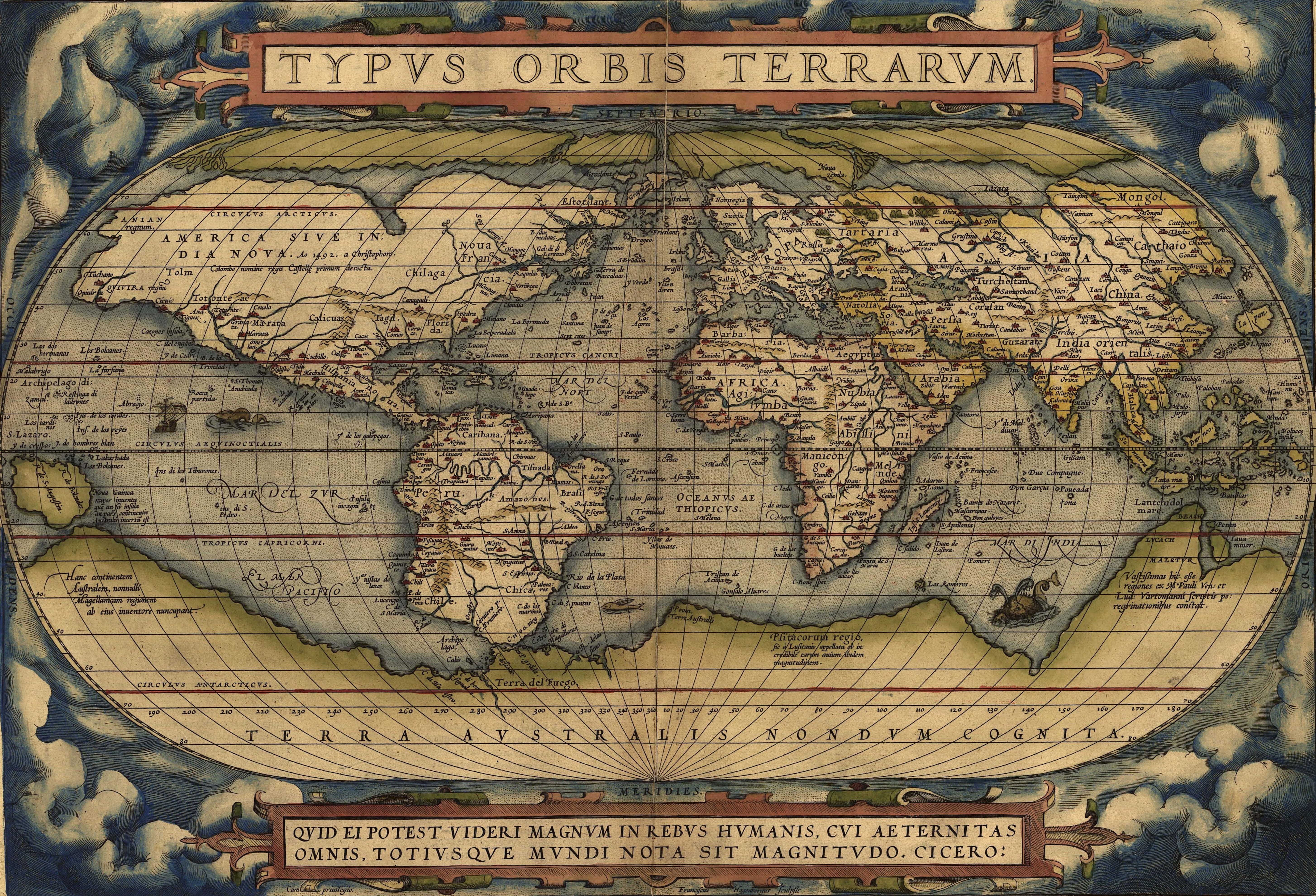
 Abraham Ortelius (1527-1598) was a Flemish cartographer who produced the first modern atlas, Theatrum Orbis Terrarum[1226], which at the time was reputed to have been the most expensive book ever printed.
It is interesting that he included the mythical island of Hi-Brasil (Brasil) off the coast of Ireland as well as the equally mysterious Frisland (Frieslant). Both can be clearly seen on his map using the link below(a).
In 1596, Ortelius was struck by the possibility that America, Europe and Africa had at one time been joined together but had over time become separated, an idea expressed in his Thesaurus Geographicus[1225]. Ortelius also included a speculative southern landmass, Terra Australis, which he designated as a “land of parrots”.
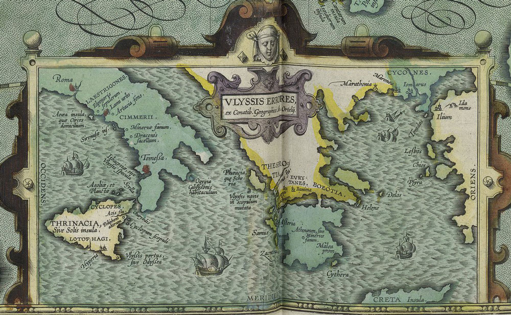
In 1597, Ortelius was the first to map(d) the travels of Homer’s Odysseus, notably locating all his adventures in the Central and Eastern Mediterranean, which was probably just a reflection of the limits of Greek maritime knowledge at the time that the narrative originated!
Ortelius suggested that Atlantis had been located in North America but it had separated in the very distant past! Before modern theories of Continental Drift and its successor, Plate Tectonics, the idea of landbridges between continents was popular as an explanation for the spread of animals and people around the world. Some suggested as an alternative, the existence of lost continents such as Atlantis in the Atlantic, which acted as a stepping-stone between the continents(c).
Four hundred years later, Alfred Wegener incorporated some of Ortelius’ ideas into his theory of Continental Drift, which later led to the current theory of Plate Tectonics.
A purpose-built polar exploration ship, m.v. Ortelius, was named after the geographer.
Recently, Doug Fisher has drawn attention to the similarities between a 1592 map of South America by Ortelius and the well-known Kircher map of Atlantis(b).
(a) https://upload.wikimedia.org/wikipedia/commons/e/e2/OrteliusWorldMap1570.jpg
(b) https://atlantismaps.com/chapter_7.html (link broken Oct. 2018) New website in development. (https://www.copheetheory.com/)
(c) Wayback Machine (archive.org)
(d) https://www.laphamsquarterly.org/roundtable/geography-odyssey
Ó Síocháin, P. A.
 Padraig A. Ó’Síocháin (1905-1995) was an Irish barrister and author of a number of books on law and history. In addition, he has written about prehistoric Ireland[498] including a number of chapters linking Ireland or more particularly the story of the legendary Hi-Brasil with the Atlanteans.
He loved the Aran Islands, where he perfected his fluency with the Irish language and about which he devoted another of his books[499].
He was firmly convinced that these islands had once been connected to the mainland and offered evidence in support of this view. Ó’Síocháin
His sober account of Ireland’s possible links with Atlantis is, in my view, a valuable addition to Atlantean literature. It contains some fascinating details, such as the designs incorporated into the famous Aran knitwear being a possible reflection of motifs found incised on the megaliths at Newgrange and elsewhere. On a less serious note he also recounts that the Celts introduced soap to the Romans and Greeks!