Latest News

Joining The Dots
I have now published my new book, Joining The Dots, which offers a fresh look at the Atlantis mystery. I have addressed the critical questions of when, where and who, using Plato’s own words, tempered with some critical thinking and a modicum of common sense.Read More »
Frisland
Frisland
Frisland is the name given to one of the legendary islands of the North Atlantic, ‘located’ just south of Iceland. The story goes that it was discovered around 1380, by the Venetian, Nicolo Zeno (1326-1402) and that a record of his adventures there, together with a now-famous map (see below), was published in 1558 by a descendant. A decade later, the celebrated Flemish cartographer, Gerardus Mercator (1512-1594), published a comparable map, which also showed Frisland at much the same location and with a similar outline. Cornelius Wytfliet produced a map of the North Atlantic in 1597, depicting Frisland at the same location(c). It did not take long for doubts to be expressed about both the map and its accompanying narrative. Donald S. Johnson, in his excellent Phantom Islands of the Atlantic[0652] concluded that Frisland was probably a case of ‘mistaken identity’, incorporating “the geography of the Faroe Islands and the contour of Iceland.”
The Malagabay website offers a comprehensive illustrated review of the cartographic evidence favouring the relatively recent existence of Frisland(k).
A January 2018 National Geographic article(e) also discusses the story of non-existent islands, including Frisland, which are the subject of a new book, The Un-Discovered Islands[1545], by Malachy Tallack.
Stuart L. Harris has identified Frisland as the Hyperborea of Greek mythology and Atland in the controversial Oera Linda Book (i) and in a second paper(j), he describes its demise on October 24th, 2194 BC and the catastrophic consequences “when it partially slid down the Judd Anticline toward the Icelandic Basin, 2 km deep. A remnant remained, the Faroe Plateau, topped by the Faroe Islands. The resulting tsunami, about 185m high, terminated other groups of islands, plus the Bell Beaker people in Britain and Ireland, plus most farmers in Denmark, Sweden, Holland, Germany, Poland, Finland and Estonia.”
Riaan Booysen who controversially locates Atlantis on a large landmass of which Australia is a ‘remnant’(a) has also written about Frisland(b). He concluded that Frisland, along with many other ‘mythical’ North Atlantic islands shown on Mercator’s map can be matched with present-day underwater features in the ‘relatively’ shallow waters, suggesting that they were dry land during the last Ice Age when sea levels were considerably lower. He believes that their inclusion on extant maps is the result of copying much earlier charts that recorded those exposed landmasses.
D.S. Allan & J.B. Delair in their acclaimed book, Cataclysm [0014] discuss the Zeno map at some length and conclude that its depiction of Greenland is based on earlier maps, “which apparently antedate Greenland’s present glacial regime” and “there are, apparently no genuine arguments for regarding the Zeno map – curious though it may seem to modern eyes – as portraying anything but that which actually once existed on Greenland in the not so very remote past.” [p.249]
Dr. Gunnar Thompson, the author of Early New World Maps(m), has offered a staunch defence of the reliability of the Zeno Map, including the following interesting comment “I suspected that maps of Frisland were made in the 13th or 14th century using the magnetic compass – thus, all Frisland Maps were disoriented with respect to true geographical coordinates as seen on modern maps. I further suspected that the error of declination could be resolved by tipping the maps upside down to account for the fact that in the 14th century, the Magnetic North Pole was situated someplace between Labrador and Foxe Basin near Baffin Island. The magnetic error was about 180°.”(l)
Jason Colavito has also highlighted the controversy surrounding the Zeno Map (see below)(d).
At the end of September 2018, the UK’s Daily Star, a well-known comic for adults, tried to revive the idea of Atlantis in Frisland(f). They based their brief article on the speculations of Matt Sibson, presented as an ‘expert’, who admits that “there are still some questions that need clearing up.” I would like to know why Frislanders in the middle of the last Ice Age would want to attack a non-existent Athens 4,000 km away? If Sibson is considered to be an expert historian, my cat is a brain surgeon. Colavito had a few words to add regarding Sibson’s pathetic claims(g).
Incredibly, a week later the same ‘newspaper’ cited Sibson again, this time claiming that Rockall was the remains of Atlantis(h), an equally silly idea that is not new.

Zeno-map
(a) http://www.riaanbooysen.com/
(d) https://www.jasoncolavito.com/apps/search?q=Zeno+Map
(e) Ancient Maps Show Islands That Don’t Really Exist (archive.org)
(g) https://www.jasoncolavito.com/blog/dissecting-this-past-weekends-faulty-claims-about-ancient-history
(h) Atlantis PICTURED? ‘Tip of lost city’ discovered by stunned historian – Daily Star (archive.org)
(i) https://www.academia.edu/36044603/Identification_of_Hyperborea_with_Atland_and_Frisland
(k) Finding Frisland | MalagaBay (wordpress.com)
(l) The Isle of Frisland on Zeno Map (1380) is Real! – Ancient America
(m) Early New World Maps – Ancient America
Atland
Atland is a place name mentioned in the Oera Linda Book that has been equated by some with Atlantis, thus placing Plato’s story somewhere in the region of the North Sea. Robert Scrutton wrote two books[117][118] devoted to the Oera Linda Book and its connection with Atlantis. Jürgen Spanuth observes that Atland, Adalland and Oatland are common place names around the North Sea and notes that Atland has been interpreted as ‘sea king’!
In his eBook(a) on the Oera Linda Book, Anthony Radford suggests that Atland is a corruption of Aldland, meaning ‘old land’ or ‘home country.
Alewyn J. Raubenheimer suggests that Frisland and Atland may be identical and was located north-west of Scotland.
Guy Gervis offered a paper entitled Atland and After, in which he supports the veracity of the OLB and a North Sea Atlantis, the destruction of which he accepts to have occurred to 2193 BC(b).
(a) https://www.earth-history.com/Europe/God-king/radford-intro.htm
Ortelius, Abraham
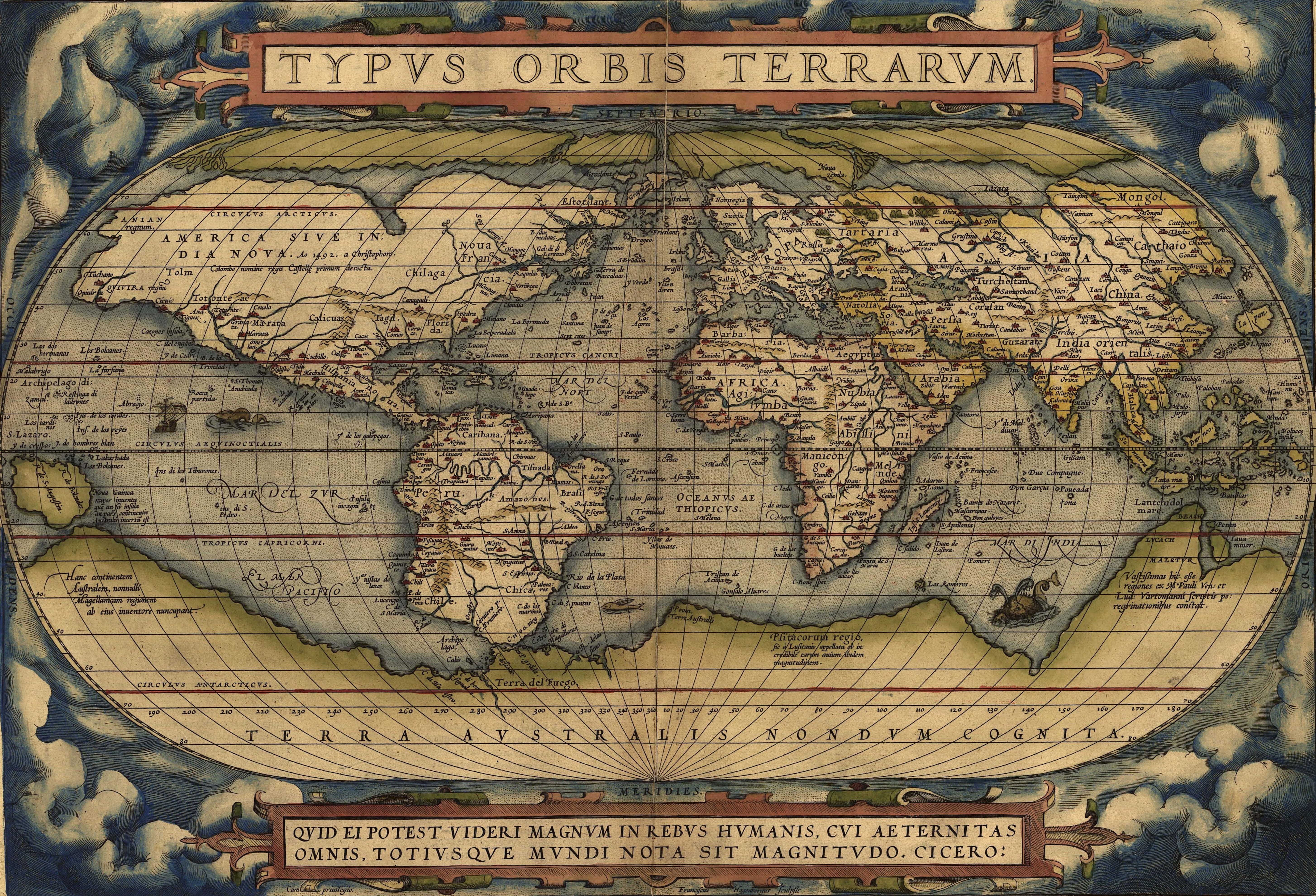
 Abraham Ortelius (1527-1598) was a Flemish cartographer who produced the first modern atlas, Theatrum Orbis Terrarum[1226], which at the time was reputed to have been the most expensive book ever printed.
It is interesting that he included the mythical island of Hi-Brasil (Brasil) off the coast of Ireland as well as the equally mysterious Frisland (Frieslant). Both can be clearly seen on his map using the link below(a).
In 1596 Ortelius was struck by the possibility that America, Europe and Africa had at one time been joined together but had over time become separated, an idea expressed in his Thesaurus Geographicus[1225]. Ortelius also included a speculative southern landmass, Terra Australis, which he designated as a “land of parrots”.
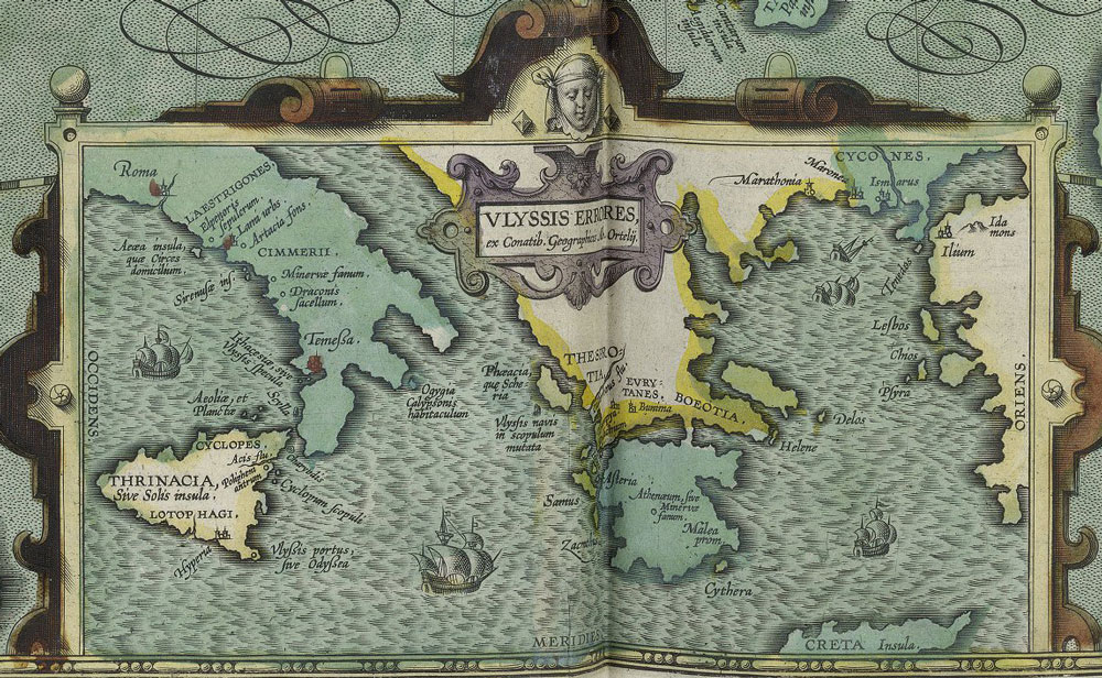
In 1597, Ortelius was the first to map(d) the travels of Homer’s Odysseus, notably locating all his adventures in the Central and Eastern Mediterranean, which was probably just a reflection of the limits of Greek maritime knowledge at the time that the narrative originated!
Ortelius suggested that Atlantis had been located in North America but that they had separated in the very distant past! Before modern theories of Continental Drift and its successor, Plate Tectonics, the idea of landbridges between continents was popular as an explanation for the spread of animals and people around the world. Some suggested as an alternative, the existence of lost continents such as Atlantis in the Atlantic, which acted as a stepping-stone between the continents(c).
Four hundred years later Alfred Wegener incorporated some of Ortelius’ ideas into his theory of Continental Drift, which later led to the current theory of Plate Tectonics.
A purpose-built polar exploration ship, m.v. Ortelius, was named after the geographer.
Recently, Doug Fisher has drawn attention to the similarities between a 1592 map of South America by Ortelius and the well-known Kircher map of Atlantis(b).
(a) https://upload.wikimedia.org/wikipedia/commons/e/e2/OrteliusWorldMap1570.jpg
(b) https://atlantismaps.com/chapter_7.html (link broken Oct. 2018) New website in development. (https://www.copheetheory.com/)
(c) Wayback Machine (archive.org) *
(d) https://www.laphamsquarterly.org/roundtable/geography-odyssey
Rockall
Rockall is an uninhabited islet in the North Atlantic, northwest of Donegal in Ireland. It appears to have been first marked on a map in 1640(c). It is first mentioned in literature in 1716 and referred to by locals as Rocabarraigh, which is also the name of “a mythical rock which is supposed to appear three times, the last being at the end of the world.”(m).
This ostensibly insignificant piece of stone is around 80ft by 100ft at the base and approximately
70ft in height. Nevertheless, its ownership is disputed by Ireland, Iceland, the Faroe Islands and the United Kingdom.
This international interest was motivated by disputed fishing rights, oil exploration and at one point by Cold War politics. “Keen to cement British ownership, Parliament voted to formally incorporate Rockall into the UK in 1972, making it part of Scotland’s Western Isles. However, no other nation recognised the UK’s claim. A further blow came in 1982 when the UN Convention of the Seas was ratified, effectively preventing uninhabited rocks without an economy from being used as the basis for territorial claims. This meant that ownership of Rockall would no longer be decisive in the battle for oil rights to the seabed below.”(n)
Rocabarraidh which was a mythic island referred to in the folklore of the Lordship of the Isles, a Scottish title, is generally accepted to be an early allusion to Rockall. The Atlantic rock is considered as part of the Hebridean parish of South Harris.
In June 1997, Greenpeace declared Rockall to be the independent state of Waveland(f).
Jean Deruelle credits Robert Graves with being the earliest, although only briefly, to consider the Rockall Bank as the location of Atlantis(e).
Recently, a new claim has been made in connection with Rockall, namely, that it is a remnant of the Atlantis highlands, with the plain so vividly described by Plato, now situated under the sea to the southwest of the rock. Two extensively illustrated French websites(a)(b) expound this theory. Which, however, are somewhat less than convincing. However, a 1938 newspaper report(d) suggests that a proposed linkage with Atlantis goes back much further!
In December 2016, Jonathan Northcote published 16.484ºW 58.521ºN, Atlantis, Found?[1369], in which he offers spirited support for this location using a mass of geological data and underwater topography. He also suggests that Gades may have been Ireland. In January 2019, Northcote revised his book with additional material and published this second edition with the title of Atlantis, Found? An investigation into ancient accounts, bathymetry and climatology [1611].
Stuart L. Harris, the prolific American researcher, has, in recent private correspondence with me, supported the vicinity of Rockall as the location of Atlantis, dating its demise to around 9577 BC. He later expanded on this in a highly speculative paper published on the Academia.edu website.
At the end of September 2018, the UK’s Daily Star, a well-known comic for adults, tried to revive the idea of Atlantis in Frisland(g). They based their brief article on the speculations of Matt Sibson, presented as an ‘expert’, who admits that “there are still some questions that need clearing up.” I would like to know why Frislanders in the middle of the last Ice Age would want to attack a non-existent Athens 4,000 km away. If Sibson is considered to be an expert historian, my cat is a brain surgeon. Jason Colavito had a few words to add regarding Sibson’s pathetic claims(h).
Incredibly, a week later the same ‘newspaper’ cited Sibson again, this time claiming that Rockall was the remains of Atlantis(i), an equally silly idea that is not new. The UK’s online Express recycled this nonsense in January 2020(k).
Kevin A. & Patrick J. Casey have published a series of papers on the Academia.edu website outlining a globally catastrophic event that occurred thirteen thousand years ago, which they refer to as the ’13K Event’, but is more popularly known as the onset of the Younger Dryas period. In February 2019, they published Atlantis Revisited (j), in which they claim that Rockall was the location of Atlantis.
Less extreme is a claim by John Esse Larsen that in support of the theory that Homer’s Odyssey refers to adventures in the North Atlantic he suggests that Rockall is referenced in Odyssey 10.513(l).
(a) https://web.archive.org/web/20191013063335/http://rockallatlantis.com/francais/cerclespiraleos.html
(c) http://web.archive.org/web/20240701000000*/http://adsabs.harvard.edu/full/1955IrAJ….3..202L
(e) https://www.q-mag.org/the-great-plain-of-atlantis-was-it-in-doggerland.html
(f) See: https://web.archive.org/web/20180420165734/https://www.waveland.org/history.html
(g) https://www.dailystar.co.uk/news/weird-news/732388/Atlantis-found-Brit-historian-sunken-lost-city-coast-Ireland-conspiracy-video (Link broken)
(h) https://www.jasoncolavito.com/blog/dissecting-this-past-weekends-faulty-claims-about-ancient-history
(i) Atlantis PICTURED? ‘Tip of lost city’ discovered by stunned historian – Daily Star (archive.org)
(j) https://www.academia.edu/38380799/13k_Theory_Atlantis_Revisited.pdf
(l) http://odisse.me.uk/rockall-the-monster-boulder-in-the-north-atlantic-2.html
(m) https://academickids.com/encyclopedia/index.php/Rockall
(n) https://www.bbc.com/culture/article/20250912-the-tiny-island-seized-by-britain-to-foil-the-ussr