Latest News

Joining The Dots
I have now published my new book, Joining The Dots, which offers a fresh look at the Atlantis mystery. I have addressed the critical questions of when, where and who, using Plato’s own words, tempered with some critical thinking and a modicum of common sense.Read More »
Abraham Ortelius
Odysseus & Herakles
Odysseus and Herakles are two of the best-known heroes in Greek mythology, both of whom had one important common experience, they each had to endure a series of twelve tests. However, although different versions of the narratives are to be found with understandable variations in detail, the two stories remain substantially the same.
The two tales have been generally interpreted geographically although a minority view is that an astronomical/astrological interpretation was intended, as the use of twelve events in both accounts would seem to point to a connection with the zodiac!
Alice A. Bailey is probably the best known regarding Hercules in her book The Labours of Hercules[1163], while Kenneth & Florence Wood have also proposed Homer’s work as a repository of astronomical data[0391]. Bailey’s work is available as a pdf file(d).
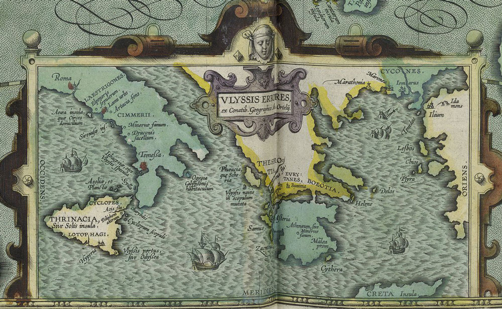
In geographical terms, Herakles and Odysseus share something rather intriguing. Nearly all of the ‘labours’ of Herakles (Peisander c 640 BC) and all of the ‘trials’ of Odysseus (Homer c.850 BC) are generally accepted to have taken place in the eastern Mediterranean. In fact, the first map of the geography of the Odyssey was produced by Ortelius in 1597, which situated all of the locations in the central and eastern Mediterranean(e).
However, in both accounts, there is a suggestion that they experienced at least one of their adventures in the extreme western Mediterranean, at what many consider to be the (only) location of the Pillars of Heracles as defined by Eratosthenes centuries later (c.200 BC). Significantly, nothing happens over the 1100-mile (1750 km) journey on the way there and nothing occurs on the way back!
I think it odd that both share this same single, apparently anomalous location. I suggest that we should consider the possibility that the accounts of Heracles and Odysseus are possibly distorted versions of each other and that, in the later accounts of their exploits, the use of the extreme western location for the trial/labour is possibly only manifestation of a blind acceptance of the geographical claims of Eratosthenes or a biased view that this was always the case. A credible geographical revision of the location of those inconsistent activities by Odysseus and Heracles to somewhere other than the Gibraltar region would add weight to those, such as myself, that consider a Central Mediterranean location for the ‘Pillars’ more likely.
Philipp Clüver spent some years surveying Italy and Sicily and concluded in his Sicilia Antiqua (1619) that the Homeric locations associated with the travels of Odysseus were to be found in Italy and Sicily(g) and that Homer identified Calypso’s Island (Ogygia) as Malta.
The University of Buffalo website offers a number of maps associated with a variety of theories relating to elements found in Homer’s epic poems(i).
The German historian, Armin Wolf, relates how his research over 40 years unearthed 80 theories on the geography of the Odyssey, of which around 30 were accompanied by maps. In 2009, he published, Homers Reise: Auf den Spuren des Odysseus[0669], a German language book that expands on the subject, concluding that all the wandering of Odysseus took place in the central and eastern Mediterranean. In a fascinating paper(a) he reviews many of these theories and offers his own conclusion on the subject, along with his own proposed maps, which exclude the western Mediterranean entirely. Wolfgang Geisthövel adopted Wolf’s conclusions in Homer’s Mediterranean [1578].
With regard to Hercules, the anomalous nature of the ‘traditional’ location of Erytheia for his 10th ‘labour’ is evident on a map(b), while the 11th could be anywhere in North Africa.
Further study of the two narratives might offer further strong evidence for a central Mediterranean location for the ‘Pillars’ around the time of Solon! For example, “map mistress” places Erytheia in the vicinity of Sicily(c), while my personal choice would be the Egadi Islands further to the north, Egadi being a cognate of Gades, frequently linked with Erytheia.
There is also a school of thought which suggests that most of Odysseus’ wanderings took place in the Black Sea. Anatoliy Zolotukhin is a leading exponent of this idea(f).
Wikipedia touched on the even more controversial suggestion that Odysseus had travelled in the Atlantic – “Strabo‘s opinion that Calypso’s island and Scheria were imagined by the poet as being ‘in the Atlantic Ocean’ has had significant influence on modern theorists. Henriette Mertz, a 20th-century author, argued that Circe’s island is Madeira, Calypso’s island one of the Azores, and the intervening travels record a discovery of North America: Scylla and Charybdis are in the Bay of Fundy, Scheria in the Caribbean.” (h)
(b) https://www.igreekmythology.com/Hercules-map-of-labors.html
(c) Pantelleria & Erytheia: Southwest Sicily Sunken Coastline to Tunisia (archive.org)
(d) https://www.bailey.it/files/Labours-of-Hercules.pdf
(e) https://www.laphamsquarterly.org/roundtable/geography-odyssey
(f) https://homerandatlantis.com/wp-content/uploads/2016/08/Scylla-CharybdisJAH-1.pdf
(g) https://journals.openedition.org/etudesanciennes/906
(h) Geography of the Odyssey – Wikipedia *
(i) INDICES (buffalo.edu) *
Expanding Earth Hypothesis
The Expanding Earth Hypothesis.
For thousands of years, it was accepted that the surface of the earth was in a static state. This belief persisted until the rediscovery of America in 1492 and the cartographic improvements during the following century, before Abraham Ortelius in his 1596 Thesaurus Geographicus[1225] proposed that the Americas had once been joined to Europe and Africa. It is often claimed that in 1620 Francis Bacon commented on the close fit of eastern South America with the west coast of Africa; however, this, according to G.L. Herries Davies, is an exaggerated interpretation of what he actually said(o).
A number of others concurred with the jig-saw suggestion until 1858, when the French geographer Antonio Snider-Pellegrini offered[0555] a theory of crustal movement that was more fully developed in 1912 by Alfred Wegener, which he came to label ‘continental drift’(e). Snider-Pellegrini also thought that the Earth had been much smaller at the time of the biblical Genesis(ac)! The big objection to the theory was a lack of a convincing mechanism to explain it(f).
 A number of writers have attempted to bring the theory of Continental Drift (CD) into the Atlantis debate. They seem to overlook the fact that CD was proposed as a very slow process, while Plato describes the demise of Atlantis as occurring in a single day and a night.
Wegener’s theory was debated until the late 1950s when it morphed into the theory of Plate Tectonics (PT) following new developments in earth sciences, in particular the recognition of seafloor spreading at mid-ocean ridges. However, PT as we know it demands subduction(z), which in itself has created new problems(aa)(ab).
The theory PT theory divides the lithosphere into a number of plates that are constantly moving in various directions at rates of a few centimetres a year. Competing with PT in the early years was the theory of Earth Crustal Displacement, advocated by Charles Hapgood, which claims that the entire crust of the earth moved as a unit. Endorsed by Albert Einstein, it is fundamental to the theory of an Antarctic location for Atlantis proposed by Rose & Rand Flem-Ath.
Unfortunately, Plate Tectonics does not explain everything and ever since it gained the pre-eminence it currently enjoys, various writers have questioned what they perceive as its shortcomings(g)(h)(i).
A totally different proposal is that the earth is expanding. Although the concept did not get much attention until the 1980’s there are antecedents stretching back to 1888(a), when the earliest suggestion was made by the Russian, Ivan Yarkovsky (1844-1902). A year later, the Italian geologist (and violinist) Roberto Montovani (1854-1933) proposed(I) a similar mechanism. In 1933, Ott Christoph Hilgenberg(t) published Vom wachsenden Erdbal (The Expanding Earth) [1328].
In 1963, a Russian lady, Kamilla Abaturova, wrote to Egerton Sykes expressing the view that although her theory of an expanding Earth involved a ‘slow’ process, she proposed that at the time of Atlantis, the radius of the Earth was 600 km shorter(af). In geological terms, this is far from ‘slow’!
The leading proponent of the theory today is arguably the, now retired, geologist Dr James Maxlow(b). A detailed outline of the theory is also offered on his website(c). For laymen like myself, a series of YouTube clips(d) are probably more informative. I have stated elsewhere that I am sympathetic towards the idea of earth expansion, finding it somewhat more credible than plate tectonics. The truth of the matter is that since Ortelius first suggested that the continents of our planet had moved, all that has emerged since is a refinement of that basic idea, leading to CD, which became PT and as the latter still does not answer all the questions it raises, it is clear that further modification will be required. In December 2021, Maxlow published an overview of his current thinking on Expansion Tectonics(ag).
The Expanding Earth Hypothesis may, as its proponents claim, supply all those answers. Others do not think so, which brings me to J. Marvin Herndon, who has ‘married’ the theory of an expanding earth with the idea of crustal plates(j) , naming his 2005 concept Whole-Earth Decompression Dynamics (WEDD).
The Thunderbolts.info website has a three-part article seeking to offer “an alternative to plate and extension tectonics”. The anonymous author suggests that an electrical element is involved in the development of our planet. An extensive look at mountain building is also included(y).
A 1998 paper(ah). by Bill Mundy, an American Professor of Physics, is still relevant. In it, he discusses the pros and cons of both plate tectonics and the expanding earth hypothesis and concludes that “Despite the success that standard plate-tectonics theory has enjoyed, there are phenomena that it currently is not able to model. Perhaps the most adequate model would incorporate Owens’ suggestion that there is both subduction and expansion. This would allow the earth to expand at a modest rate with reasonable changes in surface gravitation and also require some subduction for which the evidence seems convincing. But such a model presents the difficulty of finding suitable mechanisms for expansion, plate motion and subduction!”
In October 2022, Doug Fisher published a paper on Graham Hancock’s website, highlighting weaknesses in the generally accepted theory of plate tectonics and seeking a review of the expanding earth hypothesis(ai).
Keith Wilson, an American researcher, has also developed a website(k) devoted to the EEH and linked it to Pole Shift. However, he goes further and introduces Mayan prophecies into the subject, which in my view is unwise in the light of recent events or rather non-events!
In the meantime, a number of Atlantis researchers have endorsed the EEH including Stan Deyo, Georg Lohle and Rosario Vieni. Nicolai Zhirov referred to the growing support both in Russia and elsewhere for the EEH, citing a number of its supporters, adding that “the idea of the Earth expanding (within reasonable limits) cannot be ruled out altogether as absurd.”[458.126]
A number of websites have dismissed the EEH as pseudoscience, which is confirmed by satellite measurements(m)(n).
There is also a variation of the standard expansion theory which proposes(q) that expansion may have occurred in fits and starts. There also seems to be evidence that the Earth is not alone with Venus expanding(r) and Mercury contracting(s).
Another matter that may be related to the claim of an expanding Earth is the question of the size of dinosaurs and other creatures and plants millions of years ago, which is claimed to have been impossible if gravity then was the same as today. A book[1218] by Stephen Hurrell has expanded on this idea. There is an interesting website(p) that deals with the enormous size of the dinosaurs as well as other creatures at the same period and the support it may offer the EEH.
Neal Adams, a respected graphic artist(u), is a vocal supporter of the EEH(v), but he has gone further and has also proposed a growing Moon as well(w). Not content with that, he has extended his expansion investigations to other bodies in our Solar System, such as, Mars, Ganymede & Europa(x). Adams considers the term “Expanding Earth” a misnomer and has named his proposed expansion process ‘pair production’.(ad)
A December 2018 paper by Degezelle Marvin offers some new support for the EEH(ae). The author includes an interesting comparison of the problems of the currently accepted paradigm of plate tectonics with possible solutions offered by EEH. The author concludes with;
“The problems with plate tectonics were presented in this paper. Earth scientists dogmatically follow the plate tectonics theory that is falsified by geological data, while Earth expansion is clearly a viable candidate to replace plate tectonics. Analysis map of the age of the oceanic lithosphere showed that the isochrons only fit on a smaller Earth with a calculated radius. Mountain formation has even been presented as a logical result of the Earth’s expansion. The average rate of the growth of the Earth’s radius is 1.22cm/year, obtained by geological methods.”
Finally, I cannot help thinking about those Victorians who thought that they had reached the pinnacle of scientific understanding. They were wrong and, I believe that so are we, although we are slowly, very slowly, edging towards the truth, which may or may not involve the vindication of the Expanding Earth Hypothesis.
(a) https://www.checktheevidence.co.uk/cms/index.php?option=com_content&task=view&id=394&Itemid=59
(b) http://web.archive.org/web/20181118180608/http://www.expansiontectonics.com/page2.html See Expansion Tectonics – Page 1
(c) http://web.archive.org/web/20181118180655/http://www.expansiontectonics.com/page3.html See: Expansion Tectonics – Page 1
(d) https://www.youtube.com/watch?v=OUkEu6YYR3s
(e) https://en.wikipedia.org/wiki/Continental_drift
(f) https://www.scientus.org/Wegener-Continental-Drift.html
(g) https://davidpratt.info/ncgt-jse.htm
(h) https://davidpratt.info/lowman.htm
(i) https://www.newgeology.us/presentation21.html
(j) https://web.archive.org/web/20200926204322/http://nuclearplanet.com/
(k) http://web.archive.org/web/20251209205244/https://www.eearthk.com/
(l) https://en.wikipedia.org/wiki/Roberto_Mantovani
(n) https://blogs.scientificamerican.com/history-of-geology/2014/05/12/the-expanding-earth/
(o) Francis Bacon and Continental Drift (archive.org)
(p) The Inflating Earth: 4 – Gravity | MalagaBay (archive.org)
(q) https://web.archive.org/web/20161203151134/http://www.xearththeory.com/expansion/
(r) https://web.archive.org/web/20200808000231/https://www.xearththeory.com/expanding-venus/
(s) https://web.archive.org/web/20200807234839/https://www.xearththeory.com/mercury/
(u) https://en.wikipedia.org/wiki/Neal_Adams
(w) Neal Adams: 02 – The Growing Moon | MalagaBay (archive.org)
(x) https://www.youtube.com/watch?v=zy3_sWF7tv4
(y) http://www.thunderbolts.info/forum/phpBB3/viewtopic.php?f=4&t=16534
See: http://web.archive.org/web/20191216195724/https://atlantipedia.ie/samples/archive-3326/
(z) https://www.thoughtco.com/what-is-subduction-3892831
(aa) https://www.newgeology.us/presentation8.html
(ad) https://malagabay.wordpress.com/2015/12/17/neal-adams-01-the-growing-earth/
(af) Atlantis, Volume 16, No. 1, February 1963.
(ag) NCGTJV9N4_Pub.pdf (registeredsite.com)
(ah) https://www.grisda.org/assets/public/publications/origins/15053.pdf
(ai) Maps, Myths & Paradigms – Graham Hancock Official Website
Homer
Homer (c. 8th cent. BC) is generally accepted as the author of the Iliad and the Odyssey, regarded as the two greatest epic poems of ancient Greece. A recent study of the Greek used by Homer has enabled scientists from the University of Reading to confirm that the language used is compatible with that used in the 8th century BC, in fact dating it to around 762 BC(i).
Nevertheless, there are questions raised regarding the authorship of the ‘Homeric’ epics. For example, Andreas Pääbo is certain that the Odyssey and the Iliad came from two different authors(ar).
Even more extreme was the opinion of the ancient geographer, Eratosthenes, who was a persistent critic of Homer, whom he considered to be a fantasist. Strabo reported what the geographer said in the late 3rd century BC: “You will find the scene of Odysseus’ wanderings when you find the cobbler who sewed up the bag of winds”(av).
Manolis Manoledakis, a professor of Classical Archaeology, in a paper(as) on the Academia website examines “an aspect of the broader issue of the geography of the Odyssey, the primary stimulus being the references of the poem to places that could be associated with the Black Sea, namely the Aeaea and the entrance to the Underworld. As we shall see, while these particular places are indeed relevant to the Black Sea region, they do not belong to the context of a specific journey with specific halts in a specific geographical sequence. The Odyssey is a synthesis of many different episodes, and there is no point in trying to trace a complete geographical course for Odysseus’ voyage.”
It should also be noted that over 130 quotations from the Illiad and Odyssey have been identified in Plato’s writings(s). George Edwin Howes (1865-1942), an American classicist, produced a dissertation[1458]+ on Homeric quotations in Plato and Aristotle.
Almost nothing is known of Homer’s life. He has been variously described as mad, blind and even mythical. Andrew Dalby, the English linguist, has gone so far as to claim[0591] that the author of the two famed epics was a woman! While in 1897 Samuel Butler, the novelist, was even more specific when he proposed that Homer was a Sicilian woman(j).
For centuries it was assumed that the content of these Homeric poems was the product of his imagination, just as the historical reality of Homer himself has been questioned. In 1795, F.A. Wolf, a German academic declared that ‘Homer’ was just a collective name applied to various 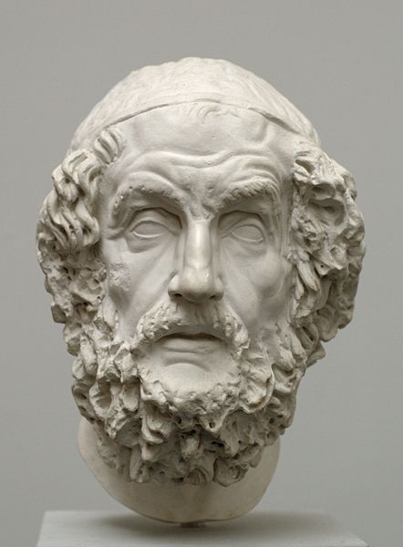 poets whose works were finally combined into their present form in the 6th century BC. Wolf’s ideas sparked furious argument among Greek scholars that still resonates today. Now (2015), historian, Adam Nicholson has claimed that the author ‘Homer’ should not be thought of as a person but instead as a ‘culture’(o).
In a 2021 review of Victor Davis Hanson’s, Who Killed Homer? [1854], Adam Kirsch outlines how “Milman Perry proved that the Iliad and the Odyssey were not written by a lone genius(ah). They were originally not written at all, but through fieldwork in Yugoslavia, Perry (1902-1935) demonstrated how the Homeric epics were the result of traditional bardic storytelling. Wikipedia describes Perry as “an American Classicist whose theories on the origin of Homer’s works have revolutionized Homeric studies to such a fundamental degree that he has been described as the ‘Darwin of Homeric studies’.”
Ed Whelan, an Irish classical scholar, published a brief paper in 2021 which endorsed the Homeric ‘multiple authors’ theory(ap).
An anonymous author offered, “Although there has been a great deal of controversy about the question of whether Homer alone wrote the two famous poems, much of the evidence points towards Homer being the author due to the consistent style of writing. Also, some analysts argue that Homer may have written one of the poems but not the other since both differ greatly in style. In contrast, the reason other analysts state for this difference is that Iliad was written in his youth while Odyssey was created during Homer’s years of age.” (aq).
The identification of the site at Hissarlik in modern Turkey as Troy, by Heinrich Schliemann, led to a complete re-appraisal of Homer’s work and, of course, further controversy. Homer’s Iliad is the story of the Trojan War and it has been suggested that in fact, he had compressed three or more Trojan wars into one narrative. What is not generally known is that there are also ancient non-Homeric accounts of the Trojan War(q).
Kenneth Wood and his wife Florence have built on the research of his mother-in-law, the late Edna Leigh, and produced Homer’s Secret Iliad[391], a book that attempts to prove that the Iliad was written as an aide-memoire for a wide range of astronomical data.
Allied to, but not directly comparable with, is the astronomical information identified in the Bible by the likes of E. W. Maunder (1851-1928)[1137].
Guy Gervis has adopted some of their work and, in a lengthy article, specifies a date of around 2300 BC, for the events described in the Iliad and Odyssey, based on an analysis of this astronomical data(n). Harald A.T. Reiche held similar views which followed some of the ideas expressed in Hamlet’s Mill[0524] by Santillana & Dechend who were colleagues of Reiche at M.I.T. They also claimed that “myths were vehicles for memorising and transmitting certain kinds of astronomical and cosmological information.”
Much has been written about the historicity of Homer’s epic accounts, including a good overview on Wikipedia(ab). Many have concluded that Homer did use real events, even if they were frequently dressed in mythological clothing compatible with the literary conventions of his day. I consider Plato to have treated the story of Atlantis similarly.
A recent study of solar eclipses recorded in Odyssey using data from NASA has confirmed that Odysseus returned to Ithaca on the 25th of October 1207 BC(r).
Scholars have generally supported the idea that Homer’s works have a Mediterranean backdrop with regular attempts to reconcile his geography with modern locations, such as the claim in 2005 by Robert Brittlestone, a British investigator to have located the site of Ithaca, the homeland of Odysseus, on the Greek island of Cephalonia. This popular idea should be put alongside the views of Zlatko Mandzuka who maintains[1396] that all the locations mentioned in the Odyssey can be identified in the Adriatic.
Kazmer Ujvarosy, of San Francisco State University, has noted that there are 22 different places currently on offer as the location of Ithaca(ax).
Nevertheless, there has been a growing body of opinion that insists that this Mediterranean identification is impossible. A range of alternative regions has been proposed(f) as the setting for the epics, which extend from Portugal as far northward as the Baltic.
Wikipedia touched on the even more controversial suggestion that Odysseus had travelled in the Atlantic – “Strabo‘s opinion that Calypso’s island and Scheria were imagined by the poet as being ‘in the Atlantic Ocean’ has had significant influence on modern theorists. Henriette Mertz, a 20th-century author, argued that Circe’s island is Madeira, Calypso’s island one of the Azores, and the intervening travels record a discovery of North America: Scylla and Charybdis are in the Bay of Fundy, Scheria in the Caribbean.” (ay)
The University of Buffalo website offers a number of maps associated with a variety of theories relating to elements found in Homer’s epic poems(az)*.<<
In his Odyssey (VII: 80), Homer wrote about the island of Scheria in the western sea. His description of the island has been compared with Plato’s description of Atlantis and has led to the theory that they refer to the same place. There is little doubt that both the detailed geography and climatic descriptions that are provided by Homer cannot be easily reconciled with that of the Mediterranean. Consequently, the Odyssey has had many interpretations, ranging from Tim Severin’s conclusion[392] that it refers entirely to the Eastern Mediterranean to Iman Wilkens’ book, Where Troy Once Stood[610], which has the voyage include the west coast of Africa, then across to the West Indies and following the Gulf Stream returns to Troy which he locates in Britain.
Location is not a problem exclusive to the writings of Plato. Wilkins’s claims are a reflection of similar ideas expressed by Théophile Cailleux[393] in the 19th century. Gilbert Pillot has also argued for voyages of Ulysses having taken him into the North Atlantic [742]. A Spanish review of Pillot’s book is available(ag). In 1973, Ernst Gideon (? – 1975) wrote in a similar vein in Homerus Zanger der Kelten, reprinted later as Troje Lag in Engelan[1643].
It is worth noting that Bernard Jones in The Discovery of Troy[1638] has recently moved Troy to Britain, probably in the vicinity of Cambridge, a location also preferred by Wilkens! Like many others, he argues that Homer’s Iliad and Odyssey were not set in the Mediterraneanx, as so many of the details that he provides are incompatible with the characteristics of that sea. However, Jones has gone further and claimed that there are details in Virgil’s Aeneid, which are equally inconsistent with the Mediterranean [p.6-10], requiring a new location! Jones’ book has been reviewed on the Hall of Maat website(at) as well as by Jason Colavito(au).
An interesting overview of the various attempts to transfer the Odyssey from the Mediterranean to Northern Europe is available(w). Damien Mackey has also endorsed the idea of a Northern European backdrop to Homer’s Odyssey(aa).
Another researcher who places most of Odysseus’ travels in the eastern Atlantic is Gerard. W.J. Janssen of Leiden University on the academia.edu website(v). In a series of six papers(ai-an), he systematically reviews Homer’s geography, identifying locations referred to by him with places in the Atlantic. He compares his identifications with other commentators including Iman Wilkens and Théophile Cailleux. His website, with an English translation, offers additional information, including the suggestion(ao) that Homer’s Laestrygonians were to be found in Cuba, an interpretation also offered by Cailleux and Wilkens. They also claim that Odysseus’ Caribbean trip included a visit to Saba, a Dutch possession, which is identified as the Aeolian Isle!
The idea of an Atlantic backdrop to the Homeric epics will not go away. The Dutch researcher, N.R. De Graaf(ae). continues to write extensively on his Homeros Explorations website(ad)(x) regarding many of the specifics in Homer’s accounts. He has proposed Lanzarote in the Canaries as the location of Scheria, which concurs with the views of Wilkens and Janssen. Other specifics are that Ithaca was near Cadiz and that Sparta was Cordoba, while the ancient city of Carmona on the plains of Andalucia are, for De Graaf, Mycenae!(af)
E.J. de Meester also argued(ac) for the British Isles as the location of many of Homer’s references. It struck me as quite remarkable that the level of debate regarding the date, source and geographical details of Homer’s works is rather similar to the controversy surrounding Plato’s Atlantis in Timaeus and Critias. The late Edo Nyland was another researcher who had also opted for a Scottish backdrop to the Odyssey and had recently published his views[394].
Felice Vinci also supports[019] a Northern European background to the Iliad and Odyssey. However, in Vinci’s case, Scandinavia, and in particular the Baltic Sea, is identified as the location for the adventures in Homer’s classic. An English language synopsis of his book is available on the Internet. The persuasiveness of Vinci’s argument has recently renewed interest in the idea of a Baltic Atlantis. The assumption is that if Troy could be located in the Baltic, so might Atlantis. Vinci’s views are comparable with those of J. Rendel Harris expressed in a lecture delivered in 1924(p) in which he claims that “we are entitled to take Homer and his Odysseus out of the Mediterranean or the Black Sea, and to allow them excursions into Northern latitudes.”
However, a scathing review of Vinci’s book can be found on the Internet(d) and in issue 216 (2006) of Fortean Times written by Marinus Anthony van der Sluijs.
Further support for a Northern European Troy has come from the historian Edward Furlong, a former naval navigation officer, who has advocated for over twenty years that the journey of Odysseus went as far north as Norway after visting, Ireland and the Scottish Islands. His particular views are outlined on the Internet(c).
Other writers, such as the late Henrietta Mertz [0396/7], have suggested that Homer’s epic refers to a trip to North America. Professor Enrico Mattievich Kucich of Lima University is also certain that the ancient Greeks discovered America America[400]. However revolutionary this idea may seem it shows how this particular subject is growing and would probably justify a reference book of its own.
The idea of an Atlantic backdrop to the Homeric epics will not go away. The Dutch researcher, N.R. De Graaf continues to write extensively on his Homeros Explorations website(x) regarding many of the specifics in Homer’s accounts.
In 1973, James Bailey also proposed in his well-received The God-Kings and the Titans[149] that the Odyssey recorded a trans-Atlantic trip. Evidence exists for large-scale mining in the Americas as early as the 5th millennium BC. Bailey maintained that the Europeans imported enormous quantities of copper and tin from Central and South America to feed the demands of the Old World Bronze Age, an idea that was later heavily promoted by Frank Joseph and in great, if overly speculative, detail by Reinoud de Jong(y).
Michael MacRae in Sun Boat: Odyssey Deciphered [985] goes even further with the suggestion that Odysseus had not only crossed the Atlantic, but, for good measure, the Pacific as well(ba).
Finally, the Atlantis connection with this entry is that if, as now appears to be at least a possibility, Homer’s Odyssey was about a journey to the North Sea, then the possibility of the North Sea setting for the Atlantis story is somewhat reinforced.
A recent book[395] by Steven Sora has developed the Atlantic notion further with the suggestion that not only was Troy located outside the Strait of Gibraltar but that both Homer’s Trojan War and Plato’s Atlantean war are two versions of the same war, with the understandable distortions and embellishments that can occur with a narrative, probably involving some degree of oral transmission and then written down hundreds of years after the events concerned.
Ukraine is soon to be added to the growing list of alternative locations for the setting of Homer’s epics with the publication of Homer, The Immanent Biography, a book by A.I. Zolotukhin(g). He claims that Homer was born in Alibant (Mykolayiv, Ukraine) on September 14, 657 BC(t). He follows the views of Karl Ernst von Baer (1792-1876) who believed that most of Odysseus’s travels took place in the Black Sea rather than the Mediterranean. Additionally, he locates Atlantis in the western Crimean area of Evpatoria(l). His 60-page book is available on his website(m).
An interesting paper(e) by the German historian, Armin Wolf, relates how his research over 40 years unearthed 80 theories on the geography of the Odyssey, of which around 30 were accompanied by maps. One of the earliest maps of the travels of Odysseus was produced by Abraham Ortelius in 1597(u), in which the adventures of Odysseus all take place within the Central and Eastern Mediterranean, arguably reflecting the maritime limits of Greek experience at the time of Homer or his sources! Another website(z) by Jonathan S. Burgess, Professor of Classics at the University of Toronto offers further information on this, including some informative bibliographical material.
In 2009, Wolf published, Homers Reise: Auf den Spuren des Odysseus[669] a German-language book that expands on the subject, also locating all the travels of Odysseus within the Central and Eastern Mediterranean.
Wolf’s ideas were enthusiastically adopted by Wolfgang Geisthövel in Homer’s Mediterranean[1578], who also concurs with the opinion of J.V. Luce [1579], who proposed that Homer was “describing fictional events against authentic backgrounds.” This would be comparable to a James Bond movie, which has an invented storyline set in actual exotic locations around the world.
Perhaps the most radical suggestion has come from the Italian writer, Michele Manher, who has proposed(h) that Homer’s Iliad originated in India, where elements of it can be identified in the Mahabharata!
In August 2015, a fifteen-hour reading of the Iliad was performed in London.
[1458]+ https://archive.org/stream/jstor-310358/310358_djvu.txt
(c) https://www.academia.edu/8167048/WHERE_DID_ODYSSEUS_GO_
(d) https://mythopedia.info/Vinci-review.pdf
(e) https://authorzilla.com/9AbvV/armin-wolf-mapping-homer-39-s-odyssey-research-notebooks.html (link broken)
(f) https://codexceltica.blogspot.com/search?q=atlantis
(g) https://pushkinclub.homerandatlantis.com/english/homer.html
(h) https://www.migration-diffusion.info/article.php?id=100
(i) https://www.insidescience.org/content/geneticists-estimate-publication-date-iliad/946
(j) https://www.sacred-texts.com/cla/aoto/index.htm
(k) https://web.archive.org/web/20180320072706/https://www.nwepexplore.com (see ‘n’)
(l) https://homerandatlantis.com/?lang=en
(m) Wayback Machine (archive.org) *
(n) https://web.archive.org/web/20180320072706/https://www.nwepexplore.com
(o) https://www.newser.com/story/200859/homer-wasnt-a-person-historian.html
(p) https://www.escholar.manchester.ac.uk/api/datastream?publicationPid=uk-ac-man-scw:1m1163&datastreamId=POST-PEER-REVIEW-PUBLISHERS-DOCUMENT.PDF (link broken)
(q) https://luwianstudies.org/the-homeric-epics/
(r) Scientists provide evidence that Homer´s Odyssey is not fiction (archive.org)
(s) https://plato-dialogues.org/tools/char/homerqot.htm
(t) https://homerandatlantis.com/?p=4938&lang=en
(u) https://kottke.org/19/03/mapping-the-odyssey-isnt-easy
(v) https://www.academia.edu/38535990/ATLANTIC_OGUGIA_AND_KALUPSO?email_work_card=view-paper
(w) https://codexceltica.blogspot.com/2009/10/homers-north-atlantic-odyssey.html
(x) http://www.homeros-explorations.nl/
(y) https://www.academia.edu/3894415/COPPER_AND_TIN_FROM_AMERICA_c.2500-1200_BC_
(z) https://wakeofodysseus.com/
(ab) https://en.wikipedia.org/wiki/Historicity_of_the_Homeric_epics#History
(ac) https://web.archive.org/web/20090907222615/https://home-3.tiscali.nl/~meester7/engodyssey.html
(ad) Homeros Explorations – Homer, facts or fiction? (homeros-explorations.nl)
(ae) https://www.homeros-explorations.nl
(af) Mycenae, rich in gold – Homeros Explorations (homeros-explorations.nl)
(ag) Perijóresis: Odisea (perijoresis.blogspot.com) (Spanish)
(ah) https://www.newyorker.com/magazine/2021/06/14/the-classicist-who-killed-homer
(ai) https://www.academia.edu/40668880/ATLANTIC_GEOGRAPHY_IN_HOMER_I
(aj) https://www.academia.edu/40849368/ATLANTIC_GEOGRAPHY_IN_HOMER_II
(ak) https://www.academia.edu/40982169/ATLANTIC_GEOGRAPHY_IN_HOMER_III
(al) https://www.academia.edu/41200642/ATLANTIC_GEOGRAPHY_IN_HOMER_IV
(am) https://www.academia.edu/41474241/ATLANTIC_GEOGRAPHY_IN_HOMER_PART_V
(an) https://www.academia.edu/41625852/ATLANTIC_GEOGRAPHY_IN_HOMER_PART_VI
(ao) LAISTRUGONIACUBA, LA HAVANA (homerusodyssee.nl)
(ap) The Homeric Question – Who WAS Homer? (bibliotecapleyades.net)
(aq) Homer | Biography, Books and Facts (famousauthors.org)
(ar) (26) The Odyssey’s Northern Origins and a Different Author Than Homer | Andres Pääbo – Academia.edu
(at) http://www.hallofmaat.com/migrations/the-discovery-of-troy-and-its-lost-history/
(av) Strabo 1.2.15
Sea of Kronos
The Sea of Kronos (Cronos), according to modern researchers such as Alan Alford and Frank Joseph as well as Immanuel Velikovsky, is a name frequently applied to the Atlantic Ocean by ancient writers. Velikovsky cites Plutarch, Clement of Alexandria and Aristotle in support of this contention(a). If Plato believed that Atlantis had been located in the Atlantic why did he not simply say that it was situated in the Okeanos or the Sea of Kronos?
The 1624 Argonautica Map by Abraham Ortelius has the Adriatic Sea designated as ‘Cronivm Mare’. Eratosthenes in his Map of the Oecumene referred to the frozen Cronian Sea as being seven days north of Britain. Diodorus Siculus (Bk.III 61.3) describes Kronos as lord of Sicily, Libya and Italy!
Until it can be shown otherwise, I am inclined to think that Plato did not know precisely where Atlantis had been located but used the term ‘beyond the Pillars of Herakles’ as indicative of a place outside the ambit of what was common Greek maritime knowledge at that time!
>However, Plato was aware that Atlantean territory included part of North Africa, Southern Italy and some of the islands in that region (Tim 25a). Not only does this imply that, according to Diodorus, Atlantis was ruled by Kronos, but that the Pilllars were east of that realm!<
Kircher, Athanasius
 Fr. Athanasius Kircher (1602-1680) was a German Jesuit scholar and a professor of ethics and mathematics at the University of Würzburg. In his day, he was considered one of the greatest authorities in Europe on Chinese and Egyptian cultures, archaeology, ancient languages and astronomy. However, he was not without his detractors, one of whom was Descartes, who robustly attacked Kircher’s scientific abilities. Kircher’s writings filled 44 folio volumes.
Kircher claimed to have deciphered the ancient Egyptian hieroglyphics, but this was later shown to be unfounded and drew highly critical comments such as that of the Egyptologist Sir E. A. Wallis Budge who wrote in 1910: Many writers pretended to have found the key to the hieroglyphics, and many more professed, with a shameless impudence which is hard to understand in these days, to translate the contents of the texts into a modern tongue. Foremost among such pretenders must be mentioned Athanasius Kircher, who, in the 17th century, declared that he had found the key to the hieroglyphic inscriptions; the translations which he prints in his Oedipus Aegyptiacus are utter nonsense, but as they were put forth in a learned tongue many people at the time believed they were correct. A more recent critique is available online(b).
When it is realised that more than a century was to pass after Kircher’s death before the Rosetta Stone was discovered and the work of Champollion finally gave us a reliable decipherment of Egyptian hieroglyphics, it is quite reasonable to treat Kircher’s translation as purely speculative. His efforts in this regard were recently described as ‘illusory’.
In recent times, Kircher has regained widespread fame because of the map, published in his Mundus  Subterraneus [1203], which, among a range of subjects(c), outlines Atlantis (Insula Atlantis) between Africa and America. This Latin text can now be read or downloaded online(a). A 1678 edition of the book held in the Fagel Collection in Trinity College, Dublin, has been described as one of the most beautiful books in the collection(h).
In Mundus Subterraneus, Kircher was the first to propose that the Canaries and the Azores were the mountain peaks of sunken Atlantis. His famous map has the north shown at the bottom with Africa and Spain on the left and America on the right. There is no particular significance in this fact, as the convention of having North at the top of maps is relatively recent and generally attributed to the controversial 8th-century Irish cleric, Virgil of Salzburg, who was eventually appointed bishop of that city and later canonised as St. Virgilius. A Latin label on the map reads: “site of Atlantis, now beneath the sea, according to the beliefs of the Egyptians and the description of Plato. A chart based on beliefs and descriptions clearly shows that his offering is speculative and not a real map, although some claim that it is an ‘authentic’ depiction of Atlantis, such as can be seen on an hour-long YouTube video from a 1997 conference(g).
Despite being based on speculation, Kircher’s map is still widely used today. An article by Phil Edwards has commented on its continued use – ” We can only guess why one map became the iconic depiction of Atlantis, but there are a few reasonable assumptions. It had a veneer of scientific legitimacy, thanks to Kircher’s reputation and other work. It came at a time when the world was actively being reimagined. And Kircher’s map was one of the earliest ones nestled into an otherwise accurate depiction of the world. And perhaps most important is that once Atlantis’s appearance was established it couldn’t really be disproven. So the same map stuck around for centuries” (l).
Recently, Doug Fisher>>and Johan Nygren(m) have<<drawn attention to the similarities between a 1592 map of South America by Abraham Ortelius and Kircher’s Atlantis map when inverted(e). Frank Jacobs has highlighted the same comparison but also notes how the map might be seen as an image of Greenland(i). Some further background information on Kircher’s map is to be found online(f).
Kircher’s Atlantis map is widely used, particularly by supporters of an Atlantic Atlantis. Some, such as Dieter Thom, have followed Kircher’s view that Atlantis had been located in the Azores, while others have been more liberal in their interpretation of the map. Dale Huffman, Johan Nygren and Mario Dantas have associated the map with Greenland. Ian A. Fox has pushed matters further by nominating Baffin Bay west of Greenland as formerly the Plain of Atlantis. Now, while all these have kept their chosen Atlantis locations within the Atlantic Ocean, conforming, at least to some extent, with Kircher’s map. However, there are a number of commentators who have employed the map to justify even more exotic locations. At one end of the world, Rand and Rose Flem-Ath were apparently, inspired by Kircher’s map and opted for an Antarctic Atlantis, while at the other end, just south of the Arctic Circle, Marco Francesco Bulloni has nominated the Solovetsky archipelago in northwest Russia as the home of Atlantis, once again inspired by Kircher. Of course, I’ve saved the best for last with Australia as the nominee and a specific location of Port Arthur in Tasmania(k).
Less known is his 1665 world map recently published on the atlan.org. website(j).
![]() In 2004 a book[425] with the enticing title of Athanasius Kircher: The Last Man Who Knew Everything was published. It was edited by Paula Findlen and includes essays by leading historians of our day.
In 2004 a book[425] with the enticing title of Athanasius Kircher: The Last Man Who Knew Everything was published. It was edited by Paula Findlen and includes essays by leading historians of our day.
(a) https://archive.org/details/mundussubterrane02kirc
(b) https://publicdomainreview.org/2013/05/16/athanasius-kircher-and-the-hieroglyphic-sphinx/
(c) https://publicdomainreview.org/2012/11/01/athanasius-underground/
(e) https://atlantismaps.com/chapter_7.html (Link broken Nov. 2018) New replacement site is now being developed – https://www.copheetheory.com/
(f) https://www.vox.com/2015/4/30/8516829/imaginary-island-atlantis-map-kircher
(g) https://www.youtube.com/watch?v=DZcuJKilUdw
(h) The Fagel Collection (archive.org)
(i) Could South America be Atlantis? – Big Think
(k) The location of Atlantis, page 1 (archive.org) (The map was not saved by Wayback Machine)
(l) https://www.vox.com/2015/4/30/8516829/imaginary-island-atlantis-map-kircher
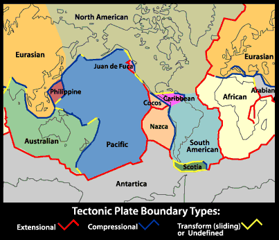
Plate Tectonics
Plate Tectonics is the name given to the widely accepted geological theory that explains the observable fact of continental drift. Abraham Ortelius, a 16th-century cartographer was one of the first to suggest that Africa, Europe and the Americas had at one time been joined together. In the 17th century Sir Francis Bacon is claimed to have been similarly struck by the complementary profiles of South America and Africa, but this, according to G.L. Herries Davies, is an exaggeration of what Bacon actually wrote(j). Alexander von Humboldt writing at the end of the 18th century, also commented that the ”lands bordering the Atlantic Ocean had once been joined.” Decades later Snider-Pellegrini expressed similar ideas that eventually led to the theories of ‘continental drift’ and plate tectonics.
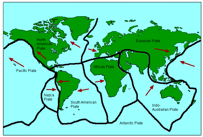 In 1912, Alfred Wegener and Frank Taylor first outlined the concept of continental drift, which proposed that the surface of the Earth is in motion albeit very slowly. At first the idea was considered preposterous by the scientific community but gradually gained acceptance as evidence in its favour accumulated. In the early 1960’s the theory of ‘sea-floor spreading’ was developed and gradually the idea that the Earth’s surface consists of a number of plates that move relative to each other gained acceptance and evolved into the theory of plate tectonics that we have today. However, there are some anomalies that the present theory does not explain so further revision is probably required.
These anomalies together with the geographical match between the two continents led to the formulation of the Expanding Earth Hypothesis(b).
When sea-floor spreading was identified in the Atlantic, some writers investigated where it might fit into the drama of Atlantis. It is not surprising that plate tectonics has been claimed by some, such as Frank Joseph, to support the existence of Atlantis, while others, including sceptic Paul Jordan, maintain that it makes the existence of Atlantis in the Atlantic an impossibility.
A further sceptical view of Atlantis in the Atlantic, by Benjamin Radford, claims(k) that “plate tectonics demonstrate that Atlantis is impossible; as the continents have drifted, the seafloor has spread over time, not contracted. There would simply be no place for Atlantis to sink into. As Ken Feder notes, ‘The geology is clear; there could have been no large land surface that then sank in the area where Plato places Atlantis. Together, modern archaeology and geology provide an unambiguous verdict: There was no Atlantic continent; there was no great civilization called Atlantis.'” This, of course, is perfectly true, except that Plato placed Atlantis in the Atlantic Sea, which many believe was a reference at that particular time to the Western Mediterranean!
An interesting website on the subject of the problems associated with the theory of plate tectonics by David Pratt is worth a read(a)(d)(i).>N.C. Smoot has also written(p) about anomalies encountered with the conventional theory of plate tectonics and possible solutions.<
Equally critical is the opening chapter of Thomas J. Krupa’s book Biblical Flood, Noah’s Ark and the Star of David[1010]. Sustained opposition to the theory has found expression in the NCGT Journal(e)since 1996.
Robert Bauval has written a paper on the possible effect that plate tectonics may have had on the accuracy of the orientation of the Giza pyramids(m).
Marvin Herndon has proposed a new theory, which he has entitled ‘Whole-Earth Decompression Dynamics’; a subtle combination of plate tectonics and the Expanded Earth Hypothesis(g). The idea of subduction is also challenged by the New Pangaea Theory (NPT)(h).
The starting point of NPT is that “252 million years ago our planet was impacted by a massive comet, a comet far larger than the one that wiped out the dinosaurs. This previous impact was so powerful it fractured the Earth’s crust, began the breakup of Pangaea and wiped out most of the life on the planet.”(o) The author, J. Chris Everett, proposes the comet, 100km in diameter, was absorbed into the body of our planet.
P.P. Flambas, author of Plato’s Caribbean Atlantis[1368] in which he has proposed a modification to the current theory of PT, which he has called the ‘Hydraulic Hypothesis’ to explain shortcomings in accepted PT theory and support his Atlantis location.
A July 2016 report was published on the rate of tectonic movement, estimated to be comparable to the speed of fingernail growth(f).
In 2020, it was reported that “scientists are beginning to understand the importance of another characteristic of any planet likely to support life, and it is one that fits squarely into (James) Lovelock’s view of Earth as a dynamic participant rather than a passive backdrop: an active system of drifting continents, otherwise known as plate tectonics. On the face of it, the connection between life, with its relatively brief cycles and dizzying complexity, and plate tectonics, with its much slower cycles and ostensibly simpler interactions, appears tenuous. But on Earth, at least, that connection is direct and deep.” (n).
Evidence of plate tectonics has now been identified on Mars(c)! In October 2019 NASA confirmed that a number of ‘marsquakes’ have been confirmed on the ‘Red Planet’(l). So far, the evidence suggests that our planet is more moon-like than earth-like.
(a) https://davidpratt.info/tecto.htm
(b) https://web.archive.org/web/20171105200137/https://www.grisda.org/origins/15053.htm
(c) https://www.sciencedaily.com/releases/2012/08/120809155831.htm
(d) https://www.thunderbolts.info/wp/2012/11/27/serious-issues-with-plate-tectonics-2/
(e) http://www.ncgtjournal.com/index.html
(g) http://www.nuclearplanet.com/510090.pdf
(h) https://web.archive.org/web/20170429173617/https://newpangaeatheory.com/the-enigmas/
(i) An Alternative to Plate and Expansion Tectonics – Thunderbolts Forum (v2.0) (archive.org) (new link) *
(j) https://www.researchgate.net/publication/238388608_Francis_Bacon_and_Continental_Drift
(k) https://www.livescience.com/23217-lost-city-of-atlantis.html
(l) https://www.universetoday.com/143625/insight-has-already-detected-21-marsquakes/
(m) http://www.robertbauval.co.uk/articles/articles/platetectonicsandgp.html
(n) https://nautil.us/why-aliens-and-volcanoes-go-together-1879/
(o) https://web.archive.org/web/20170429211143/https://newpangaeatheory.com/the-new-pangaea-theory/
(p) https://www.researchgate.net/publication/253098613_Earth_Geodynamic_Hypotheses_Updated *
Ortelius, Abraham
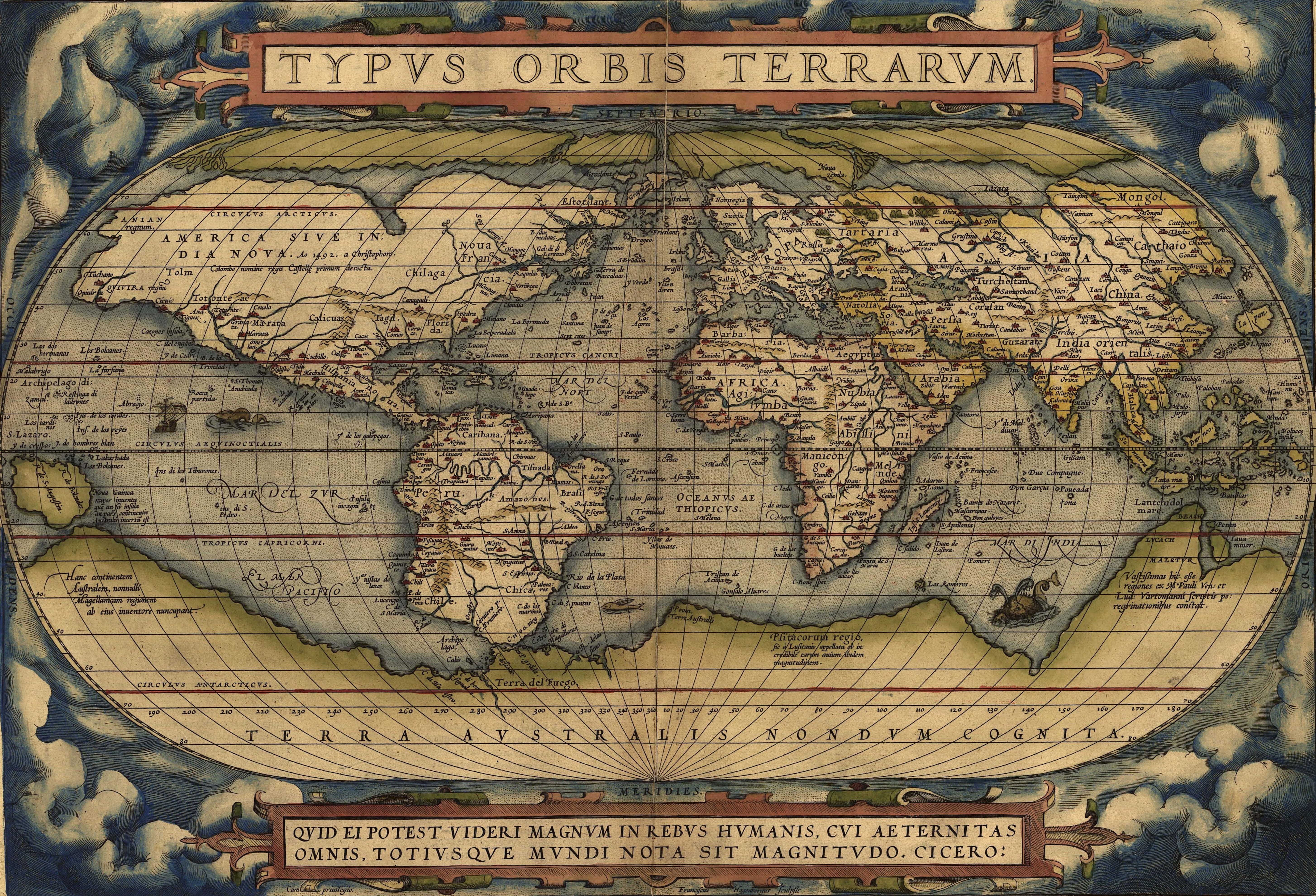
 Abraham Ortelius (1527-1598) was a Flemish cartographer who produced the first modern atlas, Theatrum Orbis Terrarum[1226], which at the time was reputed to have been the most expensive book ever printed.
It is interesting that he included the mythical island of Hi-Brasil (Brasil) off the coast of Ireland as well as the equally mysterious Frisland (Frieslant). Both can be clearly seen on his map using the link below(a).
In 1596 Ortelius was struck by the possibility that America, Europe and Africa had at one time been joined together but had over time become separated, an idea expressed in his Thesaurus Geographicus[1225]. Ortelius also included a speculative southern landmass, Terra Australis, which he designated as a “land of parrots”.
In 1597, Ortelius was the first to map(d) the travels of Homer’s Odysseus, notably locating all his adventures in the Central and Eastern Mediterranean, which was probably just a reflection of the limits of Greek maritime knowledge at the time that the narrative originated!
Ortelius suggested that Atlantis had been located in North America but that they had separated in the very distant past! Before modern theories of Continental Drift and its successor, Plate Tectonics, the idea of landbridges between continents was popular as an explanation for the spread of animals and people around the world. Some suggested as an alternative, the existence of lost continents such as Atlantis in the Atlantic, which acted as a stepping-stone between the continents(c).
Four hundred years later Alfred Wegener incorporated some of Ortelius’ ideas into his theory of Continental Drift, which later led to the current theory of Plate Tectonics.
A purpose-built polar exploration ship, m.v. Ortelius, was named after the geographer.
Recently, Doug Fisher has drawn attention to the similarities between a 1592 map of South America by Ortelius and the well-known Kircher map of Atlantis(b).
(a) https://upload.wikimedia.org/wikipedia/commons/e/e2/OrteliusWorldMap1570.jpg
(b) https://atlantismaps.com/chapter_7.html (link broken Oct. 2018) New website in development. (https://www.copheetheory.com/)
(c) Wayback Machine (archive.org) *
(d) https://www.laphamsquarterly.org/roundtable/geography-odyssey