Latest News

Joining The Dots
I have now published my new book, Joining The Dots, which offers a fresh look at the Atlantis mystery. I have addressed the critical questions of when, where and who, using Plato’s own words, tempered with some critical thinking and a modicum of common sense.Read More »
Sargasso Sea
Selwyn-Brown, Arthur
Arthur Selwyn-Brown was a physician and an author, best known for The Physician Throughout the Ages. In 1925, Dr. Brown wrote an article in the New York Herald, which was relayed around the world(a) in which he supported the Sargasso-Atlantis theory, an idea that had gained some support at the time.
Beebe, William
 William Beebe (1877-1962) was an American naturalist who carried out an extensive study of the Sargasso Sea in the 1920s. It was reported(a) that he had located Atlantis there, but I’m fairly certain that this was just journalistic exaggeration.
Mijatovich, Chedomille *
Chedomille Mijatovich (1842-1932) was a Serbian politician, economist and historian. He was one of the first in modern times to suggest that the Sargasso Sea may have been the maritime hazard described by Plato as a ‘shoal of mud’, which resulted from the submergence of Atlantis. This idea was conveyed to and recorded by Hyde Clarke(a).
(a) https://www.forgottenbooks.org/readbook/Transactions_of_the_Royal_Historical_Society_v3_1000379094#21 (p.14) (link broken) *
Gaffarel, Paul
 Paul Gaffarel (1843-1920) was a French historian who in his 1869 work, Rapports de l’Amérique et de l’Ancien Continent [1435], supported an Atlantic location for Atlantis(b). More specifically, he speculated that Atlantis might be found under the Sargasso Sea!
He believed that the influence of Atlantis could be detected in the Americas, Egypt and the Canaries.
In a later book, Histoire de la découverte de l’Amérique [1436], he recorded a belief among the native Caribs of the southern Caribbean islands that the Antillies were once a single landmass, with a similar tradition found in Haiti.
Paul Gaffarel wrote a number of papers between 1875 and 1890 on pre-Columbian trans-Atlantic voyagers from Europe. He presented a 38-page paper on the Phoenicians’ voyages to America to the Congrès International des Américanistes in Nancy (France) in 1875. Other essays concerned the Vikings and ancient Irish(a).
(a) Paul Gaffarel – Atlantisforschung.de (atlantisforschung-de.translate.goog)
Honorius Augustodunensis
Honorius Augustodunensis (fl.1107-1140) was a popular German theologian and a prolific writer. The Catholic Encyclopaedia quotes the view that Honorius was one of the most mysterious personages in all the medieval period. In what is arguably his best known work, Imago Mundi(c), he expressed the view that Atlantis had been an island in the Atlantic (35. Sardinia). He wrote that the ‘curdled sea’, assumed by Andrew Collins to be a reference to the Sargasso Sea[0072.91], “adjoins the Hesperides and covers the site of lost Atlantis, which lay west from Gibraltar.”
His Imago Mundi contained a world map, which has become known as The Sawley Map(b).
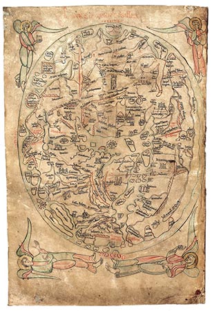
The Sawley Map
(c) https://12koerbe.de/arche/imago.htm
Spedicato, Emilio
Emilio Spedicato (1945- ) was born in Milan. He graduated in physics and is now working in numerical analysis and applied mathematics. He has held a full professorship at Bergamo University since 1984. In addition to his more conventional academic  pursuits, he also researches ‘non-standard models of planetary evolution and non-standard interpretation of myth and ancient religions.’
Spedicato has developed a list(a) of ‘54 theses for reconstructing Earth and human history during the catastrophic period 9500 to 700 BC’(l). This list is partly based on the work of Velikovsky, DeGrazia and Ackerman and is intended to be the basis of a larger work in book form. Some of his ideas will be seen as highly controversial such as the genetic manipulation of humans by extraterrestrial visitors. He locates the Garden of Eden and the ‘creation’ of Adam and Eve in the Hunza valley of modern Pakistan(e).
He ventured into further controversial territory with his support for an updated version of Hörbiger’s moon capture theory(f) and endorsement for pole shifts(g)(0) after long periods of stability following encounters with large extraterrestrial bodies. He considers the last of these to have taken place in the 10th millennium BC.
Spedicato, in a series of papers delivered to the Atlantis Conference on Melos in 2005, linked the biblical Exodus with the Flood of Deucalion, which he dates as 1447 BC(d). He contended that these events were connected with the explosion of a large extraterrestrial body over Southern Denmark remembered in Greek tradition as Phaëton. He also claims that a large object impacted or exploded over the Great Lakes ice cover around 10.900 BC(k).
Atlantis has not escaped Spedicato’s attention and he has put forward the Caribbean island of Hispaniola as the home of Atlantis(b), specifically suggesting that Lake Enriquillo in the Cul-de-Sac Depression, which runs from Haiti across the border into the Dominican Republic. Spedicato accepts the possibility of the destruction of Atlantis around 9600 BC and has written an interesting paper(c) that links the demise of Atlantis with a direct asteroidal impact or a close encounter with a planet-sized body. Not without significance is the fact that Hispaniola is not submerged, in spite of the sea level rising hundreds of feet since the very early date proposed by Spedicato for the destruction of Atlantis, which should have sent it even deeper beneath the waves of the Caribbean.
In his paper entitled Was Atlantis in Hispaniola? Arguments in Favour(n) he outlines his belief that “the Atlantis civilisation developed during the terminal phase of the last great glaciation. It was terminated by a catastrophe, of extraterrestrial origin, which led to the now confirmed fast melting of most ices covering North America (north of a line from Seattle to Washington) and northern Europe; this event is now rather precisely dated at circa 9500 BC. He also considers Plato’s ‘muddy shoals’ to be a reference to the Sargasso Sea.
Furthermore, leaving aside the question of submergence altogether, Spedicato does not explain how an Atlantis in the Caribbean could, in 9600 BC, have attacked Greece or Egypt, which did not exist as structured societies at that time.
Even more intriguing is why they would plan such a venture, considering a distance of 10,000 kilometres lay between them.
Spedicato has contributed at least a dozen papers to the Migration and Diffusion website including one on a possible Indian inspiration behind the Giza pyramid complex(h) as well as a paper(i) on the planet known to the Sumerians as Nibiru and today sometimes referred to as Planet X. He controversially claims that a close encounter with Nibiru around 9500 BC ended the last Ice Age and brought about the demise of Atlantis! A difficulty with that idea, is that if the encounter with Nibiru destroyed Atlantis AND ended the Ice Age how could the location where Atlantis was submerged still be marked by mud shoals 9,000 years later when sea levels had risen by 300-400 feet, as confirmed by Plato in Timeaus 25d?
Another radical idea put forward by Spedicato was expressed in a paper delivered to the 2005 Atlantis Conference [629.411], in which he claimed that what he called ‘the ancestors of the Greeks’ had visited Canada. Based on his interpretation of excerpts from the writings of Plutarch, he specifies a region at the mouth of the St. Lawrence River as the point of contact. Manolis Koutlis goes further, suggesting that the Greeks had colonies there, from 1500 BC until 1500 AD. Then in his book In the Shadow [1617] he adds the even more extraordinary claim that Atlantis had been situated on an island at the entrance to the St. Lawrence!
In 2010, Spedicato published Atlantide e L’Esodo (Atlantis and Exodus) which is currently being translated into English.
In February 2015, Spedicato published another paper(j) with the radical proposal that the alignment of the three main Giza pyramids was not intended to be a reflection of the three stars in Orion’s belt according to the Orion Correlation Theory (OCT), as proposed by Gilbert & Bauval[326], but instead were more closely matched to the arrangement of three volcanoes on Mars! He claims that these volcanoes were visible from Earth during Mars periodic close encounters with our planet between 7000 BC and 700 BC, during a 54-year cycle. However, Andrew Collins has also disputed the OCT and has instead offered evidence that the alignment of the three principal Giza pyramids matches more closely the ‘wing’ stars of the Cygnus constellation than the ‘belt’ of Orion! (m).
Later in 2015, the prolific Spedicato published another paper(k) in which he linked Mayan catastrophes with those of Hesiod, Plato and the Bible.
In late 2023, Spedicato, with assistance from Stuart Harris, published a two-part article(p)(q) concerning the location, dimensions and date of the Tower of Babel. Part One focuses on a possible connection between the dimensions of the Great Pyramid of Giza with that of the Tower of Babel. With regard to the comfusion of language associated with the Tower, Spedicato speculates that “construction works were stopped after a sudden strong magnetic field, due possibly to a close passage by Mercury, damaged the brain areas associated to the aquirement of new languages.“
(a) http://www.cartesio-episteme.net/ep8/ep8-spedic.htm
(b) https://www.academia.edu/10973532/ATLANTIS_IN_HISPANIOLA
(c) Wayback Machine (archive.org)
(d) https://www.2008-paris-conference.org/mapage13/deucalione-testo-inglese-1-.pdf
(f) https://aisberg.unibg.it/bitstream/10446/316/1/WPMateRi05(2008)SpedicatoPetruzzi.pdf
(g) https://www.unibg.it/dati/bacheca/63/21825.pdf
(h) https://www.migration-diffusion.info/article.php?id=353
(i) https://www.migration-diffusion.info/article.php?id=351
(j) https://www.migration-diffusion.info/article.php?year=2015&id=453
(m) (99+) (PDF) Orion: The Eternal Rise of the Sky Hunter | Andrew Collins – Academia.edu
Sargasso Sea
The Sargasso Sea is a region of the North Atlantic surrounded by ocean currents. Its limits are roughly 70-40° W and 25-35° N. It has a number of remarkable features, (i) it is very salty, (ii) it contains masses of seaweed of the genus ‘Sargassum’, giving the region  its name, and (iii) it is the place where the European eel migrates to, in order lay their eggs. The spawning habits of the European eel are indeed a mystery!
Wikipedia notes(b) that “The Sargasso Sea may have been known to earlier mariners, as a poem by the late 4th-century author Rufus Festus Avienus describes a portion of the Atlantic as being covered with seaweed, citing a now-lost account by the 5th-century BC Carthaginian Himilco the Navigator.” This early reference is used by supporters of the idea of the possibility of very early visits by Phoenicians or Greeks to America.
Chedomille Mijatovich, the Serbian politician, was probably one of the first to associate the Sargasso Sea with Plato’s ‘shoal of mud’ in a letter to Hyde Clarke.
In 2000, Andrew Collins in an effort to justify his Cuban location for Atlantis needed to find Plato’s ‘shoals of mud’ in the Atlantic and for me, in what seems to have been an act of desperation he decided that the Sargasso Sea fitted the bill [072.42]. Emilio Spedicato, promoting Hispaniola as Atlantis, also opted for the Sargasso as the ‘shoals of mud’. However, nobody has explained how anyone can mistake seaweed for mud!
In 1925, Dr A. Selwyn Brown wrote an article in the New York Herald, which was relayed around the world(a) in which he supported the Sargasso Atlantis theory. Around the same period the American naturalist, William Beebe, following an intensive study of the Sargasso was also reported(b) to have subscribed to the idea of the Sargasso as the location of Atlantis.
>>According to E.F. Berlioux, Paul Gaffarel speculated that Atlantis might be found under the Sargasso Sea.<<
It is obvious that the Sargasso Sea is centred to the west of the Mid-Atlantic Ridge and not over it as implied by some writers, particularly those who want to link it with an Atlantis situated on the MAR. Clearly, Plato’s account of the aftermath of the sinking of Atlantis describes impassable waters due to mud, not seaweed. Contrary to popular belief the Sargasso Sea is not a hindrance to navigation, however, for those under sail, a lack of wind presents a bigger problem.
(c) https://en.wikipedia.org/wiki/Theory_of_Phoenician_discovery_of_the_Americas
Cerne
Cerne was an island mentioned in the Pseudo-Scylax as being twelve days’ sail from the Pillars of Heracles. It adds that parts beyond the Isle of Cerne (Kerne) are no longer navigable because of shoals, mud and seaweed. Although some have seen this as a reference to the Sargasso Sea, mud and shoals are not characteristics of the Sargasso, which is a mile or more deep.
Diodorus Siculus (iii.54) wrote of the Amazons fighting the Atlantoi in the city of Cerne. Some commentators have identified Cerne with the islands of Kerkenna off the east coast of Tunisia, where, on the other hand, Egerton Sykes linked the Cerne referred to in Pseudo-Scylax with Lixus on the Atlantic coast of Morocco.
Frank Joseph erroneously claims[108.117] that the only known ‘Cerne’ was Cerne Abbas in England, the site of the famous naked giant carved into the chalk. There is certainly no suggestion of any Amazon invasion there and the physique of the giant was certainly never matched by even the most butch Amazons. Not for the first time, Joseph is blatantly wrong. As in the case of so many other places mentioned in connection with the Atlantis story there were a number of ancient towns named Cerne. The most famous such reference is in the record of Hanno’s voyage(b), generally accepted to be along the Atlantic coast of Morocco, where south of Lixus, he settled and named an island Cerne(a).
(a) https://www.ancient.eu/article/913/hanno-carthaginian-explorer/
(b) http://web.archive.org/web/20050305092920/http://www.metrum.org/mapping/hanno.htm See map
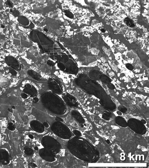
Carolina Bays
The Carolina Bays are named after the bay trees found growing in many of the 500,000 mysterious oval-shaped depressions, principally located in the eastern states of North America. In Maryland, the bays are called Maryland basins. In Mississippi and Alabama, they’re called Grady Ponds. In Kansas and Nebraska, they’re called Rainwater basins. In Texas, they’re called Salinas (because they often contain salty water).
Michael Tuomey (1805-1857) was the Irish-born State Geologist of South Carolina (1844-1847) and first State Geologist of Alabama (1848-1857). He is credited with being the first to note the distinctive geomorphic features of the bays, in a 1848 Report on the Geology of South Carolina (aa).
Allan & Delair have pointed out[014.254] in reference to the time of their creation, “the Carolina bays of the eastern United States, the smaller but otherwise closely similar ‘bays’ of Holland, and the aligned ‘lakes’ of north-eastern Siberia, Alaska, northern Yukon and north-eastern Bolivia were apparently produced then.”
Their characteristics have been presented as evidence of impact damage from a comet or asteroid. As early as 1933, Edna Muldrow published a seven-page article in Harper’s Monthly(r) putting forward the idea of a comet colliding with our planet and creating the ‘Bays’. This was probably inspired by a paper by geology professor Frank A. Melton and physics professor William Schiever, presented at the 1932 Annual Conference of the Geological Society of America(s).
This view is hotly disputed, as is the idea that they are of relatively recent origin at the beginning of the Holocene. Emilio Spedicato is one proponent who considers that a relatively recent impact to have been a contributory factor in the ending of the last Ice Age leading to the demise of Atlantis.
In 1976, Otto Muck was probably the first to suggest a link between the Carolina bays and Atlantis [098.154-158].
A more mundane explanation has been recently offered by Jon Pelletier, assistant professor of geosciences, at the University of Arizona in Tucson. He has just published a paper on a series of uniformly shaped and oriented lakes on the North Slope of Alaska. Pelletier has offered a credible ‘thaw slumping’ rationalisation for their annual growth. However, I have not seen his explanation for their existence in the first place. Pelletier’s explanation(a) for the Carolinas, is based on the dissolving of the underlying limestone, in a manner that generated lakes with a uniform orientation. In 2005, he conceded that his solution was ‘very speculative’.
In 1997, George A. Howard concluded a paper(x) on the Bays, with the following, “Given a confident belief that the answers are indeed out there in the sand, we come then to the true shame of the Carolina Bay story: the willingness of the current geophysical research community to tolerate and admit such a profound “mystery” in their midst. I’ve known respected professional earth scientists to brush off questions about Carolina Bays origin with references to “alien landings” and “giant fish.” With prodding, they generally elicit a thin collage of wind and wave theory faintly recalled from their student years. One gets the distinct feeling that the study of Carolina Bay origin is the ‘crazy aunt in the attic’ of the Coastal Plain researcher. And that visiting his dear relative is hardly worth the disturbing consequences.”
The cometary explanation was given additional support in 2007, when a team of researchers from Oregon University, outlined evidence that included the Carolinas, for the disintegration of a comet over Eastern Canada, around 10900 BC. They claim, that apart from the initiation of the Younger Dryas period, it caused widespread destruction across North America and also led to the disappearance of the Clovis culture. Further evidence supporting this view(b) was advanced by other academics in 2008.
A paper by Jennifer Marion, completely denies that there was any Holocene Impact that “caused a significant abrupt climate change, extinction event, and termination of the Clovis culture at 12.9 ka.” (v)
Nevertheless, there is also evidence from optically stimulated luminescence (OSL) dating, that the bays were formed 80,000 -100,000 years BP, which conflicts with the YD date! My layman’s view, is that after 80,000 years I would expect the bays to be much more eroded than they appear to be.
A more recent paper(e) by Antonio Zamora, offers an important new concept, namely that the ‘bays’ were created by a meteorite striking the Laurentide Ice Sheet, that existed in the Great Lakes region, during the last Ice Age, which in turn produced an enormous hail of ice ejecta, which rained down on the eastern seaboard, of what is now the United States. In his conclusion, he claims “that the new model of slow-velocity impacts from ice ejecta, resulting from a meteorite impact on the Laurentide ice sheet explains many of the characteristics of the Carolina Bays, including the lack of shock metamorphism and meteorite fragments.” Zamora has also published an impressive LiDAR image of a section of the bays, which is best viewed on a large screen(o).
Zamora has also published in 2012 an ebook entitled Meteorite Cluster Impacts [1120](f), and in his 2015 book, Solving the Mystery of the Carolina Bays [1121], he expands on his theory that the ‘Bays’ were created as a result of an extraterrestrial impact with the Laurentide Ice Sheet. He describes in great detail the mathematical basis for his views.
Zamora has now had a new paper on the ‘Bays’ published in the peer-reviewed journal, Geomorphology(i), which may help to rekindle discussion on the subject. Although, in my opinion, they are not directly related to the Atlantis narrative, the existence of the Carolina Bays provides very obvious evidence of our catastrophic past.
Ralph Ellis believes that Zamora’s ‘blocks of ice’ ejecta created by the impact, should be thought of instead, as being more akin to softer ‘slushballs’(g)(h). Ellis noted that the inspiration for his papers relating to the Bays came from the work of geologist Michael Davias(t). Davias and his friend Tim Harris, have been advocating the idea that Michigan’s Saginaw Bay holds evidence of an impact(u).
Robert W. Felix, an American architect, totally rejects the ice ejecta theory, principally because the Laurentide Ice Sheet (LIS) should have disappeared before the creation of the Carolina Bays(l). However, conventional wisdom dates the decline of the LIS to around 9,600 BC(m), coincidental with the arrival of the Carolina Bats! Felix contends in one of his books [1688] that the Bays were formed by millions of gigantic explosions in the sky, explosions triggered by a magnetic reversal!
The serial sceptic, Paul Heinrich, claims(d) that there is dating evidence, which indicates varying dates for the creation of different Carolina Bays. The most recent popular work to discuss comprehensively, the origin as well as the conflicting dating evidence for the Carolinas, is The Cycle of Cosmic Catastrophes by Firestone, West and Warwick-Smith. This is an important book that is primarily concerned with a cosmic catastrophe that wiped out the North American mammoth along with other large animals, at the same time that the Clovis People disappeared 13,000 years ago. This was also the time of the colder Younger Dryas period.

When the Russian investigator Leonard Kulik studied the Tunguska River area, over which a meteor/asteroid exploded in 1908, he discovered several neat oval bog holes that might offer support for either the impact theory, or the more improbable theories of Pelletier.
Now, over a century after the Tunguska event, an Italian research team has concluded it was an asteroid which struck the earth and nearby Lake Cheko is the impact crater(c). However, this theory was debunked in 2017, by “researchers led by Denis Rogozin, from the Institute of Biophysics at the Siberian Branch of the Russian Academy of Sciences, carried out their own analysis and concluded that lake sediments were at least 280 to 390 years old, ‘significantly older than the 1908 Tunguska Event.’
And in a new study published May 2 in the journal Doklady Earth Sciences, Rogozin and colleagues presented more evidence to refute the idea Lake Cheko is the Tunguska asteroid’s impact site.”(z)
In 2013 Gernot Spielvogel co-authored Sonnenbomben[1582] in which it is suggested that the Tunguska event was caused by a solar plasma ‘bomb’! Even Nikola Tesla was blamed by some, as the perpetrator of the Tunguska event(n).
However, although the impact theory does appear to have widespread support, there appears to be a move to look at a natural earthbound explanation. The U.S. Geological Survey is now identifying the Bays as, ‘relict thermokarst lakes’(q).
Such suggestions have been excluded by Paul-Jürgen Hahn who is adamant that the bays were the result of a cometary impact with the Sargasso Sea and was also linked to the Atlantis story and the Pyramids and Sphinx! He gives the date of the impact as “12 March 9,337 BC (Greg.), 10:19 true local time in South Carolina, respectively 09:27 Bahamas time.”(y)
A 2020 article, reviews the theories relating to the origin of the bays, as well as the extraordinary biodiversity to be found within the bays(p).
Nevertheless, various other theories are still under investigation, including serious consideration of the possibility of an alien spaceship explosion!(j)
Charles O’Dale, a Canadian researcher who has studied impact craters across Canada, also ventured south to investigate the Carolina Bays. In a 2022 paper, he includes a number of excerpts, from a range of other commentators, that highlight the principal details relating to the Bays, that are still in contention ninety years after their first discovery(w).
In 2024, David Anderson, a retired physician, offered another look at the mystery of the Carolina Bays and their creation at the time of the Younger Dryas. In a 2024 paper(ab) on Graham Hancock’s website, he reviewed the work of Zamora and Firestone et al and concluded that both offered valuable information, but that some modification was required. However, Anderson saw the catastrophe that created the Bays in a global context, which resulted in his detailed study of the origins of the Hongshan Shui Jing glass and offers evidence to associate them with the Younger Dryas event. He digresses near the end, with a suggestion on how the large stones used by megalith builders were moved, which he proposed was done using balloons filled with hydrogen or methane!
(a) See: Archive 2042
(c) https://phys.org/news/2012-05-team-evidence-lake-cheko-impact.html
(d) https://web.archive.org/web/20230401113847/http://atlantipedia.ie/samples/archive-2040/
(e) https://www.scientificpsychic.com/etc/carolina-bays/carolina-bays.html
(g) https://independent.academia.edu/ralphellis4 see (h)
(i) https://www.sciencedirect.com/science/article/pii/S0169555X16308479?np=y (abstract only)
(j) https://www.qconference-athens-2011.grazian-archive.com/aspacekeytotheri/rubtsov-paperx.pdf
(k) https://en.wikipedia.org/wiki/Carolina_bay
(l) Carpet bombing the Carolinas – Ice Age Now (archive.org)
(m) https://study.com/academy/lesson/laurentide-ice-sheet-facts-collapse-timeline.html
(n) https://theunredacted.com/the-tunguska-blast-teslas-death-ray/
(o) https://www.scientificpsychic.com/etc/carolina-bays/carolina-bays-image.html
(p) https://augustamagazine.com/2020/06/30/amazing-carolina-bays/
(q) https://earthobservatory.nasa.gov/images/147904/ice-age-carolinas
(r) The Comet that Struck the Carolinas Harper’s Monthly No.168, 1933. p 87
(s) https://www.jstor.org/stable/30084930
(t) http://cintos.org/index.html
(v) (99+) Arguments and Evidence Against a Younger Dryas Impact Event | Jennifer Marlon – Academia.edu
(w) https://craterexplorer.ca/carolina-bays-structure/
(x) The Carolina Bays: George Howard’s Original 1997 Web Essay « The Cosmic Tusk (archive.org) *
(y) Die Datierung der Atlantis-Katastrophe (p-j-hahn.de)
(z) The biggest asteroid to hit Earth in recorded history vanished without a trace: How? | Live Science
(aa) https://archive.org/details/reportongeologyo00tuom/page/144/mode/2up [p.143-144]
Eel Enigma *
The Eel Enigma was first noted by the Danish biologist Johannes Schmidt (1877-1933) at the beginning of the 20th century. The American eel spawns in the western part of the Sargasso Sea and their European relatives in the eastern sector. When the larvae hatch, the European eels are carried on the Gulf Stream towards Europe; a trip that takes about three years. The survivors of this long journey split up when they reach the shores of Europe. The males remain at sea and the females swim up the rivers and remain there for two years. They then rejoin the males and return together to the Sargasso where they mate, after a short journey of only one hundred and forty days.
A number of investigators, such as Otto Muck, have cited this mystery of nature as the result of the eels ’remembering’ a former landmass in the middle of the Atlantic. These writers have equated this landmass with Atlantis. However, a landmass is not what the eels require but the protective cover provided by the seaweed of the Sargasso while mating. I find it hard to accept this eel theory, although many find it credible. Perhaps millions of years ago before the tectonic plates had separated the European and American continents as far as they are today, the eels had originally only a short distance to travel. Over the ages, the journey became longer until it is now close to the physical limitations of the creatures.
A similar observation was made by Henry Eichner who pointed out the existence of shellfish in the Sargasso which is normally found in shallow waters along shorelines. Eichner suggested that this adaptation by the shellfish may be evidence for the existence of an earlier shoreline now lost through inundation!
More recently, Daniel Schwamm added a related claim in a 2012 paper – “There are many animals that are guided by a primal instinct to find their way to where Atlantis is said to have once been. For example, the lobsters of the Azores move unerringly to the west, deeper and deeper into the sea, as if they expected a rise in the seabed there sooner or later.”(b)
Equally intriguing but unconnected to any Atlantis claim is the migratory path of monarch butterflies(a).
(a) Butterflies remember a mountain that hasn’t existed for millennia (archive.org) *
(b) http://www.daniel-schwamm.de/index.php?pg=texte/atlantis.htm