Latest News

Joining The Dots
I have now published my new book, Joining The Dots, which offers a fresh look at the Atlantis mystery. I have addressed the critical questions of when, where and who, using Plato’s own words, tempered with some critical thinking and a modicum of common sense.Read More »
Cerne
Red Sea
The Red Sea, also known as the Erythraean Sea lies between Egypt and Sudan in Africa and Saudi Arabia and Yemen in Asia.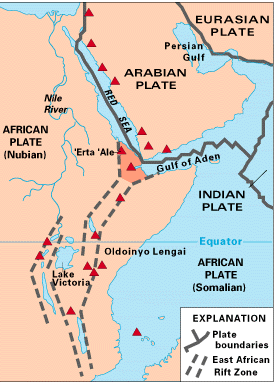 At the southern end lies the strait of Bab-el-Mandeb, considered by a few researchers as the location of the Pillars of Herakles.
Pliny the Elder refers to ‘Pillars’ at the end of the Red Sea and then, without pause, inexplicably mentions, Mauritania, Mt. Atlas and Cerne and shortly afterward to an island known as Atlantis!(c)
The Red Sea has entered the Atlantis debate mainly because the biblical Exodus has been linked with the 2nd millennium BC eruption of Thera and in turn to the Minoan Hypothesis. Unfortunately, a variety of dates are on offer for the time of the Exodus, which failed to help us pinpoint the date of the eruption or enable the Minoan Hypothesis to provide a definitive date for the destruction of Atlantis.
For many, the Red Sea is associated with the biblical Exodus. However, the term used to describe it in the Hebrew text is ‘yam suph’, which does not mean Red Sea but ‘Sea of Reeds’ that left generations of bible students looking in the wrong place for evidence of the Exodus. Even the ‘Sea of Reeds’ explanation has been disputed in a paper by Bernard F. Batto on the Biblical Archaeology website(h). Consequently, researchers have turned their attention to other possible location.
One example is a paper offered by Gary Byers who concluded that today’s Ballah Lake in the northeast Nile is the Exodus crossing point! However, the search is not over.
The ‘Red’ is often attributed to the seasonal blooming of a red-coloured bacterium. Some academics think that the cardinal points were ascribed colours, ‘red’ being south! Emilio Spedicato, in his paper(a) on the location of the biblical Ophir, points out that pumice which is normal volcanic ejecta turns blood-red when mixed with seawater. Immediately to the south is the East Africa Rift, home to dozens of volcanoes, which when erupting may have had pumice dust blown towards the Red Sea!
Coincidentally, the presumed cradle of humanity is situated not too far from the Rift volcanoes and has drawn serious claims(b) that they may have had a part to play in the evolution of hominids!
The oldest known map of the Red Sea, referred to as the Nuzi Map has had its origins traced back to 120 years before the Flood of Noah(d)! George & Dana Brown, a father and son team from Florida, refer to the Red Sea as the Edenic Valley, to the east of which, in northwest Saudi Arabia, Cain’s city of Chanoch had lain and also where, according to the Browns, Noah’s Ark landed(f)!
(a) https://2010-q-conference.com/ophir/ophir-27-10-09.pdf
(b) https://www.seeker.com/volcanic-eruptions-led-to-emergence-of-first-humans-2052178636.html
(d) http://web.archive.org/web/20240413034120/https://www.angelfire.com/fl/BriansHouse/nuzimap.html
(h) Red Sea or Reed Sea? – The BAS Library (biblicalarchaeology.org)
Cabriolu, Mario
Mario Cabriolu is a Sardinian, who actively supports the theory of Sergio Frau, which places Atlantis on Sardinia. He has published an illustrated paper on the sardolog.com website in support of that contention(a) with the bold title of Sardinia is Atlantis? He also wrote papers on Cerne(b) and Tartessos(c) on the same site.
(a) SardoLog – Sardegna è Atlantide? (archive.org) (Italian) *
(b) SardoLog – CERNE : l’isola-città colonia degli Atlanti (archive.org) (Italian) *
(c) SardoLog – Tartesso (archive.org) (Italian) *
Richat Structure, The
The Richat Structure or Guelb er Richat in Mauritania” is regarded by geologists as a highly symmetrical and deeply eroded geologic dome. It was first described in the 1930s to 1940s, as Richât Crater or Richât buttonhole. Richard-Molard (1948) considered it to be the result of a laccolithic thrust. A geological expedition to Mauritania led by Théodore Monod in 1952 recorded four ‘crateriform or circular irregularities” in the area.”(q)
The feature was thought by 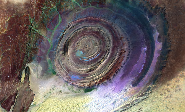 many to be an impact crater until it was identified as the remains of a possible ‘salt dome’(a). Some of the more enthusiastic supporters of the ‘Electric Universe’ school of thought have sought to identify the feature as the consequence of an electrical discharge.(e)
This is outlined in an April 2022 paper by Andrew Hall, explaining what he calls the ‘Keystone Pattern’.(r)
Even creationists have claimed that the original surface of the ‘Structure’ had been eroded by Noah’s Flood(t).
The concentric circles of which the structure is composed is clearly revealed by satellite imagery. However, these characteristics are not visible when walking across the structure(u). The scientific consensus today is that the structure is a natural geological feature. In more technical terms a geological ‘dome’ is “A structure that plunges in all directions to form a circular or elongate structure is a dome. Domes are generally formed from one main deformation event, or via diapirism from underlying magmatic intrusions or movements of upwardly mobile, mechanically ductile material such as rock salt (salt dome) and shale (shale diapir). The Richat Structure of the Sahara is considered a dome that has been laid bare by erosion.”(k) Further geological data was available on a German website(v).
It did not take long before it was compared to Plato’s description of Atlantis. However, Ulf Richter has pointed out that it is too wide (35 km), too elevated (400 metres) and too far from the sea (500 km) to be seriously considered the location of Atlantis. Nevertheless, researchers such as Robert deMelo are still prepared to consider it a possible location candidate(b).
50 km west-southwest of Richat is a similar though smaller feature, the Semsiyat Dome, having a diameter of just 5 km(o).
A 2023 geological study(z) of the Richat feature is worth a read.
In 2008, George Sarantitis put forward the idea that the Richat Structure was the location of Atlantis, supporting his contention with an intensive reappraisal of the translation of Plato’s text(g). His theory has been published in Greek[1470], with an English translation now (2017) imminent.
In 2006 George S. Alexander and Natalis Rosen were struck by the similarity of the Richat feature with Plato’s description and decided to investigate on the ground. Instability in the region prevented this until late 2008 when they visited the site, gathering material for a movie. The film was then finalised and published on their then-newly-established website in 2010(c).
In 2008, Charles Giuliani self-published Alternative View of The Distant Past [1969]. In this wide-ranging book, the author tackles the story of Atlantis and endeavours to identify the Richat Structure as the location of Plato’s city of Atlantis. His speculations lack scientific evidence and contradict reason. The main weaknesses are his dating of Atlantis (9600 BC) and the logistical problems of launching an attack on Athens 4,000km away from Richat at a time when archaeology indicates that seafaring was carried out with little more than dugout canoes or rafts.
In 2013 further support for linking Atlantis with Richat came from Jose D.C. Hernandez with a rather convoluted theory in a paper entitled A Celestial Impact and Atlantis(f).
Even more bizarre is the claim by Anthony Woods that although Ireland was the island of Atlantis, the city of Atlantis (Cerne) was in Mauritania and is known today as the Richat Structure!
Towards the end of the 2018 media ‘silly season’, the YouTube channel Bright Insight made a pathetic attempt to breathe new life into the Atlantis in Sahara theory. However, it fails on one simple fact; it is not submerged, but for good measure, when Alexander and Rosen investigated the Richat Structure they could not produce a single piece of physical evidence from the 35 km wide site. Where was the bustling port described by Plato? I could go on, but remember, it’s not called the silly season without reason.
Early November 2018 saw the British tabloid press give further coverage to Jimmy Corsetti’s ideas(i)(j) (The Sun gave his name as Jimmy Bright!). His theories are totally dependent on the destruction of Atlantis having occurred around twelve thousand years ago. He does not explain how an attack was launched from Mauritania on Athens which did not even exist at that time. Corsetti, like many others, needs this very early date to explain why the Richat Structure is not underwater today but was gradually uplifted as a result of tectonic forces in the region. However, Plato clearly states that the submerged Atlantis was still a hazard to shipping in his day, a period when the Structure would have been at its present elevation. As no geologic event has occurred during the two and a half millennia since Plato, which could have raised the Structure from the seabed to an elevation of 400 metres 500 km from the Atlantic, we are obliged to give greater credence to the scientific conclusion that the Richat Structure is a natural feature. Corsetti does have at least one fan(n).
It was in 2018 that Corsetti published a video promoting the Richat Structure as Atlantis, which received extensive coverage. Steven Novella, a well-known Atlantis sceptic, published an article debunking Corsetti’s ‘evidence’ in some considerable detail(s). However, while I would endorse Novella’s arguments(l) regarding the Richat Structure, I strongly disagree with Novella’s closed-minded attitude towards the existence of Atlantis as well as Corsetti’s attention-seeking location choice for Plato’s island. I would add that Corsetti has his date wrong and that to launch an attack on Athens nearly 4000 km away by land (3000 km by sea) from the ‘Structure’ is logistical nonsense.
In a recent conversation with Joe Rogan, Corsetti claimed that since the Structure contains salt, it MUST have been submerged and no other explanation is possible. However, as I have pointed out above the Richat feature is an eroded ‘salt dome’ and quite naturally has salt in it without the need for submersion.
The natural geological origins of the Richat Structure are discussed in some detail in a 2005 paper by three Canadian scientists in the journal Geology, produced by the Geological Society of America. It would be interesting to hear the response of Corsetti to facts compared with his daft speculations(w).
However, in 2018, Martin K. Ettington published a booklet entitled The Real Atlantis [1641] in which he also insisted that the Richat Structure is the remains of Atlantis but with no real evidence to support his contention.
In Joining the Dots [1590] and in Atlantipedia.ie I have consistently argued that in ancient times, proximity is an essential logistical requirement in order to achieve a successful invasion. This was particularly true in ancient times when all empires expanded through the invasion of neighbouring territories. The Richat Structure is many thousands of kilometres from Athens, so to suggest that an attack was launched from Mauretania on Greece is simply ludicrous.
There is a relatively recent website(m) dedicated to promoting the ‘Structure’ as the location of Atlantis. It is well presented by its author Gergely (Gregory) Dzsida with plenty of content. Unfortunately, I cannot accept its basic claim, To my mind, it fails to answer Richter’s arguments regarding, size, elevation and location as well as my point regarding proximity.
Not unexpectedly, Jason Colavito has a few thoughts to add to this latest Atlantis in Sahara kerfuffle(h).
Although the Richat Structure as the location of Atlantis conflicts with details in Plato’s account as well as reason, it still gathers supporters based simply on its circular shape. A recent example of this came from a Danish commentator, Palle A. Anderson(p).
An even more ridiculous suggestion was offered in 2021 by Carlos Bisceglia in Atlantis 2021- Lost Continent Rediscovered in which he proposed that Atlantis was known to the Egyptians as the ‘Land of Ma’ and that its capital was the Richat Structure together with the Semsiat Dome, mentioned above, which is 50km away. In order to explain how his Atlantis is not submerged, Bisceglia has proposed that the Land of Ma became confused with the submerged Land of Mu (Sundaland) in the Pacific and that “it is possible that Solon or Plato confused ‘the Land of Ma’ with the ‘Land of Mu’, and thus two completely independent accounts were merged into one.” He adds “how the Egyptian priests knew this is a mystery. Evidently, some survivors from Sundaland arrived in some way in Egypt”
In April 2022, David Edward published Atlantis Solved: The Final Definitive Proof [1926], which also endorsed the Richat Structure as the location of Atlantis. The author of this slender 99-page book admits to being greatly influenced by the earlier claims of Jimmy Corsetti.Edward was obviously unhappy with my comments, so he wrote to me complaining that I was costing him hundreds of books sales a day, a claim supported by as much evidence as there is for the Richat Atlantis(y) .
In a 2021 paper(x), Thorwald C. Franke listed a number of reasons why ‘Richat’ cannot be considered as the location of Atlantis. He did not present his selection as definitive but did claim that “our small list is already quite sufficient to establish that this hypothesis does not stand the slightest chance.”
Also in 2021, the prolific Shifu Careaga published a lengthy paper challenging Jimmy Corsetti’s Richat theory. At the start of the paper he offered the following reasons for rejecting Corsetti’s claims.
“Mr. Corsetti’s hypothesis is clearly and definitively incorrect for all of the following reasons:
- That region of Africa has not been submerged in over 99 million years4, and its uplift and downthrust values are stable
- At the time of the Younger Dryas, the sea level was lower and could not have made the richat area an island.
- The richat formation is not concentrically circular.
- It could never act as canals or hold water.
- It is itself on a tilt (and we will look at the topographics and satellite data on this)
- There are no mountains immediately to the north.
- The Atlas Mountains are named for King Atlas, who was named for Atlantis (perhaps), not vice versa.
- The regions is not 1000 miles past the Pillars of Heracles (straits of Gibraltar)
- The whale carcasses found are from clear fluvial megatsunami inundation, as Jimmy himself points out” (aa)
Although not all on Careaga’s list are show-stoppers, but, when combined with the fundamental objections noted above from Ulf Richter, the Atantis in Richat theory looks quite flimsy.
Another site expanded on the difficulties that the elevation of the Structure poses for Corsetti and Co, in the short excerpt below
The Elevation Problem:
The Richat Structure is actually elevated above the surrounding terrain, not in a depression. The structure sits at about 400 feet (120 meters) above sea level, with the plateau standing some 200 meters above the surrounding desert sands, and the peak of the outer rim reaching 485 meters above sea level. The central rings are about 80 meters (260 feet) tall.
This creates exactly the drainage problem you identified – water would flow OUT of the structure, not into it. The concentric rings are actually ridges of harder rock (quartzite) that stand higher than the valleys between them.
Why Water Flow Wouldn’t Work:
It’s a dome, not a basin – The sedimentary rocks dip outward at 10-20° , meaning water would naturally flow away from the center
No natural water retention – The “rings” are actually elevated ridges with valleys between them, but these valleys drain outward
Distance from water sources – At 500km from the Atlantic Ocean and sitting on an elevated plateau, there’s no natural way for ocean water to reach it
Limited catchment – Even during the humid Sahara period, the structure would shed water rather than collect it
The Reality for Ancient Water Access:
Archaeological evidence shows the area was used for short-term hunting and tool manufacturing, with sediments containing freshwater fossils from playa lakes between 15,000-8,000 years ago during the African humid period . But these were temporary seasonal lakes in the low areas, not a permanent water-based city.Any substantial water-based civilization here would have required massive engineering to: (1) Dam the outward-flowing valleys (2) Import water from distant sources or (3) Create artificial retention systems.
The natural topography actually works against water accumulation, which explains why no evidence of permanent large-scale habitation has been found in the structure itself.” (ac)
Caleb Howells began 2025 with a debunking of the claim that Atlantis had been situated in the Richat Structure in Mauritania(ab).
(a) https://web.archive.org/web/20160326200714/https://www.atlantis-schoppe.de/richter.pdf
(b) http://www.gpofr.com/documents/2012Atlantis.pdf
(c) Visiting Atlantis | Gateway to a lost world (archive.org)
(e) Earth’s Richat Crater (archive.org)
https://www.thunderbolts.info/tpod/2005/arch05/050407richat.htm
(f) https://blog.world-mysteries.com/science/a-celestial-impact-and-atlantis/
(g) The System of Wheels – Plato Project (archive.org)
(h) https://www.jasoncolavito.com/blog/youtube-video-claims-atlantis-is-located-in-the-sahara-desert
(i) https://www.thesun.co.uk/news/7681682/atlantis-sahara-desert-conspiracy/
(l) https://theness.com/neurologicablog/index.php/no-atlantis-has-not-been-discovered-in-north-africa/
(m) Learn from Ancient Civilizations | Find Atlantis Together (archive.org)
(o) Are the so-called impact craters in Mauritania kimberlite pipes ? (archive.org) (see the end of page)
(p) The Real Atlantis – where is it? (planker.dk)
(q) Richat Structure – Wikipedia
(r) The Keystone Pattern – The Thunderbolts Project™
(s) https://theness.com/neurologicablog/index.php/no-atlantis-has-not-been-discovered-in-north-africa/
(t) https://creation.com/eye-of-the-sahara
(v) richat description (archive.org)
(w) https://archipel.uqam.ca/272/1/Matton_etal05.pdf
(x) Against the 10,000 BC Belief Complex – Atlantis-Scout
(y) Private Correspondence.
(z) Eye Of The Sahara or Richat Structure » Geology Science
(aa) (PDF) Ashes of Atlantis – part 1 | Shifu Careaga – Academia.edu (archive.org)
(ab) https://greekreporter.com/2025/01/05/eye-sahara-lost-atlantis/
(ac) https://claude.ai/share/dcb21c98-40b4-422f-a168-986e6df6477b
Chaouat, Dr. Émile Mir
Dr. Émile Mir Chaouat follows the views of Butavand and agrees that Plato’s 9,000 years should be taken as months and consequently dates the destruction of Atlantis to 1400 BC. He agrees, in common with many other writers, that the Sahara once had a large inland sea which contained Atlantis. He believes that its Mediterranean port was located at Cerne. He points out that Athena and Neith, the goddess of Sais, were identical and suggests that the name of the legendary North African queen Tin Hanan may be a corruption of Athena [(A)tin-ha(nan)]. In 1925, Byron Khun de Prorok claimed to have found the tomb of Tin Hanan, renowned queen of the Tuaregs, in the Hoggar Mountains. Chaouat published his views in a 1953 booklet, Lumiére sur l’Atlantide [227].
Robert Charroux was intrigued by Chaouat’s book[1039.122].
However, Atlantisforschung tells us that “this was apparently only the first volume of a multi-part Atlantological publication series from his pen because WorldCat also contains references to three other related publications of his, namely: L’Atlantide. Deuxième partie (1957), L’Atlantide. 3. Lumière sur l’Atlantide, les Atlantes en Afrique, Libye des Anciens (1957) and Lumière sur l’Atlantide / 4, Les Atlantes en Europe (also 1957). Unfortunately, none of these works currently seems to be available in an antiquarian form, but they are at least still available in some university libraries.” (a)
(a) Émile Mir Chaouat – Atlantisforschung.de (atlantis-forschung.de)
Cerne
Cerne was an island mentioned in the Pseudo-Scylax as being twelve days’ sail from the Pillars of Heracles. It adds that parts beyond the Isle of Cerne (Kerne) are no longer navigable because of shoals, mud and seaweed. Although some have seen this as a reference to the Sargasso Sea, mud and shoals are not characteristics of the Sargasso, which is a mile or more deep.
Diodorus Siculus (iii.54) wrote of the Amazons fighting the Atlantoi in the city of Cerne. Some commentators have identified Cerne with the islands of Kerkenna off the east coast of Tunisia, where, on the other hand, Egerton Sykes linked the Cerne referred to in Pseudo-Scylax with Lixus on the Atlantic coast of Morocco.
Frank Joseph erroneously claims[108.117] that the only known ‘Cerne’ was Cerne Abbas in England, the site of the famous naked giant carved into the chalk. There is certainly no suggestion of any Amazon invasion there and the physique of the giant was certainly never matched by even the most butch Amazons. Not for the first time, Joseph is blatantly wrong. As in the case of so many other places mentioned in connection with the Atlantis story there were a number of ancient towns named Cerne. The most famous such reference is in the record of Hanno’s voyage(b), generally accepted to be along the Atlantic coast of Morocco, where south of Lixus, he settled and named an island Cerne(a).
(a) https://www.ancient.eu/article/913/hanno-carthaginian-explorer/
(b) http://web.archive.org/web/20050305092920/http://www.metrum.org/mapping/hanno.htm See map
Berlioux, Etienne Félix
Étienne Félix Berlioux (1828-1910) was a 19th century French professor of geography in Lyon. In an 1883 book he placed Atlantis on the Atlantic coast of Morocco between Agadir (a variant of Gades) and Casablanca[163]. According to Berlioux this location was the site of the city of Cerne the capital of the Atlantes referred to by Diodorus Siculus and Herodotus(c).
In 1907 he presented a series of papers entitled ‘Morocco and the Atlanteans’ for the Academy of Sciences at Lyons. Berlioux also wrote an account of the slave trade in Africa in the 1870’s[164].
Jonas Bergman places Atlantis further north near Rabat.
His book on Atlantis, in French, can be read online(a).>>The Introduction to which has been translated into English by Jason Colavito(b).<<
(a) https://archive.org/details/lesatlanteshist00berlgoog
(b) https://www.jasoncolavito.com/atlantis-in-morocco.html *
(c) Atlanteans in Africa: Herodotus and Dionysius Skytobrachion (arcus-atlantis.org.uk) *