Latest News

Joining The Dots
I have now published my new book, Joining The Dots, which offers a fresh look at the Atlantis mystery. I have addressed the critical questions of when, where and who, using Plato’s own words, tempered with some critical thinking and a modicum of common sense.Read More »
Sicilian landbridge
Sicily *
Sicily was known in earlier times as Trinacria because of its triangular shape. The island was first inhabited by modern humans during the last Ice Age(h) when lower sea levels exposed a land bridge between it and what is now mainland Italy.
Antoine Gigal, the French writer and explorer noted(f) that “In the Odyssey, Homer refers to Sicily as Sikania (in classical texts it is also called Sikelia) and mentions the Sicanian Mountains. This is why one of the three native peoples of Sicily was named the Sicani (Sikanoi or Sicanians). They were probably there from 3000-1600 BC, from the earlier proto-Sican period, where various Mediterranean influences reached the Neolithic population that was based more in the central and western part of the island.”
She added later “Some modern researchers think that Siculo and his people originated from even further away, from the east. Prof. Enrico Caltagirone and Prof. Alfredo Rizza have even calculated that in the modern Sicilian language there are more than 200 words that come directly from Sanskrit. Then from the Bronze Age and classical antiquity there is evidence of another Sicilian people, the Elymians, who migrated from Anatolia and may have been descended from the famous “Sea Peoples”. The west of Anatolia was then occupied by non Indo-Europeans. Thucydides said they were refugees from Troy.
Indeed a group of Trojans are supposed to have survived the defeat of Troy, having escaped by sea, and settled in Sicily and mixed with the Sicani. Virgil even writes that they were led by the hero Acestes, king of Segesta in Sicily, who gave help to Priam and Aeneas, and had Anchises buried in Erix (modern Erice).”
Plato was quite familiar with Sicily having paid a number of visits there(i) and on one occasion was sold as a slave having offended King Dionysius with his criticism of tyrannical rulers. Many think that his time in the capital, Syracuse, inspired elements of his description of the capital of Atlantis!
The island was probably first suggested as having a link with Atlantis by Mário Saa in a 1936 book in which he has Atlantis stretching from and including Sicily and the Maltese archipelago all the way to Tunisia. It was then more than four decades before Phyllis Young Forsyth wrote her book, Atlantis: The Making of Myth [266], in which she expressed her belief that Plato wrote the Atlantis story as an anti-war allegory partly based on his own experiences with the king of Syracuse.
More recently a number of other 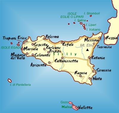 writers have also put Sicily forward as a location for Atlantis. One of these was Francesco Costarella, who is an Italian researcher and the author of two books relating to Atlantis. The first [1636] puts forward the idea that Plato’s Atlantis and the biblical Deluge, are in the author’s words, ‘two sides of the same coin’, while in the second [1637], he identifies Sicily as the location of Atlantis.
In the main, it has been European investigators who have advocated such a Sicilian connection and some have gone further and proposed a land bridge with Tunisia within the memory of man.
Dr Peter Jakubowski also offers(a) Sicily and the Malta Plateau as the location of Atlantis. He proposes a cosmic impact in the Atlantic which closed the Strait of Gibraltar around 4800 BC. When the dam eventually broke, the Mediterranean to the west of Sicily began to fill. This was then followed by the breaching of the land bridge between Sicily and Africa and finally, the dam in the Bosporus broke, flooding what was a much smaller Black Sea than we have today. Jakubowski’s site is apparently a reworking of Axel Hausmann’s book. A few years ago he revamped his website but removed all the Atlantis material.
Patrick Archer has also adopted the concept of a Sicilian land bridge and promotes the idea that the breaching of it and its consequences were the inspiration for the biblical Deluge(e).
Alberto Arecchi(b) has added his voice in support of this Sicilian land bridge linking Italy with Africa and places Atlantis off the coast of modern Tunisia.
Further support has come from Thomas J. Krupa in his 2014 book[1010], which proposes that the land bridge was composed of limestone which over time had been partially dissolved by rainwater and was under stress from the rising sea levels on its western side. He considers the land bridge the most likely location for Atlantis, which was destroyed when the isthmus was sundered by an earthquake.
Another exponent of a relatively recent collapse of the Gibraltar Dam is the previously mentioned Axel Hausmann[371] who locates Atlantis between Sicily and Malta.
Alfred E. Schmeck has written[542], in German, a detailed look at Sicily as the inspiration for Plato’s narrative.
Thorwald C. Franke has a well-balanced website(c), in German and English, supporting the idea of a Bronze Age Sicilian Atlantis. For topographical reasons, he places the city on the Plains of Catania on the east coast of the island. He sees that the importance of Atlantis within his hypothesis “is the transfer of culture from the eastern to the Western Mediterranean, e.g. there can be found parallels between the culture of the Etruscans, whose role in bringing eastern culture to the west is widely acknowledged.”
Sicily is also home to a number of step pyramids similar to the Canarian examples(d). Antoine Gigal offers(f) an extensively illustrated article about 23 previously unrecorded Sicilian pyramids as well as seven pyramids on Mauritius(g).
A 2020 article on the Ancient Origins website by Daniela Giordano reviews the subject of Italian pyramids and more particularly the Sicilian pyramids and their possible connection with the Shekelesh one of the Sea Peoples, an idea also advocated by Nancy K. Sanders, the British archaeologist. The article goes on to suggest some linkage with the more than controversial Bosnian pyramids, which I find overly speculative(k).
Quite recently a bronze object with a 13th century BC Sicilian connection was found off the coast of Devon in the UK, suggesting ancient trade between the Central Mediterranean and Britain(j).
(b) NEWS: ATLANTIDE NEL CANALE DI SICILIA (archive.org) *
(c) http://www.thorwalds-internetseiten.de
(d) Archive 2006
(e) https://patrickofatlantis.com/
(f) https://www.gigalresearch.com/uk/pyramides-sicile.php
(g) https://www.gigalresearch.com/uk/pyramides-maurice.php
(h) http://www.sci-news.com/archaeology/article00749.html
(i) https://www.bestofsicily.com/mag/art407.htm
(j) https://atlantisonline.smfforfree2.com/index.php?topic=5703.0;wap2
(k) https://www.ancient-origins.net/ancient-places-europe/sicily-pyramids-0013233
Also See: Pantelleria
Lampedusa
Lampedusa is the principal island of the Pelagian (Pelagie) archipelago off the coa st of Tunisia, between the African mainland and Malta, and is controlled by Italy.
Anton Mifsud and his co-authors offer evidence[209] that Atlantis was actually a large island that joined Malta to Lampedusa and contend that the famous archaeological sites on Malta are just remnants of the Atlantean civilisation. However, as can be seen from bathymetric maps, if Malta were joined to Lampedusa, it might also have been connected with what is modern Tunisia, completing the Sicilian land bridge. This claim implies that if true , it is quite probable there was also a Gibraltar Dam and during the last Ice Age, the Mediterranean was reduced to a series of freshwater lakes.
A website(a) published by Diego Ratti has now highlighted that tiny Lampedusa has an interesting collection of megalithic remains, including a feature that has been  dubbed the ‘Lampedusa Stonehenge’.A 39-page booklet, by Ratti, which describes this feature in greater detail, can now be downloaded(b). Ratti is a financial consultant by profession and the author of two books, Wall Street Watchman and The Skywatching Trader. However, his love of astronomy, archaeology and Lampedusa came together in the development of his website.
In 2015, he published, in Italian, a book on the prehistory of Lampedusa, La preistoria di Lampedusa. In 2016, Ratti also discovered a “prehistoric underwater place of worship” off the eastern coast of the island(c), which he describes as a temple similar in layout to those found on Malta(d).
In the Introduction to a 2016 paper describing a prehistoric village on Lampedusa, he wrote “A prehistoric hut with Stentinello pottery found in Cala Pisana provided evidence for a late fifth millennium BC colonisation of Lampedusa island by people from Sicily, chronologically around the same time of the Malta early colonisation.”
In 2021, Ratti, controversially proposed in his new book Atletenu [1821], an Egyptian location for Atlantis, centred on the Hyksos capital, Avaris. Around the same time, he had some of his earlier postings removed from the internet!
(a) https://web.archive.org/web/20181128232114/https://www.megalithic-lampedusa.com/
(b) lampedusa-stonehenge (archive.org)
(e) About | Atletenu (archive.org)
(f) (99+) Lampedusa: prehistoric village of Tabaccara coast | Diego Ratti – Academia.edu (link broken) See: ARCHIVIO STORICO LAMPEDUSA: VILLAGGIO PREISTORICO DELLA TABACCARA *
Arecchi, Alberto
 Alberto Arecchi, born in 1947, is an architect and professor of Design and history of Art in Pavia in Italy, where he lives. He is the president of the Cultural Association Liutprand. He has spent fifteen years in Africa working on international development projects. He is the author of many books relating to European History.
Arecchi has also written about Atlantis in Atlantide, Un mondo scomparso and Alla scoperta di Atlantide, in which he builds on investigations originally begun in the 1920s by F. Butavand and Jean Gattefosse. Arecchi’s book [079] contains some radical ideas:
(i) it supports the theory of an extensive Sicilian land bridge between Europe with Africa,
(ii) it locates Atlantis off the coast of modern Tunisia and
(iii) it posits the existence of a large inland sea, the original Atlantic ‘Sea’, in part of what is now the northern Sahara, where the chotts of Algeria and Tunisia now are.(k)
He claims that all this ended around 1225 BC when seismic activity in the region caused the land bridge to disappear and the dam that contained the inland sea to rupture and Atlantis to vanish. His date is based on the interpretation of Plato’s 9,000 ‘years’ as 9,000 lunar cycles. Arecchi further claims that the Gibraltar Dam was breached around 2500 BC. He also envisages the Maltese Islands connected to both Sicily and Tunisia before this breach.
An outline of his understanding of the Atlantis story, in Italian and English, can be found on the Internet(e) in a 2004 paper entitled Empire of Atlantis: From the Mediterranean to the New World, in which he reviews the evidence for early Mediterranean influences in the Americas and particularly the work of the controversial Barry Fell, who identified North African scripts on markers at a number of locations in North America. Arecchi sees this as support for his Atlantis location off the coast of today’s Tunisia and that there was trans-Atlantic Atlantean influence!
In fairness, I think that the contentious opinions of Fell deserve a look, along with a vindication of his epigraphic work(h) as well as further corroboration by more recent DNA studies(i).
Part of Arecchi’s theory includes a landbridge between Italy and North Africa, in his own words – “At that time, the sea today known as the Mediterranean Sea had to be divided into two parts, placed at different levels and deprived of mutual communications. The western Mediterranean and the Tyrrhenian were – as they are today – in communication with the Ocean, through Gibraltar, opened more than a thousand years before. The eastern part – i.e. the Greeks’ Mediterranean – was properly an “interior sea”, like a lake, from the Small Syrte to the Syro-Palestinian coasts, including lower Adriatic and Candia Sea (while the Aegean territory, all emerging, was a plain, crowned by volcanic mountains). Its waters would be approximately 300 m under the level of today. We will note this level as “level zero”, in order to measure the relative altitudes.” (see map)
The suggested Sicilian land bridge was more than a possibility if the Gibraltar Dam had been a fact. By cutting off the waters of the Atlantic, desiccation in the Mediterranean would have brought the level of its water below that of the Atlantic, creating at least two very large inland lakes and exposing the Sicilian land bridge. Diaz-Montexano supports the idea of this isthmus or land bridge, an idea reinforced by the comments of both Strato and Seneca.
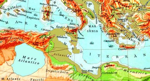
However, in November 2011, I came across an Italian website(b) that included two articles by Arecchi, which offer maps of two different locations for Atlantis. Nave di Atlantide? includes the North African site mentioned above. La Vera Atlantide incorrectly attributes Atlantis as a unified and much enlarged Balearic archipelago to Arecchi. I contacted Professor Arecchi, who confirmed that he is only advocating a site 100 miles SE of Malta (see map). The reference to Mallorca in the other article he attributes to a “free-interpretation” of his only thesis.
Arecchi claims that the people known as ‘Tjehenu’ or ‘Tenehu’ by the Egyptians were the Atlanteans of Plato’s narrative, an idea echoed by Ulrich Hoffman.
Arecchi’s book, referred to above, is now available as a free pdf file(c). Unfortunately, it is in Italian and pdf files are sometimes difficult to translate. Several papers relating to his architectural interests can be found on the academia.edu website. Two short reviews of Arecchi’s book by Flavio Barbiero and Emilio Spedicato are available online(j).
I believe this book to be an important contribution to the Atlantis debate so if I can find a suitable English translationt, I will post a link here. In the meantime, an abstract of his book, in English, is available online(d). A more extensive précis of his theories, in English and Italian, can be read in Archive 6912.
As a supporter of the idea of Atlantis in the Central Mediterranean, I find Arecchi’s concepts quite credible, although I would like to know more about the scientific evidence underlying them. An English translation of his book would help.
(a) https://www.liutprand.it/Atlantis.htm
(b) PETROGLIFI DI QUIACA (archive.org)
(d) https://www.liutprand.it/articoliMondo.asp?id=111
(e) https://www.liutprand.it/impero_atl.pdf (Ital) & https://atlantipedia.ie/samples/archive-2529/(Eng)
(g) NEWS: ATLANTIDE NEL CANALE DI SICILIA (archive.org)
(h) http://www.equinox-project.com/DRFEL.HTM
(i) The Arabian Horizon – The Cherokee Compass | MalagaBay (archive.org)