Latest News

Joining The Dots
I have now published my new book, Joining The Dots, which offers a fresh look at the Atlantis mystery. I have addressed the critical questions of when, where and who, using Plato’s own words, tempered with some critical thinking and a modicum of common sense.Read More »
Gibraltar Dam
Islam
Islam itself does not offer any evidence in support of Atlantis’ existence. However, the Qur’an was not intended as a history book(a). Nevertheless, several renowned medieval Arabic writers such as Al-Biruni, Al-Idrisi and Al-Mas’udi have been referred to as offering indirect but relevant evidence for the submergence of Atlantis in the Mediterranean following the breaching of a dam at Gibraltar. A more contemporary Iraqi scholar, Salah Salim Ali, in a twenty-page essay entitled Arabic References to Plato’s Lost Atlantis[077], discusses a possible link between Atlantis and “the City of Brass” referred to by medieval Arabic writers.
In 2014 an Indonesian website offered a more recent view of the Qur’an and Atlantis(b).
Adlantis was imagined by Ignatius Donnelly to be another form of Atlantis. He noted that the first inhabitants of Arabia were known as Adites. They were named after Ad who was fourth in line from Noah. Without any convincing reason, Donnelly states [0021.276] that “these Adites were probably the people of Atlantis or Adlantis.” The Qur’an (89:6-9) does refer to Ad(c) – Do you not see what your Lord did with ‘Ad-Iram of the Columns whose like was not created in any land? Iram has been identified as the city of Ubar discovered some decades ago(e), but, while Ad, Iram and Ubar may refer to the same place, there is no way that either can be linked to Plato’s Atlantis.
It is claimed that the Qur’an contains scientific knowledge that was not known fourteen hundred years ago(d).
(a) The Qur’an on the Lost City of Atlantis – Understanding Islam -under construction (archive.org)
(c) http://web.archive.org/web/20220701134018/https://atlantipedia.ie/samples/archive-3021/
Strait of Gibraltar
The Strait of Gibraltar according to Greek mythology was created by Herakles. Neville Chipulina explains that “it seems that the person responsible for the myths about Hercules was Peisander of Rhodes, a 7th century BC Greek epic poet who apparently got the story from an unknown Pisinus of Lindus who almost certainly plagiarised it from somebody else. In other words, it’s a pretty old story.”(c)
The Strait is very much a part of many current Atlantis theories. Primarily, it is contended that the region itself held the location of Atlantis. This is based on Plato’s statement that Eumelos, also known as Gadeirus, the twin brother of Atlas the first king of Atlantis gave his name to Gades, known today as Cadiz. Andalusia in Southern Spain has been the focus of attention for over a hundred years. In recent years Georgeos Diaz-Montexano and his rival Jacques Colina- Girard have been investigating the waters of the Strait itself while south of the Strait Jonas Bergman has advanced his theory that Atlantis was located just across the Strait in Morocco.
Although there is general acceptance that the Pillars of Heracles had their final resting place in the vicinity of the Strait of Gibraltar, it must be noted that there have been other candidates at different times with equally valid claims. The location of the ‘Pillars’ referred to by Plato at the time of Atlantis is the subject of continuing debate.
Archaeologist Josho Brouwers has noted that(g) “according to Strabo (3.5.5), Hercules raised the Pillars during one of his Twelve Labours to mark the western edge of the inhabited world. One pillar was identified as the Rock of Gibraltar (called Mount Calpe in ancient times), with the other was Ceuta (Mount Abile) on the African side of the narrow strait.
Diodorus Siculus mentions that Hercules put the Pillars in place as a monument to himself (4.18.4). He also adds that Hercules either narrowed the passage in order to prevent sea-monsters from the Atlantic to enter the Mediterranean, or to actually open the mountain so that the Atlantic could mingle with the Mediterranean. On this issue, as Diodorus puts it, “it will be possible for every man to think as he may please” (4.18.5).” For me it raises a warning flag regarding the hasty acceptance of ancient myths and traditions as having an historical basis.
Strato, the philosopher, quoted by Strabo, spoke of a dam separating the Atlantic and the Mediterranean being breached by a cataclysm. This idea was reinforced by comments of Seneca. Furthermore, a number of Arabic writers, including Al-Mas’udi, Al-Biruni and Al-Idrisi, have all concurred with this idea of a Gibraltar land bridge in late prehistory.
A more radical theory is that of Paulino Zamarro who contends that the Strait was in fact closed by a landbridge during the last Ice Age because of the lower sea levels together with silting. When the waters rose and breached the landbridge, he believes that the flood submerged Atlantis, which he situates in the Aegean. Others support Zamarro’s idea of a Gibraltar Dam amongst whom are Constantin Benetatos and Joseph S. Ellul.
Terry Westerman on his heavily illustrated website surveys impact craters globally. He suggests that “The Strait of Gibraltar was formed by two meteor impacts. The first blasted the round area in the western Mediterranean Sea to form a land bridge between Spain and Morocco.” He maintains that a second impact broke the landbridge around 5.33 million years ago, creating what is called the Zanclean Flood which refilled the then desiccated Mediterranean(d).
A German-language website(a) presented some of the following data+, apparently recording the dramatic widening of the Strait of Gibraltar between 400 BC and 400 AD. The same list was included in the ‘Strait of Gibraltar’ entry of the German Wikipedia(b) until a few years ago. It has since been removed.
Alexander Braghine offered [156.139] similar data*, which, unfortunately, is also unreferenced.
+Damastes of Sigeum, circa 400 BC. – about 1.3 km
+Pseudo-Skylax, probably fourth Century BC – about 1.3 km
*Turiano Greslio? 300BC – 8.0 km
*+Titus Livius (Livy) 59 BC- 17 AD – 10.5 km
+Strabo 63 BC- 24 AD – from 9.5 to 13.0 km
+Pomponius Mela , 50 AD – about the 15.0 km
+Pliny the Elder, 50 AD – about 15.0 km
*+Victor Vicensa (*Vitensa?), 400 AD – about 18 km
Procopius, 550 AD – about 15.0 km
The above figures suggest that in the latter half of the first millennium BC, the Strait of Gibraltar was gradually widened. However, the figures given suggest that between 400 and 550 AD the Straits narrowed again seems absurd. Nevertheless, until the methods used and all the data on offer have been verified, the idea must be treated with great caution.
My list had originally included Euctemon, the 5th century BC Athenian astronomer, however, Werner E. Friedrich notes that Euctemon was referring to the Sea of Marmara near the entrance to the Black Sea [0695.38].
However, more recently, John Jensen Jnr. has offered a comparable, if shorter, number of dates showing the reducing width of the strait the further back you go, from which he extrapolated that around 3450 YBP when he believes that a landbridge there was breached(e).
Jensen’s estimated widths for the strait are without references, but suggest a similar story of a gradually widening entrance to the Mediterranean.
1,100 BC 2 Miles (3.2 km}
480 BC 4 Miles (6.5 km
60 BC 7 Miles (11.2 km)
1200 AD 12 Miles (19.3 km)
Now 15 Miles (24 km)
Georgeos Diaz-Montexano has also referred to the descriptions by ancient writers of the Strait of Gibraltar indicating a width of around two kilometres. Unfortunately, he does not cite references(f). He is also sympathetic to the existence of an earlier landbridge at Gibraltar.
(a) https://de.academic.ru/dic.nsf/dewiki/1337738
(b) https://de.wikipedia.org/w/index.php?title=Stra%C3%9Fe_von_Gibraltar&oldid=60093153
(c) https://gibraltar-intro.blogspot.ie/2015/10/bc-pillars-of-hercules-if-ordinary.html
(d) The Formation of the Strait of Gibraltar (archive.org)
(e) https://www.migration-diffusion.info/article.php?id=514 and https://www.linkedin.com/pulse/earths-axis-tilt-john-jensen-jr-
(f) https://web.archive.org/web/20200630064033/http://freerepublic.com/focus/f-news/1011563/posts
(g) The Pillars of Hercules – Ancient World Magazine
Sarmast, (Robert) Behzad
(Robert) Behzad Sarmast is an Iranian-American and an architect by profession. He abandoned his career to pursue his lifelong passion for ancient history. He is the author of a book[535], in which he controversially placed Atlantis near Cyprus. His website(a) has an interesting collection of maps and diagrams. Coincidentally, the Urantia Book had previously identified a site in the Eastern Mediterranean as the location of Atlantis. Their description matches closely the underwater topography of Sarmast’s site and the Urantians have not been slow to exploit this coincidence(b) .
However, a 2016 sermon by Sarmast on the Urantia religion was published online
 Urantians have not been slow to exploit this coincidence(b). However, the link between Sarmast and the Urantians has not been actively admitted, although Sarmast’s publisher, Byron Belitsos, revealed that Urantian funding had been used to obtain the 3D computer modelling of the underwater topography of the seafloor off Cyprus, where Sarmast claims Atlantis was located. In October and November 2008, several blogs appeared under the name of Robert Sarmast(c). The content of these is religious in tone, although they make some references to Atlantis. However, a 2016 sermon by Sarmast on the Urantia religion was published online.
In 2003 Sarmast compiled a list of similarities between Plato’s description of Atlantis and the Urantia Book’s ‘Garden of Eden’(d) .
Sarmast organised an expedition in late 2004 that produced ‘evidence’ of manmade structures, including two ‘walls’ over 3 km long. The site is about seventy miles east of Cyprus towards Syria. At a press conference to announce his discoveries, Sarmast was challenged by Michel Morrisseau, a French geologist who lives on Cyprus, to prove that the Mediterranean had been inundated more recently than the conventionally accepted five million years. Sarmast had no convincing response. However, after that he attempted to bolster his views with the unsupported assertion that earliest geographers knew of the breaching of the Gibraltar Dam and that ancient traditions had it that Hercules used his giant mace to smash open the Dam and allow the Atlantic to flood the Mediterranean and so led to the association of Hercules with Gibraltar.
Much more work must be done before Sarmast can rightfully claim that he has discovered Atlantis. In the meanwhile, raise funds for the next expedition, his website sought to charge a monthly fee to provide interested ‘members’ with additional information on the preparations for the second expedition. This took place in 2006 with inconclusive results.
Sarmast returned to Cyprus in June 2011 to film a documentary in support of his theory. He had support from the Cyprus Tourism Organisation as well as the History Channel, together with some private investors. Filming took place during the Kataklysmos Festival, which interestingly celebrates the Deluge and/or Flood of Deucalion.
Since 2013, almost nothing further has been heard from Sarmast; his blogspot(c) is empty and there are no updates on the Discovery of Atlantis website(a)! It is informative to contrast today’s silence with the rhetoric of the initial 2003 press release(e).
However, in 2014, Sarmast had the more than dubious honour of being included in the online Encyclopedia of American Loons(h).
The Arysio dos Santos website offers a critical review of Sarmast’s book(g). Benny Peiser was even more disparaging, describing Sarmast’s claim as The Great Atlantis Hoax(i) on his CCNT network in 2004.
Although very little has been heard from Sarmast in recent years, two papers in 2014(k) and 2017(j) by Robert S. Bates attempted to breathe new life into Sarmast’s idea that the Mediterranean region around Cyprus had been home to both Atlantis and a/the Garden of Eden. Around the same time, Sarmast was given an entry in the Encyclopedia of American Loons(l).
Nevertheless, in 2025, Sarmast did return to Cyprus, but not in search of Atlantis. Instead, he wants to organise a new expedition to investigate what is known as the Latakia Ridge, which lies 20 miles off the coast of Syria and may have been connected to Cyprus in the distant past. Although emphasising that “we are not announcing the discovery of a lost city” his objective is to examine what he describes as a geometric anomaly on the Ridge. If he is not promoting a lost city, he had better explain the full title of his new book – The Sunken Peninsula: An Astonishing Underwater City at the Latakia Ridge [2122]. Another strange detail is that Amazon has the book listed with a suggested reading age of 10-18 years!!(m)
(a) See: https://web.archive.org/web/20180417053508/https://discoveryofatlantis.com/
(b) The theory of evolution What scientists believe it is and isn`t (archive.org)
(c)https://robertsarmast.blogspot.com/2008_10_01_archive.html
(d) https://web.archive.org/web/20180710105515/https://www.squarecircles.com/articles/atlantiseden.htm
(e) https://www.smh.com.au/articles/2003/09/30/1064819881656.html
(f) https://urantiareligion.com/transcript-for-urantia-religion-video/ {link broken May 2020}
(g) http://web.archive.org/web/20220629120224/https://atlantipedia.ie/samples/archive-3327/
(h) https://americanloons.blogspot.ie/2014/07/1109-robert-sarmast.html
(i) https://www.livescience.com/amp/91-claimed-discovery-atlantis-called-completely-bogus.html
(j) EAP-Essay-FINAL.pdf (evolving-souls.org)
(k) https://squarecircles.com/wp-content/uploads/2018/08/FirstEdenAnalysis.pdf
(l) Encyclopedia of American Loons: #1109: Robert Sarmast
Lampedusa
Lampedusa is the principal island of the Pelagian (Pelagie) archipelago off the coa st of Tunisia, between the African mainland and Malta, and is controlled by Italy.
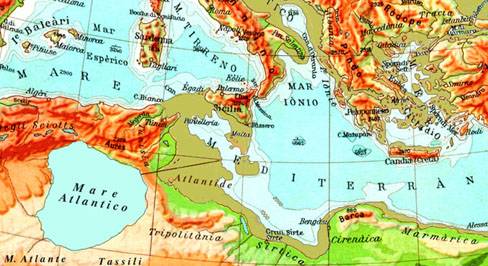
Anton Mifsud and his co-authors offer evidence[209] that Atlantis was actually a large island that joined Malta to Lampedusa and contend that the famous archaeological sites on Malta are just remnants of the Atlantean civilisation. However, as can be seen from bathymetric maps, if Malta were joined to Lampedusa, it might also have been connected with what is modern Tunisia, completing the Sicilian land bridge. This claim implies that if true , it is quite probable there was also a Gibraltar Dam and during the last Ice Age, the Mediterranean was reduced to a series of freshwater lakes.
A website(a) published by Diego Ratti has now highlighted that tiny Lampedusa has an interesting collection of megalithic remains, including a feature that has been  dubbed the ‘Lampedusa Stonehenge’.A 39-page booklet, by Ratti, which describes this feature in greater detail, can now be downloaded(b). Ratti is a financial consultant by profession and the author of two books, Wall Street Watchman and The Skywatching Trader. However, his love of astronomy, archaeology and Lampedusa came together in the development of his website.
In 2015, he published, in Italian, a book on the prehistory of Lampedusa, La preistoria di Lampedusa. In 2016, Ratti also discovered a “prehistoric underwater place of worship” off the eastern coast of the island(c), which he describes as a temple similar in layout to those found on Malta(d).
In the Introduction to a 2016 paper describing a prehistoric village on Lampedusa, he wrote “A prehistoric hut with Stentinello pottery found in Cala Pisana provided evidence for a late fifth millennium BC colonisation of Lampedusa island by people from Sicily, chronologically around the same time of the Malta early colonisation.”
In 2021, Ratti, controversially proposed in his new book Atletenu [1821], an Egyptian location for Atlantis, centred on the Hyksos capital, Avaris. Around the same time, he had some of his earlier postings removed from the internet!
(a) https://web.archive.org/web/20181128232114/https://www.megalithic-lampedusa.com/
(b) lampedusa-stonehenge (archive.org)
(e) About | Atletenu (archive.org)
(f) (99+) Lampedusa: prehistoric village of Tabaccara coast | Diego Ratti – Academia.edu (link broken) See: ARCHIVIO STORICO LAMPEDUSA: VILLAGGIO PREISTORICO DELLA TABACCARA *
Hausmann, Axel
Axel Hausmann (1939-2014) was a German physics professor at the Technical University of Aachen. He had  identified a circular underwater feature 20 miles due south of Syracuse in Sicily (36°45’N & 15°18’E) as the possible location of Plato’s city of Atlantis and south of that again existed the plain of Atlantis extending as far as Malta. He contended that Atlantis had an area of influence that stretched from Tunisia to Italy, including Malta and Sicily. He erroneously claimed in a paper presented to the 2005 Atlantis Conference [629.351] to be the first to suggest the Central Mediterranean region as a runner in the Atlantis Stakes(c). However, he does appear to be the first scientist to promote the idea of a late breaching of a Gibraltar Dam leading to the inundation of Atlantis.
Hausmann placed the Pillars of Heracles at what was formerly a narrow strait between northeast Tunisia near what is now Cape Bon and an enlarged Sicilian landmass, which incorporated Malta.
He dated the submergence of Atlantis to around 3500 BC, based on the assumption that Plato’s ‘years’ were Egyptian seasons (three per solar year). He perceived the remarkable megalithic temples on Malta & Gozo as the remnants of Atlantis and anticipated similar discoveries on Sicily. Hausmann’s dating of Atlantis is the only major detail in his theory with which I disagree.
In a paper delivered to the 2005 Atlantis Conference on Milos, Hausmann speculated that the famous cart-ruts of Malta were irrigation channels[629.356], ignoring the fact that they follow the natural undulations of the landscape, unless he thought that these Maltese Atlanteans found a way to make water flow uphill.
Hausmann has also followed the suggestion of the late Ulf Richter who argued that the linear measurements of Atlantis used the Egyptian khet (52m)as the unit of measurement rather than the Greek stade (175m).
Hausmann proposed that the survivors of the catastrophe migrated to Crete, Egypt and Syria, where they provided the stimulus for the subsequent civilisations of Egypt, Minoan Crete and Sumer. He specifically identified the Phaistos Disk[372] as possibly having been brought to Crete by Atlantean refugees and also presented a paper on this idea to the 2005 Atlantis Conference(c). He has written a number of books, including a second volume more directly related to Atlantis, Atlantis – Die Versunkene Wiege der Kulturen (Atlantis-The Sunken Cradle of Culture)[371].
Hausmann has written a two-part paper entitled Atlantis war Sizilien (Atlantis is Sicily) available on the Atlantisforschung.de website(a)(b). In it, he echoes my own view that it seems incredible that commentators place Atlantis in locations on every continent and ignore the only region that Plato unambiguously identified as Atlantean territory, namely the Central Mediterranean, from Southern Italy to North Africa (Crit. 114c & Tim. 25a/b).
Hardy, C. C. M
C. C. M Hardy was a contributor to Egerton Sykes’ Atlantis magazine from its year of inception.
Hardy subscribed to the view that there had been a dam at Gibraltar that was breached around 4500 BC with such a force that it also led to the destruction of a landbridge between Tunisia and Italy.
In issue 2 of Egerton Sykes’ (Atlantean) Research (July/August 1948) he argued strongly against Ignatius Donnelly’s chosen Atlantis location of Azores. In sharp contrast, he believed that remnants of Atlantis will be found in the seas around Greece.
In 1966, he investigated the possibility of setting up a University Chair of Atlantean Studies either in the USA or Europe(a). Unfortunately, the idea did not appeal to conservative academia and was consequently shelved. I think that there is even more validity in the idea today.
It is remarkable, therefore, that commencing January 2017, the University of Oxford offered a short course on Plato’s Atlantis. The lecturer is Stephen P. Kershaw, a specialist in Greek mythology(b), which suggests that the lectures may only be concerned with the mythological content of the Atlantis narrative without due regard for any possible historical underpinnings. Kershaw had A Brief History of Atlantis published as a Kindle book in September 2017.
(a) https://web.archive.org/web/20250125133758/http://www.seachild.net/atlantology/
(b) https://web.archive.org/web/20180315161815/https://www.conted.ox.ac.uk/courses/platos-atlantis
Discovery of Atlantis
Discovery of Atlantis [535] by Robert Sarmast presents a determined argument for locating Atlantis close to the island of Cyprus in the eastern Mediterranean. The author claims to have used nearly fifty clues from the works of Plato to pinpoint an area south of Cyprus in waters a mile deep.
However, there is one fundamental weakness with his theory, namely, that the depth at which his proposed site is located (1,650 metres) would have required a Gibraltar Dam and desiccation of the Mediterranean within human memory, which is more recent than conventional wisdom currently allows. It would seem more cost-effective to invest in an in-depth review of the evidence for an inundation of the Mediterranean within historical times before engaging in an expensive underwater expedition.
Using new scientific data, Sarmast has offered a number of 3-D bathymetric maps of this underwater site that can be matched to the topographical descriptions offered by Plato. The author presents his hypothesis as superior to any previously proposed location.
Sarmast is convinced that a fully equipped diving expedition will confirm his belief with clear images of buildings and artefacts. An expedition in late 2004 produced further images that Sarmast claims to indicate structures matching Plato’s description. There was an immediate claim by a German physicist, Christian Huebscher that the features in question were underwater volcanoes that he had previously surveyed [the text should have read as ‘mud volcanoes’ rather than ‘underwater volcanoes’]. Sarmast responded with a demand that Huebscher proves that the particular mound that he identified as the acropolis of Atlantis was a mud volcano.
The book and the associated website(a) are well illustrated and a new theory for students of the Atlantis mystery to consider. Recently, Sarmast has received support from Colin Wilson who previously supported an Antarctic location for Atlantis.
The believers in the Urantia Book have received unexpected support from Sarmast’s claims as their ‘holy book’ had identified Cyprus as the location of one of its two ‘Gardens of Eden’ in the eastern Mediterranean.
(a) https://web.archive.org/web/20190511040418/http:/www.discoveryofatlantis.com:80/
Arecchi, Alberto
 Alberto Arecchi, born in 1947, is an architect and professor of Design and history of Art in Pavia in Italy, where he lives. He is the president of the Cultural Association Liutprand. He has spent fifteen years in Africa working on international development projects. He is the author of many books relating to European History.
Arecchi has also written about Atlantis in Atlantide, Un mondo scomparso and Alla scoperta di Atlantide, in which he builds on investigations originally begun in the 1920s by F. Butavand and Jean Gattefosse. Arecchi’s book [079] contains some radical ideas:
(i) it supports the theory of an extensive Sicilian land bridge between Europe with Africa,
(ii) it locates Atlantis off the coast of modern Tunisia and
(iii) it posits the existence of a large inland sea, the original Atlantic ‘Sea’, in part of what is now the northern Sahara, where the chotts of Algeria and Tunisia now are.(k)
He claims that all this ended around 1225 BC when seismic activity in the region caused the land bridge to disappear and the dam that contained the inland sea to rupture and Atlantis to vanish. His date is based on the interpretation of Plato’s 9,000 ‘years’ as 9,000 lunar cycles. Arecchi further claims that the Gibraltar Dam was breached around 2500 BC. He also envisages the Maltese Islands connected to both Sicily and Tunisia before this breach.
An outline of his understanding of the Atlantis story, in Italian and English, can be found on the Internet(e) in a 2004 paper entitled Empire of Atlantis: From the Mediterranean to the New World, in which he reviews the evidence for early Mediterranean influences in the Americas and particularly the work of the controversial Barry Fell, who identified North African scripts on markers at a number of locations in North America. Arecchi sees this as support for his Atlantis location off the coast of today’s Tunisia and that there was trans-Atlantic Atlantean influence!
In fairness, I think that the contentious opinions of Fell deserve a look, along with a vindication of his epigraphic work(h) as well as further corroboration by more recent DNA studies(i).
Part of Arecchi’s theory includes a landbridge between Italy and North Africa, in his own words – “At that time, the sea today known as the Mediterranean Sea had to be divided into two parts, placed at different levels and deprived of mutual communications. The western Mediterranean and the Tyrrhenian were – as they are today – in communication with the Ocean, through Gibraltar, opened more than a thousand years before. The eastern part – i.e. the Greeks’ Mediterranean – was properly an “interior sea”, like a lake, from the Small Syrte to the Syro-Palestinian coasts, including lower Adriatic and Candia Sea (while the Aegean territory, all emerging, was a plain, crowned by volcanic mountains). Its waters would be approximately 300 m under the level of today. We will note this level as “level zero”, in order to measure the relative altitudes.” (see map)
The suggested Sicilian land bridge was more than a possibility if the Gibraltar Dam had been a fact. By cutting off the waters of the Atlantic, desiccation in the Mediterranean would have brought the level of its water below that of the Atlantic, creating at least two very large inland lakes and exposing the Sicilian land bridge. Diaz-Montexano supports the idea of this isthmus or land bridge, an idea reinforced by the comments of both Strato and Seneca.
However, in November 2011, I came across an Italian website(b) that included two articles by Arecchi, which offer maps of two different locations for Atlantis. Nave di Atlantide? includes the North African site mentioned above. La Vera Atlantide incorrectly attributes Atlantis as a unified and much enlarged Balearic archipelago to Arecchi. I contacted Professor Arecchi, who confirmed that he is only advocating a site 100 miles SE of Malta (see map). The reference to Mallorca in the other article he attributes to a “free-interpretation” of his only thesis.
Arecchi claims that the people known as ‘Tjehenu’ or ‘Tenehu’ by the Egyptians were the Atlanteans of Plato’s narrative, an idea echoed by Ulrich Hoffman.
Arecchi’s book, referred to above, is now available as a free pdf file(c). Unfortunately, it is in Italian and pdf files are sometimes difficult to translate. Several papers relating to his architectural interests can be found on the academia.edu website. Two short reviews of Arecchi’s book by Flavio Barbiero and Emilio Spedicato are available online(j).
I believe this book to be an important contribution to the Atlantis debate so if I can find a suitable English translationt, I will post a link here. In the meantime, an abstract of his book, in English, is available online(d). A more extensive précis of his theories, in English and Italian, can be read in Archive 6912.
As a supporter of the idea of Atlantis in the Central Mediterranean, I find Arecchi’s concepts quite credible, although I would like to know more about the scientific evidence underlying them. An English translation of his book would help.
(a) https://www.liutprand.it/Atlantis.htm
(b) PETROGLIFI DI QUIACA (archive.org)
(d) https://www.liutprand.it/articoliMondo.asp?id=111
(e) https://www.liutprand.it/impero_atl.pdf (Ital) & https://atlantipedia.ie/samples/archive-2529/(Eng)
(g) NEWS: ATLANTIDE NEL CANALE DI SICILIA (archive.org)
(h) http://www.equinox-project.com/DRFEL.HTM
(i) The Arabian Horizon – The Cherokee Compass | MalagaBay (archive.org)
Cyprus
Cyprus has now been shown to have had an agricultural settlement as early as 9000 BC(c). In 2005, it was claimed that flints were found on Cyprus and dated to a possible 10,000 BC, offered evidence of the earliest long-distance sea travel in contrast to earlier shore-hugging(g). I would question this, since twelve thousand years ago sea levels were much lower and landmasses in the eastern Mediterranean were more extensive, removing the need for lengthy sea travel. Cyprus would have been much more easily accessible and what is now the Aegean consisted of more land than water.
Cyprus was also added to the list of possible Atlantis sites with the publication of Discovery of Atlantis[535] in 2003, which offered a radical new theory by Robert Sarmast. Excerpts from the book were selected by Sarmast and published in Atlantis Rising magazine(No.43)(o). This theory is based principally on 3-D images of a section of the present seafloor near Cyprus. Sarmast has compiled an impressive list of similarities between Plato’s description of Atlantis and the underwater topography. He also claims to have identified a wall 3km long wall that intersects with another. A YouTube clip centred on Sarmast’s 2004 expedition is available online(i).
Although it is true to say that this is a radical theory, it is not a completely new idea as the Urantia Book(a) had already suggested an Atlantis/ Eden off the coast of Cyprus. The Urantia Book specifically claims that this Eden was a long narrow peninsula, almost an island projecting westward from the eastern shores of the Mediterranean Sea (Paper 73). This detail coincides remarkably with Sarmast’s claim.
 I must point out, that in order to uncover this putative site, the sea level would have to be dropped 5,250 feet. Now, the only explanation for this would be the existence of at least one archaeoastronomer in the Mediterranean, probably at Gibraltar within the memory of man, a suggestion advocated by Sarmast but, crucially, without any supporting evidence. This is quite feasible, as it has been shown that the Mediterranean has dried out on a number of occasions in the past. Current orthodoxy places the last inundation of the Mediterranean by the Atlantic around five million years ago. However, Paulino Zamarro, among others, has postulated the existence of the Gibraltar Dam within human prehistory, which, if true, would add to the credibility of Sarmast’s theory. However, if the Mediterranean had dried out, the result would have left Sarmast’s location with a thick salty deposit, a far cry from the fertile land described by Plato.
Supporters of Sarmast’s theory have drawn attention to the annual Festival of the Flood, an event unique to Cyprus when people in coastal towns sprinkle each other with water to commemorate the salvation of Noah.
In 2005, Philip Coppens published a review of Sarmast’s theory commenting, “And some of the maps he and his team of researchers have been able to get from the area in question do seem to indicate that Atlantis may indeed be located there. Though much more work is required, at least, this possibility is more hopeful than so many of the alternatives…”(h)
Nevertheless, Sarmast’s mile-deep location contradicts Plato’s description of the sunken capital of Atlantis, that even in Solon’s or Plato’s time, was described as existing in unnavigable shallows.
Since Plato, sea levels have only risen a few feet, not by a mile. Sarmast should have focused on demonstrating the existence of a landbridge or dam at Gibraltar or Sicily and witnessed by man. No landbridge – No Atlantis at Cyprus!
Professor Arysio dos Santos, who wrote, Atlantis: The Lost Continent Finally Found[320] in which he proclaimed his idea that Atlantis was located on the huge swathes of territory around Indonesia, which were inundated at the end of the last Ice Age, has also written(b) a paper denouncing the claims of Robert Sarmast as “an obvious hoax and a possible scam”[0320.189]
However, Colin Wilson, who previously supported the idea of Atlantis in Antarctica[063] switched his support to the Cyprus location, which led to him writing the foreword to the 2006 expanded edition of Sarmast’s book. In 2009, Robert L. Gielow, a fundamentalist creationist, also added his endorsement to Sarmast’s theory in another book[808]. In two papers, in 2014(k) & 2017(l), Robert S. Bates offered further support to Sarmast’s location theories.
A further claim placing Atlantis south of Cyprus on a scarab-shaped underwater feature (33°N-33°E), has been made by blogger, Nicolas Fenning. He has also suggested that Freemasonry, Macedonia and the Pharos Lighthouse, all have links with Atlantis. He also maintains that clues to its location were contained in DaVinci’s Last Supper(d)!
Although little has been heard from Sarmast in recent years, the idea of Atlantis near Cyprus was apparently given a boost in early 2018, when it was reported that Atlantis had been discovered off Paphos. However, any euphoria was quickly dissipated when the last lines of the report(j) were reached. “This news article was compiled from a press release issued by the CTO on April 1, which celebrates April Fool’s Day – a day where practical jokes and hoaxes are spread.”
In April 2022 it appeared that Sarmast is once again trying to resurrect interest in his Cypriot Atlantis location(m). I have not had this report confirmed. However, I now see that Robert S. Bates, mentioned above, is due to have a short book [1961] published in February 2023, entitled The Eden-Atlantis Project, which puts forward the case for a third expedition to find Eden/Atlantis near Cyprus. This proposed expedition seems to be led by Bates, now promoted to commodore, with minimal reference to Sarmast(n).
In 2024, Jordi Guri Harth published Atlantis-The Cypriot Empire [2092] in an effort to regenerate support for the idea of Atlantis in Cyprus.
(b) Statement on the Alleged Discovery of Atlantis Off Cyprus | Atlantis (archive.org)
(d) https://atlantisrediscovered.weebly.com/atlantis-re-discovered.html
(e) https://atlantisrediscovered.weebly.com/atlantis-re-discovered-part-ii.html
(f) Archive 2775 | (atlantipedia.ie)
(h) http://web.archive.org/web/20200930201445/http://atlantipedia.ie/samples/archive-2934/
(i) https://www.youtube.com/watch?v=RcI7Zg0lxzA
(j) https://cyprustraveller.com/atlantis-paphos-6828-2/ (link broken)
(k) https://squarecircles.com/wp-content/uploads/2018/08/FirstEdenAnalysis.pdf
(l) EAP-Essay-FINAL.pdf (evolving-souls.org)
(m) https://www.travelmole.com/news/atlantis-discovered-near-cyprus/
(n) http://edenatlantisproject.org/
(o) Atlantis Rising (No.43)
Cyclades
The Cyclades are a group of twenty-four islands, which encircle the sacred isle of Delos, in the Greek Aegean Sea. Vasilios Kapsimalis from the Hellenic Centre for Marine Research related to the 2005 Atlantis conference how the Cyclades, which originally had a land surface of around 7000 sq kilometres, lost 75% of their area following the raising of sea levels after the last Ice Age. A pre-Greek civilisation flourished there,  which had no written language, but is probably best known today for its distinctive marble figurines. The origin of the Cycladic culture is hotly debated with Egyptian and/or Phoenician connections as the leading contenders.
Kurt L. Lambeck, a Professor of Geophysics at The Australian National University in Canberra, charted the reduction of the Cyclades from a landmass of approximately 160 x 85 km (13,600 km2) to the archipelago we know today as having an area of 2,572 km2. He suggests that a memory of the break-up of this large landmass may have been the source of Plato’s Atlantis. His findings in the Aegean have been published in Antiquity[0430] and maps of sea level changes based on his investigations are also available on the internet.
Lambeck’s sea level data has been harshly criticised by Izabol Apulia(c), who has developed a large series of maps showing the ancient coastlines of most Mediterranean islands at various stages since the Last Glacial Maximum.
Paulino Zamarro in his book[024] locates Atlantis in the Cyclades, with its capital on Melos. He contends that around 5500 BC, following the breaching of the Gibraltar Dam, the Cyclades were inundated and as the waters of the Mediterranean rose, the plug in the Bosporus broke, enlarging dramatically what was then a much smaller freshwater, Black Sea.
In connection with Zamarro’s theories, it is worth noting that it is conventionally accepted that the Cyclades were first inhabited around 5000 BC. If Zamarro is correct, an earlier occupation date is possible, but the rising waters of the Mediterranean would possibly have submerged much of the evidence for it. Consequently, any reconstruction following the inundation would be inland from the original coastline and would only show an approximate date of no earlier than 5000 BC.
Diamantis Pastras seems to have been the first to suggest a Cycladic location for Atlantis in a paper sent to the Greek Ministry of Culture in 1989. In it, he claimed that 3,500 years ago, the Cyclades, together with the island of Astipalea, had formed a single landmass and was the location of Atlantis. He bases his theory on an interpretation of a map in the Egyptian Book of the Dead.
At the 2005 Atlantis Conference held on the Cycladic island of Melos a paper was presented [629.227] by four members of the Hellenic Centre for Marine Research, which outlines the hydrographic history of the islands that saw the gradual reduction of the much larger landmasses that existed at the time of the Last Glacial Maximum, to the much smaller islands that we have today. The authors suggest the possibility that the story of this continuous flooding may have been ’embellished’ by Plato and incorporated into the Atlantis narrative! I doubt it.
In 2014, Christos A. Djonis published Uchronia – Atlantis Revealed [935], in which he claims that Atlantis lay in the Aegean Sea, to the north of Thera, which itself contained the capital city of the Atlantean confederation. However, he gives no credit to Paulino Zamarro, who proposed a similar location fifteen years ago.
Jason Colavito had an interesting piece(a) on a geologist’s view when he wrote that “In 2010, geologist Kalliopi Gaki-Papanastassiou (b) and several colleagues proposed a similar theory identifying the Cycladic

Kalliopi Gaki-Papanastassiou
island with Atlantis in a chapter of the edited volume Coastal and Marine Geospacial Technology, though they admitted it was speculation based on the unproven assumption of the existence of a city-state and based on throwing out details from Plato that didn’t match. However, they felt confident that the existence of Neolithic cultures in the surrounding area proved that an advanced culture existed between them. They did not propose a method whereby knowledge of this city-state—but no other aspect of Neolithic culture—transmitted from the Cyclades to Egypt to Plato. Gaki-Papanastassiou also claims to have found Homeric Ithaca by studying prehistoric coastlines.” They suggested a location for Atlantis amid the adjacent Cycladic islands of Naxos, Paros and Antiparos.
(b) Gaki Kalliopi (archive.org)
(c) http://web.archive.org/web/20191018214327/https://atlantipedia.ie/samples/archive-2566/
(d) http://milos.conferences.gr/index.php?id=2856 (link broken)