Latest News

Joining The Dots
I have now published my new book, Joining The Dots, which offers a fresh look at the Atlantis mystery. I have addressed the critical questions of when, where and who, using Plato’s own words, tempered with some critical thinking and a modicum of common sense.Read More »
Dave Truman
Geodesy
Geodesy is usually defined as the measurement and mapping of the Earth. James R. Smith, the author of Introduction to Geodesy [1947] has conflated several definitions to produce “Geodesy, from the Greek, literally means dividing the earth, and as a first objective, the practice of geodesy should provide an accurate framework for the control of national topographical surveys. Thus, geodesy is the science that determines the figure of the Earth and the interrelation of selected points on its surface by either direct or indirect techniques. These characteristics further make it a branch of applied mathematics, one that must include observations that can be used to determine the size and shape of the earth and the definition of coordinate systems for three dimensional positioning; the variation of phenomena near to, or on the surface, such as gravity, tides, earth rotation, crustal movement, and deflection of the plumb line; together with units of measurement and methods of representing the curved earth surface on a flat sheet of paper.”
Geodesy as a science can be traced back to Pythagoras (6th cent. BC), who was thought to be the first to propose the sphericity of the Earth. Aristotle & Archimedes were apparently the first to offer a figure for the diameter of the Earth, suggesting 400,000 and 300,000 stades, respectively. The difference might be partly explained by the use of a different length of stade.
Later, Eratosthenes (276 BC– 195 BC) offered another early attempt to determine the dimensions of our Earth and succeeded with remarkable accuracy.
A controversial aspect of modern geodesy is the claim that many ancient sites were deliberately established at locations that had a specific geodetic relationship to each other and/or the dimensions of the Earth. For example(a) in ancient Egypt, the distance from Giza to the Equator was calculated to be 1/12th the circumference of the Earth, Amarna to the Equator is 1/13th, Luxor 1/14th and Philae 1/15th!
Graham Hancock in his Heaven’s Mirror[855] pointed to similar relationships around the globe, suggesting a possible world grid. This idea of a world grid has a number of supporters, but is often classified as a ‘fringe’ interest, due to the attempt by some to link gridlines with UFOs and their use of the grid as a power source(w). Hancock’s various claims regarding the dimensions of the pyramids and their association with a suggested world grid has been challenged in great detail by a Hall of Maat article by Thomas W. Schroeder(ah). He concluded that “Graham Hancock’s assertion that the Great Pyramid’s dimensions reveal knowledge of earth’s dimensions certainly lacks proof but also fails to hold up to any scrutiny as a viable theory. Each step argued by Hancock; that the Great Pyramid was built to a specific scalar, that the value of the scalar can be definitively demonstrated, that the scalar indicates precession, that the only way ancient Egyptians could estimate precession is to leverage or borrow knowledge from earlier advanced and unrecognized civilizations, are each filled with flaws when taken individually, let alone when strung together to complete his narrative.”
The idea of a global grid has been pursued by a number of investigators, often with conflicting results. In the 1980s, William Becker and Bethe Hagens, published their widely referenced Planetary Earth Grid(aj). They “discussed the code of the Platonic Solids’ positions on Earth, ascribing this discovery to the work of Ivan P. Sanderson, who was the first to make a case for the structure of the icosahedron at work in the Earth. He did this by locating what he referred to as Vile Vortices refer to a claim that there are twelve geometrically distributed geographic areas that are alleged to have the same mysterious qualities popularly associated with the Bermuda Triangle, the Devil’s Sea near Japan, and the South Atlantic Anomaly.”(ak)
Possible related features may be the ley lines identified by Alfred Watkins in Britain(c)(g), the Alesia alignments in France discovered by Xavier Guichard(b) and/or the Heilige Linien of Germany, claimed by Wilhelm Teudt(aa) and supported by Henrich Himmler.
Xavier Guichard (1870-1947) is described as a Paris police chief and philologist. Between 1911 and 1936, he carried out an extensive study of French place-names and found that there were at least 400 sites with names derived from Alesia. When mapped, these hundreds of sites all lay on lines radiating from today’s town of Alaise, reminiscent of Alfred Watkins leylines! Francis Hitching, in The World Atlas of Mysteries [307.78] tells of how Guichard self-published his book, only to have his home bombed during the war in 1945, killing him and destroying most copies of his book. Elsewhere(b) the year of his death is given as 1947! Hitching included two maps reconstructing Guichard’s work.
Ashley Cowie has published a paper(ac) related to Alesia and the work of Guichard and others, as well as his own investigations.
Heinz Kaminski claimed to have discovered a megalithic grid system that stretched from Stonehenge across Europe with an east-west and north-south orientation and referred to as the Stonehenge/Wormbach System(h).
Even more exotic is the ancient Raetiastone navigation system rediscovered by Gerhard Pirchl (1942-2013) and outlined in a book by [1831] Thomas Walli(ae).
I should point out that Marcel Mestdagh also identified a form of a road system, laid out in giant ovals with radials in France. At the centre of these ovals was the ancient city of Sens. Philip Coppens informs us [1275.184] that a further strange discovery by Mestdagh, was that this ancient road network, centred on Sens, was mirrored by a similar network of roads in England, centred on Nottingham!
‘The Way of Virachoca’ in the Andes, which runs through Tiwanaku and is oriented exactly 45° west of true north and runs for over 1000 miles, it has been studied by Maria Scholten d’Ebneth [1236] in the 1970s and expanded on by a number of Spanish speaking commentators and is now the subject of an article by Dave Truman(x).
In 1973, three Russians, engineers Valery Makarov and Vyacheslav Morozov, along with Nikolay Goncharov, an artist, published an article in Russian with the eye-catching title of, Is the Earth a Giant Crystal? (y) This was probably the earliest presentation of an earth grid based on ancient historical sites. A brief history of the Earth grid theories that emerged around this time is available online(z). There is now a Russian geodesy website with an English translation(ab).
David Hatcher Childress published his Anti-Gravity and the World Grid [1303] in 1993, with the modest claim that he “proves that the earth is surrounded by an intricate electronic grid network offering free energy.” Obviously, Childress’ understanding of ‘proof’ is different to mine, as the only proof required is the production of some of this free energy, which he has not done.
Tom Brooks(ai) entered the fray with a study of 1500 prehistoric sites and his conclusion that the inhabitants of ancient Britain had designed a navigation system based on a grid of isosceles triangles(i). Brooks has gone a step further and speculatively claimed that the accuracy of this geometry-based system could only have been designed through “extraterrestrial intervention”(r). This concept is explored more fully in his latest book, Seeing Around Corners: Geometry in Stone Age Britain [863] and in a series of video clips(s). A more critical view of Brooks’ ideas is also available on the Internet(j).
Some years ago, a former employee of a NASA sub-contractor, Maurice Chatelain, claimed that within a 450-mile radius of the Aegean island of Delos, 13 mystical sites, when connected by straight lines formed a perfect Maltese Cross(u)!
Others such as Livio Stecchini(d) and Jim Alison(e) using geodetic calculations, have identified São Tomé and Cape Verde, respectively as the location of Atlantis. I must also include Hugo Kennes, a Belgian researcher with a passionate interest in global grids and sacred geometry(l). Kennes has also informed me of a new Facebook group(q) which deals with all aspects of the subject, as well as another(v) that includes submerged cities and other features.
Anyone interested in pursuing a study of this subject might like to look over James Q. Jacobs’ archaeogeodesy website(f) as well as the BioGeometry website (m).
If you have pursued all the links so far, you can pamper yourself further with a paper(k) by William Becker and Beth Hagens(n). Another researcher in this field is Dan Shaw, whose website(o) gives a good overview of the subject.
Jean-Pierre Lacroix added his weight to the debate with his 1998 paper entitled, The Mapmakers from the Ice Age(t).
A global network of sacred sites was also put forward by Rand Flem-Ath & Colin Wilson in, The Atlantis Blueprint [063]. This book was intended as a sequel to, When the Sky Fell [062], but it generally wandered off into other areas after the first couple of chapters.
I am somewhat sceptical about certain aspects of geodesy, particularly some of the claims of a world grid. However, it does raise many questions that require further study and explanation. In this connection, I would recommend John Sase’s, Curious Alignments [1589] as a good starting point. He confirms the work of Guichard and also offers a range of his own discoveries in the Great Lakes region.
In February 2020, Frank Maglione Nicholson, Ken Phungrasamee & David Grimason, collectively known as The Nazca Group(ad), published, The Nazca Great Circle Map Hypothesis. Their claim is that “The lines and geoglyphs carved into the Nazca plateau represent a map of the Earth. The map is a Great Circle Map: a gnomonic projection, with the center of the Earth as its cartographic viewpoint. Each line on the Nazca Plateau represents a great circle of navigation centred at the centre of the Earth and encircling the entire planet. The majority of the lines on the Nazca Plateau radiate from five loci of origin called radial centres.” I found this rather esoteric proposition difficult to absorb.
Arturo Villamarin has published many books [1864] and papers(af)(ag) in which the geometry and astronomy of archaeological monuments; Göbekli Tepe, Stonehenge, Teotihuacán and Mohenjo Daro, among others, are discussed.
(a) http://www.ancient-wisdom.com/geodesy.htm
(b) http://www.ancient-wisdom.com/xavierguichard.htm
(c) http://www.ancient-wisdom.com/leylines.htm
(d) http://www.metrum.org/mapping/atlantis.htm (link broken Dec. 2020)
(e) http://home.hiwaay.net/~jalison/concl.html
(f) https://web.archive.org/web/20200917015056/http://www.jqjacobs.net/index.html
(g) https://liminalthresholds.blogspot.ie/2008/04/earth-energy-ley-lines.html
(i) See: https://web.archive.org/web/20160628154229/https://www.prehistoric-geometry.co.uk/
(j) https://www.badscience.net/2010/01/voices-of-the-ancients/
(k) https://www.bibliotecapleyades.net/ciencia/antigravityworldgrid/ciencia_antigravityworldgrid02.htm
(m) https://web.archive.org/web/20170328094319/https://www.biogeometry.org/page34.html
(n) Bethe Hagens – Geometry, Anthropology anf the Arts of Consciousness (archive.org)
(o) https://www.vortexmaps.com/grid-history.php
(q) https://www.facebook.com/groups/175027289350368/
(r) https://www.prehistoric-geometry.co.uk/ [See (i)]
(s) https://www.youtube.com/watch?v=R35A80kV0AU&feature=relmfu
(t) https://ancientcartography.net/geoAN.html
(u) https://www.mail-archive.com/ctrl@listserv.aol.com/msg28306.html
(v) https://www.facebook.com/groups/493298404177687/
(x) https://grahamhancock.com/trumand1/
(y) http://web.archive.org/web/20220819135530/https://atlantipedia.ie/samples/archive-3193/
(z) https://www.vortexmaps.com/grid-history.php
(aa) https://www.cantab.net/users/michael.behrend/repubs/teudt_hl/pages/index.html
(ac) Solstice Axis Of The Ancient Gauls — ASHLEY COWIE (archive.org)
(ad) The Nazca Solution – The final solution to what the Nazca Lines represent (archive.org)
(ae) https://www.megalithic.co.uk/article.php?sid=2146413597
(ag) (99+) (PDF) THE GEOMETRY AND ASTRONOMY OF GOBEKLI TEPE | Arturo Villamarin – Academia.edu
(ai) https://www.megalithic.co.uk/article.php?sid=2146413745
(aj) Microsoft Word – antigravity.doc (montalk.net)
(ak) https://www.crystalinks.com/grids.html
Tiwanaku (Tiahuanaco)
Tiwanaku (Tiahuanaco) is an ancient city whose remains are located over two miles above sea level near the southern end of Lake Titicaca on the Altiplano of Bolivia. It was first encountered by Spanish conquistadors in 1549. Tiwanaku has all the features of a harbour, which has led some to describe it as the seaport of nearby Puma Punku another remarkable ancient site(o).
 The ruins are scattered over a number of square miles through which the Guayqui-La Paz railway was constructed, which was responsible for the breaking up of many monuments to provide ballast. Before that, stone from the site was used in the construction of nearby homes and a church.
Belisario Díaz Romero believed that Tiwanaku had been built by a race of people he calls Homo atlanticus, who had come to America from Atlantis over a landbridge from the east, outlined in his 1906 book Tiahuanacu[1235]. Heather Pringle notes(t) that before Romero, “Francis de Castelnau (1810-1880), for example, proposed in the mid-19th century that Tiwanaku was the work of wandering Egyptian pharaohs, as opposed to the ‘imbecilic race that inhabits the country today’.”
The controversial Arthur Posnansky, who linked Tiahuanaco with Aztlan, the mythical “white” island homeland of the Aztecs investigated them in the early 20th century. The similarity of Aztlan with the name of Plato’s city has excited some straw-clutching Atlantis seekers into claiming a definite connection between the two.
Posnansky also noted that the expected alignments of structures at Tiwanaku were offset by an amount that suggested their construction at a time when they would have been correctly aligned to the cardinal points. He, after many years of study, was convinced that Tiahuanaco was the oldest civilisation on Earth [516] dating it to around 15,000 BC, which he later reduced to 10,000 BC.
In the 1920s, Edmund Kiss studied the ruins of Tiwanaku and concluded that it had been constructed by Nordic refugees from Atlantis which had been destroyed by a falling moon! His ideas were enthusiastically received back in Nazi Germany. A further expedition was planned but never materialised because of the start of World War II.(u)
Dr Graham Holton, an Australian commentator has written about the pseudo-science practised in the early 20th century at Tiwanaku by the likes of Posnansky and Kiss and endorsed by Hörbiger and Hans Bellamy(al)(am).
Although, as you can see below, Posnansky’s work and particularly his dating of Tiwanaku has been rejected by many, he still has supporters. In Graham Hancock‘s 1995 book Fingerprints of the Gods [275], he supported Posnansky’s date, referring to his work throughout the book. Ian Alex Blease, a devout sceptic took issue with this endorsement (aa). For my part, I note that Hancock was happy to support Posnansky in ‘Fingerprints’, but in America Before [1680], despite its title, he gives Posnansky’s date no mention, perhaps because it clashed with his new date for the destruction of his ‘Lost Civilisation’!
Hancock has been highly critical of Carbon-14 as a dating method, particularly for megalithic sites and specifically Tiwanaku. The late Garrett Fagan took issue with Hancock regarding the dating of Tiwanaku in a 2000 post on Hancock’s site(ar). Hancock responded with a challenge to Fagan that led to a further article from him(aq). The temperature rose with a further article from Hancock(as).
Charles Orser Jnr. debunked Posnansky’s dating in a 2001 article(k) as did Paul Heinrich(n).
Marin, Minella & Schievenin [972.97] “Between 1927 and 1930 several scientists, including Hans Ludendorf, at the time director of the Astronomical Observatory of Potsdam; astronomer Arnold Kohlshutter, University of Bonn; Dr Rolf Muller, University of Potsdam and Dr Friedrich Becker, Specula Vatican, meticulously checked the archaeological-astronomical research of Posnansky for accuracy. After three years of work these scientists corroborated his thesis.”
Before retirement, R. Cedric Leonard supported Posnansky’s early date for Tiwanaku citing a number of atronomers who endorsed his chronology. “Between 1927 and 1930 Prof. Posnansky’s conclusions were studied intensively by a number of authorities. Dr. Hans Ludendorff (Director of the Astronomical Observatory of Potsdam), Friedrich Becker of the Specula Vaticana, Prof. Arnold Kohlschutter (astronomer at Bonn University), and Rolf Müller (astronomer of the Institute of Astrophysics at Potsdam) verified the accuracy of Posnansky’s calculations and vouched for the reliability of his conclusions.
The conventional practice of dating Tiahuanacu as beginning c. 200 A.D. and collapsing c. 1000 A.D. started with Wendell Bennett’s excavations, which turned up numerous examples of pottery, small statues and other artifacts. Since it is common for later arrivals to be awed by massive ruins (sometimes attributing their origin to supernatural beings, thus replicating the “sacred” images on their own pottery and textiles), I think it is a mistake to fuse the two cultures into one, implying that the later arrivals were the same people who built the original ruins. I believe Bennett and his successors are all guilty of such an error.” (ap)
R. Cedric Leonard believed that Posnansky’s date addressed all of the mysteries associated with the site and “Thus I think it likely that Tiahuanaco was built at sea level c.15,000 B.C. as an Atlantean port.”(z)
The American archaeologist, Neil Steede, while reviewing Posnansky’s date, thought that a date of 7000-5000 BC was more appropriate(aj).
At the other end of the spectrum, Emmet Sweeney, an ardent chronology revisionist claimed that “most probably, Tiahuanaco was built around the same time as pharaoh Djoser’s Step Pyramid at Sakkara in Egypt. It can thus claim to be among the oldest of human monuments [700.208].” Tiwanaku is conventionally dated between 200 BC and 100 AD, while the Step Pyramid is thought to have been constructed around 2650 BC.
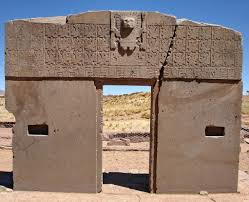
Some researchers, including Jim Allen, have studied Tiwanaku’s remarkable Gate of the Sun and identified the figures carved on it as a sophisticated calendar(v).
A paper from Marco Antonio Cabero regarding the ‘Gate’ throws a modicum of doubt on its possible use as a calendar. Instead, he focused on the other side of the monument where he claims there is evidence that the ancient people of Tiwanaku knew the ‘golden number’, phi.
“The composition of the front face of the Gate of the Sun in Tiwanaku presents, anthropometric, and bilateral symmetry. On the back side, there are also harmonic proportions but with less significance. These proportions were not found before because the study of the content of its engraving frieze was believed to be a calendar, an idea that has been so widely extended, that any other interpretations were ignored (however, the presence of these proportions does not exclude the possible existence of some type of calendar). The Gate of the Sun may not be part of a temple, but its content could also be considered as the expression of a monument in itself; a work that testifies to the importance of knowledge, art, and science “(ac).
Ashley Cowie has recently proposed that Tiwanaku was located on an ancient Prime Meridian(w).
Also eye-catching is the claim(l) by Roger Elefant that later construction at Tiwanaku was carried out by the Vikings!
However, a more recent, but catastrophic, explanation is offered by Stephen Smith(d) on the Thunderbolts.info website. Perhaps Smith’s ideas might be combined with the studies of George Dodwell to produce a more comprehensive hypothesis. Posnansky’s date is greatly at variance with conventional dating that puts the flourishing of Tiwanaku from 1200 BC until 1200 AD. The latter part of that period roughly coincides with the existence of the Wari Empire, a possible rival of Tiwanaku(e).
In 2013, Jason Yaeger and Alexei Vranich published a detailed study of the chronological development of Tiwanaku and Puma Punku. This is now available on the Academia.edu website(ao). Anyone seeking support for ancient astronauts, giants or Atlantis will be greatly disappointed. The authors confirmed a starting date for monumental construction at the site of no earlier than 200 BC, which continued intermittently until the arrival of the Spanish invaders. Their report is the result of the ‘hard slog’ required by real archaeology.
Several claims attempting to link Tiahuanaco with Atlantis have been made, with one anonymous blog(y) insisting that it was the capital of Atlantis. James Bailey was an early advocate [149] of a Peruvian Atlantis with its capital at Tiwanaku or Chan Chan, which was probably the largest pre-Colombian city in South America.
The claim of a direct connection between Tiahuanaco and Atlantis is hard to accept on a number of grounds; for example, the idea of an army travelling from the west coast of South America to attack Greece in the east of the Mediterranean is not tenable. That there was an advanced culture in the Andes is undeniable but to link it to Plato’s story is stretching credibility to extremes. Lake Titicaca and Tiahuanaco have plenty of mysteries still to be explained. In 1980 the Bolivian scholar, Hugo Boero Rojo, aided by one of the local natives, Elias Mamani, located underwater ruins off the coast of Puerta Acosta[576]. His discoveries included megalithic temples, flights of stairs and stone roads.
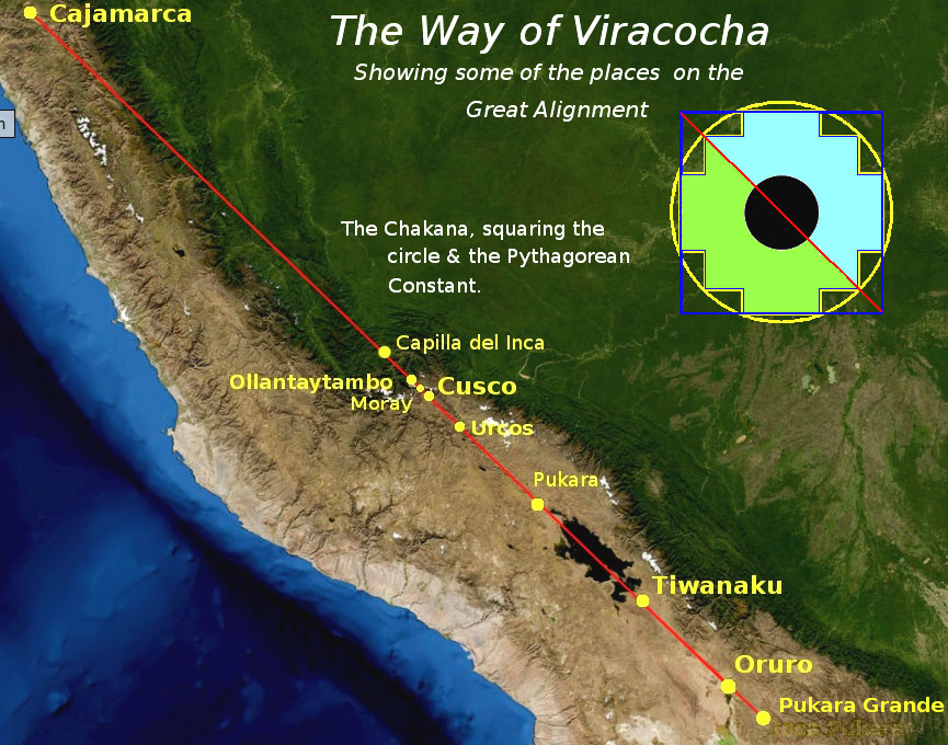 More recently, Dave Truman has written about an alignment known as ‘The Way of Viracocha’ that runs from Cajamarca in the north, through Cuzco and Tiwanaku and finishing at Pukara Grande(p), oriented exactly 45° west of true north. Truman has built on the work of Maria Sholten d’Ebneth (1926-2007), who wrote of the La Ruta de Wiracocha[1236] in the 1970s(q). Others have expanded on her work, but usually in Spanish. Truman has speculated on whether “Viracocha, the great teacher and restorer of civilisation in the Andes, in some way embodied the scientific knowledge of a sophisticated, but long-forgotten high culture?”Truman also discusses the ‘chakana’ or Andean stepped cross (see left) and its possible meaning.
It was reported in October 2013(g) (that a team of Belgian and Bolivian archaeologists had found an assortment of ceramics, gems and gold objects at an apparent ceremonial site beneath the waters of Lake Titicaca, which was sacred to the Incas and Tiwanakus. It was not until 2019 that images of some of the artefacts recovered from the lake were widely published(x).
We cannot leave the matter of mysterious Tiahuanaco without referring to the fact that some miles further south is Lake Poopó beside which Jim Allen is convinced that the city of Atlantis was located. Allen claims that the large plain to the west of the lake is the plain mentioned by Plato as being adjacent to the city of Atlantis. In a recent documentary “Atlantis in the Andes” broadcast by ‘Discovery Civilization’, Allen identified Tiahuanaco as one of the ten kingdoms of Atlantis. However, I cannot help noticing that while Tiwanaku, claimed to be 17,000 years old, provides us with an astonishing wealth of structures and finely dressed stone, Allen’s chosen Atlantis site, Pampa Aullagas, offers little more than rubble!
Another supporter of an Andean Atlantis is Sean Bambrough, who has been developing a theory since 1999 that identifies Tiwanaku as the city of Atlantis(h). He has now published his magnum opus on the academia.edu website(ae).
In February 2015, Marcelo Ozorio also suggested a link with Plato’s Atlantis and most interesting is the huge number of images included on his site(i). There is also a large collection of related images on a YouTube clip(m).
In 2022, Marco Vigato‘s book, Empires of Atlantis [1830] was published, which included Tiwanaku as part of the evidence for his hyperdiffusionist Atlantis(ab).
In 2008, David E. Flynn brought to public attention an astonishing series of satellite photos(a) that show a vast network of the remains apparently of man-made structures that extend for many miles around Lake Titicaca. These ‘geoglyphs’ encompass Tiahuanaco.
The most remarkable collection of early photos of the Tiwanaku site can be found on the Above Top Secret website(b). The accompanying text makes a strong case for treating the location as archaeologically contaminated and as a consequence that many of the dates proposed for the site should be considered suspect. Other mysteries are the fact that saltwater Lake Titicaca contains known sea life and that old waterlines are slanted(c).
In late March 2015, the Bolivian government announced(j) that ground-penetrating radar had identified what appeared to be a buried pyramid in the Tiwanaku complex as well as other ‘anomalies’ and that excavations may start in May or June.
A mixed Spanish and English website(f) offers a number of interesting papers including a chapter from Posnansky’s book Tiahuanaco: The Cradle of American Man.
Archaeology magazine has an interesting Q & A paper relating to the history and current state of preservation at the Tiwanaku site(s).
A May 2017 report(r) confirmed that the entire Tiwanaku complex is much more extensive than previously thought, covering an area of at least 650 hectares (1,675 acres).
Joseph Davidovits who controversially proposed that Giza’s Great Pyramid stones had been cast rather than carved has also claimed that other well-known structures had been created in a similar manner, such as at Tiwanaku and Puma Punku in Bolivia(ah) and Easter Island(ai). He offers scientific evidence to support this claim in a very interesting video(ak). My objection to his ‘cast rather than carved’ hypothesis, particularly in relation to Easter Island, is that partially finished statues are visible today in a quarry still attached at the back to the rock from which they were carved as well as some of the tools used for the job. Images of these can be seen in Thor Heyerdahl’s Aku-Aku [1938].
Brien Foerster is an American writer who now lives in Cuzco, the former Inca capital in Peru. He has studied the ancient cultures of the Andes and believes that many predated the Incas and had advanced technologies that permitted the precise drilling of stone(af), the quality of which he has compared with examples found in Egypt and like Chris Dunn concluded that their level of accuracy could not have been achieved without possession of a high technology, now lost(ag). He has expanded on this in his 2014 book, Lost Ancient Technology of Egypt [1487].
A fully illustrated guide to the intriguing monuments of Tiwanaku/Puma Punku is now available which is an excellent introduction to the site including a map by Javier Escalante Moscoso(an).
(a) https://www.freerepublic.com/focus/f-chat/1977971/posts
(b) Tiahuanaco, Puma Punku the real mystery…, page 1 (archive.org) *
(c) https://www.thunderbolts.info/wp/2012/04/30/tiwanaku/
(d) https://www.thunderbolts.info/wp/2013/04/03/tiwanaku-3/
(e) http://www.sci-news.com/archaeology/science-wari-tiwanaku-rival-empire-01473.html
(f) https://www.bibliotecapleyades.net/arqueologia/esp_tiahuanaco5.htm
(h) https://2rbetterthan1.wordpress.com/atlantis-south-americatiahuanaco/
(i) Tiwanaku, pre-columbian archaeological and world heritage site at Bolivia (viagem.space)
(l) https://atlantide-mu.over-blog.com/2013/12/terre-creuse.html
(m) https://www.youtube.com/watch?v=PkuoXm9uafI (unavailable)
(n) The age of Tiwanaku (Tiahuanaco) Site, Bolivia (archive.org)
(o) See: https://web.archive.org/web/20170601230717/https://www.atlantisquest.com/prehistcity.html
(p) https://grahamhancock.com/trumand1/
(q) https://puri-aprendiendovida.blogspot.ie/2013/02/la-ruta-de-viracocha-camino-de.html
(s) https://interactive.archaeology.org/tiwanaku/qanda.html
(t) https://archive.archaeology.org/blog/the-fantasy-world-of-tiwanaku/
(u) https://theappendix.net/issues/2013/4/andean-atlantis-race-science-and-the-nazi-occult-in-bolivia
(v) https://blog.world-mysteries.com/science/the-gate-of-the-sun-calendar-from-ancient-tiwanacu/
(w) https://www.ancient-origins.net/events/unearthing-lost-meridian-tiwanaku-s-temple-builders-0010322 (link Broken)
(y) https://grahamhancock.com/phorum/read.php?1,1063585,1063585#msg-1063585
(z) https://web.archive.org/web/20161107001948/https://www.atlantisquest.com/prehistcity.html
(aa) https://www.oocities.org/debunkinglc/tiwanaku.html (link broken)
(ab) https://www.amazon.com/Empires-Atlantis-Civilizations-Traditions-throughout/dp/1591434335
(ad) (PDF) Mathematics in Tiwanaku-The gold number in the gate of the sun (researchgate.net)
(ae) https://www.academia.edu/61088843/Atlantis_Found_in_the_Andes_by_V_Sean_Bambrough
(af) https://www.youtube.com/watch?v=xR7of1Lkef0
(ag) https://ahotcupofjoe.net/
(ah) https://www.geopolymer.org/archaeology/tiahuanaco-monuments-tiwanaku-pumapunku-bolivia/
(ai) https://www.geopolymer.org/library/video/they-came-from-america-to-build-easter-island/
(aj) QC2K – Neil Steede (archive.org)
(ak) https://www.geopolymer.org/library/video/they-came-from-america-to-build-easter-island/
(am) (99+) 2007 Chapter 3 Tiwanaku.doc | Graham Holton – Academia.edu
(an) Tiwanaku, the mysterious pre-Inca capital – mapaymochila.es
(ap) Tiahuanacu, The Mysterious City (archive.org)
(aq) https://www.hallofmaat.com/methodological/an-answer-to-graham-hancock/