Latest News

Joining The Dots
I have now published my new book, Joining The Dots, which offers a fresh look at the Atlantis mystery. I have addressed the critical questions of when, where and who, using Plato’s own words, tempered with some critical thinking and a modicum of common sense.Read More »
Philip Coppens
Nile River
 The River Nile was considered the longest river in the world, a title now disputed by the Amazon.(a) More important was the part it played in the development of pharaonic Egypt. Understandably, it also played a part in the mythology and religion of ancient Egypt.
In 2019, a paper(d) by Larry Pahl revisited the Orion Correlation Theory and argued that Robert Bauval should not have limited his theory to Orion’s Belt alone, but should instead have considered the entire constellation and explored a broader reflection on the monuments of ancient Egypt. Prahl then proceeds to do exactly that.
Similarly, Jean-Pierre Lacroix claimed that other Egyptian structures may have been located to reflect the layout of other constellations in the sky. Specifically, he focuses on Aries and Thebes(e) .
Alessandro Berio went further with the claim(f) that the entire Nile was ‘designed’ to be a reflection of the constellations above!
Philip Coppens, commenting on how the Incas viewed the valley of Cusco, wrote, “Modern research suggests that the Sacred Valley of the Vilcamayu and Urubamba rivers symbolised the Milky Way. Identifying rivers with constellations, specifically the Milky Way, is nothing new. Other examples are the Nile, as well as the Po in Italy and the Rhône in France.”(b)
Derek Cunningham claims to have discovered(c) that there is an association between the layout of the Stonehenge complex with the Milky Way!
(a) Nile – Wikipedia
(b) Viracocha’s voyage – Eye Of The Psychic
(c) http://web.archive.org/web/20200702025539/https://atlantipedia.ie/samples/archive-3055/
(d) https://www.academia.edu/41868838/Expanding_the_Orion_Correlation_Theory_OCT_
Patriarchs and Longevity
The Patriarchs referred to in Genesis and their seemingly exaggerated longevity has been a source of continuous debate ever since biblical criticism developed in the 18th century. Cornelius de Pauw referred to the apparently exaggerated life spans of the biblical patriarchs, explaining that it was widespread in the Middle East and further afield to name a dynasty or family after its founder and attribute the total years of its reign to that founder. [1756.258]
Charles N. Pope claims that “the Patriarchs listed in the Book of Genesis are one and the same as the great ‘God-Kings’ of the ancient world(m).”
Before dePauw, Pierre-Daniel Huet expressed similar views to Samuel Borchart, linking the biblical patriarchs and the story of Atlantis in his Demonstratio Evangelica [1007]. Atlantology’s interest in the apparent longevity of the patriarchs stems from the difficulty created by Plato’s insistence that Atlantis was at war with Athens and Egypt 9,000 years before Solon’s visit to Egypt. This idea defies reason as neither state existed until many millennia later. An astounding number of attempts to reconcile this large discrepancy are on offer (See Dating Atlantis).
Stephen E. Jones published an interesting paper in 2005, whose investigation led him to conclude “there is no real conflict on this matter between the Bible and science nor between the Bible and itself”(i). Carol A. Hill has written a paper, Making Sense of the Numbers of Genesis, also intended to reconcile the Ages of the biblical patriarchs and science(j) as was a paper by Jim Stump(k). (See below)
Lee McKague has suggested that there may be a biological explanation for the longevity of the biblical patriarchs(h)!
Emilio Spedicato in a paper(f) entitled Large Numbers in Asian Chronology Decrypted includes some radical ideas on how to resolve the mystery of the ages of the patriarchs recorded in the Bible. He also expanded on his ideas regarding large numbers in ancient chronologies with a paper(l) in which he considers “large numbers in days, not in years, that appear in Mesoamerican Mayan and Toltecs chronologies. We show how such numbers, when reduced to years under some hypotheses, provide important information for a period extending over several thousand years BC, related to catastrophic events on our planet and to a special event in the solar system.”
A paper(a) by an unnamed and apparently deceased author was published by Duane L. Christensen. It approaches the ages of the patriarchs from a numerological standpoint with some curious conclusions. I’m wary of all such occult claims but will leave it to readers to decide.
Over a century ago, George H. Cooper offered the simplistic suggestion that the great ages of the patriarchs, recorded in the Bible were the result of confusing lunar cycles with solar years [236.232]!
Zoltan Simon has claimed that the ages of the patriarchs were calculated using 90-day ‘years’ [0549.7].
Another paper by Dean Talboys, entitled Methuselah Debunked(b)(c)(d) offers a convoluted explanation for the ages based on Babylonian astronomy/astrology.
Philip Coppens has also touched on a possible astronomical explanation for the patriarchal numbers(g).
In one(e) of his many papers on ancient chronology, Gérard Gertoux he controversially touches on subjects such as radiocarbon dating, the age of the patriarchs, the Ice Ages, evolution and more.
Readers interested in the attempts to explain the apparently inflated ages of the patriarchs might like to tackle a paper, by Jim Stump, on the biologos website, where it proposes that “One option is attaching some significance to the fact that all of the 30 numbers can be expressed as combinations of the two “sacred” numbers 60 and 7 in terms of years and months. 60 was culturally significant because it was the number that Babylonian mathematics was based on (the influence of this sexagesimal system is still felt today with our 60 minutes per hour and 60 seconds per minute). And 7, of course, has a prominent place in biblical symbolism beginning with the Sabbath. So when we’re told that Methuselah was 187 years when he had his son Lamech (Gen. 5:25), we can see that 187 = 60+60+60+7 years. And then because 60 months = 5 years, when Adam is said to be 130 years at the birth of his son Seth (Gen. 5:3), that can be expressed as (60+60 years) + (60+60 months).” (k)
(a) The Mysterious Numbers of the Ages of the Patriarchs (jbburnett.com)
(e) https://www.academia.edu/17026643/Noah_and_the_Deluge_Chronological_Historical_and_Archaeological_Evidence (around one-third of the page down)
(f) Migration & Diffusion (migration-diffusion.info)
(g) https://www.eyeofthepsychic.com/genesis5/
(h) https://www.researchgate.net/publication/253528140_Methuselah_Oldest_Myth_or_Oldest_Man
(i) Stephen E. Jones: Projects: The ages of the patriarchs in Genesis 5 and 11 (archive.org)
(j) https://www.asa3.org/ASA/PSCF/2003/PSCF12-03Hill.pdf
(k) https://biologos.org/articles/long-life-spans-in-genesis-literal-or-symbolic
(l) Wayback Machine (archive.org) *
(m) http://www.domainofman.com/book/abstract.html
Jeffries-Fox, Bruce
Bruce Jeffries-Fox is an American musician, who recently completed a musical based on the content of Sumerian cunieform tablets. influenced by the writings of Zechariah Sitchin!
His Enduring Mysteries website contains a number of interesting essays on ancient history subjects, which includes two(a)(b) devoted to the possibility of Atlantis in France, based on the ideas of Marcel Mestdagh and Philip Coppens’ book, The Lost Civilization Enigma [1275].
Geodesy
Geodesy is usually defined as the measurement and mapping of the Earth. James R. Smith, the author of Introduction to Geodesy [1947] has conflated several definitions to produce “Geodesy, from the Greek, literally means dividing the earth, and as a first objective, the practice of geodesy should provide an accurate framework for the control of national topographical surveys. Thus, geodesy is the science that determines the figure of the Earth and the interrelation of selected points on its surface by either direct or indirect techniques. These characteristics further make it a branch of applied mathematics, one that must include observations that can be used to determine the size and shape of the earth and the definition of coordinate systems for three dimensional positioning; the variation of phenomena near to, or on the surface, such as gravity, tides, earth rotation, crustal movement, and deflection of the plumb line; together with units of measurement and methods of representing the curved earth surface on a flat sheet of paper.”
Geodesy as a science can be traced back to Pythagoras (6th cent. BC), who was thought to be the first to propose the sphericity of the Earth. Aristotle & Archimedes were apparently the first to offer a figure for the diameter of the Earth, suggesting 400,000 and 300,000 stades, respectively. The difference might be partly explained by the use of a different length of stade.
Later, Eratosthenes (276 BC– 195 BC) offered another early attempt to determine the dimensions of our Earth and succeeded with remarkable accuracy.
A controversial aspect of modern geodesy is the claim that many ancient sites were deliberately established at locations that had a specific geodetic relationship to each other and/or the dimensions of the Earth. For example(a) in ancient Egypt, the distance from Giza to the Equator was calculated to be 1/12th the circumference of the Earth, Amarna to the Equator is 1/13th, Luxor 1/14th and Philae 1/15th!
Graham Hancock in his Heaven’s Mirror[855] pointed to similar relationships around the globe, suggesting a possible world grid. This idea of a world grid has a number of supporters, but is often classified as a ‘fringe’ interest, due to the attempt by some to link gridlines with UFOs and their use of the grid as a power source(w). Hancock’s various claims regarding the dimensions of the pyramids and their association with a suggested world grid has been challenged in great detail by a Hall of Maat article by Thomas W. Schroeder(ah). He concluded that “Graham Hancock’s assertion that the Great Pyramid’s dimensions reveal knowledge of earth’s dimensions certainly lacks proof but also fails to hold up to any scrutiny as a viable theory. Each step argued by Hancock; that the Great Pyramid was built to a specific scalar, that the value of the scalar can be definitively demonstrated, that the scalar indicates precession, that the only way ancient Egyptians could estimate precession is to leverage or borrow knowledge from earlier advanced and unrecognized civilizations, are each filled with flaws when taken individually, let alone when strung together to complete his narrative.”
The idea of a global grid has been pursued by a number of investigators, often with conflicting results. In the 1980s, William Becker and Bethe Hagens, published their widely referenced Planetary Earth Grid(aj). They “discussed the code of the Platonic Solids’ positions on Earth, ascribing this discovery to the work of Ivan P. Sanderson, who was the first to make a case for the structure of the icosahedron at work in the Earth. He did this by locating what he referred to as Vile Vortices refer to a claim that there are twelve geometrically distributed geographic areas that are alleged to have the same mysterious qualities popularly associated with the Bermuda Triangle, the Devil’s Sea near Japan, and the South Atlantic Anomaly.”(ak)
Possible related features may be the ley lines identified by Alfred Watkins in Britain(c)(g), the Alesia alignments in France discovered by Xavier Guichard(b) and/or the Heilige Linien of Germany, claimed by Wilhelm Teudt(aa) and supported by Henrich Himmler.
Xavier Guichard (1870-1947) is described as a Paris police chief and philologist. Between 1911 and 1936, he carried out an extensive study of French place-names and found that there were at least 400 sites with names derived from Alesia. When mapped, these hundreds of sites all lay on lines radiating from today’s town of Alaise, reminiscent of Alfred Watkins leylines! Francis Hitching, in The World Atlas of Mysteries [307.78] tells of how Guichard self-published his book, only to have his home bombed during the war in 1945, killing him and destroying most copies of his book. Elsewhere(b) the year of his death is given as 1947! Hitching included two maps reconstructing Guichard’s work.
Ashley Cowie has published a paper(ac) related to Alesia and the work of Guichard and others, as well as his own investigations.
Heinz Kaminski claimed to have discovered a megalithic grid system that stretched from Stonehenge across Europe with an east-west and north-south orientation and referred to as the Stonehenge/Wormbach System(h).
Even more exotic is the ancient Raetiastone navigation system rediscovered by Gerhard Pirchl (1942-2013) and outlined in a book by [1831] Thomas Walli(ae).
I should point out that Marcel Mestdagh also identified a form of a road system, laid out in giant ovals with radials in France. At the centre of these ovals was the ancient city of Sens. Philip Coppens informs us [1275.184] that a further strange discovery by Mestdagh, was that this ancient road network, centred on Sens, was mirrored by a similar network of roads in England, centred on Nottingham!
‘The Way of Virachoca’ in the Andes, which runs through Tiwanaku and is oriented exactly 45° west of true north and runs for over 1000 miles, it has been studied by Maria Scholten d’Ebneth [1236] in the 1970s and expanded on by a number of Spanish speaking commentators and is now the subject of an article by Dave Truman(x).
In 1973, three Russians, engineers Valery Makarov and Vyacheslav Morozov, along with Nikolay Goncharov, an artist, published an article in Russian with the eye-catching title of, Is the Earth a Giant Crystal? (y) This was probably the earliest presentation of an earth grid based on ancient historical sites. A brief history of the Earth grid theories that emerged around this time is available online(z). There is now a Russian geodesy website with an English translation(ab).
David Hatcher Childress published his Anti-Gravity and the World Grid [1303] in 1993, with the modest claim that he “proves that the earth is surrounded by an intricate electronic grid network offering free energy.” Obviously, Childress’ understanding of ‘proof’ is different to mine, as the only proof required is the production of some of this free energy, which he has not done.
Tom Brooks(ai) entered the fray with a study of 1500 prehistoric sites and his conclusion that the inhabitants of ancient Britain had designed a navigation system based on a grid of isosceles triangles(i). Brooks has gone a step further and speculatively claimed that the accuracy of this geometry-based system could only have been designed through “extraterrestrial intervention”(r). This concept is explored more fully in his latest book, Seeing Around Corners: Geometry in Stone Age Britain [863] and in a series of video clips(s). A more critical view of Brooks’ ideas is also available on the Internet(j).
Some years ago, a former employee of a NASA sub-contractor, Maurice Chatelain, claimed that within a 450-mile radius of the Aegean island of Delos, 13 mystical sites, when connected by straight lines formed a perfect Maltese Cross(u)!
Others such as Livio Stecchini(d) and Jim Alison(e) using geodetic calculations, have identified São Tomé and Cape Verde, respectively as the location of Atlantis. I must also include Hugo Kennes, a Belgian researcher with a passionate interest in global grids and sacred geometry(l). Kennes has also informed me of a new Facebook group(q) which deals with all aspects of the subject, as well as another(v) that includes submerged cities and other features.
Anyone interested in pursuing a study of this subject might like to look over James Q. Jacobs’ archaeogeodesy website(f) as well as the BioGeometry website (m).
If you have pursued all the links so far, you can pamper yourself further with a paper(k) by William Becker and Beth Hagens(n). Another researcher in this field is Dan Shaw, whose website(o) gives a good overview of the subject.
Jean-Pierre Lacroix added his weight to the debate with his 1998 paper entitled, The Mapmakers from the Ice Age(t).
A global network of sacred sites was also put forward by Rand Flem-Ath & Colin Wilson in, The Atlantis Blueprint [063]. This book was intended as a sequel to, When the Sky Fell [062], but it generally wandered off into other areas after the first couple of chapters.
I am somewhat sceptical about certain aspects of geodesy, particularly some of the claims of a world grid. However, it does raise many questions that require further study and explanation. In this connection, I would recommend John Sase’s, Curious Alignments [1589] as a good starting point. He confirms the work of Guichard and also offers a range of his own discoveries in the Great Lakes region.
In February 2020, Frank Maglione Nicholson, Ken Phungrasamee & David Grimason, collectively known as The Nazca Group(ad), published, The Nazca Great Circle Map Hypothesis. Their claim is that “The lines and geoglyphs carved into the Nazca plateau represent a map of the Earth. The map is a Great Circle Map: a gnomonic projection, with the center of the Earth as its cartographic viewpoint. Each line on the Nazca Plateau represents a great circle of navigation centred at the centre of the Earth and encircling the entire planet. The majority of the lines on the Nazca Plateau radiate from five loci of origin called radial centres.” I found this rather esoteric proposition difficult to absorb.
Arturo Villamarin has published many books [1864] and papers(af)(ag) in which the geometry and astronomy of archaeological monuments; Göbekli Tepe, Stonehenge, Teotihuacán and Mohenjo Daro, among others, are discussed.
(a) http://www.ancient-wisdom.com/geodesy.htm
(b) http://www.ancient-wisdom.com/xavierguichard.htm
(c) http://www.ancient-wisdom.com/leylines.htm
(d) http://www.metrum.org/mapping/atlantis.htm (link broken Dec. 2020)
(e) http://home.hiwaay.net/~jalison/concl.html
(f) https://web.archive.org/web/20200917015056/http://www.jqjacobs.net/index.html
(g) https://liminalthresholds.blogspot.ie/2008/04/earth-energy-ley-lines.html
(i) See: https://web.archive.org/web/20160628154229/https://www.prehistoric-geometry.co.uk/
(j) https://www.badscience.net/2010/01/voices-of-the-ancients/
(k) https://www.bibliotecapleyades.net/ciencia/antigravityworldgrid/ciencia_antigravityworldgrid02.htm
(m) https://web.archive.org/web/20170328094319/https://www.biogeometry.org/page34.html
(n) Bethe Hagens – Geometry, Anthropology anf the Arts of Consciousness (archive.org)
(o) https://www.vortexmaps.com/grid-history.php
(q) https://www.facebook.com/groups/175027289350368/
(r) https://www.prehistoric-geometry.co.uk/ [See (i)]
(s) https://www.youtube.com/watch?v=R35A80kV0AU&feature=relmfu
(t) https://ancientcartography.net/geoAN.html
(u) https://www.mail-archive.com/ctrl@listserv.aol.com/msg28306.html
(v) https://www.facebook.com/groups/493298404177687/
(x) https://grahamhancock.com/trumand1/
(y) http://web.archive.org/web/20220819135530/https://atlantipedia.ie/samples/archive-3193/
(z) https://www.vortexmaps.com/grid-history.php
(aa) https://www.cantab.net/users/michael.behrend/repubs/teudt_hl/pages/index.html
(ac) Solstice Axis Of The Ancient Gauls — ASHLEY COWIE (archive.org)
(ad) The Nazca Solution – The final solution to what the Nazca Lines represent (archive.org)
(ae) https://www.megalithic.co.uk/article.php?sid=2146413597
(ag) (99+) (PDF) THE GEOMETRY AND ASTRONOMY OF GOBEKLI TEPE | Arturo Villamarin – Academia.edu
(ai) https://www.megalithic.co.uk/article.php?sid=2146413745
(aj) Microsoft Word – antigravity.doc (montalk.net)
(ak) https://www.crystalinks.com/grids.html
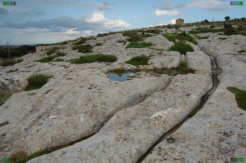
Cart-Ruts
The Cart Ruts of Malta are one of the many remarkable archaeological features of the archipelago. Unfortunately, the local authorities have not done all they could to ensure their preservation. Cart ruts are also found in other countries, but with nothing like the numbers found in Malta.
Sardinia has a number of comparable cart ruts that have only recently received the attention they deserve. Dr Dominique Görlitz has studied these cart ruts(ai). Images of the Sardinian ruts can also be seen in a YouTube video(aj).

Madeira taxi sleds
An article written in 1904(h), describes a visit to the Madeiras where the writer travelled on a sled drawn by oxen, While Alexander Braghine describes how Paul le Cour visited the Azores and noted that the natives there used ‘sledges’, rather than wheeled vehicles and greased the runners to assist movement, similar to the practice on the Madeiras. A more recent paper(s) by Félix Rodrigues, of Azores University, discusses in detail, cart ruts found on Terceira Island in the Azores. Other papers(w)(x) on the Academia.edu website, discuss ‘ruts’ on Lanzarote, in the Canaries.
Uwe Sneider, has produced the most comprehensive overview of the geographical distribution of cart ruts that I have encountered(ak). He has visited many of the sites in the Mediterranean and across Europe and furthermore, has alluded to possible traces of ruts on other continents.
An image (4th down) from Malta, on a 2017 posting(af), appears to show where axles have worn into a raised stone wall at one side of a rut, which would seem to end the ‘sledge versus wheel’ controversy.
Another feature of the ruts found in Malta, is the inexplicable manner in which some will suddenly disappear at cliff edges and furthermore, ruts are also found disappearing into the sea on one side of a bay and then reappearing on the opposite side. Over a century ago, Emanuel Magri, reported that there were cart ruts on the tiny island of Filfla, which lies 5km off the south coast of mainland Malta, suggesting the disappearance of a very large tract of land between the two and possibly beyond.
The melitamegalithic website has linked the altered orientation of Malta’s temples, with the geological disruption indicated by the cart ruts (ae) noting that, “While the geology of the Maltese islands indicates unmistakably major events of a cataclysmic nature, these give little hint as to what took place, and when. What is definitely obvious is that the geologic events are evident from man-made artefacts. Those artefacts point to the kind of event and the time when it occurred. In geological time they are quite recent.”
“The earliest reference to cart-ruts was made by Gian Francesco Abela (1582–1655) in 1647 [1676] who suggested that they were used to transport stones from quarries to the sea for exportation to Africa during the Arab rule in Malta.”(z)
Dr David Trump, (1931-2016) who has done much to advance Maltese archaeology, published a booklet on the cart-ruts in 2008 [658]. Trump nicknamed the complex collection of ruts at Misrah Ghar il-Kbir “Clapham Junction” after the London railway station, where several railway services interchange. A 1998 paper(d) by Joseph Magro Conti and Paul C. Saliba, focused on “Clapham Junction” and concluded that the ruts had a clear connection with the transportation of material from adjacent quarries.
Speaking of railways, Ralph Ellis has written on the suggestion that the standard British railway gauge, may have had its origins in the cart ruts of Malta, or ancient Egyptian cubits!(ag)
A detailed study of the morphology of the Maltese cart ruts was published in the Journal of Archaeological Science in 2022, concluded that, although there are some exceptions, “it is arguably the case that the data do suggest that ruts are fairly standardised” (an).
A connection between the cart ruts and Atlantis has been suggested by Anton Mifsud and adopted by the late Axel Hausmann, who both claim that the ruts were the irrigation channels referred to by Plato (Critias 118c-e).
Another prominent archaeologist, Claudia Sagona, has also suggested(f)(j) that the ruts were used for irrigation, although she has not associated them with Plato’s text. While this linkage fits nicely with the theory of Atlantis having been in the region of Malta, it does not stand up to close examination.
First of all the cart ruts follow the natural undulations of the Maltese landscape and so to function as irrigation channels, would require water to flow uphill for parts of its journey, Trump has mentioned how some of the ruts can be seen sloping as much as 45°. Roman aqueducts, like the one in Malta’s Rabat(ac)(ad), seldom used a gradient greater than half of one percent.
Secondly, the fact that the ruts are always found in pairs would suggest a degree of unnecessary and wasteful duplication found in no other irrigation system in the world. Because; if the ruts were intended to carry water, for the same labour they could have been cut as a single channel at twice the depth, cutting losses through evaporation by half.
As well as that, the ground between each pair of tracks could provide an extra acre of arable land, for every two miles of length. Furthermore, the multiplicity of tracks at the ‘Clapham Junction’ site is incompatible with an irrigation system.
All of which is compounded by the absence of controlling sluicegates anywhere at the remaining 100+ sites, and emphasised by Trump’s observation that “no association of ruts with water sources has been demonstrated.”[870.268]
I refer below to several countries where comparable cart ruts have also been found. I am not aware of even one instance where any of these have been suggested as having an irrigation function.
Compounding all that, is the fact that no supporter of the cart ruts as Plato’s irrigation channels has attempted to explain how the dimensions of the ruts can be measured in inches, while Plato describes canals measured in feet – tens of feet!
Joseph S. Ellul in his book Malta’s Prediluvian Culture [0289] expressed some controversial unconventional views(t) regarding the cart-ruts, including his assertion that the ruts were created by tools or machinery and were formed during the Stone Age, before the biblical Deluge! A chapter from his book focussed on the cart ruts has been translated(ah) into German and published by Atlantisforschung. With the help of Google Translate, I have added an English text below(ao).
Graham Hancock refers to the cart ruts several times in Underworld [274], where he commented that “It is certain, too, that they were not simply worn away in the tough limestone by the passage of cart-wheels over periods of centuries, as many have wrongly theorized; on the contrary, there is no proof whatsoever that cart-wheels ever ran in these ruts – which were initially carved out of the bedrock with the use of tools.” [p.331] His claim that the ruts were hand-carved is disputed by Gordon E. Weston in his excellent book [754.172] debunks the idea.
Philip Coppens wrote a paper on the ruts, offering an overview of the controversies relating to their use and date(aa).
By way of comic relief, I thought I should include one theory regarding an explanation(c) for the ruts from Laura Knight-Jadczyk, a noted conspiracy theorist, which I quote in full: “Do I have an idea to propose? Of course I do. I wouldn’t be writing about it if I didn’t. I would like to suggest that these “ruts” look an awful lot like places where lightning has struck, and the electricity has blasted away the dirt and rock as it shoots along some sort of natural earth power grid conductor. The only difference is that the cart ruts are not random. That suggests that there was something present in the ground laid out in a definite grid, which acted as a conductor. Were the cart ruts some sort of networked energy conduction system? Could some sort of element have been placed in the ground by an ancient civilization; something that conducted power to their homes the way our vulgar power poles and lines crisscross the landscape? And then, at some point in time, was the earth hit by such a surge of energy from some unknown source that these power “lines” melted the rock in which they were “strung?” Perhaps a surge of some kind of cosmic energy source? Maybe even the Electromagnetic pulse of a nuclear explosion? Maybe it was neither of these, but merely a massive overheating of the surface of the earth so that the conduction element and its insulating covering melted and was swept away?”
One of the more bizarre suggestions has been proposed by Markus Tutsch on the German EFODON website, that the parallel ruts were used in some way to distribute electrical power(q)!!!
Another amusing suggestion is offered by Dr Cornelius Niels Kopf who has proposed that “The Bronze Age traces on Malta and Gozo and many other parts of the then populated world, known as cart ruts, were sports facilities, and the area designated as ‘Clapham Junction’ was apparently the ‘stadium’ of Malta.” (r)
Just as unusual is the claim by Robert Schoch, or more correctly. his wife, Catherine Ulissey, who proposed that “the cart ruts of Malta were made in soft earth and then flash ‘fired’ (as if in a kiln) due to incoming plasma from a massive solar event.” (am)
 In 2010, the most comprehensive work on the ruts, that I’m aware of, was published by Gordon E. Weston[754]. Weston now has a website(g) where he discusses the ‘ruts’ further and provides additional links. Weston also published Clapham Junction: 3000 Years of Maltese Heritage, in 2015 [1619].
There are also several websites devoted to the investigation of these enigmatic features(a). One of them(m) offers a fine collection of images, including the one above, as well as a discussion on the origin, use, and questions raised by the Maltese cart ruts.
A study of the ruts by three geomorphologists at Portsmouth University, published in Antiquity, is a valuable addition to the literature on the subject(b). The authors “that the ruts could be caused by two-wheeled carts with a gauge of 1.40m carrying moderate loads. In wet weather the carts would gradually cut into the limestone and reach their ground clearance of 0.675m, causing the carriers to try another route – so there are plenty of them.”
Uwe Topper has written an extensive paper on cart ruts around the Mediterranean and beyond(i). He controversially theorised that the ruts were created when the limestone on which they were cut was ‘softer’!!!
A short April 2015 video clip(l) demonstrates how even a 20kg quarter-scale slide-car, can, with one pass, cut a 1mm groove into the soft Maltese limestone, near Sliema. A full-scale slide-car would be carrying 320 Kg.
Amateur archaeologists, Ronnie Gallagher and Abbas Islamov, have highlighted the existence of cart-ruts in the Gobustan peninsula of Azerbaijan (e).
In a 2014 article(k)(ak) on the Mysteria 3000 website, André Kramer drew attention to the cart-ruts discovered on Mallorca, the principal island of the Balearic archipelago.
Evidence exists for cart ruts in other countries in Europe, such as Switzerland, and much further afield, including South America(u). The same site makes two interesting points, (1) since the earliest carts probably lacked brakes, the repeated use of the ruts gave some small degree of control, and (2) without any obvious passing points, the ruts seem to indicate that they were limited to one-way traffic.
A 2001 paper by Guy Schneider, discusses cartruts found at ten sites in Switzerland, France and Germany(al). The author notes that “while the cart-ruts at these sites are generally ascribed to the Roman period, the research has revealed that most of the available evidence points to a more recent date. “The question of whether the sites concerned were deliberately cut or “the result of mechanical wear by the passage of carriages” is touched on by Schneider, who concluded “that the initial rut was an artificial groove of at least 4cm depth in order to provide an efficient guidance to the wheels right from the beginning. Secondary processes due to erosion and wear are then responsible for a continuing shape of the rut.”
In 2015, Russian geologist Alexander Koltypin, drew much media attention(o) when he claimed that comparable tracks in the Phrygian Valley of Turkey were dated to 14 million years ago and were created by an unknown civilisation. He also implied that the cart ruts of Malta had a similar origin! However, a quick look at his website(p) revealed him to have travelled well beyond the lunatic fringe.
I find it interesting that much more investigation of the Maltese cart ruts has been carried out by foreigners than by natives of the islands. A recent example is the inventory of ruts recently published by Monika I. Trinkler, a Swiss photographer, who has listed 717 pairs on Malta and 43 on Gozo Dec. 2020). Her interest in the Maltese ruts has now expanded into the identification of ruts throughout Central Europe(v).
Unfortunately, the date and function of the ruts are still sources of intense debate, particularly in Malta itself. In 2017, Anthony Bonanno published The Archaeology of Malta and Gozo [1665] in which he argued for a Roman, rather than a prehistoric date for the cart ruts. This runs counter to the opinion of many, particularly that of the late David Trump. In 2019, Anton Mifsud published a rebuttal of Bonanno’s claims, in a fully illustrated book entitled David’s Ruts [1666], published as a tribute to the work carried out by David Trump on Malta.
In August 2021, it was announced that some of Malta’s cart ruts were to be covered by a new airport roundabout(ab)! A comment is unnecessary.
(a) https://web.archive.org/web/20190102032648/https://cartruts.com/
(c) https://www.cassiopaea.com/cassiopaea/adventures247.htm
(d) Malta – cart ruts (archive.org)
(e) https://www.azer.com/aiweb/categories/magazine/ai103_folder/103_articles/103_cart_ruts.html
(f) Oxford Journal of Archaeology (Vol.23, Issue 1, p.45-60)
(g) https://cartrutanswers.com/index.html (offline 15/07/14)
(h) See: https://web.archive.org/web/20110616093830/https://www.oldandsold.com/articles09/travel-45.shtml
(i) http://www.ilya.it/chrono/pages/gleisedt.htm (german)
(j) https://www.stonepages.com/news/archives/000350.html
(k) Cart-Ruts auf Mallorca – Mysteria3000 (archive.org)
(l) https://www.youtube.com/watch?v=M4y2aLns5So
(m) Cart Ruts Malta – Maltas Cart Tracks – others aound the world (archive.org)
(n) https://web.archive.org/web/20250321062718/https://atlantipedia.ie/samples/archive-3036/
(p) Earth before the Flood: Disappeared Continents and Civilizations (archive.org)
(q) Wayback Machine (archive.org)
(r) https://web.archive.org/web/20250326081557/https://atlantipedia.ie/samples/archive-6308/ &
https://web.archive.org/web/20250315141117/https://atlantipedia.ie/samples/archive-6309/
(s) https://www.academia.edu/37215162/Dating_the_Cart-Ruts_of_Terceira_Island_Azores_Portugal
(t) https://web.archive.org/web/20050301092052/https://www.truegood.fsnet.co.uk/hagarq5.htm
(u) http://www.ancient-wisdom.com/cartruts.htm
(v) https://malta-cartruts.ch/
(z) http://www.ancient-wisdom.com/cartruts.htm
(aa) https://web.archive.org/web/20200420044822/https://www.eyeofthepsychic.com/cartruts/
(ac) ~~ Roman Aqueduct System at Rabat – Eugene P Teuma – Culture Malta Culture Malta (archive.org)
(ad) https://www.academia.edu/1819676/QANAT_SAQQAJJA_and_ROMAN_AQUEDUCT_SYSTEM_at_RABAT_MALTA
(ae) https://melitamegalithic.wordpress.com/2019/09/25/beyond-the-he*retic-reality/
(ag) https://cdn.preterhuman.net/texts/religion.occult.new_age/occult.conspiracy.and.related/Ellis,%20Ralph%20-%20Assorted%20Articles.pdf (see ‘Ancient Egyptian Railways’)
(ah) Cart Ruts – Mysteriöse Wagenspuren auf Malta – Atlantisforschung.de (German)
(ai) On the trail of the Cart Rut mystery – Atlantisforschung.de (atlantisforschung-de.translate.goog)
(ak) Cart-ruts – Eine Annäherung an ein archäologisches Mysterium (www-cartruts-de.translate.goog) (English)
(al) cart-ruts article.pdf (ancient-wisdom.com)
(am) https://www.robertschoch.com/memes.html
(an) https://www.sciencedirect.com/science/article/pii/S2352409X21004995
(ao) http://web.archive.org/web/20250614163556/https://atlantipedia.ie/samples/archive-7256/
Temple, Robert
Robert K. G. Temple (1945- ) is the American bestselling author of The  Sirius Mystery [735]+. In it he supports the idea of extraterrestrial influence on human cultural development, citing as evidence, the ‘knowledge’ of the Dogon people regarding the Sirius star system before verification by modern astronomy.
Temple’s claims were, in the main, based on the work of Marcel Griaule (1898-1956) and Germaine Dieterlen (1903-1999), published in The Pale Fox [1698].
In Gods of the New Millennium [006.109], Alan Alford described Temple’s evidence as ‘incontrovertible’!
Temple published a response to some of his critics, particularly Carl Sagan, with an open letter in 1997(l).
However, Temple’s ideas ha now come under further attack with the claim that Sirius C does not even exist(c). The controversy is still raging as the Bad Archaeology website demonstrates(d) as well as an article from the Armagh Planetarium website(e). The refutation of the Sirius ‘mystery’ was achieved through the fieldwork of anthropologist, Walter E. A. van Beek, among the Dogon, which produced no evidence to support Temple’s claims(h). He published his findings in a 1991 paper [1685] and it is worth noting that van Beek’s criticisms were aimed at fellow anthropologist, Griaule, rather than Temple.
The late Philip Coppens wrote two highly critical articles(i)(j) denouncing the Dogon story as ‘false mythology’. He cites the work of Van Beek and The Stargate Conspiracy [705] by Lynn Picknett & Clive Prince, which he felt completely demolished Temple’s claims. Over twenty years later the book has again been reviewed in an audio format(k).
Temple contends that this interaction took place between 5000 and 3000 BC and refers to that era as the ‘Contact Period’. He goes further and claims that these ‘visitors’ were responsible for the building of the Sphinx and the pyramids and that later efforts by the Egyptians to build other pyramids on the same scale failed. However, some of the Mayan pyramids are equally impressive although built later than the magnificent Giza monuments, Temple does not explain the source of the Mesoamerican structures.
In 2000, Temple published The Crystal Sun[928] in which he outlined the evidence for early optical science, including its possible use in the lighthouse at Pharos(f). The matter of ancient lenses is discussed online(g). 2013 saw the publication of Ancient Glass[1002] by Prof. Julian Henderson in which he pushes back the earliest production of crude glass to the middle of the third millennium BC. Temple has a degree in Oriental Studies and Sanskrit from the University of Pennsylvania. He has written a number of sometimes controversial books on various historical subjects(a). Jason Colavito has cast doubt on Temple’s academic credentials in a September 2012 blog(b). However, it was not until his 2010 book, Egyptian Dawn[736], that he touched on the subject of Atlantis. In it, he declared that the “true ‘Atlantis’ was the Atlantic Coastal civilisation of the megalith builders.” He further proposes that the story of Atlantis was concocted by those megalith builders “for consumption by the people of the Mediterranean, as a kind of disinformation campaign.” Temple has hinted that he may devote an entire book to the subject of Atlantis sometime in the future!
Temple’s next offering came in 2022 in the form of A New Science of Heaven [1959]. The promotional blurb claims the book is “a new, explosive study of plasma and its revolutionary implications for how we understand the universe and our place in it.” Some of us probably find the subject of plasma rather arcane, nevertheless, there is one suggestion in this book that might have relevance for all of us. Plasma pervades the universe and Temple puts forward the idea that it may be sentient, which sounds like an updated form of pantheism!
[735]+ Available online: https://www.researchgate.net/publication/242865509_The_Sirius_Mystery
(a) Professor Robert Temple (archive.org)
(d) Did the Dogon of Mali know about Sirius B? (archive.org)
(f) https://www.newdawnmagazine.com/articles/lost-technology-of-the-ancients-the-crystal-sun
(g) https://web.archive.org/web/20200212044246/http://www.ancient-wisdom.com/optics.htm
(h) https://www.jasoncolavito.com/blog/germaine-dieterlen-the-sirius-mystery-and-the-quest-for-truth
(i) https://web.archive.org/web/20251009043342/http://www.ufoevidence.org/documents/doc129.htm
(j) https://web.archive.org/web/20251009043348/http://www.ufoevidence.org/documents/doc134.htm
(k) The Stargate Conspiracy – The Saucer Life
(l) On the Sirius Mystery: an open letter To Carl Sagan … – Robert Temple (yumpu.com)
Troy
Troy is believed to have been founded by Ilus, son of Troas, giving it the names of both Troy and Ilios (Ilium) with some minor variants.
“According to new evidence obtained from excavations, archaeologists say that the ancient city of Troy in northwestern Turkey may have been more than six centuries older than previously thought. Rüstem Aslan, who is from the Archaeology Department of Çanakkale Onsekiz Mart University (ÇOMU), said that because of fires, earthquakes, and wars, the ancient city of Troy had been destroyed and re-established numerous times throughout the years.” This report pushes the origins of this famous city back to around 3500 BC(s).
The precise date of the ending of the Trojan War continues to generate comment. A 2012 paper by Rodger C. Young and Andrew E. Steinmann has offered evidence that the conclusion of the conflict occurred in 1208 BC, which agrees with the date recorded on the Parian Marble(ah). This obviously conflicts with the date calculated by Eratosthenes of 1183 BC. A 2009 paper(ai) by Nikos Kokkinos delves into the methodology used by Eratosthenes to arrive at this date. Peter James has listed classical sources that offered competing dates ranging from 1346 BC-1127 BC, although Eratosthenes’ date had more general acceptance by later commentators [46.327] and still has support today.
New dating for the end of the Trojan War has been presented by Stavros Papamarinopoulos et al in a paper(aj) now available on the Academia.edu website. Working with astronomical data relating to eclipses in the 2nd millennium BC, they have calculated the ending of the War to have taken place in 1218 BC and Odysseus’ return in 1207 BC.
The city is generally accepted by modern scholars to have been situated at Hissarlik in what is now northwest Turkey. Confusion over identifying the site as Troy can be traced back to the 1st century AD geographer Strabo, who claimed that Ilion and Troy were two different cities!(t) In the 18th century, many scholars consider the village of Pinarbasi, 10 km south of Hissarlik, as a more likely location for Troy.
The Hisarlik “theory had first been put forward in 1821 by Charles Maclaren, a Scottish newspaper publisher and amateur geologist. Maclaren identified Hisarlik as the Homeric Troy without having visited the region. His theory was based to an extent on observations by the Cambridge professor of mineralogy Edward Daniel Clarke and his assistant John Martin Cripps. In 1801, those gentlemen were the first to have linked the archaeological site at Hisarlik with historic Troy.”(m)
The earliest excavations at Hissarlik began in 1856 by a British naval officer, John Burton. His work was continued in 1863 until 1865 by an amateur researcher, Frank Calvert. It was Calvert who directed Schliemann to Hissarlik and the rest is history(j).
However, some high-profile authorities, such as Sir Moses Finley (1912-1986), have denounced the whole idea of a Trojan War as fiction in his book, The World of Odysseus [1139]. Predating Finley, in 1909, Albert Gruhn argued against Hissarlik as Troy’s location(i).
Not only do details such as the location of Troy or the date of the Trojan War continue to be matters for debate, but surprisingly, whether the immediate cause of the Trojan War, Helen of Troy was ever in Troy or not, is another source of controversy. A paper(ab) by Guy Smoot discusses some of the difficulties. “Odysseus’, Nestor’s and Menelaos’ failures to mention that they saw or found Helen at Troy, combined with the fact that the only two witnesses of her presence are highly untrustworthy and problematic, warrant the conclusion that the Homeric Odyssey casts serious doubts on the version attested in the Homeric Iliad whereby the daughter of Zeus was detained in Troy.”
The Swedish scholar, Martin P. Nilsson (1874-1967) who argued for a Scandinavian origin for the Mycenaeans [1140], also considered the identification of Hissarlik with Homer’s Troy as unproven.
A less dramatic relocation of Troy has been proposed by John Chaple who placed it inland from Hissarlik. This “theory suggests that Hisarlik was part of the first defences of a Trojan homeland that stretched far further inland than is fully appreciated now and probably included the entire valley of the Scamander and its plains (with their distinctive ‘Celtic’ field patterns). That doesn’t mean to say that most of the battles did not take place on the Plain of Troy near Hisarlik as tradition has it but this was only the Trojans ‘front garden’ as it were, yet the main Trojan territory was behind the defensive line of hills and was vastly bigger with the modern town of Ezine its capital – the real Troy.” (af)
Troy as Atlantis is not a commonly held idea, although Strabo, suggested such a link. So it was quite understandable that when Swiss geo-archaeologist, Eberhard Zangger, expressed this view [483] it caused quite a stir. In essence, Zangger proposed(g) that Plato’s story of Atlantis  was a retelling of the Trojan War.
For me, the Trojan Atlantis theory makes little sense as Troy was to the northeast of Athens and Plato clearly states that the Atlantean invasion came from the west. In fact, what Plato said was that the invasion came from the ‘Atlantic Sea’ (pelagos). Although there is some disagreement about the location of this Atlantic Sea, all candidates proposed so far are west of both Athens and Egypt.(Tim.24e & Crit. 114c)
Troy would have been well known to Plato, so why did he not simply name them? Furthermore, Plato tells us that the Atlanteans had control of the Mediterranean as far as Libya and Tyrrhenia, which is not a claim that can be made for the Trojans. What about the elephants, the two crops a year or in this scenario, where were the Pillars of Heracles?
A very unusual theory explaining the fall of Troy as a consequence of a plasma discharge is offered by Peter Mungo Jupp on The Thunderbolts Project website(d) together with a video(e).
Zangger proceeded to re-interpret Plato’s text to accommodate a location in North-West Turkey. He contends that the original Atlantis story contains many words that have been critically mistranslated. The Bronze Age Atlantis of Plato matches the Bronze Age Troy. He points out that Plato’s reference to Atlantis as an island is misleading, since, at that time in Egypt where the story originated, they frequently referred to any foreign land as an island. He also compares the position of the bull in the culture of Ancient Anatolia with that of Plato’s Atlantis. He also identifies the plain mentioned in the Atlantis narrative, which is more distant from the sea now, due to silting. Zangger considers these Atlantean/Trojans to have been one of the Sea Peoples who he believes were the Greek-speaking city-states of the Aegean.
Rather strangely, Zangger admits (p.220) that “Troy does not match the description of Atlantis in terms of date, location, size and island character…..”, so the reader can be forgiven for wondering why he wrote his book in the first place. Elsewhere(f), another interesting comment from Zangger was that “One thing is clear, however: the site of Hisarlik has more similarities with Atlantis than with Troy.”
Zangger is not without supporters, which include Mario La Ferla, who has written (in Italian) a sympathetic review of Zangger’s theory(ak).
Mevertheless, there was considerable academic opposition to Zangger’s theory(a). Arn Strohmeyer wrote a refutation of the idea of a Trojan Atlantis in a German-language book [559].
An American researcher, J. D. Brady, in a somewhat complicated theory, places Atlantis in the Bay of Troy.
In January 2022, Oliver D. Smith who is unhappy with Hisarlik as the location of Troy and dissatisfied with alternatives offered by others, proposed a Bronze Age site, Yenibademli Höyük, on the Aegean island of Imbros(v). His paper was published in the Athens Journal of History (AJH).
To confuse matters further Prof. Arysio Nunes dos Santos, a leading proponent of Atlantis in the South China Sea placed Troy in that same region of Asia(b). He claimed that it is “beyond doubt that the Garden of the Hesperides – and hence the Isles of the Blest, the site of Troy and the one of Atlantis all lay beyond the Ocean, that is, in the East Indies themselves.” [320.244]
Furthermore, the late Philip Coppens reviewed(h) the question marks that still hang over our traditional view of Troy.
Felice Vinci has placed Troy in the Baltic and his views have been endorsed by the American researcher Stuart L. Harris in a number of articles on the excellent Migration and Diffusion website(c). Harris specifically identifies Finland as the location of Troy, which he claims fell in 1283 BC although he subsequently revised this to 1190 BC, which is more in line with conventional thinking. The dating of the Trojan War has spawned its own collection of controversies.
However, the idea of a northern source for Homeric material is not new. In 1918, an English translation of a paper by Carus Sterne (Dr Ernst Ludwig Krause)(1839-1903) was published under the title of The Northern Origin of the Story of Troy(n). Iman Wilkens is arguably the best-known proponent of a North Atlantic Troy, which he places in Britain. Another scholar, who argues strongly for Homer’s geography being identifiable in the Atlantic, is Gerard Janssen of the University of Leiden, who has published a number of papers on the subject(u). Robert John Langdon has endorsed the idea of a northern European location for Troy citing Wilkens and Felice Vinci (w). However, John Esse Larsen is convinced that Homer’s Troy had been situated where the town Bergen on the German island of Rügen(x) is today.
Most recently (May 2019) historian Bernard Jones(q) has joined the ranks of those advocating a Northern European location for Troy in his book, The Discovery of Troy and Its Lost History [1638]. He has also written an article supporting his ideas in the Ancient Origins website(o). For some balance, I suggest that you also read Jason Colavito’s comments(p).
Steven Sora in an article(k) in Atlantis Rising Magazine suggested a site near Lisbon called ‘Troia’ as just possibly the original Troy, as part of his theory that Homer’s epics were based on events that took place in the Atlantic. Two years later, in the same publication, Sora investigated the claim for an Italian Odyssey(l). In the Introduction to The Triumph of the Sea Gods [395], he offers a number of incompatibilities in Homer’s account of the Trojan War with a Mediterranean backdrop.
Roberto Salinas Price (1938-2012) was a Mexican Homeric scholar who caused quite a stir in 1985 in Yugoslavia, as it was then when he claimed that the village of Gabela 15 miles from the Adriatic’s Dalmatian coast in what is now Bosnia-Herzegovina, was the ‘real’ location of Troy in his Homeric Whispers [1544].
More recently another Adriatic location theory has come from the Croatian historian, Vedran Sinožic in his book Naša Troja (Our Troy) [1543]. “After many years of research and exhaustive work on collecting all available information and knowledge, Sinožic provides numerous arguments that prove that the legendary Homer Troy is not located in Hisarlik in Turkey, but is located in the Republic of Croatia – today’s town of Motovun in Istria.” Sinožic who has been developing his theory over the past 30 years has also identified a connection between his Troy and the Celtic world.
Similarly, Zlatko Mandzuka has placed the travels of Odysseus in the Adriatic in his 2014 book, Demystifying the Odyssey[1396].
Fernando Fernández Díaz is a Spanish writer, who has moved Troy to Iberia in his Cómo encontramos la verdadera Troya (y su Cultura material) en Iberia [1810] (How we find the real Troy (and its material Culture) in Iberia.).
Like most high-profile ancient sites, Troy has developed its own mystique, inviting the more imaginative among us to speculate on its associations, including a possible link with Atlantis. Recently, a British genealogist, Anthony Adolph, has proposed that the ancestry of the British can be traced back to Troy in his book Brutus of Troy[1505]. Petros Koutoupis has written a short review of Adolph’s book(ad).
Caleb Howells, a content writer for the Greek Reporter website, among others, has written The Trojan Kings of Britain [2076] due for release in 2024. In it he contends that the legend of Brutus is based on historical facts. However, Adolph came to the conclusion that the story of Brutus is just a myth(ae), whereas Howells supports the opposite viewpoint.
Iman Wilkens delivered a lecture(y) in 1992 titled ‘The Trojan Kings of England’.
It is thought that Schliemann has some doubts about the size of the Troy that he unearthed, as it seemed to fall short of the powerful and prestigious city described by Homer. His misgivings were justified when many decades later the German archaeologist, Manfred Korfmann (1942-2005), resumed excavations at Hissarlik and eventually exposed a Troy that was perhaps ten times greater in extent than Schliemann’s Troy(r).
An anonymous website with the title of The Real City of Troy(ag) began in 2020 and offers regular blogs on the subject of Troy, the most recent (as of Dec. 2023) was published in Nov. 2023. The author is concerned with what appear to be other cities on the Plain of Troy unusually close to Hissarlik!
(a) https://web.archive.org/web/20150912081113/https://bmcr.brynmawr.edu/1995/95.02.18.html
(c) http://www.migration-diffusion.info/article.php?authorid=113
(d) https://www.thunderbolts.info/wp/2013/09/16/troy-homers-plasma-holocaust/
(e) Troy – Homers Plasma holocaust – Episode 1 – the iliad (Destructions 17) (archive.org)
(f) https://www.moneymuseum.com/pdf/yesterday/03_Antiquity/Atlantis%20en.pdf
(g) https://www.youtube.com/watch?v=mo-lb2AAGfY (no longer available)
(h) https://www.philipcoppens.com/troy.html or See: Archive 2482
(i) https://www.jstor.org/stable/496830?seq=14#page_scan_tab_contents
(j) https://turkisharchaeonews.net/site/troy
(k) Atlantis Rising Magazine #64 July/Aug 2007 See: Archive 3275
(l) Atlantis Rising Magazine #74 March/April 2009 See: Archive 3276
(m) https://luwianstudies.org/the-investigation-of-troy/
(n) The Open Court magazine. Vol.XXXII (No.8) August 1918. No. 747 See: https://archive.org/stream/opencourt_aug1918caru/opencourt_aug1918caru_djvu.txt
(o) https://www.ancient-origins.net/ancient-places-europe/location-troy-0011933
(q) https://www.trojanhistory.com/
(r) Manfred Korfmann, 63, Is Dead; Expanded Excavation at Troy – The New York Times (archive.org)
(s) Ancient City Of Troy Is Centuries Older Than Originally Thought | Mysterious Universe (archive.org)
(t) https://web.archive.org/web/20121130173504/http://www.6millionandcounting.com/articles/article5.php
(u) https://leidenuniv.academia.edu/GerardJanssen
(x) http://odisse.me.uk/troy-the-town-bergen-on-the-island-rugen-2.html
(y) https://phdamste.tripod.com/trojan.html
(z) http://www.mikamar.biz/rainbow11/mikamar/articles/troy.htm (Link broken)
(aa) Troy (varchive.org)
(ab) https://chs.harvard.edu/guy-smoot-did-the-helen-of-the-homeric-odyssey-ever-go-to-troy/
(ac) https://www.ancient-origins.net/myths-legends-europe/aeneas-troy-0019186
(ad) https://diggingupthepast.substack.com/p/rediscovering-brutus-of-troy-the#details
(ae) https://anthonyadolph.co.uk/brutus-of-troy/
(af) Someplace else? Alternative locations for Troy – ASLAN Hub
(aj) http://www.academia.edu/7806255/A_NEW_ASTRONOMICAL_DATING_OF_THE_TROJAN_WARS_END
(ak) Troia – Atlantide (archive.org) (Italian)
Shardana
The Shardana (or Sherden) is usually accepted as another name for one of the groups that comprised the maritime alliance of Sea Peoples. The earliest reference to the Shardana is in the Amarna Letters (1350 BC). However, they are also recorded as mercenaries in the Egyptian army. Since a number of writers have linked the Sea Peoples with the Atlanteans, the Shardana may be legitimately included in any comprehensive search for the truth of the Atlantis story.
The Shardana do appear to have a more complicated history than we are initially led to believe. They are first mentioned in the Amarna Letters (14th century BC.) where they are depicted as part of an Egyptian garrison, after that, some of them were part of the personal guard of Rameses II, later still they are listed as part of the Sea Peoples. A subsequent reference describes them occupying part of Phoenicia.
They are generally identified with the ancient Sardinians, who were the builders of the Nuraghi, although some have reservations. Leonardo Melis, a Sardinian, has written extensively[478] on the subject. Links have also been proposed between the Shardana and the lost tribe of Dan and even the Tuatha De Danaan who invaded Ireland.
Trude & Moshe Dothan in their People of the Sea[1524] identify the Shardana as part of the ‘Aegean Sea Peoples’, who settled on the coast of Caanan[p.214]. They also note that “There was as well linguistic and archaeological evidence connecting them with the island of Sardinia, where Mycenaean IIIC:1b pottery was found. Sardinia may have been either their original homeland or, more probably, one of their final points of settlement.”
D’Amato & Salimbeti concluded that ” on the basis of the combined evidence from Corsica and Sardinia, it is difficult to conclude with any confidence if the Sherden originated from or later moved to this part of the Mediterranean.” They find the second theory “more reasonable.”[1152.17]
David Rohl has suggested that the Shardana had originated in Sardis in Anatolia, but “ended up settling in the western Mediterranean, first on the Italian coastal plain west of the Apennines and then in Sardinia – which is, of course, named after them – and Corsica. Their name was clearly pronounced ‘Shardana.'” [229.410]
DNA testing has shown links between Sardinia and Anatolia in Turkey. The late Philip Coppens also noted that the Sardinians are genetically different to their neighbours on Corsica and the mainland of Europe and suggested an Eastern Mediterranean origin for them.(a)
Giovanni Ugas an archaeologist at the University of Cagliari has written extensively on the subject of the Shardana, who he claims were the builders of the nuraghi. Ugas has also touched on the subject of Atlantis, which he locates in northwest Africa(b), across Morocco, Algeria and Tunisia.
The Cogniarchae website(d) has proposed a number of possible locations as the original homeland of the Shardana, finishing with a look at Sarmatia (now Central Ukraine) – “Moreover, the term Shardan has clearly more roots in this part of the world than anywhere else. Namely, Sardanapalus was the name of the last Assyrian king, and many names are containing Shar and Shardan in ancient Persia and Assyria. In fact, the word “Shar” is closely related to the words “Shah” and “tzar” – all meaning “king, emperor”. Shar Kalli Shari was an Akkadian king from the 3rd millennium BC.”
Obviously further research is required to try to establish with greater certainty the exact origins of the Shardana and their links, if any, with Sardinia and/or Atlantis.
(a) http://web.archive.org/web/20191216195547/https://atlantipedia.ie/samples/archive-2131/
(b) L’Isola del continente: L’Atlantide tra fantasia e storia (1) [di Giovanni Ugas] | Sardegna Soprattutto (archive.org) (Italian)
(c) SP INTERVISTA>GIOVANNI UGAS: SHARDANA – Sardinia Point (archive.org)
(d) Origins of the “sea peoples” – The Sherden, the Shekelesh, the Peleset – COGNIARCHAE
Minoan Hypothesis
The Minoan Hypothesis proposes an Eastern Mediterranean origin for Plato’s Atlantis, centred on the island of Thera and/or Crete. The term ‘Minoan’ was coined by the renowned archaeologist Sir Arthur Evans after the mythic King Minos. (Sir Arthur was the son of another well-known British archaeologist, Sir John Evans). Evans thought that the Minoans had originated in Northern Egypt and came to Crete as refugees. However, recent genetic studies seem to indicate a European ancestry!
It is claimed(a) that Minoan influence extended as far as the Iberian Peninsula as early as 3000 BC and is reflected thereby what is now known as the Los Millares Culture. Minoan artefacts have also been found in the North Sea, but it is not certain if they were brought there by Minoans themselves or by middlemen. The German ethnologist, Hans Peter Duerr, has a paper on these discoveries on the Academia.edu website(e). He claims that the Minoans reached the British Isles as well as the Frisian Islands, where he found artefacts with some Linear A inscriptions near the site of the old German trading town of Rungholt, destroyed by a flood in 1362(f).
The advanced shipbuilding techniques of the Minoans are claimed to have been unmatched for around 3,500 years until the 1950s (l).
The Hypothesis had its origin in 1872 when Louis Guillaume Figuier was the first to suggest [0296] a link between the Theran explosion and Plato’s Atlantis. The 1883 devastating eruption of Krakatoa inspired Auguste Nicaise, in an 1885 lecture(c) in Paris, to cite the destruction of Thera as an example of a civilisation being destroyed by a natural catastrophe, but without reference to Atlantis.
The Minoan Hypothesis proposes that the 2nd millennium BC eruption(s) of Thera brought about the destruction of Atlantis. K.T. Frost and James Baikie, in 1909 and 1910 respectively, outlined a case for identifying the Minoans with the Atlanteans, decades before the extent of the massive 2nd millennium BC Theran eruption was fully appreciated by modern science. In 1917, Edwin Balch added further support to the Hypothesis [151].
As early as April 1909, media speculation was already linking the discoveries on Crete with Atlantis(h), despite Jowett’s highly sceptical opinion.
Supporters of a Minoan Atlantis suggest that when Plato wrote of Atlantis being greater than Libya and Asia he had mistranscribed meison (between) as meizon (greater), which arguably would make sense from an Egyptian perspective as Crete is between Libya and Asia, although it is more difficult to apply this interpretation to Thera which is further north and would be more correctly described as being between Athens and Asia. Thorwald C. Franke has now offered a more rational explanation for this disputed phrase when he pointed out [0750.173] that “for Egyptians, the world of their ‘traditional’ enemies was divided in two: To the west, there were the Libyans, to the east there were the Asians. If an Egyptian scribe wanted to say, that an enemy was more dangerous than the ‘usual’ enemies, which was the case with the Sea Peoples’ invasion, then he would have most probably said, that this enemy was “more powerful than Libya and Asia put together”.
It has been ‘received wisdom’ that the Minoans were a peace-loving people, however, Dr Barry Molloy of Sheffield University has now shown that the exact opposite was true(d) and that “building on recent developments in the study of warfare in prehistoric societies, Molloy’s research reveals that war was, in fact, a defining characteristic of the Minoan society, and that warrior identity was one of the dominant expressions of male identity.”
In 1939, Spyridon Marinatos published, in Antiquity, his opinion that the eruption of Thera had led to the demise of the Minoan civilisation. However, the editors forbade him from making any reference to Atlantis. In 1951, Wilhelm Brandenstein published a Minoan Atlantis theory, echoing many of Frost’s and Marinatos’ ideas, but giving little credit to either.
However, Colin MacDonald, an archaeologist at the British School in Athens, believes that “Thira’s eruption did not directly affect Knossos. No volcanic-induced earthquake or tsunami struck the palace, which, in any case, is 100 meters above sea level.” The Sept. 2019 report in Haaretz suggests it’s very possible the Minoans were taken over by another civilization and may have been attacked by the Mycenaeans, the first people to speak the Greek language and they flourished between 1650 B.C. and 1200 B.C. Archaeologists believe that the Minoan and Mycenaean civilisations gradually merged, with the Mycenaeans becoming dominant, leading to the shift in the language and writing system used in ancient Crete.
The greatest proponents of the Minoan Hypothesis were arguably A.G. Galanopoulos and Edward Bacon. Others, such as J.V. Luce and James Mavor, were impressed by their arguments and even Jacques Cousteau, who unsuccessfully explored the seas around Santorini, while Richard Mooney, the ‘ancient aliens’ writer, thought [0842] that the Minoan theory offered a credible solution to the Atlantis mystery. More recently, Elias Stergakos has proposed in an overpriced 68-page book [1035], that Atlantis was an alliance of Aegean islands that included the Minoans.
Moses Finley, the respected classical scholar, wrote a number of critical reviews of books published by prominent supporters of the Minoan Hypothesis, namely Luce(aa), Mavor(y)(z) as well as Galanopoulos & Bacon(aa)(ab). Some responded on the same forum, The New York Review of Books.
Andrew Collins is also opposed to the Minoan Hypothesis, principally because “we also know today that while the Thera eruption devastated the Aegean and caused tsunami waves that destroyed cities as far south as the eastern Mediterranean, it did not wipe out the Minoan civilization of Crete. This continued to exist for several generations after the catastrophe and was succeeded by the later Mycenaean peoples of mainland Greece. For these reasons alone, Plato’s Atlantic island could not be Crete, Thera, or any other place in the Aegean. Nor can it be found on the Turkish mainland at the time of Thera’s eruption as suggested by at least two authors (James and Zangger) in recent years(ad).“
Alain Moreau has expressed strong opposition to the Minoan Hypothesis in a rather caustic article(i), probably because it conflicts with his support for an Atlantic location for Atlantis. In more measured tones, Ronnie Watt has also dismissed a Minoan Atlantis, concluding that “Plato’s Atlantis happened to become like the Minoan civilisation on Theros rather than to be the Minoan civilisation on Theros.” In 2001, Frank Joseph wrote a dismissive critique of the Minoan Hypothesis referring to Thera as an “insignificant Greek island”.(x)
Further opposition to the Minoan Hypothesis came from R. Cedric Leonard, who has listed 18 objections(q) to the identification of the Minoans with Atlantis, keeping in mind that Leonard is an advocate of the Atlantic location for Plato’s Island.
Atlantisforschung has highlighted Spanuth’s opposition to the Minoan Hypothesis in a discussion paper on its website. I have published here a translation of a short excerpt from Die Atlanter that shows his disdain for the idea of an Aegean Atlantis.
“Neither Thera nor Crete lay in the ‘Atlantic Sea’, but in the Aegean Sea, which is expressly mentioned in Crit. 111a and contrasted with the Atlantic Sea. Neither of the islands lay at the mouth of great rivers, nor did they “sink into the sea and disappear from sight.” ( Tim. 25d) The Aegean Sea never became “impassable and unsearchable because of the very shallow mud”. Neither Solon nor Plato could have said of the Aegean Sea that it was ‘still impassable and unsearchable’ or that ‘even today……….an impenetrable and muddy shoal’ ‘blocks the way to the opposite sea (Crit.108e). Both had often sailed the Aegean Sea and their contemporaries would have laughed at them for telling such follies.” (ac)
Lee R. Kerr is the author of Griffin Quest – Investigating Atlantis [0807], in which he sought support for the Minoan Hypothesis. Griffins (Griffons, Gryphons) were mythical beasts in a class of creatures that included sphinxes. Kerr produced two further equally unconvincing books [1104][1675], all based on his pre-supposed link between Griffins and Atlantis or as he puts it “whatever the Griffins mythological meaning, the Griffin also appears to tie Santorini to Crete, to Avaris, to Plato, and thus to Atlantis, more than any other single symbol.” All of which ignores the fact that Plato never referred to a Sphinx or a Griffin!
The hypothesis remains one of the most popular ideas with the general public, although it conflicts with many elements in Plato’s story. A few examples of these are, where were the Pillars of Heracles? How could Crete/Thera support an army of one million men? Where were the elephants? There is no evidence that Crete had walled cities such as Plato described. The Minoan ships were relatively light and did not require the huge harbours described in the Atlantis story. Plato describes the Atlanteans as invading from their western base (Tim.25b & Crit.114c); Crete/Santorini is not west of either Egypt or Athens
Gavin Menzies attempted to become the standard-bearer for the Minoan Hypothesis. In The Lost Empire of Atlantis [0780], he argues for a vast Minoan Empire that spread throughout the Mediterranean and even discovered America [p.245]. He goes further and claims that they were the exploiters of the vast Michigan copper reserves, which they floated down the Mississippi for processing before exporting it to feed the needs of the Mediterranean Bronze industry. He also accepts Hans Peter Duerr’s evidence that the Minoans visited Germany regularly [p.207].
Tassos Kafantaris has also linked the Minoans with the exploitation of the Michigan copper, in his paper, Minoan Colonies in America?(k) He claims to expand on the work of Menzies, Mariolakos and Kontaratos. Another Greek Professor, Minas Tsikritsis, also supports the idea of ancient Greek contact with America. However, I think it is more likely that the Minoans obtained their copper from Cyprus, whose name, after all, comes from the Greek word for copper.
Oliver D. Smith has charted the rise and decline in support for the Minoan Hypothesis in a 2020 paper entitled Atlantis and the Minoans(u).
Frank Joseph has criticised [0802.144] the promotion of the Minoan Hypothesis by Greek archaeologists as an expression of nationalism rather than genuine scientific enquiry. This seems to ignore the fact that Figuier was French, Frost, Baikie and Bacon were British, Luce was Irish and Mavor was American. Furthermore, as a former leading American Nazi, I find it ironic that Joseph, a former American Nazi leader, is preaching about the shortcomings of nationalism.
While the suggestion of an American connection may seem far-fetched, it would seem mundane when compared with a serious attempt to link the Minoans with the Japanese, based on a study(o) of the possible language expressed by the Linear A script. Gretchen Leonhardt(r) also sought a solution in the East, offering a proto-Japanese origin for the script, a theory refuted by Yurii Mosenkis(s), who promotes Minoan Linear A as proto-Greek. Mosenkis has published several papers on the Academia.edu website relating to Linear A(t). However, writing was not the only cultural similarity claimed to link the Minoans and the Japanese, as offered by Leonhardt.
Furthermore, Crete has quite clearly not sunk beneath the waves. Henry Eichner commented, most tellingly, that if Plato’s Atlantis was a reference to Crete, why did he not just say so? After all, in regional terms, ‘it was just down the road’. The late Philip Coppens was also strongly opposed to the Minoan Hypothesis.(g)
Eberhard Zangger, who favours Troy as Atlantis, disagrees strongly [0484] with the idea that the Theran explosion was responsible for the 1500 BC collapse of the ‘New Palace’ civilisation.
Excavations on Thera have revealed very few bodies resulting from the 2nd millennium BC eruptions there. The understandable conclusion was that pre-eruption rumblings gave most of the inhabitants time to escape. Later, Therans founded a colony in Cyrene in North Africa, where you would expect that tales of the devastation would have been included in their folklore. However, Eumelos of Cyrene, originally a Theran, opted for the region of Malta as the remnants of Atlantis. How could he have been unaware of the famous history of his family’s homeland?
A 2008 documentary, Sinking Atlantis, looked at the demise of the Minoan civilisation(b). James Thomas has published an extensive study of the Bronze Age, with particular reference to the Sea Peoples and the Minoans(j).
In the 1990s, art historian and museum educator, Roger Dell, presented an illustrated lecture on the art and religion of the Minoans titled Art and Religion of the Minoans: Europe’s first civilization”, which offered a new dimension to our understanding of their culture(p). In this hour-long video, he also touches on the subject of Atlantis and the Minoans.
More extreme is the theory of L. M. Dumizulu, who offers an Afrocentric view of Atlantis. He claims that Thera was part of Atlantis and that the Minoans were black!(m)
In 2019, Nick Austin attempted [1661] to add further support to the idea of Atlantis on Crete, but, in my opinion, he failed. His book is now available online(ai) along with a related paper(aj).
The following year, Sean Welsh also tried to revive the Minoan Hypothesis in his book Apocalypse [1874], placing the Atlantean capital on Santorini, which was destroyed when the island erupted around 1600 BC. He further claims that the ensuing tsunami led to the biblical story of the Deluge.
Evan Hadingham published a paper(v) in 2008 in which he discussed the possibility that the Minoan civilisation was wiped out by the tsunami generated by the eruption(s) of Thera. Then, seven years later, he produced a second paper(w) exonerating the tsunami based on new evidence or lack of it.
In April 2023, an attempt was made to breathe some new life into the Minoan Hypothesis in an article(ae) on the Greek Reporter website. This unconvincing piece claims “Plato describes in detail the Temple of Poseidon on Atlantis, which appears to be identical to the Palace of Knossos on the island of Crete.” The writer, Caleb Howells, has conveniently overlooked that Atlantis was submerged, creating dangerous shoals and remained a maritime hazard even up to Plato’s day (Timaeus 25d). The Knossos Palace is on a hill and offers no evidence of ever having been submerged. Try again.
The same reporter did try again with another unconvincing piece supporting the Minoan Hypothesis, also on the Greek Reporter site, in October 2023(af). This time, he moved the focus of his claim to Santorini where he now placed the Palace of Poseidon relocating it from Crete! I suppose he will eventually make his mind up. Nevertheless, Howells revisited the subject of the Palace of Poseidon just a few weeks later, once again identifying it as the Palace of Knossos – “Plato’s account of the lost civilization of Atlantis includes a description of a marvelous temple of god Poseidon. It was said to have been in the center of Atlantis, so it was a very prominent part. However, in most investigations into the origin of Atlantis, this detailed temple description is ignored. In fact, an analysis of Plato’s details indicates that the Temple of Poseidon on Atlantis was actually identical to the Palace of Knossos on the island of Crete, Greece.” (ag)
Most Atlantis theories manage to link their chosen site with some of the descriptive details provided by Plato. The Minoan Hypothesis is no exception, so understandably, Howells has highlighted the similarities while ignoring disparities. The Minoans were primarily concerned with trading, not territorial expansion. When did they engage in a war with Athens or threaten Egypt? If Howells can answer that, he may have something relevant to build upon!
For a useful backdrop to the Minoan civilisation, I suggest that readers have a look at a fully illustrated 2019 lecture by Dr. Gregory Mumford of the University of Alabama at Birmingham. In it he gives a broad overview of the Eastern Mediterranean, with a particular emphasis on the Aegean Sea, during the Middle- Late Bronze Age (2000-1200 BC). (ah)
(a) The Early Minoan Colonization of Spain (archive.org)
(b) http://video.pbs.org/video/1204753806/ (Link broken)
(c) http://fr.wikisource.org/wiki/Les_Terres_disparues
(d) http://www.sci-news.com/archaeology/article00826.html
(e) http://web.archive.org/web/20200129003948/https://atlantipedia.ie/samples/archive-3928/
(f) http://dienekes.blogspot.ie/2008/08/minoans-in-germany.html
(g) https://web.archive.org/web/20180128190713/http://philipcoppens.com/lectures.php (June 3, 2011)
(j) https://medium.com/the-bronze-age
(k) GREECE AND WORLD: Minoan colonies in America?
(m) https://www.youtube.com/watch?v=QqTQeF2gLpg
(o) http://web.archive.org/web/20211126235007/https://atlantipedia.ie/samples/archive-3930-3/
(p) https://vimeo.com/205582944 Video (link broken)
(q) https://web.archive.org/web/20170113234434/http://www.atlantisquest.com/Minoan.html
(r) https://konosos.net/2011/12/12/similarities-between-the-minoan-and-the-japanese-cultures/
(t) https://www.academia.edu/31443689/Researchers_of_Greek_Linear_A
(u) http://web.archive.org/web/20221211141346/https:/www.academia.edu/43892310/Atlantis_and_the_Minoans
(v) Did a Tsunami Wipe Out a Cradle of Western Civilization? | Discover Magazine
(w) https://www.pbs.org/wgbh/nova/article/megatsunami-may-wiped-europes-first-great-civilization/
(x) Atlantis Rising magazine #27 http://pdfarchive.info/index.php?pages/At
(y) Wayback Machine (archive.org)
(z) https://www.nybooks.com/articles/1969/12/04/back-to-atlantis-again/
(aa) Back to Atlantis | by M.I. Finley | The New York Review of Books (archive.org)
(ab) The End of Atlantis | by A.G. Galanopoulos | The New York Review of Books (archive.org)
(ac) Jürgen Spanuth über ‘Atlantis in der Ägäis’ – Atlantisforschung.de
(ad) Kreta oder Thera als Atlantis? – Atlantisforschung.de (atlantisforschung-de.translate.goog)
(ae) Was Atlantis’ Temple of Poseidon the Palace of Knossos in Crete? (greekreporter.com)
(af) Was Atlantis a Minoan Civilization on Santorini Island? (greekreporter.com)
(ag) https://greekreporter.com/2023/12/01/atlantis-temple-poseidon-palace-knossos-crete/
(ai) https://www.academia.edu/44267221/Atlantis_the_evidence?email_work_card=view-paper
(aj) (99+) Atlantis the evidence | Nick Austin – Academia.edu
Mestdagh, Marcel
Marcel Mestdagh, (1926-1990) was a Belgian historian whose curiosity was  sparked by the discovery of unusual street patterns in the Belgian city of Ghent. This led to a lifelong interest in the Viking culture that had settled on both sides of the English Channel. It was this study of the Vikings that led him to realise that they had knowledge, now forgotten, of the purpose of many of the megalithic monuments which Mestdagh identified as a form of a road system, laid out in giant ovals with radials. At the centre of these ovals was the ancient city of Sens, where the greatest concentration of megalithic monuments in France existed.
The late Philip Coppens informed us[1275.184] that a further strange discovery by Mestdagh was that the ancient road network he identified, centred on Sens, was mirrored by a similar network of roads in England centred on Nottingham! Mestdagh’s findings brings to mind another strange discovery in France claimed by Xavier Guichard (1870-1947) who was a police detective and philologist. Between 1911 and 1936, he carried out an extensive study of French place-names and found that there were at least 400 sites with names derived from Alesia and centred on today’s town of Alaise. When mapped, these hundreds of sites all lay on lines radiating from Alaise, reminiscent of Alfred Watkins’ leylines!
In the course of his investigations, Mestdagh discovered an aspect of the  Stonehenge-Avebury complex that had been overlooked, namely that the two sites were situated on the circumference of a huge oval. He further discovered this oval was scale of 1/10th of the ovals that he had discovered in France. It will be obvious ovals can be drawn using any two points.
{Filip} Philip Coppens, following Mestdagh’s work, has persuasively argued that Atlantis was the centre of a far-flung megalithic civilisation with its centre located where the ancient city of Sens now stands(e). Coppens returned to Mestdagh’s theories in his 2012 book, The Lost Civilisation Enigma[1275], which in turn led to two supportive essays from Bruce Jeffries-Fox in 2015(c)(d), who includes the observation that while Coppens was initially happy to follow Mestdagh and identify Sens as Atlantis he executed a volte-face and declared that “from c. 4500 to 1200BC, a major civilization existed in Europe about which we know very little.”
In a 1997 lecture(f) Coppens said, “I believe that the megalithic civilization was instrumental in creating and propagating certain knowledge about things we are only now beginning to realise…….I wholeheartedly believe the megalithic civilization unravel certain enigmas that the Great Pyramid and all the wonders of Egypt and Sumer combined will not be able to solve.” Unfortunately, Coppens did not elaborate on the enigmas that he was referring to.
A Dutch website(a) give a brief overview of Mestdagh’s theory. Mestdagh’s Atlantis ideas were published posthumously by Coppens in two books, Atlantis [1289] and Pre-Atlantis[1290], both in Dutch.
A YouTube clip(b) also gives some idea of Mestdagh’s theory.
(a) https://www.kunstgeografie.nl/mestdagh1.htm (Dutch) (link broken)
(b) https://www.youtube.com/watch?v=hUHe8iOojqc
(c) Atlantis in France 1 (archive.org)
(d) Atlantis in France 2 (archive.org)