Latest News

Joining The Dots
I have now published my new book, Joining The Dots, which offers a fresh look at the Atlantis mystery. I have addressed the critical questions of when, where and who, using Plato’s own words, tempered with some critical thinking and a modicum of common sense.Read More »
Cape Verde
d’Ascanio, Alfonso
Alfonso d’Ascanio is a Spanish legal expert with a long-standing interest in Plato’s Atlantis. He is the author of El naufrago del Julán [1734], which is a novel that explores the history of the Canaries and the origins of its Guanche inhabitants. His grandfather published a book in 1922 which investigates the geology of the Canaries. His father, also Alfonso d’Ascanio, was preparing to finish a book in the late 1950’s(a), which was intended to demonstrate that Atlantis had been situated in the Atlantic, where its remnants are now the Macaronesian groups of islands (Canaries, Azores, Madeira & Cape Verde). D’Ascanio snr also contributed to Egerton Sykes‘ Atlantis magazine.
(a) Atlantis, Vol.12, No.1, Nov/Dec 1958
Harris, William Richard (Dean)
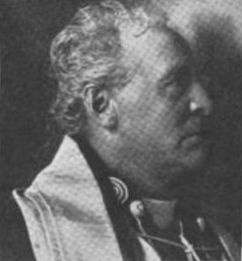 William Richard Harris (1847-1923) was Irish by birth but moved to Canada at an early age, where he became a Catholic priest, eventually becoming Dean of St. Catharines Church in Toronto. His many interests included history and anthropology, which led to a compilation of some of his lectures being published as Prehistoric Man in America [1282]+.
He believed in pre-Columbian contact with America by Europeans, citing the Italian historian Ludovico Antonio Muratori, who showed that Brazil wood was a taxable commodity at the Port of Modena as early as 1306! [p.109]
In the final chapter, he discusses the existence of Atlantis, quoting both classical and modern authors. He concludes with his belief that Atlantis was located in the Atlantic with the Canaries, Azores and Cape Verde as its remnants.
[1282]+ https://archive.org/details/prehistoricmanin00harruoft/mode/2up?view=theater&q=muratori *
Geodesy
Geodesy is usually defined as the measurement and mapping of the Earth. James R. Smith, the author of Introduction to Geodesy [1947] has conflated several definitions to produce “Geodesy, from the Greek, literally means dividing the earth, and as a first objective, the practice of geodesy should provide an accurate framework for the control of national topographical surveys. Thus, geodesy is the science that determines the figure of the Earth and the interrelation of selected points on its surface by either direct or indirect techniques. These characteristics further make it a branch of applied mathematics, one that must include observations that can be used to determine the size and shape of the earth and the definition of coordinate systems for three dimensional positioning; the variation of phenomena near to, or on the surface, such as gravity, tides, earth rotation, crustal movement, and deflection of the plumb line; together with units of measurement and methods of representing the curved earth surface on a flat sheet of paper.”
Geodesy as a science can be traced back to Pythagoras (6th cent. BC), who was thought to be the first to propose the sphericity of the Earth. Aristotle & Archimedes were apparently the first to offer a figure for the diameter of the Earth, suggesting 400,000 and 300,000 stades, respectively. The difference might be partly explained by the use of a different length of stade.
Later, Eratosthenes (276 BC– 195 BC) offered another early attempt to determine the dimensions of our Earth and succeeded with remarkable accuracy.
A controversial aspect of modern geodesy is the claim that many ancient sites were deliberately established at locations that had a specific geodetic relationship to each other and/or the dimensions of the Earth. For example(a) in ancient Egypt, the distance from Giza to the Equator was calculated to be 1/12th the circumference of the Earth, Amarna to the Equator is 1/13th, Luxor 1/14th and Philae 1/15th!
Graham Hancock in his Heaven’s Mirror[855] pointed to similar relationships around the globe, suggesting a possible world grid. This idea of a world grid has a number of supporters, but is often classified as a ‘fringe’ interest, due to the attempt by some to link gridlines with UFOs and their use of the grid as a power source(w). Hancock’s various claims regarding the dimensions of the pyramids and their association with a suggested world grid has been challenged in great detail by a Hall of Maat article by Thomas W. Schroeder(ah). He concluded that “Graham Hancock’s assertion that the Great Pyramid’s dimensions reveal knowledge of earth’s dimensions certainly lacks proof but also fails to hold up to any scrutiny as a viable theory. Each step argued by Hancock; that the Great Pyramid was built to a specific scalar, that the value of the scalar can be definitively demonstrated, that the scalar indicates precession, that the only way ancient Egyptians could estimate precession is to leverage or borrow knowledge from earlier advanced and unrecognized civilizations, are each filled with flaws when taken individually, let alone when strung together to complete his narrative.”
The idea of a global grid has been pursued by a number of investigators, often with conflicting results. In the 1980s, William Becker and Bethe Hagens, published their widely referenced Planetary Earth Grid(aj). They “discussed the code of the Platonic Solids’ positions on Earth, ascribing this discovery to the work of Ivan P. Sanderson, who was the first to make a case for the structure of the icosahedron at work in the Earth. He did this by locating what he referred to as Vile Vortices refer to a claim that there are twelve geometrically distributed geographic areas that are alleged to have the same mysterious qualities popularly associated with the Bermuda Triangle, the Devil’s Sea near Japan, and the South Atlantic Anomaly.”(ak)
Possible related features may be the ley lines identified by Alfred Watkins in Britain(c)(g), the Alesia alignments in France discovered by Xavier Guichard(b) and/or the Heilige Linien of Germany, claimed by Wilhelm Teudt(aa) and supported by Henrich Himmler.
Xavier Guichard (1870-1947) is described as a Paris police chief and philologist. Between 1911 and 1936, he carried out an extensive study of French place-names and found that there were at least 400 sites with names derived from Alesia. When mapped, these hundreds of sites all lay on lines radiating from today’s town of Alaise, reminiscent of Alfred Watkins leylines! Francis Hitching, in The World Atlas of Mysteries [307.78] tells of how Guichard self-published his book, only to have his home bombed during the war in 1945, killing him and destroying most copies of his book. Elsewhere(b) the year of his death is given as 1947! Hitching included two maps reconstructing Guichard’s work.
Ashley Cowie has published a paper(ac) related to Alesia and the work of Guichard and others, as well as his own investigations.
Heinz Kaminski claimed to have discovered a megalithic grid system that stretched from Stonehenge across Europe with an east-west and north-south orientation and referred to as the Stonehenge/Wormbach System(h).
Even more exotic is the ancient Raetiastone navigation system rediscovered by Gerhard Pirchl (1942-2013) and outlined in a book by [1831] Thomas Walli(ae).
I should point out that Marcel Mestdagh also identified a form of a road system, laid out in giant ovals with radials in France. At the centre of these ovals was the ancient city of Sens. Philip Coppens informs us [1275.184] that a further strange discovery by Mestdagh, was that this ancient road network, centred on Sens, was mirrored by a similar network of roads in England, centred on Nottingham!
‘The Way of Virachoca’ in the Andes, which runs through Tiwanaku and is oriented exactly 45° west of true north and runs for over 1000 miles, it has been studied by Maria Scholten d’Ebneth [1236] in the 1970s and expanded on by a number of Spanish speaking commentators and is now the subject of an article by Dave Truman(x).
In 1973, three Russians, engineers Valery Makarov and Vyacheslav Morozov, along with Nikolay Goncharov, an artist, published an article in Russian with the eye-catching title of, Is the Earth a Giant Crystal? (y) This was probably the earliest presentation of an earth grid based on ancient historical sites. A brief history of the Earth grid theories that emerged around this time is available online(z). There is now a Russian geodesy website with an English translation(ab).
David Hatcher Childress published his Anti-Gravity and the World Grid [1303] in 1993, with the modest claim that he “proves that the earth is surrounded by an intricate electronic grid network offering free energy.” Obviously, Childress’ understanding of ‘proof’ is different to mine, as the only proof required is the production of some of this free energy, which he has not done.
Tom Brooks(ai) entered the fray with a study of 1500 prehistoric sites and his conclusion that the inhabitants of ancient Britain had designed a navigation system based on a grid of isosceles triangles(i). Brooks has gone a step further and speculatively claimed that the accuracy of this geometry-based system could only have been designed through “extraterrestrial intervention”(r). This concept is explored more fully in his latest book, Seeing Around Corners: Geometry in Stone Age Britain [863] and in a series of video clips(s). A more critical view of Brooks’ ideas is also available on the Internet(j).
Some years ago, a former employee of a NASA sub-contractor, Maurice Chatelain, claimed that within a 450-mile radius of the Aegean island of Delos, 13 mystical sites, when connected by straight lines formed a perfect Maltese Cross(u)!
Others such as Livio Stecchini(d) and Jim Alison(e) using geodetic calculations, have identified São Tomé and Cape Verde, respectively as the location of Atlantis. I must also include Hugo Kennes, a Belgian researcher with a passionate interest in global grids and sacred geometry(l). Kennes has also informed me of a new Facebook group(q) which deals with all aspects of the subject, as well as another(v) that includes submerged cities and other features.
Anyone interested in pursuing a study of this subject might like to look over James Q. Jacobs’ archaeogeodesy website(f) as well as the BioGeometry website (m).
If you have pursued all the links so far, you can pamper yourself further with a paper(k) by William Becker and Beth Hagens(n). Another researcher in this field is Dan Shaw, whose website(o) gives a good overview of the subject.
Jean-Pierre Lacroix added his weight to the debate with his 1998 paper entitled, The Mapmakers from the Ice Age(t).
A global network of sacred sites was also put forward by Rand Flem-Ath & Colin Wilson in, The Atlantis Blueprint [063]. This book was intended as a sequel to, When the Sky Fell [062], but it generally wandered off into other areas after the first couple of chapters.
I am somewhat sceptical about certain aspects of geodesy, particularly some of the claims of a world grid. However, it does raise many questions that require further study and explanation. In this connection, I would recommend John Sase’s, Curious Alignments [1589] as a good starting point. He confirms the work of Guichard and also offers a range of his own discoveries in the Great Lakes region.
In February 2020, Frank Maglione Nicholson, Ken Phungrasamee & David Grimason, collectively known as The Nazca Group(ad), published, The Nazca Great Circle Map Hypothesis. Their claim is that “The lines and geoglyphs carved into the Nazca plateau represent a map of the Earth. The map is a Great Circle Map: a gnomonic projection, with the center of the Earth as its cartographic viewpoint. Each line on the Nazca Plateau represents a great circle of navigation centred at the centre of the Earth and encircling the entire planet. The majority of the lines on the Nazca Plateau radiate from five loci of origin called radial centres.” I found this rather esoteric proposition difficult to absorb.
Arturo Villamarin has published many books [1864] and papers(af)(ag) in which the geometry and astronomy of archaeological monuments; Göbekli Tepe, Stonehenge, Teotihuacán and Mohenjo Daro, among others, are discussed.
(a) http://www.ancient-wisdom.com/geodesy.htm
(b) http://www.ancient-wisdom.com/xavierguichard.htm
(c) http://www.ancient-wisdom.com/leylines.htm
(d) http://www.metrum.org/mapping/atlantis.htm (link broken Dec. 2020)
(e) http://home.hiwaay.net/~jalison/concl.html
(f) https://web.archive.org/web/20200917015056/http://www.jqjacobs.net/index.html
(g) https://liminalthresholds.blogspot.ie/2008/04/earth-energy-ley-lines.html
(i) See: https://web.archive.org/web/20160628154229/https://www.prehistoric-geometry.co.uk/
(j) https://www.badscience.net/2010/01/voices-of-the-ancients/
(k) https://www.bibliotecapleyades.net/ciencia/antigravityworldgrid/ciencia_antigravityworldgrid02.htm
(m) https://web.archive.org/web/20170328094319/https://www.biogeometry.org/page34.html
(n) Bethe Hagens – Geometry, Anthropology anf the Arts of Consciousness (archive.org)
(o) https://www.vortexmaps.com/grid-history.php
(q) https://www.facebook.com/groups/175027289350368/
(r) https://www.prehistoric-geometry.co.uk/ [See (i)]
(s) https://www.youtube.com/watch?v=R35A80kV0AU&feature=relmfu
(t) https://ancientcartography.net/geoAN.html
(u) https://www.mail-archive.com/ctrl@listserv.aol.com/msg28306.html
(v) https://www.facebook.com/groups/493298404177687/
(x) https://grahamhancock.com/trumand1/
(y) http://web.archive.org/web/20220819135530/https://atlantipedia.ie/samples/archive-3193/
(z) https://www.vortexmaps.com/grid-history.php
(aa) https://www.cantab.net/users/michael.behrend/repubs/teudt_hl/pages/index.html
(ac) Solstice Axis Of The Ancient Gauls — ASHLEY COWIE (archive.org)
(ad) The Nazca Solution – The final solution to what the Nazca Lines represent (archive.org)
(ae) https://www.megalithic.co.uk/article.php?sid=2146413597
(ag) (99+) (PDF) THE GEOMETRY AND ASTRONOMY OF GOBEKLI TEPE | Arturo Villamarin – Academia.edu
(ai) https://www.megalithic.co.uk/article.php?sid=2146413745
(aj) Microsoft Word – antigravity.doc (montalk.net)
(ak) https://www.crystalinks.com/grids.html
Alison, Jim
Jim Alison has written an extensive paper(a) on the highly controversial subject of a global aligment of ancient sites such as the Great Pyramid, Easter Island and Machu Picchu(b). At the end of the first page he concludes that the Cape Verde islands are possibly the remnants of Plato’s Atlantis, based on the geodetic fact that “Machu Picchu and the Great Pyramid are equally distant from the Cape Verde Islands. Easter Island and the Indus Valley are also equally distant from Cape Verde.” For similar reasons he thinks that the Bay of Bengal, as well as near Ilha Martin Vaz, a location off the coast of Brazil, should also be considered as possible candidates.

Macaronesia
Macaronesia is the term used to collectively describe some of the island groups in the Atlantic Ocean. Included are the Canary, Azores, Madeira & Cape Verde archipelagos, of which some, or all, are considered remnants of Atlantis.
Also see Fortunate Isles
Hesperides
The Hesperides in Greek mythology were the daughters of Atlas. They lived on an island in the far west guarding a tree that bore golden apples, made famous in the story of the twelve labours of Hercules who was charged with obtaining some of the apples.
The Hesperides have also been referred to as the Fortunate Islands and is the name applied by classical writers to islands off the west coast of Africa that have been variously identified with the Azores, Canaries or Cape Verde islands. Other opinions place the garden at Gades or on the Atlantic coast of Morocco, such as Pliny’s suggested location of Lixus(b).
According to Wikipedia “the Sicilian Greek poet Stesichorus, in his poem the “Song of Geryon”, and the Greek geographer Strabo, in his book Geographika (volume III), the garden of the Hesperides is located in Tartessos, a location placed in the south of the Iberian peninsula.”(c)
Gonzalo Fernández de Oviedo y Valdés writing in the 16th century [1117] considered the Antilles in the Caribbean to have been the legendary Isles of Hesperides.
While the majority opinion is that the name specifically refers to the Canaries, a minority view espoused by Andrew Collins[072](a) is similar to that of Oviedo, namely that Hesperides refers to the Caribbean, where he is convinced that Cuba had been the home of Atlantis.
Reginald Fessenden argued that the Hesperides lay in the east not the west in chapter one of his The Deluged Civilization of the Caucasus[1012].
(a) https://www.grahamhancock.com/phorum/read.php?f=1&i=122922&t=122922
(b) Pliny the Elder. Historia Naturalis – Book V.
Wirth, Hermann
Hermann Wirth (1885-1981) was a Dutch historian who became one of the co-founders of Himmler’s Ahnenerbe-SS. He was obsessed with Atlantis  and sought to prove that it had existed in the North Atlantic where he believed that it had stretched from Iceland to the Azores. He thought that the only parts of Atlantis to remain above water after its submergence were Cape Verde and the Canary Islands. Wirth named this North Atlantic Atlantis, Thule after the ancient writer Pytheas. He also concluded that a pure monotheistic religion had originated in a common homeland, possibly Plato’s Atlantis(a).
The Nazis who came to believe that the Aryan race had originated on Thule adopted the idea. Wirth also translated the controversial Oera Linda Book, using it to support the party line on Germanic origins(b).
Dacqué, Edgar
 Edgar Dacqué (1878-1945) was a leading German Professor of Palaeontology. We are told by a Dutch website(b) that he thought Atlantis to have been situated on a submarine ridge stretching from Cape Verde to the Caribbean. This sounds like a revised version of the Atlantic landbridges concept that was popular with some scientists at the end of the 19th and beginning of the 20th centuries.
It is reported that he supported (1927) the idea of Cape Verde as the site of Atlantis, but I have been unable to confirm this. His adherence to Theosophy coloured his professional writings, for example with his claim that homo sapiens existed at the time of the dinosaurs. Similar ideas are promoted today by other Theosophists, such as John S. Gordon, who has written two Atlantis related books.
It has been claimed(a) that Dacqué wrote to Hitler in the 1920’s regarding some of his (Dacqué’s) occult ideas.
(a) http://web.archive.org/web/20191017003008/https://atlantipedia.ie/samples/archive-2795/
(b) http://web.archive.org/web/20190703174759/http://atlantipedia.ie/samples/archive-2796/
Montaigne, Michel de
Michel de Montaigne (1533-1592) was an influential leader of the French Renaissance. He had studied law but abandoned it to devote himself to writing, producing three volume s of essays(a) on a wide range of subjects. For over four centuries, Montaigne has influenced Western philosophy and literature. Ignatius Donnelly ascribed the essays of Montaigne as well as the plays of both William Shakespeare and Christopher Marlowe to Francis Bacon[0023]!
In one of his essays, On Cannibals[1019], Montaigne referred to Plato’s Atlantis and apparently accepted its reality. However, he did not express any opinion on the date of the lost civilisation or its location, apart from ruling out America, except to interpret Plato as saying that Atlantis was “situate directly at the mouth of the Straits of Gibraltar”. Modern commentators such as J. Warren Wells have also pointed out that in describing the location of Atlantis, Plato used the Greek word ‘pro’ means before and “that this in turn implies closeness.”[783.79] This conflicts with the idea that Atlantis was situated on or near the Azores, Canaries or Cape Verde archipelagos or further afield in the Americas or Antarctica.
Another small point is that Montaigne refers to ‘Africa and Asia combined’ (Timaeus 24e) rather than ‘Libya and Asia’ confirming that scholars in the 16th century understood that ‘Libya’ in Plato’s time had a broader meaning than just the territory west of Egypt.
Germain, Louis
Louis Germain (1878-1942) was a French zoologist who was among a number of commentators during the early part of the 20th century that identified Atlantis as a continent in the Atlantic, connected to the Iberian peninsula and what was later known as Mauritania in North-West Africa together with the Azores, Canaries and the Cape Verde archipelagos[0886]. He based his views on a study of molluscs on those islands, as well as his suggested ancient links with the European and African mainlands. Improved geological and bathymetric studies gradually led to the abandonment of these ideas. Pierre Termier, a geologist, quoted Germain’s work to reinforce his own view that Atlantis had been located in the Atlantic.