Latest News

Joining The Dots
I have now published my new book, Joining The Dots, which offers a fresh look at the Atlantis mystery. I have addressed the critical questions of when, where and who, using Plato’s own words, tempered with some critical thinking and a modicum of common sense.Read More »
Tiwanaku
Davidovits, Joseph

Joseph Davidovits (1935- ) is a French scientist who has worked on geopolymers since the 1970s. which can be used to create cement that is economically and ecologically superior to Portland cement.
In the late 1970s, Professor Davidovits shook the world of Egyptology with his claim that some of the blocks used to build the Great Pyramid had been cast rather than carved(a)(e)! This generated a debate that has rumbled on over the past four decades(c). Professor Michel Barsoum supports Davidovits(g), Professor Linn Hobbs of MIT is ambivalent(h), while geologist Dipayan Jana is strongly opposed(i).
Ioannis Liritzis is an archaeologist at the University of the Aegean, who, along with his team, challenged Joseph Davidovits’ theory in 2008. Liritzis pointed out that the material used to build Egypt’s most famous monuments “contain hundreds of thousands of marine fossils” that are distributed throughout the blocks in a manner compatible with natural rock(l).
In 2020, Davidovits published a rebuttal of arguments put forward by Jena and others, ensuring the continuance of the controversy for some time to come(k).
Not content with upsetting Egyptologists Davidovits has now annoyed archaeologists at other sites with his more recent claims that casting and not carving had also been used at Tiwanaku and Puma Punku, in Bolivia(b) as well as on Easter Island(d)! This proposed connection between the Easter Island moai and South America, is explained in an interesting video from Davidovits(j).
I have always been cautiously sympathetic towards Davidovits’ geopolymer theories. However, when I read of his claim that the Easter Island statues were also made with artificial stone, my doubts grew. I consulted my well-thumbed paperback copy of Thor Heyerdahl‘s Aku-Aku [1938] and found images between pages 112 and 113 showing unfinished giant moai in a quarry, still with the back part of the statues to be cut free from the rock. The stone tools used for the sculpting of the giants still lay nearby. I am now waiting for Davidovits to comment on Stonehenge!
Furthermore, the claim of casting rather than carving implies the use of moulds, something that I have never seen represented on the walls of any of the tombs or temples of Egypt, nor have the physical remains of any such moulds been found. Compounding this is the fact that sites identified by Davidovits as having used artificial stone, particularly Egypt and Easter Island, suffered from a dearth of suitable timber for making moulds!
Davidovits has also published a short series of eBooks concerning the Bible and Egypt(f). Additionally, there are many other papers by Davidovits on the Researchgate website(m). relating to various aspects of his work.
In 2024, a proposal comparable with Davidovits’ theory was made by Marcell Fóti in The Natron Theory [2108], in which he claims that the “ancient technique of casting artificial stone has been rediscovered and is even being used again in various parts of the world today(n)“. Fóti was also chosen as Author of the Month for February 2025 on Graham Hancock‘s website(o).
A claim related to those of Davidovits and Fóti was put forward in a 2012 article on the Ancient Origins website by Lia Mangolini(p) offered her view that crude chemistry, using plant extracts, provided the means of dissolving rock, which could explain how some quality artefacts as well as tight-fitting ancient masonry, such as found in Peru and Egypt, may have been achieved. This is certainly worth a read, but I would prefer to see a demonstration. She expanded on the use of this acid, known in the Middle East as ‘shamir’, in a separate paper(q).
(a) https://www.geopolymer.org/archaeology/pyramids/are-pyramids-made-out-of-concrete-1/
(b) https://www.geopolymer.org/archaeology/tiahuanaco-monuments-tiwanaku-pumapunku-bolivia/
(c) https://www.geopolymer.org/archaeology/pyramids/deep-misleading-publications-by-geologists/
(d) https://www.geopolymer.org/library/video/they-came-from-america-to-build-easter-island/
(e) https://www.geopolymer.org/shop/product/why-the-pharaohs-built-the-pyramids-with-fake-stones/
(f) https://www.geopolymer.org/shop/cat/archaeology/
(g) https://www.livescience.com/1554-surprising-truth-great-pyramids-built.html
(h) https://news.mit.edu/2008/gathering-concrete-evidence
(j) https://www.geopolymer.org/library/video/they-came-from-america-to-build-easter-island/
(k) http://web.archive.org/web/20250614172307/https://atlantipedia.ie/samples/archive-7474/
(l) Pyramids packed with fossil shells › News in Science (ABC Science) (archive.org)
Lake Titicaca
Lake Titicaca is the largest lake in South America and at over three kilometres is arguably the highest navigable lake in the world**, shared by Peru and Bolivia. In spite of claims to the 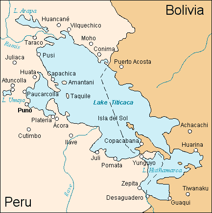 contrary, it is a freshwater lake, but is slowly reducing in size due to the reduced inflow from the retreating Andean glaciers. Lake Poopó to the south has now dried out completely(a).
Karakul in Tajikistan exists at 4,000 metres and “is so salty, it’s almost impossible to navigate a boat on it without capsizing due to the vessel riding so far out of the water.”(e)
To the south of Lake Titicaca are the remarkable archaeological remains of Tiwanaku and the equally exciting Puma Punku. Both sites have produced some extreme theories regarding the builders of these monuments, their technology level and the date of their construction. Arthur Posnansky, followed by Kurt Bilau have proposed a date of circa 9500 BC as the date of the fall of Tiwanaku. There are also reports of pre-Incan structures submerged in Titicaca(d) .
South of Lake Titicaca, near Lake Poopó is Pampa Aullagus, a site identified by Jim Allen as the location of Plato’s Atlantis. While there is little doubt that advanced cultures existed around Titicaca, linking the region to Plato’s story is stretching credibility to its limits. I have already argued in respect of Jim Allen’s Andean theory, that the idea of an invasion of the eastern Mediterranean by an army from the west side of South America is untenable. That they would try it in reed boats like those of Titicaca is equally daft. Then, that this mighty army from ten regions of South America was defeated by the small city-state of Athens is just as laughable.
Equally questionable is the idea that there was a Sumerian presence around Titicaca, in relation to which Clyde Winters quotes(b) James Bailey as well as Ruth and A. Hyatt Verrill in supporting the idea that Lake Manu in Sumerian tradition was in fact Titicaca. The controversial(c) Fuente Magna bowl is also offered as evidence of this idea.
(c) https://www.jasoncolavito.com/blog/the-fuente-magna-bowl-still-fake
(e) (BBC Feb 08, 2019) https://www.bbc.com/travel/story/20190207-asias-dead-lake-where-boats-cant-float
Pumapunku
 Pumapunku is a terraced earthen mound, faced with blocks and an important part of the Tiwanaku archaeological site on the Bolivian Altiplano. It has unique architectural features, including the use of building blocks with up to 80 faces on them. The Tiwanaku site is pre-Inca and has given its earliest radiocarbon date as 536-600 AD and was in use until circa 1000 AD(a), which is a far cry from the flawed 12,000-15,000 BC date claimed by Posnansky(e)(f). Details of how these late dates were arrived at are available in a paper by Jason Yaeger and Alexei Vranich on the Academia.edu website(j).
As with so many other enigmatic ancient sites, various members of the ‘lunatic fringe’ have attributed the construction at this location to either ancient astronauts or Atlanteans or an exotic combination of both, based on either over-fertilised imaginations or flawed data or again, both. Jason Colavito has written a critique of some of the more silly suggestions(b). In September 2024, Ancient Aliens revisited Puma Punku (S20.E20), recycling silly claims about extraterrestrial visitors. Once again, Colavito was obliged to put fingers to keyboard to review this latest episode(l).
Ancient astronaut advocate Von Däniken[1147.221] and Brien Foerster(d) among others, have claimed that the stones of Pumapunku were composed of diorite, an exceptionally hard stone, which would have required a modern diamond-tipped drill to work it. The implication is that only Atlanteans with their advanced technology or extraterrestrials could have worked the stone with such precision.
Brien Foerster also published a paper on the Academia.edu website in Feb. 2023 in which he decries “The extraction, wanton destruction, and recycling of much of the Puma Punku site that can be easily seen in the small nearby town also called Tiwanaku, where many of the buildings, including the church, contain the telltale grey andesite blocks, with smooth flat surfaces, which clearly came from Puma Punku.” He also points out that while Tiwanaku has been declared a World Heritage Site by UNESCO, Puma Punku has received little attention(k).”
However, Colavito and Michael Heiser(c) have pointed out that this identification is untrue and that they were composed of the softer andesite and red sandstone. Apart from this, the Code of Hammurabi was incised on diorite, without Atlantean or extraterrestrial assistance, 2,000 years before the development of Pumapunku!
Joseph Davidovits, who controversially proposed that Giza’s Great Pyramid stones had been cast rather than carved, has also claimed that other well-known structures had been created in a similar manner, such as at Tiwanaku and Puma Punku in Peru(g) and Easter Island(h).
Javier Escalante Moscoso is an architect with a degree in archaeology who has extensively excavated and surveyed the Tiwanaku monuments. (see map above).
A fully illustrated guide to the monuments of Tiwanaku/Puma Punku is an excellent introduction to the site, including a map by Moscoso(i).
(a) https://skeptoid.com/episodes/4202
(b) https://www.jasoncolavito.com/blog/review-of-in-search-of-aliens-s01e07-the-mystery-of-puma-punku
(c) See: https://atlantipedia.ie/samples/archive-2803/
(d) https://hiddenincatours.com/posts/videos/#!/keyword_filter=Puma%20Punku (now password protected)
(e) The age of Tiwanaku (Tiahuanaco) Site, Bolivia (archive.org)
(f) https://www.mail-archive.com/ctrl@listserv.aol.com/msg62910.html
(g) https://www.geopolymer.org/archaeology/tiahuanaco-monuments-tiwanaku-pumapunku-bolivia/
(h) https://www.geopolymer.org/library/video/they-came-from-america-to-build-easter-island/
(i) Tiwanaku, the mysterious pre-Inca capital – mapaymochila.es
(k) (99+) The Enduring Enigma Of Puma Punku in Bolivia | Brien Foerster – Academia.edu
(l) https://www.jasoncolavito.com/blog/review-of-ancient-aliens-s20e20-resurrecting-puma-punku
Pringle, Heather
Heather Pringle “is a Canadian science writer who specializes in  archaeology.” She has written many articles as well as a number of books and has her own website(a). Among her work is the prize-winning The Master Plan[0032], in which she charts the work of the Nazi Ahnenerbe, founded by Himmler, “whose mission was to search for the lost civilization of an ancient master race.” Included in this fascinating book is an interesting account of the Hermann Wirth’s obsession with Atlantis in the North Atlantic, as well as Edmund Kiss’ work at Tiwanaku in Bolivia.
A recent paper(b) by Pringle and Krista Langlois offers evidence that the Bering Strait during the last Ice Age was in fact a vast area of land the size of Australia and that it provided a crossing point for humans and animals earlier and for longer than previously believed.
Pringle has also turned her attention to the Vikings in an interesting National Geographic article(c).
(a) https://heatherpringle.com/
(b) https://www.hakaimagazine.com/article-long/sunken-bridge-size-continent
(c) National Geographic, March 2017 p.34
Fasold, David
 David Franklin Fasold (1939-1998) was an American marine salvage expert, who is best known for his book The Discovery of Noah’s Ark[1054], in which he claimed to have identified the landing site of the Ark. However, his location was not on Mount Ararat but Mount Masher Dagi, some seventeen miles away. A critical review of his research is available online(a). This was not the only controversy with which he was associated. He was also involved in claiming that the Mount Sinai of biblical fame was not in the Sinai peninsula but further east across the Gulf of Aqaba in Saudi Arabia. The story is told in The Gold of Exodus by Howard Blum[1434].
Fasold refers briefly to Atlantis in his ‘Ark’ book (p.298), where he cites a Portuguese tradition that “Atlantida existed west of their shores.” He also mentions a southern Spanish belief that identified the Canaries as ‘Atalya’, which coincidentally is the preferred Atlantis location of Charles Berlitz, who wrote the Introduction to Fasold’s book. He also devotes some pages to discussing the possibility that Tiwanaku was a pre-Flood city (p.299).
Bambrough, Sean
Sean Bambrough is a New Zealand researcher of ancient mysteries. Since 1999, he has been developing a theory that places Plato’s Atlantis in the Andes and identifies its city as Tiwanaku. He has published 37 pages of notes in support of this contention(a)(c). A reader will find them tough going and at times repetitious, but it is clear that he has put a lot of study into the subject, even if he has, in my opinion, produced a very flawed theory.
Several researchers have assumed that when Plato referred to an ‘opposite continent’, he was referring to the Americas: however, Herodotus, who flourished after Solon and before Plato, was quite clear that there were only three continents known to the Greeks: Europe, Asia and Libya [4.42].
Bambrough’s first major error is to equate the sinking of Atlantis with the uplifting of the Andes! The Andes are rising at a rate of some millimetres per year. and the geological evidence is that in the past the uplift rate was somewhat more rapid, which “in geologic terms, rapid means rising one kilometer or more over several millions of years.”(b)(e)
There is no evidence that the cataclysmic upheaval described by him could have occurred around 1400BC. He does not explain how these newly elevated mountains created muddy shoals that made the Atlantic impassable.
As I have already argued with respect to Jim Allen’s Andean theory, the idea of an invasion of the eastern Mediterranean by an army from the west side of South America is untenable. That they would try it in reed boats like those of Titicaca is equally daft. Then, this mighty army from ten regions of South America was defeated by the small city-state of Athens is equally laughable.
I could go on, but just a final couple of points; Plato never described Atlantis as a continent and Kircher’s speculative map depicts Atlantis quite clearly in our Atlantic Ocean between Spain and America.
Bambrough has recently updated his website(d), however, his writing style is as irritating as ever, in particular his excessive use of retronyms (forward slashes).
In 2017, he published(f) an extended ‘checklist’ which he feels supports his location theory. This offering is far too long and repetitious. It is clearly a triumph of quantity over quality
In 2021, Bambrough has now published his paper/ebook on the academia.edu website(g). This migration has done nothing to improve the quality of its content. It is just a huge collection of lists, most of which could be discarded.
(a) https://atlantisonline.smfforfree2.com/index.php/topic,33901.0.html
(b) Taking the pulse of mountain formation in the Andes — ScienceDaily (archive.org)
(c) http://atlantisonline.smfforfree2.com/index.php/topic,33831.15.html
(d) https://atlantipedia.ie/samples/archive-2674/
(e) Taking the pulse of mountain formation in the Andes (phys.org)
(f) Atlantis May have been in Bolivia – History Forum ~ All Empires (archive.org)
(h) All-Dread: Sodom found in Mesopotamian records? (iwillnotbeassimilated.blogspot.com)
Morrison, Tony
Tony Morrison is probably best known for his definitive work on the Nazca Lines, Pathways to the Gods[1036]. Tony and Marion Morrison have developed the South American Pictures.com website in order to show their extensive life’swork. Unfortunately, the southamericanpictures website went offline, but now, many of the image collections have been reassembled and are again available online(b).
In 1998, Morrison published a number of papers, provocatively entitled The Bolivian Atlantis(b-e). They cover familiar territory – Tiwanaku, Pumapunku, Posnansky, Bellamy, Fawcett, Sykes, Blashford-Snell. This was the same year that Jim Allen published his Atlantis: The Andes Solution[877]. Had Allen not done so, I suspect that Morrison might have produced a more detailed book himself, as apparently he and a colleague, Mark Howell, had built up quite a dossier on the subject.
Surprisingly, Morrison did not mention the mysterious puquios of the Nazca region(f), which, with the aid of satellite imagery(g), have been shown to have been part of a sophisticated hydraulic system that supplied water to an extremely arid locality.
(a) https://nonesuchexpeditions.com/south-american-pictures/sap-archaeology-history-index.htm
(b) https://www.nonesuchexpeditions.com/South-American-Pictures/sap-archaeology-history-index.htm
(f) https://www.flickriver.com/photos/tags/puquios/interesting/
(g) (BBC April 8, 2016) https://www.bbc.com/future/story/20160408-the-ancient-peruvian-mystery-solved-from-space
Díaz Romero, Belisario
 Belisario Díaz Romero (1870-1940) was a Bolivian businessman and polymath from La Paz. He had some ideas regarding race and evolution(a). that today would be considered odd, if not offensive. He believed that Tiwanaku had been built by a race of people he calls Homo atlanticus, who had come to America from Atlantis, situated in the Atlantic, over a landbridge from the east, over two hundred million years ago! (a)
His 1906 book Tiahuanacu is now freely available online(b).
His ideas regarding Tiwanaku have been linked(a) with those of Edmund Kiss and Arthur Posnansky.
(a) https://theappendix.net/issues/2013/4/andean-atlantis-race-science-and-the-nazi-occult-in-bolivia
(b) https://archive.org/details/tiahuanacuestud00romegoog (Spanish)
Pauwels, Louis & Bergier, Jacques
Louis Pauwels (1920-1997) & Jacques Bergier (1912-1978) were the authors of the bestselling The Morning of the Magicians[910] and its sequel Impossibilities Possibilities[911]. Pauwels was the founder of the Planéte magazine and Bergier was a nuclear physicist. It is reported that Nostra magazine (20-26, April 1977) carried an article by Bergier (real name, Mik Ezdanitoff) where he discusses the possibility of a Hollow Earth(a), as has Andrew Gough more recently(d).
Atlantisforschung has reprinted an excerpt from their book “Aufbruch ins dritte Jahrtausend – Von der Zukunft der phantastischen Vernunft” (p.356-364) which deals with the idea of a Hollow Earth and its investigation by elements within National Socialism in Germany(b).
Their books rush from subject to subject like a train going from station to station without stopping long enough to pick up passengers. Uncharacteristically, they devoted quite a number of pages to Hörbiger’s strange lunar theories, particularly the notion that the Earth has had a number of moons, each of which eventually fell to Earth. Fortunately, the current No.4 Moon appears fairly stable(c).
This in turn led to Tiwanaku which the authors refer to as ‘Atlantis of the Andes’, as having great antiquity, but suggest there was a second Atlantis in the Atlantic that was destroyed later by “waters from the north”, which inspired the story of the Flood of Noah in the Bible.
(a) http://artivision.fr/BergieretlaTerrecreuse.html#
(c) Jacques Bergier – Atlantisforschung.de (atlantisforschung-de.translate.goog)
(d) Are We Living Inside the Earth? | Andrew Gough

Pauwels

Bergier
Geodesy
Geodesy is usually defined as the measurement and mapping of the Earth. James R. Smith, the author of Introduction to Geodesy [1947] has conflated several definitions to produce “Geodesy, from the Greek, literally means dividing the earth, and as a first objective, the practice of geodesy should provide an accurate framework for the control of national topographical surveys. Thus, geodesy is the science that determines the figure of the Earth and the interrelation of selected points on its surface by either direct or indirect techniques. These characteristics further make it a branch of applied mathematics, one that must include observations that can be used to determine the size and shape of the earth and the definition of coordinate systems for three dimensional positioning; the variation of phenomena near to, or on the surface, such as gravity, tides, earth rotation, crustal movement, and deflection of the plumb line; together with units of measurement and methods of representing the curved earth surface on a flat sheet of paper.”
Geodesy as a science can be traced back to Pythagoras (6th cent. BC), who was thought to be the first to propose the sphericity of the Earth. Aristotle & Archimedes were apparently the first to offer a figure for the diameter of the Earth, suggesting 400,000 and 300,000 stades, respectively. The difference might be partly explained by the use of a different length of stade.
Later, Eratosthenes (276 BC– 195 BC) offered another early attempt to determine the dimensions of our Earth and succeeded with remarkable accuracy.
A controversial aspect of modern geodesy is the claim that many ancient sites were deliberately established at locations that had a specific geodetic relationship to each other and/or the dimensions of the Earth. For example(a) in ancient Egypt, the distance from Giza to the Equator was calculated to be 1/12th the circumference of the Earth, Amarna to the Equator is 1/13th, Luxor 1/14th and Philae 1/15th!
Graham Hancock in his Heaven’s Mirror[855] pointed to similar relationships around the globe, suggesting a possible world grid. This idea of a world grid has a number of supporters, but is often classified as a ‘fringe’ interest, due to the attempt by some to link gridlines with UFOs and their use of the grid as a power source(w). Hancock’s various claims regarding the dimensions of the pyramids and their association with a suggested world grid has been challenged in great detail by a Hall of Maat article by Thomas W. Schroeder(ah). He concluded that “Graham Hancock’s assertion that the Great Pyramid’s dimensions reveal knowledge of earth’s dimensions certainly lacks proof but also fails to hold up to any scrutiny as a viable theory. Each step argued by Hancock; that the Great Pyramid was built to a specific scalar, that the value of the scalar can be definitively demonstrated, that the scalar indicates precession, that the only way ancient Egyptians could estimate precession is to leverage or borrow knowledge from earlier advanced and unrecognized civilizations, are each filled with flaws when taken individually, let alone when strung together to complete his narrative.”
The idea of a global grid has been pursued by a number of investigators, often with conflicting results. In the 1980s, William Becker and Bethe Hagens, published their widely referenced Planetary Earth Grid(aj). They “discussed the code of the Platonic Solids’ positions on Earth, ascribing this discovery to the work of Ivan P. Sanderson, who was the first to make a case for the structure of the icosahedron at work in the Earth. He did this by locating what he referred to as Vile Vortices refer to a claim that there are twelve geometrically distributed geographic areas that are alleged to have the same mysterious qualities popularly associated with the Bermuda Triangle, the Devil’s Sea near Japan, and the South Atlantic Anomaly.”(ak)
Possible related features may be the ley lines identified by Alfred Watkins in Britain(c)(g), the Alesia alignments in France discovered by Xavier Guichard(b) and/or the Heilige Linien of Germany, claimed by Wilhelm Teudt(aa) and supported by Henrich Himmler.
Xavier Guichard (1870-1947) is described as a Paris police chief and philologist. Between 1911 and 1936, he carried out an extensive study of French place-names and found that there were at least 400 sites with names derived from Alesia. When mapped, these hundreds of sites all lay on lines radiating from today’s town of Alaise, reminiscent of Alfred Watkins leylines! Francis Hitching, in The World Atlas of Mysteries [307.78] tells of how Guichard self-published his book, only to have his home bombed during the war in 1945, killing him and destroying most copies of his book. Elsewhere(b) the year of his death is given as 1947! Hitching included two maps reconstructing Guichard’s work.
Ashley Cowie has published a paper(ac) related to Alesia and the work of Guichard and others, as well as his own investigations.
Heinz Kaminski claimed to have discovered a megalithic grid system that stretched from Stonehenge across Europe with an east-west and north-south orientation and referred to as the Stonehenge/Wormbach System(h).
Even more exotic is the ancient Raetiastone navigation system rediscovered by Gerhard Pirchl (1942-2013) and outlined in a book by [1831] Thomas Walli(ae).
I should point out that Marcel Mestdagh also identified a form of a road system, laid out in giant ovals with radials in France. At the centre of these ovals was the ancient city of Sens. Philip Coppens informs us [1275.184] that a further strange discovery by Mestdagh, was that this ancient road network, centred on Sens, was mirrored by a similar network of roads in England, centred on Nottingham!
‘The Way of Virachoca’ in the Andes, which runs through Tiwanaku and is oriented exactly 45° west of true north and runs for over 1000 miles, it has been studied by Maria Scholten d’Ebneth [1236] in the 1970s and expanded on by a number of Spanish speaking commentators and is now the subject of an article by Dave Truman(x).
In 1973, three Russians, engineers Valery Makarov and Vyacheslav Morozov, along with Nikolay Goncharov, an artist, published an article in Russian with the eye-catching title of, Is the Earth a Giant Crystal? (y) This was probably the earliest presentation of an earth grid based on ancient historical sites. A brief history of the Earth grid theories that emerged around this time is available online(z). There is now a Russian geodesy website with an English translation(ab).
David Hatcher Childress published his Anti-Gravity and the World Grid [1303] in 1993, with the modest claim that he “proves that the earth is surrounded by an intricate electronic grid network offering free energy.” Obviously, Childress’ understanding of ‘proof’ is different to mine, as the only proof required is the production of some of this free energy, which he has not done.
Tom Brooks(ai) entered the fray with a study of 1500 prehistoric sites and his conclusion that the inhabitants of ancient Britain had designed a navigation system based on a grid of isosceles triangles(i). Brooks has gone a step further and speculatively claimed that the accuracy of this geometry-based system could only have been designed through “extraterrestrial intervention”(r). This concept is explored more fully in his latest book, Seeing Around Corners: Geometry in Stone Age Britain [863] and in a series of video clips(s). A more critical view of Brooks’ ideas is also available on the Internet(j).
Some years ago, a former employee of a NASA sub-contractor, Maurice Chatelain, claimed that within a 450-mile radius of the Aegean island of Delos, 13 mystical sites, when connected by straight lines formed a perfect Maltese Cross(u)!
Others such as Livio Stecchini(d) and Jim Alison(e) using geodetic calculations, have identified São Tomé and Cape Verde, respectively as the location of Atlantis. I must also include Hugo Kennes, a Belgian researcher with a passionate interest in global grids and sacred geometry(l). Kennes has also informed me of a new Facebook group(q) which deals with all aspects of the subject, as well as another(v) that includes submerged cities and other features.
Anyone interested in pursuing a study of this subject might like to look over James Q. Jacobs’ archaeogeodesy website(f) as well as the BioGeometry website (m).
If you have pursued all the links so far, you can pamper yourself further with a paper(k) by William Becker and Beth Hagens(n). Another researcher in this field is Dan Shaw, whose website(o) gives a good overview of the subject.
Jean-Pierre Lacroix added his weight to the debate with his 1998 paper entitled, The Mapmakers from the Ice Age(t).
A global network of sacred sites was also put forward by Rand Flem-Ath & Colin Wilson in, The Atlantis Blueprint [063]. This book was intended as a sequel to, When the Sky Fell [062], but it generally wandered off into other areas after the first couple of chapters.
I am somewhat sceptical about certain aspects of geodesy, particularly some of the claims of a world grid. However, it does raise many questions that require further study and explanation. In this connection, I would recommend John Sase’s, Curious Alignments [1589] as a good starting point. He confirms the work of Guichard and also offers a range of his own discoveries in the Great Lakes region.
In February 2020, Frank Maglione Nicholson, Ken Phungrasamee & David Grimason, collectively known as The Nazca Group(ad), published, The Nazca Great Circle Map Hypothesis. Their claim is that “The lines and geoglyphs carved into the Nazca plateau represent a map of the Earth. The map is a Great Circle Map: a gnomonic projection, with the center of the Earth as its cartographic viewpoint. Each line on the Nazca Plateau represents a great circle of navigation centred at the centre of the Earth and encircling the entire planet. The majority of the lines on the Nazca Plateau radiate from five loci of origin called radial centres.” I found this rather esoteric proposition difficult to absorb.
Arturo Villamarin has published many books [1864] and papers(af)(ag) in which the geometry and astronomy of archaeological monuments; Göbekli Tepe, Stonehenge, Teotihuacán and Mohenjo Daro, among others, are discussed.
(a) http://www.ancient-wisdom.com/geodesy.htm
(b) http://www.ancient-wisdom.com/xavierguichard.htm
(c) http://www.ancient-wisdom.com/leylines.htm
(d) http://www.metrum.org/mapping/atlantis.htm (link broken Dec. 2020)
(e) http://home.hiwaay.net/~jalison/concl.html
(f) https://web.archive.org/web/20200917015056/http://www.jqjacobs.net/index.html
(g) https://liminalthresholds.blogspot.ie/2008/04/earth-energy-ley-lines.html
(i) See: https://web.archive.org/web/20160628154229/https://www.prehistoric-geometry.co.uk/
(j) https://www.badscience.net/2010/01/voices-of-the-ancients/
(k) https://www.bibliotecapleyades.net/ciencia/antigravityworldgrid/ciencia_antigravityworldgrid02.htm
(m) https://web.archive.org/web/20170328094319/https://www.biogeometry.org/page34.html
(n) Bethe Hagens – Geometry, Anthropology anf the Arts of Consciousness (archive.org)
(o) https://www.vortexmaps.com/grid-history.php
(q) https://www.facebook.com/groups/175027289350368/
(r) https://www.prehistoric-geometry.co.uk/ [See (i)]
(s) https://www.youtube.com/watch?v=R35A80kV0AU&feature=relmfu
(t) https://ancientcartography.net/geoAN.html
(u) https://www.mail-archive.com/ctrl@listserv.aol.com/msg28306.html
(v) https://www.facebook.com/groups/493298404177687/
(x) https://grahamhancock.com/trumand1/
(y) http://web.archive.org/web/20220819135530/https://atlantipedia.ie/samples/archive-3193/
(z) https://www.vortexmaps.com/grid-history.php
(aa) https://www.cantab.net/users/michael.behrend/repubs/teudt_hl/pages/index.html
(ac) Solstice Axis Of The Ancient Gauls — ASHLEY COWIE (archive.org)
(ad) The Nazca Solution – The final solution to what the Nazca Lines represent (archive.org)
(ae) https://www.megalithic.co.uk/article.php?sid=2146413597
(ag) (99+) (PDF) THE GEOMETRY AND ASTRONOMY OF GOBEKLI TEPE | Arturo Villamarin – Academia.edu
(ai) https://www.megalithic.co.uk/article.php?sid=2146413745
(aj) Microsoft Word – antigravity.doc (montalk.net)
(ak) https://www.crystalinks.com/grids.html