Latest News

Joining The Dots
I have now published my new book, Joining The Dots, which offers a fresh look at the Atlantis mystery. I have addressed the critical questions of when, where and who, using Plato’s own words, tempered with some critical thinking and a modicum of common sense.Read More »
Werner E. Friedrich
Crimea
Crimea is a large peninsula on the Black Sea coast of Ukraine. At the time of writing (April 2023) Crimea was still occupied by the Russian military. From an atlantological point of view, it is interesting that one of the principal icons of Ukraine is a stylised trident, the symbol of Poseidon.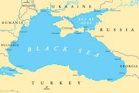
Crimea itself has had a number of attempts made to associate it with the location of Atlantis. The most eye-catching promoters of this idea were the late Leon Flying Eagle and Mary Whispering Wind, who published their theory in The Atlantis Motherland [0138] nearly twenty years ago. They claimed(a) that in the Crimean port city of Kerch the nearby Mithridat Hill was the original site of the capital city of Atlantis, confirmed by the surrounding topography that matched closely Plato’s description. They have also suggested that the shallow Strait of Kerch between Crimea and Russia as the location of Plato’s ‘shoals‘(c).
An interesting detail is that the Strait of Kerch was one of several locations that the ancient Greeks referred to as the Pillars of Heracles, listed by Robert Schoch in Voices of the Rocks [454.87], but, unfortunately, without citing his source.
They further claim(b) that there is evidence that the Kopet-Dagh fault line, which runs just above the strait, experienced a devastating (8.9) earthquake around 9600 BC, destroying Atlantis in the Strait. At this time, what we now call the Sea of Azov, was the well-irrigated plain adjacent to the city of Atlantis described by Plato. They claim that the earthquake caused a massive influx of water from the Caspian Sea, which had been rising due to the melting ice caps in the north. This combination caused the creation of the Sea of Azov and the flooding of Atlantis.
All this would have been fine except that at the start of their homepage, they announced that “Thirty-nine thousand years ago a primitive tribe of wild robust Neanderthals celebrated the beginning of a new species. Visitors from a distant planet united with their tribe. Together they created the great Empire of Atlantis, the Motherland of all Modern Humans.” For me, this just undermines the credibility, if not the rationality of the authors.
Anatoliy Ivanovich Zolotukhin is a Ukrainian researcher from the city of Nykolaiv (also known as Mykolaiv) who authored Homer: The Immanent Biography [1015], in which he claims that Homer was born in Alibant (Mykolaiv) on September 14, 657 BC(f). He follows the views of Karl Ernst von Baer (1792-1876) who believed that most of Odysseus’s travels took place in the Black Sea, rather than the Mediterranean. Additionally, Zolotukhin locates Atlantis in the western Crimean area of Evpatoria(d) on his multilingual website, with the inviting title of Homer and Atlantis(e).
Werner E. Friedrich is a German researcher who published a bilingual booklet in 2006 [0695] in which he firmly located Atlantis in the Black Sea region, circa 10,000 BC, on a plain west and east around today’s Crimean peninsula.
Christian & Siegfried Schoppe are a father and son team of German researchers, who firmly assert that Atlantis was located in the Black Sea. More specifically they suggest that Snake Island(h) situated 35km east of the Danube Delta, was the location of the Atlantean capital. Snake Island has also been referred to on a Russian website(i) that discusses a Black Sea Atlantis. It includes some video clips with Russian dialogue. Snake Island has also been adopted by George K. Weller as the location of Atlantis(j). Snake Island also featured in the current Russian invasion of Ukraine.
In his 2020 book, Apocalypse [1874], Dr Sean Welsh agreed that Noah’s Ark finally rested on Mt. Ararat, but took everyone by surprise by claiming that it was not Ararat in Turkey but Ararat mountain/hill on Crimea’s Kerch Peninsula!
Very ancient pyramids have also been claimed for Crimea(g).
(a) http://www.atlantis-motherland.com/home.html
(b) Great Atlantis Flood (archive.org)
(c) Index (atlantis-today.com)
(d) https://homerandatlantis.com/?lang=en
(e) https://homerandatlantis.com/??-??????/?lang=en
(f) Nikolaev Pushkin club (archive.org)
(g) http://web.archive.org/web/20220702054604/https://atlantipedia.ie/samples/archive-3619/
(h) https://en.wikipedia.org/wiki/Snake_Island_(Ukraine)
(i) http://survincity.com/2010/04/conspiracy-theory-black-sea-atlantis-the-case-of/ (link broken Dec.2020)
Bosporus, The
?The Bosporus or Bosphorus is described by Wikipedia as “a narrow, natural strait and an internationally significant waterway located in northwestern Turkey. It forms part of the continental boundary between Asia and Europe, and divides  Turkey by separating Anatolia from Thrace. It is the world’s narrowest strait used for international navigation. The Bosporus connects the Black Sea with the Sea of Marmara, and, by extension via the Dardanelles, the Aegean and Mediterranean seas, and by the Kerch Strait, the Sea of Azov.”
A number of modern commentators have promoted the Bosporus as the location of the Pillars of Herakles; Eberhard Zangger, Christian and Siegfried Schoppe and Werner E. Friedrich.
Arysio dos Santos in his book Atlantis [320.186] noted that “The Bosphorus was considered to be the site of the ‘Pillars of Hercules’ even before the name of these famous features was transplanted to the region of Gibraltar, where it remains stuck down to the present time. In reality, bosporus or bosphorus (or bosporos or bosphoros, rather, the Greek words from which the Latin name derives) means ‘cattle passage, oxford’ precisely because Hercules was said to have crossed there with the cattle he rustled from Geryon, in Erytheia.”
Strait of Gibraltar
The Strait of Gibraltar according to Greek mythology was created by Herakles. Neville Chipulina explains that “it seems that the person responsible for the myths about Hercules was Peisander of Rhodes, a 7th century BC Greek epic poet who apparently got the story from an unknown Pisinus of Lindus who almost certainly plagiarised it from somebody else. In other words, it’s a pretty old story.”(c)
The Strait is very much a part of many current Atlantis theories. Primarily, it is contended that the region itself held the location of Atlantis. This is based on Plato’s statement that Eumelos, also known as Gadeirus, the twin brother of Atlas the first king of Atlantis gave his name to Gades, known today as Cadiz. Andalusia in Southern Spain has been the focus of attention for over a hundred years. In recent years Georgeos Diaz-Montexano and his rival Jacques Colina- Girard have been investigating the waters of the Strait itself while south of the Strait Jonas Bergman has advanced his theory that Atlantis was located just across the Strait in Morocco.
Although there is general acceptance that the Pillars of Heracles had their final resting place in the vicinity of the Strait of Gibraltar, it must be noted that there have been other candidates at different times with equally valid claims. The location of the ‘Pillars’ referred to by Plato at the time of Atlantis is the subject of continuing debate.
Archaeologist Josho Brouwers has noted that(g) “according to Strabo (3.5.5), Hercules raised the Pillars during one of his Twelve Labours to mark the western edge of the inhabited world. One pillar was identified as the Rock of Gibraltar (called Mount Calpe in ancient times), with the other was Ceuta (Mount Abile) on the African side of the narrow strait.
Diodorus Siculus mentions that Hercules put the Pillars in place as a monument to himself (4.18.4). He also adds that Hercules either narrowed the passage in order to prevent sea-monsters from the Atlantic to enter the Mediterranean, or to actually open the mountain so that the Atlantic could mingle with the Mediterranean. On this issue, as Diodorus puts it, “it will be possible for every man to think as he may please” (4.18.5).” For me it raises a warning flag regarding the hasty acceptance of ancient myths and traditions as having an historical basis.
Strato, the philosopher, quoted by Strabo, spoke of a dam separating the Atlantic and the Mediterranean being breached by a cataclysm. This idea was reinforced by comments of Seneca. Furthermore, a number of Arabic writers, including Al-Mas’udi, Al-Biruni and Al-Idrisi, have all concurred with this idea of a Gibraltar land bridge in late prehistory.
A more radical theory is that of Paulino Zamarro who contends that the Strait was in fact closed by a landbridge during the last Ice Age because of the lower sea levels together with silting. When the waters rose and breached the landbridge, he believes that the flood submerged Atlantis, which he situates in the Aegean. Others support Zamarro’s idea of a Gibraltar Dam amongst whom are Constantin Benetatos and Joseph S. Ellul.
Terry Westerman on his heavily illustrated website surveys impact craters globally. He suggests that “The Strait of Gibraltar was formed by two meteor impacts. The first blasted the round area in the western Mediterranean Sea to form a land bridge between Spain and Morocco.” He maintains that a second impact broke the landbridge around 5.33 million years ago, creating what is called the Zanclean Flood which refilled the then desiccated Mediterranean(d).
A German-language website(a) presented some of the following data+, apparently recording the dramatic widening of the Strait of Gibraltar between 400 BC and 400 AD. The same list was included in the ‘Strait of Gibraltar’ entry of the German Wikipedia(b) until a few years ago. It has since been removed.
Alexander Braghine offered [156.139] similar data*, which, unfortunately, is also unreferenced.
+Damastes of Sigeum, circa 400 BC. – about 1.3 km
+Pseudo-Skylax, probably fourth Century BC – about 1.3 km
*Turiano Greslio? 300BC – 8.0 km
*+Titus Livius (Livy) 59 BC- 17 AD – 10.5 km
+Strabo 63 BC- 24 AD – from 9.5 to 13.0 km
+Pomponius Mela , 50 AD – about the 15.0 km
+Pliny the Elder, 50 AD – about 15.0 km
*+Victor Vicensa (*Vitensa?), 400 AD – about 18 km
Procopius, 550 AD – about 15.0 km
The above figures suggest that in the latter half of the first millennium BC, the Strait of Gibraltar was gradually widened. However, the figures given suggest that between 400 and 550 AD the Straits narrowed again seems absurd. Nevertheless, until the methods used and all the data on offer have been verified, the idea must be treated with great caution.
My list had originally included Euctemon, the 5th century BC Athenian astronomer, however, Werner E. Friedrich notes that Euctemon was referring to the Sea of Marmara near the entrance to the Black Sea [0695.38].
However, more recently, John Jensen Jnr. has offered a comparable, if shorter, number of dates showing the reducing width of the strait the further back you go, from which he extrapolated that around 3450 YBP when he believes that a landbridge there was breached(e).
Jensen’s estimated widths for the strait are without references, but suggest a similar story of a gradually widening entrance to the Mediterranean.
1,100 BC 2 Miles (3.2 km}
480 BC 4 Miles (6.5 km
60 BC 7 Miles (11.2 km)
1200 AD 12 Miles (19.3 km)
Now 15 Miles (24 km)
Georgeos Diaz-Montexano has also referred to the descriptions by ancient writers of the Strait of Gibraltar indicating a width of around two kilometres. Unfortunately, he does not cite references(f). He is also sympathetic to the existence of an earlier landbridge at Gibraltar.
(a) https://de.academic.ru/dic.nsf/dewiki/1337738
(b) https://de.wikipedia.org/w/index.php?title=Stra%C3%9Fe_von_Gibraltar&oldid=60093153
(c) https://gibraltar-intro.blogspot.ie/2015/10/bc-pillars-of-hercules-if-ordinary.html
(d) The Formation of the Strait of Gibraltar (archive.org)
(e) https://www.migration-diffusion.info/article.php?id=514 and https://www.linkedin.com/pulse/earths-axis-tilt-john-jensen-jr-
(f) https://web.archive.org/web/20200630064033/http://freerepublic.com/focus/f-news/1011563/posts
(g) The Pillars of Hercules – Ancient World Magazine
Friedrich, Werner E.
Werner E. Friedrich is a German researcher who published a booklet in 2006[695] in which he firmly located Atlantis in the Black Sea region circa 10,000 BC, on a plain west and east around today’s Crimean peninsula. In contrast to Ryan and Pitman, who claim that the Black Sea was inundated from the Aegean, Friedrich proposes that the opposite occurred when a much smaller Black Sea was flooded with water from the melting ice sheets at the end of the last Ice Age. He claims that prior to the creation of the Bosporus that the Sea of Marmara was connected to the Black Sea, through the Sakarya River. He places the Pillars of Heracles on the Princes’ Islands in the Sea of Marmara and supports his thesis with quotations from the Athenian astronomer, Euctemon (fl 430 BC) and the Greek historian, Ephorus (c. 400-330 BC). Friedrich has a bilingual German/English website(a) promoting his theory of Atlantis in the Black Sea, which he will add to from time to time. In order to understand the complexities of Friedrich’s ideas I recommend that interested readers study his booklet and its supportive website.
(a) https://www.wf-web-features.de/index.html (offline Oct.’14)