Latest News

Joining The Dots
I have now published my new book, Joining The Dots, which offers a fresh look at the Atlantis mystery. I have addressed the critical questions of when, where and who, using Plato’s own words, tempered with some critical thinking and a modicum of common sense.Read More »
Bosporus
Bosporus, The
?The Bosporus or Bosphorus is described by Wikipedia as “a narrow, natural strait and an internationally significant waterway located in northwestern Turkey. It forms part of the continental boundary between Asia and Europe, and divides  Turkey by separating Anatolia from Thrace. It is the world’s narrowest strait used for international navigation. The Bosporus connects the Black Sea with the Sea of Marmara, and, by extension via the Dardanelles, the Aegean and Mediterranean seas, and by the Kerch Strait, the Sea of Azov.”
A number of modern commentators have promoted the Bosporus as the location of the Pillars of Herakles; Eberhard Zangger, Christian and Siegfried Schoppe and Werner E. Friedrich.
Arysio dos Santos in his book Atlantis [320.186] noted that “The Bosphorus was considered to be the site of the ‘Pillars of Hercules’ even before the name of these famous features was transplanted to the region of Gibraltar, where it remains stuck down to the present time. In reality, bosporus or bosphorus (or bosporos or bosphoros, rather, the Greek words from which the Latin name derives) means ‘cattle passage, oxford’ precisely because Hercules was said to have crossed there with the cattle he rustled from Geryon, in Erytheia.”
Symplegades
The Symplegades or ‘Clashing Rocks’, situated at the Bosporus, are known in Greek mythology as one of the challenges encountered by Jason and the Argonauts. Pindar describes Jason’s journey to the ‘Inhospitable Sea’ (Black Sea) via the Clashing Rocks [1787.61].
Rosario Vieni has suggested that the Symplegades, were precursors of the Pillars of Heracles, John Lundwall in Mythos and Cosmos [1747.305-6] also suggests a linkage between the Symplegades and the Pillars of Herakles!(a)
>According to Atlantisforschung Christine Pellech suggested that the Symplegades was a reference to the Strait of Magellan at the southern tip of South America(b)!<
(a) https://www.quora.com/Where-are-the-pillars-of-Hercules (just over halfway down the page)
(b) Symplegaden – Atlantisforschung.de (atlantisforschung-de.translate.goog) *
Pillars of Herakles
Pillars of Heracles, when Googled, will offer nearly 100,000 results, with Wikipedia and Britannica usually heading the list.
Wikipedia says, “The Pillars of Hercules was the phrase that was applied in Antiquity to the promontories that flank the entrance to the Strait of Gibraltar. The northern Pillar, Calpe Mons, is the Rock of Gibraltar. A corresponding North African peak not being predominant, the identity of the southern Pillar, Abila Mons, has been disputed throughout history, with the two most likely candidates being Monte Hacho in Ceuta and Jebel Musa in Morocco.”
Britannica says, “Pillars of Heracles, also called Pillars of Hercules, two promontories at the eastern end of the Strait of Gibraltar. The northern pillar is the Rock of Gibraltar at Gibraltar, and the southern pillar has been identified as one of two peaks: Jebel Moussa (Musa), in Morocco, or Mount Hacho (held by Spain), near the city of Ceuta (the Spanish exclave on the Moroccan coast).”
Although these two popular sources substantially agree with each other, the concurrence is misleading. In fact, various aspects of the Pillars have been the subject of controversy for a very, very long time.
CONFUSION
The Pillars of Heracles (PoH) according to conventional wisdom, were always situated somewhere in the vicinity of the Strait of Gibraltar. However, the truth is rather different. The question of the location of the Pillars has led to confusion and controversy for millennia. A flavour of this was contained in William Smith’s still highly-regarded Dictionary of Greek and Roman Geography [1719] of 1854, which lists many of the locations proposed by ancient authors. One short paragraph in it encapsulates the confusion that has existed in the past and still does, although seldom highlighted, today, “But when the ancient writers began to investigate the matter more closely, they were greatly divided in opinion as to where the Pillars were to be sought, what they were, and why they were called by the name of Hercules.”(w)
When I began my study of the Pillars, it became obvious very early on that the subject was more complicated than usually presented. Frankly, I never expected to end up as bewildered as I did. First of all, I find that some of the ancient writers have not only referred to two pillars but even three(x) and four of them.
HERAKLES
That was bad enough, but when I was then confronted with a multiplicity of mythical heroes named Herakles, numbering three (Diodorus), four (Servius), six Cicero, even (Herodotus)(ap(z), and a prize-winning forty-four by Varro, I was even more perplexed.
Ariadna Arriaza published a paper about the multiplicity of Herakles in ancient texts, particularly Herodotus(z), who offered at least seven! William Smith’s Dictionary noted that “Herodotus tells us that the original Heracles hailed from Egypt and says that according to the Egyptian tradition, Heracles was one of twelve deities descended from the original eight gods who created the universe (2.43-5). Diodorus claimed that when Osiris went to accomplish his labors he left the government of Egypt in the hands of this primordial Heracles. Remarkably, Pausanias, Tacitus, and Macrobius all confirm that Heracles hailed from Egypt [1729.401]“.
John K. Lundwall noted the profusion of Herakles [1747] and also refers to the Phoenician Herakles – Melqart and its possible influence on the development of the Greek myth. He concluded that ” Heracles was not invented by the Greeks. He was inherited by the Greeks. Half of his labors descend from Mycenaean or Minoan times, implicating a Heracles-like figure with a series of labors in the days before Greece was founded. Gilgamesh is a Near Eastern Heracles.”
Apart from the Canaanite Melqart(ak) and the biblical Samson, Herakles was also associated with Briareus or Cronos. Aelian, in his Varia Historia 5.3, noted that “Aristotle affirms that those Pillars which are now called of Hercules, were first called the Pillars of Briareus.”
Herodotus visited the temple of Heracles in Tyre with two pillars, one of gold and the other emerald. According to the priests there, it had stood for two thousand three hundred years or from approximately 2700 BC. Another suggestion has been that the ‘Pillars Heracles’ was a Greek rendering of the Egyptian ‘Pillars of Osiris’.(t)
So not only do we have a number of Heracles but also a variety of names for them.
THE NATURE OF THE PILLARS
My confusion was further compounded by the term stelai used by Plato to describe the Pillars, which is the Greek word for stone or wooden slabs used as boundary or commemorative markers, not a reference to supportive columns. I must emphasise that Plato referred to stelai, not mountains.
Rhys Carpenter favoured the idea that the term, when applied to the Strait of Gibraltar, was used with the sense of boundary markers, indicating ”the limits of the Inner Sea that, for the Greeks, was the navigable world” [221.156]. It is reasonable to suggest that as the Greeks became more expansionist with their trade and colonisation, new limits were set as they moved incrementally westward along with the appellation of the ‘Pillars of Hercules’.
One advocate of this idea, Thorwald C. Franke, maintains that the westward shift of the ‘Pillars’ from the Strait of Messina towards Gibraltar occurred a century before Solon. He expanded on this at the 2008 Atlantis Conference [0750.170] and in his 2006 book on Herodotus [0300].
Eberhard Zangger noted[483.109]that in a 1927 article, Richard Hennig “investigated the root of the term ‘the Pillars of Heracles’ and concluded that it was not initially applied to the Straits of Gibraltar but to another locality at the end of the Greek sphere of influence.”
Further difficulties were provided by early authors describing the Pillars as mountains, statues, islands or promontories! Egerton Sykes was convinced that the Pillars had been two menhirs, 30ft tall, that had stood on top of the Rock of Gibraltar(u)! In this regard, it is interesting that Jürgen Spanuth dismissed those who have identified the red and white cliffs of Heligoland as the Pillars of Heracles, decrying the idea as a fallacy [015.100]. He explained that “Natural rock formations were not what was originally meant by the Pillars of Heracles. Those at the Straits of Gibraltar were not, as one so often reads, the rocks to the north and south of the Straits, but two man-made pillars which stood before the temple of Heracles at Gades (present-day Cádiz) about 100 km north of the Straits.” Spanuth also denied that the Straits of Gibraltar were ever closed [p248].
Some of the earliest references to the Pillars of Heracles come from Pindar, who seems to have used the term as a metaphor for the limits of human capabilities, be it in sport or more usually, geographical boundaries. So as the Greeks gradually extended the range of their maritime expansion, new boundaries were established and designated as the new Pillars of Heracles. If there had been a Metaxa Book of Records at that time it would have frequently updated the location of the ‘Pillars’.
Totally unrelated to Atlantis is the natural formation on Antigua known as the so-called Pillars of Hercules(bd).
PHOENICIAN PILLARS
Gades was originally named Gadir (walled city) and is thought to have been founded by the Phoenicians around 1100 BC and taken over by Carthage circa 814 BC, although there are question marks around both dates.(ao)
Strabo wrote; “Concerning the foundation of Gades, the Gaditanians report that a certain oracle commanded the Tyrians to found a colony by the Pillars of Hercules. Those who were sent out for the purpose of exploring, when they had arrived at the strait by Calpe, imagined that the capes which form the strait were the boundaries of the habitable earth, as well as of the expedition of Hercules, and consequently, they were what the oracle termed the Pillars. They landed on the inside of the straits, at a place where the city of the Exitani now stands. Here they offered sacrifices, which however not being favourable, they returned. After a time others were sent, who advanced about 1500 stadia beyond the strait, to an island consecrated to Hercules, and lying opposite to Onoba, a city of Iberia: considering that here were the Pillars, they sacrificed to the god, but the sacrifices being again unfavourable, they returned home. In the third voyage, they reached Gades and founded the temple in the eastern part of the island, and the city in the west. (3.5.5.) If this story has any historical basis, the first Phoenician visits to the vicinity of Gibraltar must have taken place before 1100 BC.
Heracles is the Greek counterpart of the Phoenician god Melqart, who was the principal god of the Phoenician city of Tyre. Melqart was brought to the most successful Tyrian colony, Carthage and subsequently further west, where at least three temples dedicated to Melqart have been identified in ancient Spain, Gades, Ebusus, and Carthago Nova. Across the Strait in Morocco, the ancient Phoenician city of Lixus also had a temple dedicated to Melqart.
Pairs of free-standing columns were important in Phoenician temples and are also to be found in Egyptian temples, as well as being part of Solomon’s temple (built by Phoenician craftsmen). Consequently, the pillars of Melqart temple in Gades are considered by some to be the origin of the reference to the Pillars of Melqart and later of Heracles (by the Greeks) and Hercules (by the Romans) as applied to the Strait of Gibraltar.
Greek colonisation by individual city-states got underway early in the first millennium BC. This expansion of trade and territory took place gradually during the eighth, seventh and sixth centuries BC. The online Ancient History Encyclopedia website noted that “One of the most important consequences of this process, in broad terms, was that the movement of goods, people, art, and ideas in this period spread the Greek way of life far and wide to Spain, France, Italy, the Adriatic, the Black Sea, and North Africa. In total then, the Greeks established some 500 colonies which involved up to 60,000 Greek citizen colonists, so that by 500 BCE these new territories would eventually account for 40% of all Greeks in the Hellenic World.”(aq)
While the AHE offers an excellent overview of Greek colonisation, a valuable and more detailed study is also available online(ar), namely, The Expansion of the Greek World, Eighth to Sixth Centuries B.C. [1752], edited by Boardman & Hammond.
LOCATION, ACCORDING TO CLASSICAL AUTHORS
Classical writers frequently refer to the ‘Pillars’ without being in any way specific regarding their location. It always seemed to me that when the Greeks began their Mediterranean trade expansion and colonisation outside the Aegean, apart from the Pentapolis of Cyrenaica in the far south and some possible trading posts in the Levant, they did so exploiting the northern shores of the Mediterranean. Understandably, they would have taken the shortest route from the Greek mainland to the heel of Italy and later on to Sicily. As this development progressed, new limits were set and in time, exceeded. I suggest that these limits were each in turn designated the ‘Pillars of Heracles’ as they expanded further. I speculate that Capo Colonna (Cape of the Column) in Calabria(as), in South Italy, may have been one of those early boundaries. Interestingly, 18th-century maps display up to five islands near the cape, which are no longer shown on charts(at). This appeared on respected atlases as late as 1860. According to Armin Wolf, these were originally added to maps by Ortelius, inspired by some earlier cartographers and the comments of Pseudo-Skylax and Pliny(au)!
Homer did not use the term Pillars of Heracles, although he does refer to the Pillars of Atlas (Odysseus 1.51-4).
Hecataeus (550-476 BC), according to Oliver D. Smith in a 2019 paper(y), placed the PoH at Mastia, which is thought to be Cartagena in southeastern Spain. This identification is principally based on the early 20th-century studies of Adolf Schulten.
Scylax of Caryanda (late 6th & early 5th cent. BC) describes in his Periplus(a), a guide to the Mediterranean, that the Maltese Islands lay to the east of the Pillars of Heracles. This would place the archipelago east of the Gulf of Gabes, which is compatible with the opinions of Hofmann and Sarantitis. Anton Mifsud argues that had the Pillars been located at Gibraltar, the islands to the east would have been the Balearics, which was certainly true for the ancient Greek shore-hugging mariners.
Pindar (518-438 BC) would appear to have considered that the phrase ‘Pillars of Herakles’ was a metaphor for the limits of physical prowess as well-established Greek geographical knowledge (Olympian 3.43-45), a boundary that was never static for long. In 1778, Jean-Silvain Bailly was certain that the Pillars of Hercules were just “a name that denotes limits or boundaries.” [0926.2.293] More recently, Professor Dag Øistein Endsjø, from the University of Oslo in Norway, has endorsed the idea that the ancient Greeks used the ‘Pillars of Heracles’ as a metaphor to express the limits of human endeavour(d) and quotes the classicist, James S. Romm in support(e). In a sentence, the Pillars advanced along with extended geographical certainty.
When the Greek expansion westward in the Mediterranean began to gather pace, no location remained long enough as the new limit of Greek influence to enable it to acquire any permanent recognition as the metaphorical Pillars of Herakles. However, when they reached the western end of the Mediterranean and were blocked by the Phoenicians, this region offered the final resting place of the ‘Pillars’, which retains the title today.
Isocrates (436-338 BC) was an ancient Greek rhetorician and a contemporary of Plato. He wrote of Herakles setting up Pillars near Troy as a boundary marker, following the Trojan War (To Philip 5.112)(bi)(bj).
Aristotle (385-322 BC) Aristotle wrote(g) that “outside the pillars of Heracles the sea is shallow owing to the mud, but calm, for it lies in a hollow.” This is not a description of the Atlantic that we know, which is not shallow, calm or lying in a hollow and which he refers to as a ‘sea’ not an ‘ocean’.
Eratosthenes (276-194 BC) was thought by many to have been responsible for the fixing of the PoH at Gibraltar. In fact, in the early days of the compilation of Atlantipedia, I wrote that “no writer prior to Eratosthenes had referred to the Pillars of Heracles being located at Gibraltar.” This was wrong and was the result of a combination of hastily quoting Sergio Frau(al) and badly paraphrasing a passage from George Sarantitis’ book – “How, from the times of Ephorus (405 BC), Plato and Aristotle and until Eratosthenes (276 BC) and Strabo (63 BC), did the Pillars ‘migrate’ to Gibraltar?”(m)
Pseudo-Scymnus (c.140 BC) placed the Pillars at Mainake(y) thought to be modern Malaga. However, Spanuth cites from the same source a reference to a ‘Northern Pillar’ in the land of the Frisians, as support for his North Sea Atlantis!
Also in the Atlantic, there have been some speculative attempts to link the basaltic pillars at the Giant’s Causeway in Northern Ireland and its counterpart across the sea in Scotland’s Isle of Staffa with the PoH.
Strabo (64 BC-23 AD), a Greek historian and geographer, noted that “close to the Pillars there are two isles, one of which they call Hera’s Island; moreover, there are some who call also these isles the Pillars.” (Bk.3, Chap.5) The two isles referred to as near the Pillars have never been identified; as there are no islands in or near the Strait at Gibraltar, but there are in the Sea of Marmara near the Bosporus, another location candidate!
He also records that Alexander the Great built an altar and ‘Pillars of Heracles’ at the eastern limit of his Empire.
Pliny the Elder (23/24-79 AD) noted that in Sogdiana in modern Uzbekistan, there was reputed to be an altar and ‘Pillars of Heracles’.
Reginald Fessenden opted for the Caucasus noting “The fact that Nebuchadnezzar, after reaching them in his northern expedition, next went to the north shore of the Black Sea and to Thrace; and that Hercules, coming back from the pillars with the cattle of Geryon, traversed the north shore of the Black Sea (see Megasthenes, quoted by Strabo and Herodotus, 4.8), puzzled the ancient geographers because they thought that the Pillars were at the straits of Gibraltar. And because they had overlooked the fact that the Phoenicians of Sidon had known that the Pillars had been lost and that the Phoenicians had sent out four expeditions to look for them, but had reached no conclusion from these expeditions except that the straits of Gibraltar were not the true Pillars of Hercules. See Strabo, 2.5.
Of course, the fact that the true Pillars of Hercules were in the north Caucasus isthmus explains why both Nebuchadnezzar and Hercules, after leaving the Pillars, came next to the shores of the Black Sea.” (w)
Tacitus (55-120 AD), the renowned Latin historian, in his Germania (chap.34), clearly states that it was believed that the Pillars of Hercules were located near the Rhine in the territory of the Frisians. So the Romans either thought that the ‘Pillars’ were not situated at Gibraltar or could exist at more than one location at the same time. In Atlantisforschung, the late Bernhard Beier, quoting Günther Nesselrath, suggests that I have overstated the value of the Tacitus reference(bg).
I contend that although there is no doubt that the term ‘Pillars of Herakles’ was eventually applied to the Gibraltar region, it was also applied to a few stops as the Greeks stuttered their way there from the Aegean along the Mediterranean. Ronald H. Fritze, an ardent Atlantis sceptic, noted in his Invented Knowledge [709.23] ” While at various times the geography of the ancient Greeks applied the name of Pillars of Hercules to other locations in the Aegean region, in this case, Plato is quite explicit that he means the Pillars of Hercules that are now known as the Straits of Gibraltar.” So if it can be accepted that the PoH was applied to several locations in the Aegean by the Greeks, why not also to other places as they gradually expanded westward?
MODERN LOCATION THEORIES
From the 19th century onwards, locations for the Pillars were proposed which stretched the length of the Mediterranean and beyond.
Perhaps the first ‘modern’ writer to propose the Eastern Mediterranean as the location for the ‘Pillars’ was a Russian, Avraam Norov (1795-1869). He considered them to have been shrines, drawing on both Greek and Arabic sources that could be investigated further.
Some also believed that other ‘Pillars of Heracles’ existed in the Eastern Mediterranean and the Black Sea region. This is possible because, until the 1st millennium BC, the Greeks were, generally speaking, restricted to those areas. It would appear that for the ancient Greeks, the Pillars of Heracles marked straits or promontories at the limits of their known world. These boundaries were gradually extended further and further as their maritime capabilities improved. and probably led to the decline in the usage of the title at former boundaries, eventually leaving us with only the Strait of Gibraltar to carry the name.
In the Late Bronze Age, the Bosporus in the east and probably the Strait of Sicily in the west confined the Greeks. It was only shortly before Solon’s trip to Egypt that the Greek colony of Massalia (modern Marseilles) was founded and so, at last, the western limit of the Mediterranean was brought within easier regular reach of Greek ships, but Massalia was still nearly 2,000 km by sea from Gades (Cadiz). Later their furthest trading post was probably at Mainake (Malaga), beyond which was Phoenician territory and it was 100 km from Gibraltar and 200km from Cadiz.
The idea that geographical designations can radically change their location over time is illustrated by the name (H)esperia, which means ‘evening land’ or as we might say ‘land of the setting sun’, was originally used by Greeks to indicate Italy and later employed by Roman writers as a reference to Spain. It could be argued that the Greek use of this appellation could be an indication that when introduced, they were not too sure what lay beyond Italy!
Fundamentalist Atlantology, as proclaimed by the ‘prophet’ Ignatius Donnelly in the 19th century, will accept no explanation other than that Plato was referring to ‘Pillars’ near Gibraltar‘. Certainly, it is reasonable to conclude that Plato may have been referring to the Strait of Gibraltar, but it is also evident that this was not the only location with that designation in ancient times. Consequently, if any of the alternatives mentioned above enable the construction of a new credible Atlantis location hypothesis, then it deserves careful rational consideration.
Even today, the debate continues, highlighted by modern classical scholars, such as Duane W. Roller (1946- ) in Through the Pillars of Herakles [1483.203], in which he states that “The exact location of the Pillars of Herakles was long a matter of dispute. Although they may seem obvious today as the two large mountains at the western end of the Mediterranean, Gibraltar and Jebel Mousa, such was not the case in antiquity, and understanding of the region changed as topographical knowledge increased. At some early date, Homer’s mythical and unlocated Pillars of Atlas (Od. 1.51-4) became associated with the wanderer Herakles, but as the western end of the Mediterranean became better understood in the latter seventh century BC, uncertainty increased rather than decreased. Herodotus, who mentioned the Pillars several times, placed them east of Gadeira and Tartessos (4.8, 152), which could mean anywhere in the 50-kilometer-long strait (the modern Strait of Gibraltar) that runs east to the opening of the Mediterranean, through rugged topography with several promontories that could be identified as the Pillars, although especially prominent are Gibraltar and Jebel Mousa (the Kalpe and Abilyx of Strabo) at the eastern end. The early prominence of Gadeira caused some (such as Pindar) to place them in that area, or at points east thereof, such as Tarifa or Cape Trafalgar: the sources seem uncertain as to whether height or prominence was the defining criterion.”
Several alternative locations have been identified as being referred to in ancient times as the Pillars of Heracles. Robert Schoch [0454.87] writes “This distinctive name, taken from the most powerful hero of Greek mythology, was given to a number of ancient sites known in modern times by quite different appellations. The Greeks, however, used the name Pillars of Heracles to mark other sites besides Gibraltar, some outside the Mediterranean – namely, the Canary Islands in the Atlantic and the Strait of Kerch dividing the Black Sea from the Sea of Azov – and even more inside – specifically, the Strait of Bonifacio between Corsica and Sardinia, the Strait of Messina between mainland Italy and Sicily, the Greek Peleponnese, the mountainous coast of Tunisia, and the Nile Delta.” Unfortunately, Schoch offers no references.
Even Nikolai Zhirov, a proponent of an Atlantic Atlantis, accepted that they were other locations considered to have been designated Pillars of Herakles, both within and beyond Gibraltar, as shown on a map of half a century ago in his well-regarded book [458.86]. He lists, Gibraltar, Gulf of Gabes, Kerch Strait, the Moroccan coast, the Nile Delta and the Peleponnese, but like Schoch, fails to provide references.
We also find that Arthur C. Clarke suggested there was evidence the early Greeks did not originally refer to the Strait of Gibraltar as the Pillars of Heracles. Clarke also failed to cite his sources but expressed a personal preference for the Strait of Messina.
WITHIN THE MEDITERRANEAN
I shall begin my review of PoH locations at the eastern end of the Mediterranean in Lebanon.
TYRE
J. P. Rambling has placed the ‘Pillars’ on Insula Herculis, now a small sunken island, immediately south of Phoenician Tyre(k).
BOSPORUS
Eberhard Zangger [0483] cited the work of Servius(aa) in which he wrote (“Columnas Herculis legimus et in Ponto et in Hispania”) translated by Zangger as “through the Columns of Herakles we go within the Black Sea as well as in Spain”. Eberhard Zangger has suggested peninsula of Yenisehir at the Dardanelles, which is only 5Km from Troy, as the possible location of the PoH.
Isocrates, mentioned above, recorded that following the Trojan War, Herakles set up Pillars as boundary markers near Troy – “while they with the combined strength of Hellas found it difficult to take Troy after a siege which lasted ten years, he (Heracles), on the other hand, in less than as many days, and with a small expedition, easily took the city by storm. After this, he put to death to a man all the princes of the tribes who dwelt along the shores of both continents; and these he could never have destroyed had he not first conquered their armies. When he had done these things, he set up the Pillars of Heracles, as they are called, to be a trophy of victory over the barbarians, a monument to his own valor and the perils he had surmounted, and to mark the bounds of the territory of the Hellenes.”(ax).
A German site(ab) by Willy Dorn offers a comparable translation – “Durch die Säulen des Herakles fahren wir im Schwarzen Meer wie auch in Spanien”) “We drive through the pillars of Heracles in the Black Sea as well as in Spain”.
Similarly, a Spanish author, Paulino Zamarro, wrote(ac) – (“pues sabemos de Columnas de Hércules tanto en el Ponto como en Hispania”) which translates as “for we know of Columns of Hercules both in the Ponto and hispania”.
Nicolae Densusianu offered “according to what we read, the Pillars of Hercules exist both in the Pontos region, and also in Hispania.”(ad)
The Stockton University website(ae), similarly offers “We read of pillars of Hercules both in the Black Sea and in Spain”.
Whichever translation is used, it confirms that at least two locations were concurrently referred to as the ‘Pillars of Heracles’.
Werner E. Friedrich has also argued [695] in favour of Pillars at the Bosporus, citing Euctemon of Athens (c.440 BC) who described the Pillars as two islands near the entrance to the strait, having characteristics comparable to Prince’s Islands in the Sea of Marmara. Friedrich quotes Ephorus identifying two islands as the Pillars, just as Strabo did (see above), although there are no islands in the Strait of Gibraltar, apart from the uninhabitable islet of Perejil off the coast of Morocco. Edwin Bjorkman noted [181.62] that “the insignificant little islet of Perijil” was the chosen location of Calypso’s home by Victor Berard.
Christian & Siegfried Schoppe, in support of their Black Sea location for Atlantis, maintain that the Pillars were situated at the Bosporus and not Gibraltar. They contend “the maintained misinterpretation results from the fact that Herakles went to Iberia. At late Hellenistic and at Roman times Iberia was Spain. However, this leads to inconsistencies: After putting up the Pillars (supposed at Gibraltar) Herakles put together a fleet to go to Iberia – he was still there!” This makes no sense. However, as the Schoppes pointed out that in the distant past ‘Iberia’ related to the land of an ethnic group to the east of the Black Sea.
George K. Weller has added his support to the concept of the Pillars being situated at the Bosporus, in his brief paper on Atlantis(ba). On the other side of the Black Sea, the Strait of Kerch, leading to the Sea of Azov, was favoured by Alexandre Moreau de Jonnes as the site of the Pillars(bc).
DANUBE
Moving eastward and inland from the Black Sea, we have a strong case presented for the Danube as the home of its own Pillars. The Danube was known to the ancient Greeks as the Istros as well as Okeanos Potamos. The lower reaches of the river have ancient and deep-rooted cultural links with Hercules that are still very obvious today.
In Romania, just north of Orsova, on a tributary of the Danube, lies Baile Herculane, sometimes called Hercules’ City, which has seen human habitation since the Paleolithic era. There is a legend that a weary Hercules stopped in the valley to bathe and rest. During the Roman occupation, the local Herculaneum Spa was known all over the Empire.
Pindar confirms the visit of Hercules to the Danube (Estrus)(ag).
Even as early as the 1st century BC, local coinage displayed images of Hercules(af).
Just over a century ago, Nicolae Densusianu finished his monumental work, Ancient Dacia(ah), which included fifteen pages(j) of the most comprehensive and fully referenced defence of any PoH location proposed, namely, the Iron Gates gorge on the Danube in ancient Dacia – modern Romania.
Alexandra Furdui is a Romanian architect, who now lives in Australia. In her book entitled Island: Myth…Reality …or Both? [1598], she posits Atlantis as a large island in the antediluvian freshwater Black Sea ruled by the Titans of Greek mythology. Some of whom, later started another civilisation in the lower Danube, where she claims the Pillars of Herakles were situated, probably the result of being influenced by the earlier work of Nicolae Densusianu, which she has translated into English.
Densusianu’s offering has been reinforced recently, by Antonije Shkokljev & Slave Nikolovski–Katin, who have recorded [1742] a version of the ‘Labours of Hercules’ that took place in the land of the Hyperboreans and its Danube River(ai). Other more recent writers have also specified the Iron Gates as the location of the PoH.
A paper presented at the 2008 Atlantis Conference by Ticleanu, Constantin & Nicolescu [0750.375] has the ‘Pillars’ at the Iron Gates, but places Atlantis a little further west, on what is now the Pannonian Plain. In 2020, Veljko Milkovi? proposed the same locations for the ‘Pillars’ and Atlantis(ay).
Similarly, an anonymous commentator, ‘Sherlock’, referencing Pindar (Olympian 3) also places the Pillars at the confluence of the Seva and Danube rivers, near today’s Belgrade(s).
AEGEAN
Back in the Mediterranean, Capes Maleas and Matapan (Tainaron) in the Peloponnese are the two most southerly points of mainland Greece. They have been proposed by Galanopoulos & Bacon [0263] as the Pillars of Heracles, when the early Greeks were initially confined to the Aegean Sea and the two promontories were the western limits of their maritime knowledge at that time. They argue it is possible that the ‘Pillars of Hercules’ are not the Straits of Gibraltar.
“This has been the subject of some interesting conjectures. Nearly all the labours of Hercules were performed in the Peloponnese. The last and hardest of those which Eurytheus imposed on the hero was to descend to Hades and bring back its three-headed dog guardian, Cerberus. According to the most general version Hercules entered Hades through the abyss at Cape Taenarun (the modern Cape Matapan), the western cape of the Gulf of Laconia. The eastern cape of this gulf is Cape Maleas, a dangerous promontory, notorious for its rough seas.
Pausanias records that on either side of this windswept promontory were temples, that on the west dedicated to Poseidon, that on the east to Apollo. It is perhaps therefore not extravagant to suggest that the Pillars of Hercules referred to are the promontories of Taenarum and Maleas; and it is perhaps significant that the twin brother of Atlas was allotted the extremity of Atlantis closest to the Pillars of Hercules. The relevant passage in the Critias (114A-B) states:
‘And the name of his younger twin-brother, who had for his portion the extremity of the island near the pillars of Hercules up to the part of the country now called Gadeira after the name of that region, was Eumelus in Greek, but in the native tongue Gadeirus — which fact may have given its title to the country.’
Since the region had been named after the second son of Poseidon, whose Greek name was Eumelus, its Greek title must likewise have been Eumelus, a name which brings to mind the most westerly of the Cyclades, Melos, which is in fact not far from the notorious Cape Maleas. The name Eumelus was in use in the Cyclades; and the ancient inscription (‘Eumelus an excellent danger’) was found on a rock on the island of Thera.
In general, it can be argued from a number of points in Plato’s narrative that placing ‘the Pillars of Hercules’ at the south of the Peloponnese makes sense, while identifying them with the Straits of Gibraltar does not [p.97].”
James Mavor [265] supported Galanopoulos’ proposed location for the Pillars.
Rodney Castleden [225.6] also defended this view, noting that “before the sixth century BC several mountains on the edges of mainland Greece were seen as supports for the sky. Among others, the two southward-pointing headlands on each side of the Gulf of Laconia were Pillars of Heracles.” Other commentators have seen this identification of the Pillars as ratification of the Minoan Hypothesis(p). Caleb Howells is one of the most recent to endorse the Gulf of Laconia as the site of the Pillars(bm).
Alex Hawk supports the Cyclades as the location of the Pillars(bo).
Paulino Zamarro has mapped 13 locations(f) identified as Pillars by classical authors and expands on this further in his book [0024]. He identified Pori, a rocky islet north of the Greek island of Antikythera, as the location of the Pillars.
Izabol Apulia, better known as ‘Map Mistress’ placed the Pillars on Rhodes(be).
EGYPT
In Volume No. 4 of the 1897 Science Review Journal, Alexander Karnoschitsky placed the Pillars of Heracles near Sais in Egypt and located Atlantis in the eastern Mediterranean(bb).
More recently two writers, R. McQuillen and Hossam Aboulfotouh, have independently suggested the vicinity of Canopus situated in the west of the Nile Delta as the location of the ‘Pillars’. Luana Monte, a supporter of the Minoan Hypothesis, has also proposed [0485] a location at the mouth of the Nile Delta, where the recently rediscovered sunken city of Herakleoin was situated. This identification appears to have been made in order to keep the Minoan Empire west of the ‘Pillars’.
STRAIT of OTRANTO
Moving on, we find that Alessio Toscano has suggested the Pillars were situated at the Strait of Otranto and that Plato’s ‘Atlantic’ was in fact the Adriatic Sea!
The Arcus-Atlantis website had the following titbit to offer(bl) – “From a very early period in their exploration of the seas around their homeland, the ancient Greeks appear to have assigned twin pillars to locations regarding as marking the furthest possible point of exploration. Perhaps the earliest of these, which are described in the De Mirabilibus Auscultatonibus, a work ascribed (wrongly) to Aristotle, were to be found in the northernmost reaches of the Adriatic Sea, either at the mouth of the River Po or just south of Istria.“
The STRAIT of MESSINA is a strong contender as a location of the PoH in the Central Mediterranean. For years I have struggled with the idea that the Atlanteans had attacked from beyond the Pillars located at Gibraltar, since Plato tells us that they already had control of northern Africa and southern Italy, along with several islands. To me, this could only make sense if the Pillars were situated some distance east of Gibraltar.
I recently recalled that Thorwald C. Franke had arrived at the same conclusion in a paper delivered to the 2008 Atlantis Conference held in Athens [750], where he noted that “On the one hand Atlantis is said to have ruled in Italy and Northern Africa before it invaded the region ‘within the straits’. On the other hand, Atlantis wanted to subdue ‘at a blow…..the whole region within the straits.’ How could Atlantis subdue ‘at a blow’ the ‘whole’ region ‘within the straits’ after Atlantis already had conquered the whole western Mediterranean sea”.
“This is easily explained if we localise the Atlantis straits at the straits of Messina and consider the sea ‘within the straits’ to be the eastern Mediterranean sea only.”
I have discovered that in the Strait of Messina there had been a pillar erected north of the ancient city of Rhegium (Reggio Calabria), apparently marking what had been, at that time, the closest point to Sicily. Little is known about the early history of the pillar or even its precise location(av).
Some commentators had suggested the Strait of Sicily, but I find it strange that what we call today the Strait of Sicily is 90 miles wide. Now the definition of ‘strait’ is a narrow passage of water connecting two large bodies of water. How 90 miles can be described as ‘narrow’ eludes me. Is it possible that we are dealing with a case of mistaken identity and that the ‘Strait of Sicily’, when referred to in ancient times, was in fact the Strait of Messina, which is narrow? Keeping in mind that Philo of Alexandria (20 BC-50 AD) in his On the Eternity of the World(aj) wrote “Are you ignorant of the celebrated account which is given of that most sacred Sicilian strait, which in old times joined Sicily to the continent of Italy?” So, understandably, the Strait of Messina is a ‘prime suspect’.
On the other hand, the Strait of Messina was one of the locations known as the site of the ‘Pillars’ and considering that mariners at that time preferred to stay close to the coast, I would opt for the Strait of Messina, rather than the more frequently proposed Strait of Sicily. In a 1959 article(r) entitled Atlantis – A New Theory, Arthur R. Weir investigates the story of Scylla & Charybdis and is happy to accept that it refers to features in the Strait of Messina. In commenting on the Pillars, he notes it is “quite clear that while to a Roman of the time of Julius Caesar the ‘Pillars of Heracles’ meant the Straits of Gibraltar, to a Greek of six centuries or more earlier they meant the Straits of Messina, and this immediately suggests a very different location for Atlantis.” Weir goes on to suggest a location, south of Sardinia and east of the Balearics.?
SICILY
Federico Bardanzellu locates the Pillars on the island of Motya off the west coast of Sicily(h), a view that is hotly disputed. This would suggest that Atlantis was located west of there, which would bring you to Sardinia – 200 miles away. However, the Pillars were described as being close to Atlantis, which makes this suggestion improbable.
Sergio Frau in his book, Le Colonne d’Ercole: Un’inchiesta [0302], insists that the Pillars were in fact located in the Strait of Sicily. He sees this location as agreeing with the writings of Homer and Hesiod. He discusses in detail the reference by Herodotus to an island to the west of the Pillars, suggesting that the word ‘ocean’ had a different meaning than today and pointing out that elsewhere Herodotus refers to Sardinia as the largest island in the world. Following this lead, Frau concluded that Atlantis was located in Sardinia.
Louis Godart, an Italian archaeologist of Belgian extraction, has offered a number of points that support Frau’s location(bh), including one particular comment – “First of all, in the lists in our possession, there is no place name that can refer, with a minimum degree of credibility, to a toponym located west of the Strait of Sicily.” I think that this should be investigated further, as Godart offers no references and the implications, if verified, are far-reaching.
SARDINIA
 Sardinia has considerable support as the location of Atlantis. This idea appears to have had addition support from Professor Giorgio Saba who has identified Carloforte, on the island of San Pietro, off the southwest coast of Sardinia, as the site of the Pillars of Heracles, known locally as the ‘Faraglione Antiche Columns’.
STRAIT of BONIFACIO
The Strait of Bonifacio is the name of the 11km stretch of water that lies between Sardinia and Corsica. As mentioned above, Robert Schoch included this strait in a list of locations which he believes were formerly designated by the Greeks as ‘Pillars of Heracles’, alas, all without references. Paolo Valente Poddighe who nominated Sardinia and Corsica as Atlantis 40 years ago, also situated the ‘Pillars’ at Bonifacio.
MALTA
As Felice Vinci mentioned earlier, according to Aristotle, the Pillars of Heracles were also known by the earlier name of ‘Pillars of Briareus’ (Aelian Var. Hist.5.3). Plutarch places Briareus near Ogygia, from which we can assume that the Pillars of Heracles are close to Ogygia [019.270]. Since Malta is identified by some as Ogygia, it is not unreasonable to conclude that the Pillars were probably in the region of the Maltese Islands.
Anton Mifsud has now revised his opinion regarding the Pillars and in a December 2017 illustrated article(o) he identified the Maltese promontory of Ras ir-Raheb, near Rabat, with its two enormous limestone columns as the Pillars of Herakles. This headland had originally been topped by a Temple of Herakles, confirmed by archaeologist, Professor Nicholas Vella. A 2020 article about the Minoans offered additional support for this location(v).
STRAIT OF SICILY
Robert J. Tuttle is the author of The Fourth Source [1148], in which he touched on the subject of Atlantis and took issue with the translations of Plato’s text by Bury and Lee, who refer to the ‘Atlantic Ocean’, which he claims should read as the ‘Sea of Atlantis’ and locates the ‘Pillars of Herakles’ somewhere between Tunisia, Sicily and the ‘toe of Italy’.
Pier Paolo Saba also placed the PoH between Sicily and Tunisia.
Rosario Vieni has suggested that the Symplegades, at the Bosporus, encountered by Homer’s Argonauts, were precursors of the Pillars of Heracles, although Vieni settled on the Strait of Sicily as their location [1177] before Sergio Frau adopted the same location. However, there is little doubt that during the last two centuries BC, ‘the Pillars’ referred almost exclusively to the Strait of Gibraltar.
Delisle de Sales placed the ‘Pillars’ not too far away at the Gulf of Tunis, the gateway to Carthage.
GULF OF GABES
As mentioned above, Scylax of Caryanda described in his Periplus(a) that the Maltese Islands lay to the east of the Pillars of Heracles, which would place the archipelago east of the Gulf of Gabes. Antonio Usai, in a critique of Frau’s book Usai, opted for the Pillars having been between the east coast of Tunisia and the islands of Kerkennah in the Gulf of Gabes [0980]. George Sarantitis presented a paper to the 2008 Atlantis Conference in which he also argued that the Pillars had been situated in the Gulf of Gabes [750.403]. He cites Strabo among others to highlight the multiplicity of locations that have been attributed to Pillars in ancient times.
Ulrich Hofmann combines the Periplus of Scylax with the writings of Herodotus to build a credible argument for placing Atlantis in North Africa in Lake Tritonis, now occupied by the chotts of modern Algeria and Tunisia. Consequently, Hofmann places the Pillars in the Gulf of Gabés. Hofmann also argues that the Pillars were part of Atlantis rather than separate from it.
 I must not forget Paul Borchardt who advocated Tunisia as the location of Atlantis. In a map drawn by him (see left), he placed the Pillars (Columnae Herculis) at the Gulf of Gabes(bf).
Alan Mattingly strongly supports the Gulf of Gabes as at least one location for the ‘Pillars’. I have taken the liberty of quoting his comments in full from his very interesting Kindle book Plato’s Atlantis and the Sea Peoples: A Review of Context and Evidence [1948].
“Further, Herodotus strongly implies that the Pillars of Herakles that he is talking about are located near to Gabes in the Little Syrtis. ‘I have now mentioned all the pastoral tribes along the Libyan coast. Up country further to the south lies the region where wild beasts are found, and beyond that there is a great belt of sand stretching from Thebes in Egypt to the Pillars of Herakles. (Book IV.181) Thus far I am able to give you the names of the tribes who inhabit the sand belt, but beyond this point my knowledge fails. I can affirm, however; that the belt continues to the Pillars of Herakles’ and beyond…’ (Book IV.185) Since Herodotus’ tribal descriptions do not go west of Carthage these statements suggest that the Pillars of Herakles he is referring to lie somewhere within the Gulf of Sirte. I would note that there is a sand belt that indeed extends from Egypt through Libya to southern Tunisia and Algeria, although not in one unbroken mass. It does not however go further west than the ouadi Rhir, there are separate sand seas to the south-west in Mauretania and Mali, but it should be noted that there is no great sand belt in the vicinity or anywhere near the Straits of Gibraltar. Since Herodotus is professing no knowledge of what lies beyond the Atlantes or beyond Carthage along the North African Coast the implication would be that the Pillars are to the East of these points (along the coast south and east of Carthage). Since the sand belt touches the coast last near Gabes, the further implication is that the Pillars were in this vicinity.”
GIBRALTAR
There is no doubt that the region of Gibraltar was considered, at least by the Greeks, to be home to the Pillars from the middle of the first millennium BC. However, although sought by Phoenicians, Greeks and Romans, they were never found. I am forced to contend that they were principally metaphorical.
Oliver D. Smith investigated the matter of the ‘Pillars’ and concluded that there were four locations in southern Iberia nominated as home to the Pillars and named them as Mastia, Mainake, Strait of Gibraltar and Cádiz(az).
In 1916, Konrad Miller, the German historian who published a number of old maps, offered one that purported to show the ‘Pillars’ just west of Gibraltar. What is unusual about this is that it is depicted on an island!(m)
There is one interesting comment by the late Steven Sora [395.6] that may have a bearing on the location of the Pillars of Heracles, where, citing Ernle Bradford [1011], he claimed that at the time when Homer wrote, around 775 BC, the Greeks had barely ventured as far as Italy. To me, this would appear to suggest that at that time it is improbable that the ‘Pillars’ were identified by the Greeks with Gibraltar, but more likely to have been somewhere in the Central Mediterranean. Nevertheless, Sora opted for the Gibraltar location [p217]!
BEYOND GIBRALTAR
A more distant location was proposed by Chechelnitsky who placed the ‘Pillars’ at the Bering Strait between the Chukchi and Seward peninsulas in Russia and the USA respectively.
Arguably the most unusual suggestion this year has come from Marco Goti in his book, The Island of Plato [1430] in which he identified the ‘Pillars’ in the Atlantic, being the basalt columns of the Giant’s Causeway in Northern Ireland in the west and their counterpart in Scotland’s Isle of Staffa in the east! However, this idea is not original, having been first mooted nearly seventy years ago by W.C. Beaumont(n). Alberto Majrani is a recent advocate of this interpretation(bk).
The Cyclopean Islands off the east coast of Sicily near Mt. Etna and referred to by Homer in his Odyssey, are also known for their basaltic columns.
Olof Rudbeck‘s chosen location was further east in the Baltic at the Øresund Strait between Sweden and Denmark.
Ogygia has also been identified with one of the Faroe Islands in the North Atlantic by Felice Vinci [019.3], who then proposed that the Pillars of Heracles had also been located in that archipelago. John Larsen has made similar suggestions.
However, Vinci’s Faroe Islands location for the ‘Pillars’ conflicts with his later proposal that they were situated in Brittany’s Gulf of Morbihan and was in fact the name given to an alignment of eleven huge menhirs there(bm)!
Exotic locations such as Chott-el-Jerid in Tunisia, Bab-el-Mandeb(b) at the mouth of the Red Sea, the Strait of Hormuz(i) at the entrance to the Persian Gulf and even the Palk Strait between Sri Lanka and India have all been suggested at some stage as the ‘Pillars’.
George H. Cooper offered [0236] an even more outrageous solution when he wrote that the megaliths of Stonehenge in England were the original Pillars of Heracles.
In 2018, David L. Hildebrandt published Atlantis–The Awakening [1602], in which he endeavoured to do just that with a mass of material which he claims supports the idea of Atlantis in Britain and Stonehenge as the remnants of the Temple of Poseidon. He suggests that the five trilithons represent the five sets of male twins, an idea voiced by Jürgen Spanuth and more recently by Dieter Braasch.
In one of his books, The Irish Origins of Civilization [1725], Michael Tsarion included the imaginative suggestion that the Pillars of Heracles had been situated at the Strait of Dover, which lies between Calais in France and Dover in England(d).
The late Arysio dos Santos [0320] claimed that “there was only one real pair of pillars: the ones that flank Sunda Strait in Indonesia”, in keeping with his Indonesian location for Atlantis. However, he does offer a map showing [p.130] nine sites designated by ancient authorities (but without references) as having been locations of ‘Pillars’, reinforcing the idea that the term was not exclusively applied to just one site. Santos’ map was based on the work of José Imbelloni.
ATLANTIS AND THE PILLARS OF HERACLES
The assumed location of the Pillars of Heracles, at the time of Solon, often plays a critical part in the formulation of the many Atlantis theories on offer today. Even the authors of theories that have placed Plato’s island civilisation in such diverse locations as Antarctica, the North Sea or the South China Sea, have felt obliged to include an explanation for the nature and location of the ’Pillars’ within the framework of their particular hypothesis.
There is one location clue in Plato’s text (Tim.24e) that is often overlooked, namely, that the island of Atlantis was situated close to the Pillars of Heracles. Although it can be argued that Plato’s island was immediately before or beyond the Pillars, the text seems to clearly imply proximity. This was pointed out by W.K.C. Guthrie in volume V of A History of Greek Philosophy [0946.245] and independently endorsed by Joseph Warren Wells in The Book on Atlantis [0783].
Sometimes, in ancient Greek literature, this phrase PoH refers to the strait between Sicily and the southern tip of Italy (a place which the Greeks did know well, having established colonies in Sicily and Southern Italy). An indication of the level of confusion that existed in early geography and cartography is the fact that some ancient maps & texts mark the Mediterranean region west of the Strait of Sicily as ‘the Atlantic Ocean‘ and even state that Tyrrhenia is in the ‘Atlantic’!
Finally, my own conclusion regarding the location of the ‘Pillars’ is that a careful reading of Plato’s text shows clearly that they were located in the Central Region of the Mediterranean. I base this view on Critias 108 which states that the Atlantean war was between those that lived outside the Pillars of Heracles and those that lived within them and (ii) Critias 114 which declares that Atlantis held sway over the Western Mediterranean as far as Tyrrhenia in the north and up to the borders of Egypt in the south. Consequently, we can safely assume that the west of Tyrrhenia and Egypt was beyond the Pillars of Heracles. Depending on the exact location of the ancient borders of Tyrrhenia and Egypt, the Pillars were probably situated somewhere in the vicinity of the Strait of Sicily.
This interpretation opens up the possibility of Malta, Sicily or even Sardinia as prime candidates for the location of Atlantis, with the ‘Pillars’ probably being at the Strait of Messina between Sicily and mainland Italy. My principal reason is that a strait is defined as “a naturally formed, narrow, typically navigable waterway that connects two larger bodies of water.” The Strait of Sicily is 145 km wide and cannot be realistically considered a strait. Similarly, it can be argued that at 13 km in width, the Strait of Gibraltar cannot be described as ‘narrow’! On the other hand, the Strait of Messina, which at its narrowest is 3.1 km wide, fits the bill perfectly. Andis Kaulins is similarly inclined to favour the Central Mediterranean, also with the Strait of Messina as his prime candidate(q).
What is clear from all of the above is that the term Pillars of Heracles was, without doubt, applied to a variety of locations, but Plato’s reference might relate to Gibraltar, although equally strong, if not stronger, cases can be made for other sites at earlier dates. It is also plausible that at some point it became a metaphor for any geographical limit.
CONCLUSION
Leaving aside the multiplicity of Herakles’ noted above, it is clear that the Herakles associated with Pillars was a mythological figure. When taken together with the fact that the ancient writers could not agree on the exact location or the nature of the Pillars and combined with the failure of both the Phoenicians and later the Romans to find them, it is reasonable to conclude that there were no physical Pillars of Herakles at Gibraltar.
It should be obvious that if the ancient mariners, Greeks, Phoenicians and Romans, despite centuries of searching, were unable to definitively identify the location of the Pillars, making my suggestion, that they were not physical but metaphorical, more credible.
Furthermore, the Gibraltar region, together with all the other locations proposed for the Pillars of Herakles, none are known to have possessed the stelai described by Plato.
The PoH are described by Plato in terms implying proximity to Atlantis. He also described Atlantis as being beyond the Pillars of Herakles or westward of them. Furthermore, without any ambiguity, Plato identified central Mediterranean territory in southern Italy and northern Africa, together with a number of the many islands there, as the Atlantean domain. Consequently, we must look to somewhere not too far east of those lands for the location of the Pillars. My personal choice is the Strait of Messina, one of the proposed locations named the Pillars on their journey westward in step with the expansion of Greek trade and colonisation.
As explained elsewhere, ancient empires or alliances only expanded by invading contiguous territory or attacking by sea, land that is within ‘easy reach’. From Gibraltar to Athens is over 2,500 km, which would make an attack over that distance totally irrational, whereas an invasion launched from southern Italy across the Strait of Otranto to mainland Greece is quite credible.
However, my view now is that generally, most references to Pillars of Herakles noted above used the term metaphorically to indicate an unspecified geographical limitation.
TRIVIA
Apart from any connection with Atlantis, it has been suggested that the vertical lines in the US dollar $ign (and by extension on the Bitcoin logo) represent the Pillars of Heracles!(l)
A more ‘out of this world’ suggestion(c) is that the ‘Pillars’ were actually two bright stars in the western sky at the end of the last Age of Libra around 12,500 BC.
(b) http://www.grahamhancock.com/underworld/DrSunilAtlantis.php
(c) http://dailygrail.com/blogs/Charles-Pope/2011/8/Atlantis-Above-and-Below-Part-3
(d) https://web.archive.org/web/20020603011136/http://www.gunnzone.org:80/constructs/endsjo.htm
(f) La localización de la Atlántida (archive.org)
(g) .ii.html”http://classics.mit.edu?Aristotle/meteorology.2.ii.html
(h) https://web.archive.org/web/20200403114225/http://www.museodeidolmen.it/popomare.html
(i) https://web.archive.org/web/20200220020342/http://www.middle-east.mavericsa.co.za/history.html (over halfway down the page)
(j) https://shebtiw.wordpress.com/the-sea/the-pillars-of-hercules/
(k) http://redefiningatlantis.blogspot.ie/search/label/Heracles
(l) http://www.pravda-tv.com/2016/07/atlantis-die-dollar-note-und-die-saeulen-des-herakles/
(m) http://gibraltar-intro.blogspot.ie/2015/10/bc-pillars-of-hercules-if-ordinary.html
(n) https://www.theflatearthsociety.org/library/pamphlets/Is%20Britain%20the%20Lost%20Atlantis.pdf
(p) https://stillcurrent.wordpress.com/2016/04/05/atlantis-maybe-not-so-lost/
(q) https://web.archive.org/web/20200130221548/http://www.lexiline.com/lexiline/lexi60.htm
(r) https://drive.google.com/file/d/10JTH401O_ew1fs8uhXR9C5IjNDvqnmft/view Science Fantasy #35 1969
(s) https://sherlockfindsatlantis.wordpress.com/
(t) (Atlantean) Research, Vol 1 No.2, July/August , 1948
(u) Atlantis, Vol.29, No.2, March 76.
(v) http://web.archive.org/web/20251007063248/https://www.argophilia.com/news/was-the-end-of-the-minoans-the-will-of-the-gods/227053/ (near the end of page)
(w) http://www.perseus.tufts.edu/hopper/text?doc=Perseus:text:1999.04.0064:entry=herculis-columnae-geo
(x) http://dlib.nyu.edu/awdl/isaw/isaw-papers/5/
(z) Wayback Machine (archive.org)
(aa) Servius on Vergil’s Aeneid 11.262.1
(ab) Atlantis – a lost paradise? – On the coasts of light (archive.org) (German)
(ac) La localización de la Atlántida (archive.org)
(ae) https://www.stockton.edu/hellenic-studies/documents/chs-summaries/culley94.pdf
(af) http://www.wildwinds.com/coins/celtic/danube/i.html
(ag) Pindar, Olympian 3.25
(ai) https://www.academia.edu/30587794/_Cradle_of_the_Aegean_Culture_by_Antonije_Shkokljev_and_Slave_Nikolovski_Katin?email_work_card=view-paper (Chap. 16)
(aj) https://web.archive.org/web/20200726123301/http:/www.earlychristianwritings.com/yonge/book35.html, v139
(ak) https://en.wikisource.org/wiki/The_Anabasis_of_Alexander/Book_II/Chapter_XVI
(al) https://www.chasingtheunexpected.com/sardinia-land-of-mystery-part-2-atlantis-lost-civilization/
(am) Plato’s Atlantis (Decoding the most famous myth) English translation of ‘The Apocalypse of a Myth’, 2017
(an) https://en.wikipedia.org/wiki/Claudius_Aelianus#Varia_Historia
(ao) https://archive.aramcoworld.com/issue/199203/pillars.of.hercules.sea.of.darkness.htm
(ap) II, 42.44 {4747}
(aq) https://www.ancient.eu/Greek_Colonization/
(ar) https://archive.org/details/the-cambridge-ancient-history-vol.-3-part-3/mode/2up
(as) https://www.atlasobscura.com/places/capo-colonna
(at) https://nl.pinterest.com/pin/734438651719489108/
(au) See: Note 5 Armin Wolf’s Wayback Machine (archive.org)
(av) https://it.wikipedia.org/wiki/Colonna_Reggina
(aw) http://www.radiocom.net/Deluge/Deluge7-10.htm
(ax) Isocrates. To Philip 5.112
(ay) Pannonian Atlantis by Veljko Milkovi? | VEMIRC
(bb) Alexander Nikolajewitsch Karnoschitsky – Atlantisforschung.de
(bc) Alexandre Moreau de Jonnès – Atlantisforschung.de
(bd) https://www.islandroutes.com/caribbean-tours/antigua/9284/pillars-of-hercules-hiking-adventure
(be) http://pseudoastro.wordpress.com/2009/02/01/planet-x-and-2012-the-pole-shift-geographic-spin-axis-explained-and-debunked/ (Comment March 9, 2009, about halfway down the page)
(bf) Paul Borchardt: Atlantis in Tunisia – Atlantisforschung.de (atlantisforschung-de.translate.goog)
(bh) http://web.archive.org/web/20210512163051/https://www.colonnedercole.it/spip/spip.php?article15
(bi) https://greekreporter.com/2023/05/25/pillars-hercules-greek-mythology/
(bl) Where exactly is Atlantis? (archive.org) (p.3)
(bm) https://lupinepublishers.com/anthropological-and-archaeological-sciences/pdf/JAAS.MS.ID.000314.pdf
(bn) What Are the Pillars of Hercules Mentioned in Greek Mythology? – GreekReporter.com
(bo) http://web.archive.org/web/20221024095746/https://www.angelfire.com/hi/alhawk/atlanthira.html
…………………………………………………………………………………………………………………
Zolotukhin, A.I.
Anatoliy Ivanovich Zolotukhin is a Ukranian researcher from the city of Nikolaev (also known as Mykolaiv) an important shipbuilding centre, northwest of Crimea. He is the author of 50 research works on acoustics and turbulence as well as 26 inventions. He is now retired and apart from his ecological interests he has devoted a website with the intriguing title of Homer and Atlantis(a).
His main objective is to demonstrate that Homer’s story of Odysseus’ wanderings took place within the Black Sea, but that is not the only controversial claim made by him. He also maintains that the Pillars of Heracles were to be found near Homer’s Scylla & Charybdis and situated in the Bosporus(c).
With regard to Atlantis itself, he locates it in the vicinity of Evpatoria in western Crimea. His 60-page book, Homer. The Immanent Biography[1015] is available on his website(b).
(a) https://homerandatlantis.com/?lang=en
(b) Wayback Machine (archive.org) *
(c) https://homerandatlantis.com/wp-content/uploads/2016/08/Scylla-CharybdisJAH-1.pdf
Sea of Azov
The Sea of Azov, formerly known as Palus Maeotis, is a northern extension of the Black Sea bound by the Russian Federation and Ukraine.*It is claimed as the world’s shallowest sea and in ancient times was known as the Moetic Swamp/Sea/Lake.*It is the shallowest sea in the world having an average depth of 13 metres. Egerton Sykes noted that Moreau de Jonnès in  1876[136] and André de Paniagua in 1911[137], both placed Atlantis in the Sea of Azov. Palus Maeotis or Maeotian Marshes was the ancient name for where the River Don entered the Sea of Azov, then known as the Maeotian Lake.
For some comic relief, a recent book[138] by the late ‘Flying Eagle’ and ‘Whispering Wind’ introduced benign alien astronauts to the subject and claimed to have identified the Sea of Azov as the resting place of Atlantis. Included in their theory is the idea that the waters of the Black Sea burst through the Bosporus into the Aegean Sea rather than the other direction as proposed by Ryan & Pitman[025]. They also tell us(a) that a scientist named Xoah from the planet Xylanthia decided to create a new species that eventually evolved to rule the Empire of Atlantis.
Cyclades
The Cyclades are a group of twenty-four islands, which encircle the sacred isle of Delos, in the Greek Aegean Sea. Vasilios Kapsimalis from the Hellenic Centre for Marine Research related to the 2005 Atlantis conference how the Cyclades, which originally had a land surface of around 7000 sq kilometres, lost 75% of their area following the raising of sea levels after the last Ice Age. A pre-Greek civilisation flourished there,  which had no written language, but is probably best known today for its distinctive marble figurines. The origin of the Cycladic culture is hotly debated with Egyptian and/or Phoenician connections as the leading contenders.
Kurt L. Lambeck, a Professor of Geophysics at The Australian National University in Canberra, charted the reduction of the Cyclades from a landmass of approximately 160 x 85 km (13,600 km2) to the archipelago we know today as having an area of 2,572 km2. He suggests that a memory of the break-up of this large landmass may have been the source of Plato’s Atlantis. His findings in the Aegean have been published in Antiquity[0430] and maps of sea level changes based on his investigations are also available on the internet.
Lambeck’s sea level data has been harshly criticised by Izabol Apulia(c), who has developed a large series of maps showing the ancient coastlines of most Mediterranean islands at various stages since the Last Glacial Maximum.
Paulino Zamarro in his book[024] locates Atlantis in the Cyclades, with its capital on Melos. He contends that around 5500 BC, following the breaching of the Gibraltar Dam, the Cyclades were inundated and as the waters of the Mediterranean rose, the plug in the Bosporus broke, enlarging dramatically what was then a much smaller freshwater, Black Sea.
In connection with Zamarro’s theories, it is worth noting that it is conventionally accepted that the Cyclades were first inhabited around 5000 BC. If Zamarro is correct, an earlier occupation date is possible, but the rising waters of the Mediterranean would possibly have submerged much of the evidence for it. Consequently, any reconstruction following the inundation would be inland from the original coastline and would only show an approximate date of no earlier than 5000 BC.
Diamantis Pastras seems to have been the first to suggest a Cycladic location for Atlantis in a paper sent to the Greek Ministry of Culture in 1989. In it, he claimed that 3,500 years ago, the Cyclades, together with the island of Astipalea, had formed a single landmass and was the location of Atlantis. He bases his theory on an interpretation of a map in the Egyptian Book of the Dead.
At the 2005 Atlantis Conference held on the Cycladic island of Melos a paper was presented [629.227] by four members of the Hellenic Centre for Marine Research, which outlines the hydrographic history of the islands that saw the gradual reduction of the much larger landmasses that existed at the time of the Last Glacial Maximum, to the much smaller islands that we have today. The authors suggest the possibility that the story of this continuous flooding may have been ’embellished’ by Plato and incorporated into the Atlantis narrative! I doubt it.
In 2014, Christos A. Djonis published Uchronia – Atlantis Revealed [935], in which he claims that Atlantis lay in the Aegean Sea, to the north of Thera, which itself contained the capital city of the Atlantean confederation. However, he gives no credit to Paulino Zamarro, who proposed a similar location fifteen years ago.
Jason Colavito had an interesting piece(a) on a geologist’s view when he wrote that “In 2010, geologist Kalliopi Gaki-Papanastassiou (b) and several colleagues proposed a similar theory identifying the Cycladic

Kalliopi Gaki-Papanastassiou
island with Atlantis in a chapter of the edited volume Coastal and Marine Geospacial Technology, though they admitted it was speculation based on the unproven assumption of the existence of a city-state and based on throwing out details from Plato that didn’t match. However, they felt confident that the existence of Neolithic cultures in the surrounding area proved that an advanced culture existed between them. They did not propose a method whereby knowledge of this city-state—but no other aspect of Neolithic culture—transmitted from the Cyclades to Egypt to Plato. Gaki-Papanastassiou also claims to have found Homeric Ithaca by studying prehistoric coastlines.” They suggested a location for Atlantis amid the adjacent Cycladic islands of Naxos, Paros and Antiparos.
(b) Gaki Kalliopi (archive.org)
(c) http://web.archive.org/web/20191018214327/https://atlantipedia.ie/samples/archive-2566/
(d) http://milos.conferences.gr/index.php?id=2856 (link broken)
Ice Ages
Ice Ages have been a fact of life on Earth for aeons, according to conventional ice age theory. There is now evidence that during the very early existence of our planet, the entire Earth was completely glaciated, possibly twice!(w)
However, the exact cause of the onset of any ice age is still a matter of active debate(ab). Ralph Ellis has now proposed a new theory based on a cyclical alteration of polar albedo by atmospheric dust(n).
In any study of Ice Age Theory, due consideration must be given to the radical views expressed by Allan & Delair in their well-received book, Cataclysm [014].
Over the last three million years, a period referred to by geologists as the Pleistocene Epoch, at least thirty Ice Ages have been ‘identified’. The exact extent of the polar ice caps during the last Ice Age is the subject of some debate with new evidence from northern Sweden and Norway, suggesting a less extensive cap than previously believed. However, there is evidence that Mauna Kea in Hawaii, which is now 13,803 feet above sea level,” had a large glacial ice cap of about 70 square kilometres until 14,500 years ago.”(ag)
Various theories have been proposed to explain the onset and the ending of these Ice Ages ranging from changes in the Earth’s orbit(g) around the sun to the effects of the Earth’s passage through the spiral arms of the Milky Way.
Over recent decades we have been consistently told that global warming is underway with a constant threat of rising sea levels. Consequently, it was no surprise when, in April 2018, The Guardian had a headline declaring that Glacier loss is accelerating because of global warming(r). However, an equally up-to-date website(s) claims that most of the world’s glaciers are actually growing and makes the comparable assertion that sea levels have stopped rising(t). Over a decade ago the well-known botanist David Bellamy made similar claims, that were refuted in a revealing article by George Monbiot, also in The Guardian(u).
Emilio Spedicato has proposed(a) that glaciations are started by asteroidal or cometary impacts on land and terminated by impacts with an ocean. The late Sir Fred Hoyle and his equally radical colleague Chandra Wickramasinghe concurred with this view. They believe that an impact of sufficient size would have vaporised and ejected billions of gallons of water into the upper atmosphere creating an immediate ‘greenhouse effect’ that then led to the melting of the glaciers. In a 1999 paper, Hoyle & Wickramasinghe wrote of the positive effect of greenhouse gases in staving off the next ice age(aa).
Another impact theory has been proposed byJon Nelo Juganaru, writing as Raven Alb J, in his rather bloated offering Why and How the Ice Age Ended [1051]. In it he suggested that an asteroidal collision with the Earth effected a pole shift and that caused the Great Flood and the last ice age!
Another recent theory suggests that a severe reduction in sunspot activity may herald the imminent return of another ‘little ice age’ such as was experienced in the 17th century and known as the Maunder Minimum. During that period only 50 sunspots were recorded instead of the usual 40-50 thousand(ah). NASA has denied that there is any such impending cooling and that the possible effect of any reduced solar activity would be more than offset by the warming caused by human activity(ai).
Spedicato contends(z) that circa 9,600 BC, an impact in the Atlantic by an Apollo Object led to the demise of Atlantis, an idea similar to the earlier contention of Otto Muck.
In 2003, scientists at Kansas University drew a lot of attention with their claim that gamma-ray bursts can cause an ice age and mass extinctions. However, the suggested frequency of a gamma-ray explosion that might affect the Earth, every few hundred million years runs counter to conventional ice age theory which proposes that the frequency of ice ages runs to hundreds of thousands of years(ad).
The last Ice Age reached what is known as the Last Glacial Maximum (LGM) around 25,000 -15,000 BP, according to Ray & Adams(q). LGM describes the time when the glaciers reached their maximum extension.
Remarkably, the very existence of an Ice Age was only first conceived just over 150 years ago when Louis Agassiz first published his theory[002][003]. It took another century before it was fully realised that some of the consequences of the melting of the glaciers at the end of each Ice Age, would have been the flooding of continental shelves and the breaching of low-lying land bridges.
An example of such events would have been the submergence of the majority of the Celtic Shelf separating Britain and Ireland from mainland Europe. In the South China Sea, large chunks of what is known as Sundaland were also flooded. At the eastern end of the Mediterranean, the Bosporus was breached flooding the Black Sea, and more controversially some claim that there had been a breach of a landbridge at the Strait of Gibraltar.
Prompted by the fact that the date given by Solon/Plato for the destruction, 9600 BC coincides with the retreating of the glaciers of the last Ice Age, all the above submergences and breaches have been included in the Atlantis debate.
New studies have shown interesting confirmation of the ‘Out of Africa‘ theory, which had recently come under attack. The effects of the last Ice Age on the population of Europe were quite dramatic(l). In 2013, journalist, Paul Salopek set out on a 21,000-mile walking journey from East Africa, across Asia, and down the west coast of the Americas in an attempt to emulate mankind’s long odyssey as he (mankind not Saklopek) populated the planet(v).
The most recent genetic studies suggest that “a vast inland oasis in present-day northern Botswana was once home to the founder population of all modern humans.” (x)
A first-rate work [390] by Steven Mithen on the aftermath of the last Ice Age was recently published.
Fundamentalist Christians who believe in a literal seven days of creation have great difficulty with modern Ice Age theory(b) and some propose that an ice age occurred after the biblical Deluge(f). For some fundamentalists the (only) Ice Age lasted from around 2500 BC until 1500 BC(o), otherwise, it will not fit into Archbishop Ussher’s 4004 BC date for the creation of the world!
Furthermore, it would be dishonest if I did not record that there have been more credible attempts to debunk the ‘conventional’ Ice Age Theory. The late Peter K. Bros (1939-2007) expressed such views in J. Douglas Kenyon’s Forbidden History[802.44] and in Atlantis Rising magazine(ae).
Dr. Horst Friedrich (1931-2015) was strongly opposed to Ice Age Theory and in one of the many papers that he published on the subject, he invoked the earlier work of C.G.S. Sandberg in support of his views(aj).
Furthermore, Allan & Delair offer similar views in Chapter 12 of Part One of their acclaimed book Cataclysm[014] as does Richard E.Mooney [0842.87]. An essay by Kurt Johmann entitled “Debunking Ice Age” is also worth a read. The Thunderbolts website has a forum(h) dealing with whether Ice Ages occurred at all! Those interested in this particular controversy will find some worthwhile comments there. The same site has linked to an article that offers further challenges to conventional Ice Age and global warming theories. This report(j) concerns the discovery of the remains of a 4,000-year-old forest in the Alps at the edge of a retreating glacier, which added further evidence that warmer climates than at present were experienced since the last Ice Age. A regular Thunderbolts contributor, Rens Van Der Sluijs, also deals with global warming during the last Ice Age as revealed through mythology(k). However, Thunderbolts ‘Electric Universe’ concept has also received some highly critical reviews(m).
An interesting side issue is the work of Genevieve von Petzinger(y) who has collated recurring geometric symbols found in the Ice Age caves and rock carvings, not only across Europe, but in Asia and less frequently in Africa and the Americas.
The University of Sheffield has now produced a set of maps showing the shrinkage of the last glacial ice sheet that covered most of the British Isles at the end of the last Ice Age(d). That particular ice sheet contained enough water to raise the world’s oceans by 2.5 metres when melted. Further maps have been published on Don Hitchcock’s website(i).
The retreating ice sheets also produced drumlins, with as many as 20,000 to be found in Ireland, with many of these and other Ice Age creations featuring in the placenames of my country(p).
We should not forget that Mother Nature can still spring weather surprises on us, such as the Great European Freeze of 1709 that led to widespread death of humans and livestock, crop failures and food riots(af).
(a) Wayback Machine (archive.org)
(b) https://creation.com/do-greenland-ice-cores-show-over-one-hundred-thousand-years-of-annual-layers
(f) https://www.accuracyingenesis.com/iceage.html
(g) https://www.sciencedaily.com/releases/2010/04/100406133707.htm
(h) Questioning the Ice Ages – Thunderbolts Forum (v2.0) (archive.org)
(i) https://donsmaps.com/icemaps.html
(k) Global Warming in the Ice Age – The Thunderbolts Project™ (archive.org) (new link)
(m) http://web.archive.org/web/20220810085523/https://atlantipedia.ie/samples/archive-2922/
(o) Great Pyramid for Navigation | (archive.org)
(q) https://intarch.ac.uk/journal/issue11/rayadams_toc.html
(s) Ice Age Now – The next ice age could begin any day (archive.org)
(t) Sea levels falling Archives – Ice Age Now
(u) https://www.theguardian.com/environment/2005/may/10/environment.columnists
(v) Out of Africa | Out of Eden Walk (archive.org) (click NG icon)
(w) Scientists Are Warming Up to the Idea of Snowball Earth (archive.org)
(x) https://www.bbc.com/news/science-environment-50210701
(y) https://www.bradshawfoundation.com/geometric_signs/geometric_signs.php
(z) https://pdfs.semanticscholar.org/407b/61808c670384e94df67cd6bd956ce75131ad.pdf
(aa) http://defendgaia.org/bobk/ccc/ce120799.html
(ab) https://muller.lbl.gov/pages/IceAgeBook/IceAgeTheories.html
(ac) https://www.big-lies.org/modern-physics-a-fraud/kj_debunk_ice_age.html
(ad) Scientists have new theory on ice age (freerepublic.com)
(ae) Atlantis Rising No. 41
(af) New Scientist, 07 February 2009
(ag) Ancient Hawaiian glaciers reveal clues to global climate impacts — ScienceDaily
(ah) https://q-mag.org/a-new-little-ice-age-by-2030.html
(ai) https://climate.nasa.gov/ask-nasa-climate/2953/there-is-no-impending-mini-ice-age/
(aj) Ein kompetenter Geologe verreißt die Eiszeitlehre! – Atlantisforschung.de (atlantisforschung-de.translate.goog) (English)
Deglaciation
The Deglaciation that occurred at the end of the last Ice Age has attracted a lot of attention from Atlantis seekers because it coincides with Plato’s apparent date for the destruction of Atlantis and provides us with a possible source of the flood, that subsequently not only wiped out the Atlanteans but possibly also the Athenians. However, meltwater from deglaciation causes global sea levels to rise very, very, slowly and so is extremely unlikely to have caused the destruction of the Atlanteans or Athenians as described by Plato.
The melting of the ice caps gradually caused the ocean levels to rise over thousands of years and at times the retreat of the glaciers was halted and occasionally reversed. Although the melting of the ice was relatively steady, the water produced did not always reach the sea in a steady flow. Instead, it was frequently punctuated by enormous discharges of water, particularly where ice dams had retained vast meltwater lakes.
In the 1920s, a maverick geologist, J Harlen Bretz (1882-1981), postulated that a huge ice-age flood had  carved the landscape of Eastern Washington state, in just a few days. In spite of acrimonious opposition from the geology establishment of the day, Bretz persevered with his investigations, which eventually led to the identification of Lake Missoula as the probable culprit. Bretz was finally vindicated in 1979 when, in his nineties, he was awarded the prestigious Penrose Medal for his work(f). There is a beautifully illustrated National Geographic online article that reviews Bretz’s work(i).
These discharges of huge quantities of water are recognisable as relatively sudden spikes in the rate of sea level increases and are referred to as Melt Water Pulses WMP).
Lake Missoula in what is today the state of Montana, is one of the best-studied of these glacial lakes. The regular discharges from Lake Missoula, following ice dam collapses, were responsible for the creation of the dramatic Scablands of the North-Western United States. Studies have revealed that between forty and eighty such floods were released from Lake Missoula alone.
However, an alternative to Lake Missoula as the cause of the scablands has been recently proposed(g), namely, the younger-dryas comet impact event. This event was highlighted by Richard Firestone and his colleagues in The Cycle of Cosmic Catastrophes[0110]. My problem with the idea of the comet impact is that it was a single event, whereas the Missoula discharges were according to some authorities quite numerous!
Lake Missoula and its flood path
The power of fast-flowing water was recently highlighted by a report published(c) in the journal of America’s National Academy of Sciences, where a study of Iceland’s unpronounceable Jokulsargljufur canyon indicated that this huge feature was created in a matter of days. In Iceland, such glacial outburst floods are known as Jökulhlaups(d).
It has now been estimated by scientists that around 6200 BC, the ancient glacial Lakes Agassiz and Ojibway discharged into the Atlantic Ocean. These lakes were more than twice the size of the Caspian Sea and on their own are estimated to have raised sea levels by up to 4 feet. The freshwater flow is calculated at between 25 and 50 times the flow of the Amazon River and recent studies suggest that this sudden inflow of fresh water brought the Gulf Stream to a halt for more than a hundred years. A 2016 report(e) from CAGE (Center for Arctic Gas Hydrate, Climate and Environment) suggests that the Gulf Stream was not interrupted during the Ice Age.
Graham Hancock, in his Magicians of the Gods [1119], reviews, at length, the theories of J Harlen Bretz and after a shared field trip and lengthy discussions with Randall Carlson, concluded that Bretz had probably only revealed part of the Scablands story. Hancock has pointed out that Bretz was unaware of the cometary impact identified by Richard Firestone et al., which coincided with the start of the Younger Dryas period 12,800 years ago. This impact theory continues to amass confirmatory data, but the opposition has not abated yet. The cometary impact, the creation of the Scablands and the start of the Younger Dryas cooling period, all seem to coincide temporally to a degree that strongly suggests an interconnection.
Nick Thom has suggested[776] that an even more dramatic consequence of the discharge from Lake Agassiz was the tilting of the Earth’s axis, leading to the biblical Deluge and recorded around the world in hundreds of flood myths!
Similar meltwater lakes across Northern Europe retained by ice dams produced equally dramatic discharges as the dams periodically broke. One of these occupied what is now the Baltic Sea and was 30 metres above the then ocean level, before bursting into the North Sea around 10,000 BC. Less well known is the flooding that took place further east, resulting in the creation of a vast inland sea, of which the Black and Caspian Seas were just a small part. Ronnie Gallagher has written a revealing paper on the subject(a).
It is worth noting that, although on a smaller scale, two-thirds of the thousands of Himalayan glaciers contain glacial lakes, which because of global warming today are growing at risk of bursting with consequent catastrophic results. As these glaciers retreat, apart from the damage to people and property, the discharges will gradually reduce the downstream flow of water to rivers such as the Ganges.
Concurrent, with these huge meltwater lake discharges, were the Heinrich Events, named after 
paleoclimatologist, Hartmut Heinrich, as recently as 1988, published evidence that there had been at least six massive discharges of icebergs from the Laurentide Ice Sheet during the last Ice Age. These discharges could have contained millions of cubic kilometres of ice and must have caused substantial sea level rises. This Laurentide Ice Sheet was an enormous mass of ice that stretched from the Arctic through eastern Canada, to the northern half of the United States, that covered over 5 million square miles. The weight of this ice sheet was so great that it has been calculated, that it depressed the earth’s crust by nearly half a mile. A recent paper contends that it was the collapse of this ice sheet, 8000 years ago causing a sea level rise that led to the breaching of a ridge damming the Bosporus and the inundation of the then freshwater Black Sea, which flooded over 73,000 square km of land.
In the southern hemisphere, it was discovered a few years ago (Science, Dec.22, 2000) that the River Amazon had experienced a doubling of its outflow between 9800 BC and 9700 BC, probably as a consequence of the melting of Andean glaciers and perhaps increased rainfall during this period. The dates proposed are very close to the 9600 BC date provided by Plato for the submergence of Atlantis.
All these worldwide discharges must have resulted in the inundation of low-lying landmasses, such as the Celtic Shelf or Sundaland, in fits and starts forcing the inhabitants of these regions to regularly migrate to higher ground.
Since it is reasonable to assume that a large percentage of human settlements were then, as now, located along coasts, particularly at river mouths, the consequence for these embryonic cultures must have been catastrophic. It is very easy to see how legends of sunken civilisations probably have a very sound basis in fact. Two books by Graham Hancock[274] and Stephen Oppenheimer[004] have covered this idea in greater detail, lending credibility to the idea of a sunken island such as Atlantis.
However, it can be reasonably argued that the effects of deglaciation are not what Plato described. He spoke of earthquakes and a flood that overwhelmed both the Athenians and the Atlanteans. This would more closely match the aftermath of a large seismic or tectonic event that generated enormous tsunamis, rather than the gradual rising of sea levels, which even at its most dramatic, could never have produced the effect of sinking Atlantis overnight.
However, the waters of tsunamis eventually flow back to the sea, Plato’s account describes the event resulting in the creation of muddy shallows. To me, it sounds more like liquefaction, which occurs in soil with particular characteristics when subjected to an earthquake(b), similar to the destruction of the cities of Canopus and Herakleion near Alexandria.(j)
A website that comprehensively explains, in a slideshow format, all aspects of deglaciation from Lake Missoula to Milankovitch Theory is worth a look(h).
Furthermore, although the threat is nothing like the scale posed by glacial lakes at the end of the last Ice Age, it has been estimated that even today around 15 million people are at risk from flooding by outbursts from dammed lakes and half of them are in just four countries, India, Pakistan, Peru and China(k).
(a) Wayback Machine (archive.org)
(c) (BBC Feb 10, 2015) https://www.bbc.com/news/science-environment-31356229
(d) Jökulsárgljúfur Canyon | Visit North Iceland
http://web.archive.org/web/20120120035107/https://geology.about.com/od/flooding/a/aa_041397jokul.htm
(e) https://www.sciencedaily.com/releases/2016/02/160219134816.htm
(f) https://www.detectingdesign.com/harlenbretz.html
(g) https://atavisionary.com/tag/atlantis/
(h) https://slideplayer.com/slide/2808821/
(i) How Did the Channeled Scablands Form? (archive.org)
(k) (BBC Feb 07, 2023) Millions face threat of flooding from glacial lakes – BBC News
Black Sea
The Black Sea was known to the Greeks as the Euxine Sea and according to Strabo (1.2.10), in antiquity was often simply referred to as “the sea” (pontos). It has also been known as the Scythian Sea after the people who lived on its northern shore. Pindar referred to it as the ‘Inhospitable Sea’.
It received little attention in connection with the Atlantis mystery, until the 19th century when two French writers, André de Paniagua and Moreau de Jonnès, independently located Atlantis in the Sea of Azov. Some years later in 1923, R.A. Fessenden, a Canadian professor of 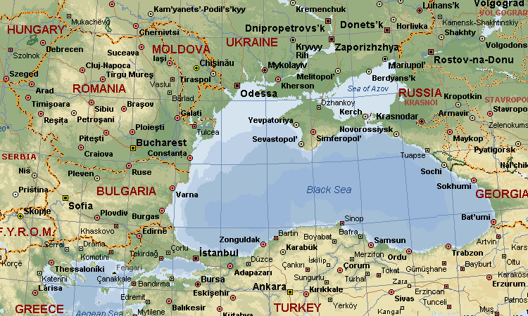 Mathematics and Electrical Engineering, wrote about the prehistoric flooding of a civilisation in the Caucasus region, which he linked with Plato’s Atlantis. The text of this extensive work is now available on the Internet(a).
Trevor Palmer has written a useful paper (2009) on the Black Sea and the gradual development of theories relating to its dramatic connection with the Mediterranean and how it may have influenced the mythologies of the Middle East and possibly further afield.
Palmer concluded that, “The various groups currently investigating the area are agreed that cataclysmic flooding took place during the Late Pleistocene, but remain divided about whether similar floods also occurred during the Holocene. Eye-witness accounts of catastrophic floods in the Black Sea basin at either time could have been passed on to future generations, eventually giving rise to the later Mesopotamian legend of Uta-napishtim and, subsequently, the Biblical story of Noah. However, in the absence of any direct evidence of cultural transmission, that can presently only be regarded as plausible speculation.”(p)
Little was heard of the region again, until 1998 when Ryan & Pitman identified the flooding of the Black Sea with Noah’s Flood[025]. This was followed in 2001, by Ian Wilson‘s Before the Flood [185], which reflected a similar line of thought.
In 2004, the Bulgarian father and son oceanographers, Petko and Dimitar Dimitrov published their book, The Black Sea, the Flood and the Ancient Myths, in English, which supported much of Ryan and Pitman’s work. Unlike them, who based much of their conclusions on a study of molluscs, the Dimitrovs focused on sedimentation evidence. Their book is now available, in English, as a free pdf file(d). They also suggest that this Holocene influx into the Black Sea triggered the Vedic Aryan migration to India(g).
In 2006, a short paper, with 11 authors that included Petko Dimitrov, William Ryan and Robert Ballard, noted how the Black Sea Flood was initially met with “great hostility” by Bulgarian scientists.
The paper considers “the most important scientific arguments in favor of the flood are as follows:
- The presence of the shelf periphery of an old shoreline that existed around 9,500-8,000 BP. The old shoreline is located at depths of 90-120 m.
- The existence of catastrophic-type deepwater organogenic-mineral sediments (sapropels) that are products of the catastrophe. A rapid change of macro- and microfauna from the brackish lake organisms that existed more than 8,000 years ago to typical marine organisms.
- The occurrence of hydrogen sulfide contamination, which resulted from the catastrophe.”
The authors also briefly touch on artifacts and legends associated with the Black Sea Flood and in reference to the latter they make the following unexpected comment – “Juxtaposing the data from the Black Sea’s natural events and archaeo-mythology, as well as the legend of Noah’s ark, we can claim with a high degree of reliability that the remains of the ark are located within the Black Sea bottom.”
Hristo Smolenov is another Bulgarian and a recognised expert in counter-terrorism and mathematics and is another advocate of a Black Sea Atlantis, which he identifies with what he calls the Aurolithic Varna Civilisation, that existed 3,000 years before the pyramids. Varna today is situated in the Bulgarian province of Stara Zagora on the Black Sea coast. He has publicised his views through a website(r), video(s) and a book [1003], Zagora – Varna: The Hidden Superculture.
Ryan and Pitman’s book unintentionally triggered the imaginations of a number of people into considering the possibility of a possible link between this inundation and the sinking of Atlantis. While Ryan and Pitman have made no such suggestion, others such as Ian Wilson[185] have seen a distorted memory of the event as a possible inspiration for Plato’s story. In 2009, a team led by Liviu Giosan, a geologist at the Woods Hole Oceanographic Institution, published a paper(e) which suggested that prior to the intrusion of the Mediterranean, the level of the Black Sea had been just 30 metres below its present level, rather than the 80 metres proposed by Ryan and Pitman. This would imply a less extensive degree of flooding than previously thought. Giosan has offered a sceptical Ryan an opportunity to replicate his tests. Furthermore, Giosan et al. also argue that the flood event took place around 7,400 BC, rather than the more generally accepted 5,600 BC. Additional criticism of Ryan and Pitman’s theories has come from Valentina Yanko-Hombach, a native of the region(y).
Although the scenario pictured by Ryan & Pitman and others is of very rapid flooding of the original smaller Black Sea, more recent studies appear to indicate a more gradual rising of the water levels. “With more data to be analysed, it supports the idea that the waters rose unnoticeably, by metres over centuries, even millennia.”(o)
Nick Thom, a British engineer, wrote The Great Flood [776] which includes a section on the Black Sea, in which he suggests that the flow of water was from the Black Sea into the Sea of Marmara, rather than the other way around.
Nearly two hundred years ago, Josiah Priest, in his 1835 book American Antiquities, [1143] also offered evidence from Euclid of Megara, that the flow of water had been from the Black Sea to the Aegean. Apparently, Euclid heard this from Anacharsis, a philosopher from the northern coast of the Black Sea who related how the inflow from the rivers of Europe and Asia raised the level of the ‘Sea’, until it breached the landbridge and spilled over into the Sea of Marmara.
Paul Dunbavin has entered the Black Sea flood(s) debate, with a 2020 paper entitled Diodorus Siculus and the Black Sea Flood(q). This lengthy essay covers a lot of ground, in particular the comments of Diodorus Siculus, who described a Samothracian flood story that appears to contradict the flood described by Ryan & Pitman, as it describes a flow of water in the opposite direction. Consequently, the evidence offered by Diodorus is often discounted as ‘unreliable’. Dunbavin, however, offers a possible solution with the suggestion that “The Samothracian flood, as described by Diodorus, could only have occurred after the Black Sea Flood.”
The question of whether the Black Sea Flood was from the east or the west, may be answered by consideration of Ronnie Gallagher’s claim of a vast post-glacial Eurasian sea, that included the Caspian and Ural Seas. Modern proponents of Atlantis in the Sea of Azov have suggested(t) that at the end of the last Ice Age, floods of meltwater poured into the Caspian Sea, which in turn, escaped through the Manych-Kerch Gateway,(u) into what is now the Sea of Azov, but at that time, contained the Plain of Atlantis and from there to the Black Sea proper! This theory suggests that the flooding came from the Black Sea into the Aegean.
A 2022 paper by A.E. Aksu, & R.N. Hiscott, has added a recent endorsement of the view that the flooded Black Sea flowed westward into the Aegean(w). The authors have consistently argued against the Noah’s Flood Hypothesis of Ryan and Pitman.
More recently, Christian & Siegfried Schoppe, two German researchers, have also asserted that the Black Sea was the original ‘Atlantis Ocean and that Atlantis was located in that region [186]. They have suggested that Snake Island, located east of the mouth of the Danube was the probable site of Plato’s city. Their contention is that around 5500 BC, a landbridge at the Bosporus was breached, causing extensive flooding that created what we now know as the Black Sea. Until that time, there had only been a small freshwater lake in the region. Although their book was published in German, the Schoppes have a website(b) with a useful amount of English content.
 The somewhat eccentric duo of the late Flying Eagle (1920-2007) and Whispering Wind, who also advocated a Black Sea location for Atlantis(a)(f), claimed a specific site on the Strait of Kerch, between the Black Sea and the Sea of Azov. Their theory was first expounded in their book [138] in 2004. They also followed the Ryan and Pitman date of 5500 BC for the inundation of the Black Sea, although they that the flooded sea broke INTO the Aegean, rather than the reverse.
The evidence to date suggests that the flooding of the Black Sea coincided with a storegga event, which would require a catastrophe on a scale not previously considered. In a 2017 paper(i), John M. Jensen offers a range of evidence to support this contention.
A rather different approach is taken by the German researcher, Werner E. Friedrich[695], who pushes back the expansion and the raising of the level of the Black Sea to around 10000 BC, at the end of the last Ice Age. He believes that this led to the flooding of Atlantis, which he claims to have been situated on a plain that had lain between ancient extensions of the rivers Donau and Don. Friedrich located the Pillars of Heracles in the Sea of Marmara[p.39].
A.I. Zolotukhin places Atlantis in western Crimea on his multilingual website, with the inviting title of Homer and Atlantis(j).
The legendary destroyed city of Ancomah ,is frequently compared to Plato’s description of the destruction of Atlantis. It was reputed to have existed in the vicinity of the ancient port city of Trabzon, which is located on the southeast coast of the Black Sea.
Michael A. Cahill in his 2012 two-volume[818][819] publication on the development of civilisation, locates Atlantis near what is modern Istanbul, in the pre-Diluvian Stone Age.
The concept of a Black Sea Atlantis has the support of the rather eccentric Church of Vrilology(h)!
In October 2018, an attempt was made to breathe new life into the idea of Crimea, as a remnant of an Atlantis submerged under the Black Sea. Unfortunately, it offers no evidence or references in the badly translated article(k). In the same month, it was reported that the oldest intact shipwreck was discovered in the Black Sea by an Anglo-Bulgarian team. It was identified as a Greek trading vessel, dated to 400 BC(l). The oxygen-free waters at the bottom of the Black Sea had preserved it and dozens of others located by the team.
In early 2019, George K. Weller, building on the theories of the Schoppes, also proposed the Black Sea as Atlantis’ home, again nominating Snake Island as the home of Mr. and Mrs. Poseidon, which, before the Black Sea was flooded, would have been the central peak of their island home, as referred to by Plato(n).
I note that there is a claim that the ancestral home of the Vigings was in the Black Sea region(x).
One of the most comprehensive internet papers on all aspects of the history of the Black Sea, can be found on the Encyclopaedia Iranica website(m).
(a) https://www.radiocom.net/Deluge/Deluge1-6.htm
(b) See: https://atlantipedia.ie/samples/archive-3914/
(d) http://io-bas.bg/noahproject/BOOK_PETKO.pdf
(e) Danube Delta Holds Answers To ‘Noah’s Flood’ Debate | ScienceDaily (archive.org)
(f) https://atlantis-today.com/Great_Atlantis_Flood.htm
(h) https://web.archive.org/web/20130108091223if_/https://www.vrilology.org/Atlantis_page.htm
(i) https://www.migration-diffusion.info/article.php?year=2017&id=505
(j) https://homerandatlantis.com/?lang=en
(k) https://ktelegram.com/scientists-crimea-may-be-a-fragment-of-the-lost-city-of-atlantis/43728/ (link broken Jan. 2019)
(m) BLACK SEA – Encyclopaedia Iranica (archive.org)
(o) (BBC Oct 22, 2019) https://www.bbc.com/travel/story/20191021-the-sea-of-60-ghostly-wrecked-ships
(q) e5604c_67fd983e0b934a56ac5b31ee9dd1f41e.pdf (third-millennium.co.uk)
(r) https://atlantisblacksea.wordpress.com/tag/hristo-smolenov/
(s) https://atlantisblacksea.wordpress.com/atlantis-in-the-black-sea-videos/
(t) https://atlantis-today.com
(u) Wayback Machine (archive.org)
(v) (PDF) The Flood in the Black Sea – Science and Mythology (researchgate.net)
(x) Ancestral Roots of the Vikings (redqueenwhitequeen.com)
(y) C:\Documents and Settings\gilbert\Desktop\BLACK SEA FINAL\149Yanko-Hombach1.wpd (onu.edu.ua) (link broken)
Russia
Russia went through a phase, during the Stalinist years when it claimed that every major invention had been the result of Russian ingenuity and a clear demonstration of the superiority of the Soviet system. Included on the list were the radio (did you not know that Marconi was Russian?), the telephone, television and the lightbulb!(c) However, their outlandish claims went beyond science and technology when they also claimed to have possessed Atlantis, which is now covered by the Caspian Sea!
Today, (pre annexation of Crimea) Russia has just a short coastline on the Black Sea another proposed location for Atlantis. Flying Eagle and Whispering Wind, who are proponents of this theory(a), claim a specific site on the Strait of Kerch between the Black Sea and the Sea of Azov. They claim(b) that there is evidence that the Kopet-Dagh fault line, which runs just above the strait, experienced a devastating (8.9) earthquake around 9600 BC, destroying Atlantis in the Strait. At this time, what we now call the Sea of Azov was the well-irrigated plain adjacent to the city of Atlantis described by Plato. They claim that the earthquake caused a massive influx of water from the Caspian Sea, which has been rising due to the melting ice caps in the north. This combination caused the creation of the Sea of Azov and the flooding of Atlantis.
The more conventionally named Christian & Siegfried Schoppe have also opted for the Black Sea as the home of Atlantis, but have identified a different mechanism for its destruction, namely the breaching of the Bosporus around 5500 BC.
Marco Bulloni has also opted for a Russian Atlantis but has identified it further north, just a hundred miles south of the Arctic Circle on the Solovetsky archipelago in the White Sea.
(a) https://web.archive.org/web/20230215193619/http://atmo.info/ *
(b) https://atlantis-today.com/Atlantis_Great_Atlantis_Flood.htm