Latest News

Joining The Dots
I have now published my new book, Joining The Dots, which offers a fresh look at the Atlantis mystery. I have addressed the critical questions of when, where and who, using Plato’s own words, tempered with some critical thinking and a modicum of common sense.Read More »
Pliny the Elder
Red Sea
The Red Sea, also known as the Erythraean Sea, lies between Egypt and Sudan in Africa and Saudi Arabia and Yemen in Asia.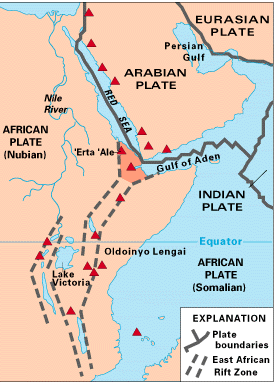 At the southern end lies the strait of Bab-el-Mandeb, considered by a few researchers as the location of the Pillars of Herakles.
Pliny the Elder refers to ‘Pillars’ at the end of the Red Sea and then, without pause, inexplicably mentions, Mauritania, Mt. Atlas and Cerne and shortly afterward to an island known as Atlantis!(c)
The Red Sea has entered the Atlantis debate mainly because the biblical Exodus has been linked with the 2nd millennium BC eruption of Thera and in turn to the Minoan Hypothesis. Unfortunately, a variety of dates are on offer for the time of the Exodus, which failed to help us pinpoint the date of the eruption, or enable the Minoan Hypothesis to provide a definitive date for the destruction of Atlantis.
For many, the Red Sea is associated with the biblical Exodus. However, the term used to describe it in the Hebrew text is ‘yam suph’, which does not mean Red Sea but ‘Sea of Reeds’ that left generations of bible students looking in the wrong place for evidence of the Exodus. Even the ‘Sea of Reeds’ explanation has been disputed in a paper by Bernard F. Batto on the Biblical Archaeology website(h). Consequently, researchers have turned their attention to other possible locations.
One example is a paper offered by Gary Byers, who concluded that today’s Ballah Lake in the northeast Nile, is the Exodus crossing point! However, the search is not over.
The ‘Red’ is often attributed to the seasonal blooming of a red-coloured bacterium. Some academics think that the cardinal points were ascribed colours, ‘red’ being south! Emilio Spedicato, in his paper(a) on the location of the biblical Ophir, points out that pinkish pumice, which is normal volcanic ejecta, can turn-red when iron within it is mixed with steam and oxygen.
Coincidentally, the presumed cradle of humanity is situated not too far from the Rift volcanoes and has drawn serious claims(b) that they may have played a part in the evolution of hominids!
The oldest known map of the Red Sea, referred to as the Nuzi Map, has its origins traced back to 120 years before the Flood of Noah(d)! George & Dana Brown, a father and son team from Florida, refer to the Red Sea as the Edenic Valley, to the east of which, in northwest Saudi Arabia, Cain’s city of Chanoch had lain and also where, according to the Browns, Noah’s Ark landed(f)!
(a) https://2010-q-conference.com/ophir/ophir-27-10-09.pdf
(b) https://www.seeker.com/volcanic-eruptions-led-to-emergence-of-first-humans-2052178636.html
(d) http://web.archive.org/web/20240413034120/https://www.angelfire.com/fl/BriansHouse/nuzimap.html
(h) Red Sea or Reed Sea? – The BAS Library (biblicalarchaeology.org)
Hanno, The Voyage of
The Voyage of Hanno, the Carthaginian navigator, was undertaken around 500 BC. The general consensus is that his journey took him through the Strait of Gibraltar and along part of the west coast of Africa. A record, or periplus, of the voyage was inscribed on tablets and displayed in the Temple of Baal at Carthage. Richard Hennig 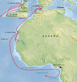 speculated that the contents of the periplus were copied by the Greek historian, Polybius, after the Romans captured Carthage. It did not surface again until the 10th century, when a copy, in Greek, was discovered (Codex Heildelbergensis 398) and was not widely published until the 16th century.
The 1797 English translation of the periplus by Thomas Falconer, along with the original Greek text, can be downloaded or read online(h).
Edmund Marsden Goldsmid (1849-?) published a translation of A Treatise On Foreign Languages and Unknown Islands[1348] by Peter Albinus. In footnotes on page 39 he describes Hanno’s periplus as ‘apocryphal’. A number of other commentators(c)(d) have also cast doubts on the authenticity of the Hanno text.
Three years after Ignatius Donnelly published Atlantis, Lord Arundell of Wardour published The Secret of Plato’s Atlantis[0648] intended as a rebuttal of Donnelly’s groundbreaking book. The ‘secret’ referred to in the title is that Plato’s Atlantis story is based on the account we have of the Voyage of Hanno.
Nicolai Zhirov speculated that Hanno may have witnessed ‘the destruction of the southern remnants of Atlantis’, based on some of his descriptions.
Rhys Carpenter dedicated nearly twenty pages to the matter of Hanno, commented that ”The modern literature about his (Hanno’s) voyage is unexpectedly large. But it is so filled with disagreement that to summarize it with any thoroughness would be to annul its effectiveness, as the variant opinions would cancel each other out”[221.86]. Carpenter included what he describes as ‘a retranslation of a translation’ of the text.
Further discussion of the text and topography encountered by Hanno can be read in a paper[1483] by Duane W. Roller.
What I find interesting is that so much attention was given to Hanno’s voyage as if it were unique and not what you would expect if Atlantic travel was as commonplace at that time, as many ‘alternative’ history writers claim.
However, even more questionable is the description of Hanno sailing off “with a fleet of sixty fifty-oared ships, and a large number of men and women to the number of thirty thousand, and with wheat and other provisions.” The problem with this is that the 50-oared ships would have been penteconters, which had limited room for much more than the oarsmen. If we include the crew, an additional 450 persons per ship would have been impossible, in fact, it is unlikely that even the provisions for 500 people could have been accommodated!
Lionel Casson, the author of The Ancient Mariners[1193] commented that “if the whole expedition had been put aboard sixty penteconters, the ships would have quietly settled on the harbour bottom instead of leaving Carthage: a penteconter barely had room to carry a few days’ provisions for its crew, to say nothing of a load of passengers with all the equipment they needed to start a life in a colony.“
The American writer, William H. Russeth, commented(f) on the various interpretations of Hanno’s route, noting that “It is hard for modern scholars to figure out exactly where Hanno travelled, because descriptions changed with each version of the original document and place names change as different cultures exert their influence over the various regions. Even Pliny the Elder, the famous Roman Historian, complained of writers committing errors and adding their own descriptions concerning Hanno’s journey, a bit ironic considering that the Romans levelled the temple of Ba’al, losing the famous plaque forever.”
George Sarantitis has a more radical interpretation of the Voyage of Hanno, proposing that instead of taking a route along the North African coast and then out into the Atlantic, he proposes that Hanno travelled inland along waterways that no longer exist(e). A 2013 report in New Scientist magazine(n) revealed that 100,000 years ago, the Sahara had been home to three large rivers that flowed northward, which probably provided migration routes for our ancestors. Furthermore, if these rivers lasted into the African Humid Period, they may be interpreted as support for Sarantitis’ contention regarding Hanno!
He insists that the location of the Pillars of Heracles, as referred to in the narrative, matches the Gulf of Gabes [1470].
The most recent commentary on Hanno’s voyage is on offer by Antonio Usai in his 2014 book, The Pillars of Hercules in Aristotle’s Ecumene[980]. He also has a controversial view of Hanno’s account, claiming that in the “second part, Hanno makes up everything because he does not want to continue that voyage.” (p.24) However, the main objective of Usai’s essays is to demonstrate that the Pillars of Hercules were originally situated in the Central Mediterranean between eastern Tunisia and its Kerkennah Islands.
A 1912 English translation of the text can be read online(a), as well as a modern English translation by Jason Colavito(k).
Another Carthaginian voyager, Himilco, is also thought to have travelled northward in the Atlantic and possibly reached Ireland, referred to as ‘isola sacra’. Unfortunately, his account is no longer available(g).
The controversial epigrapher Barry Fell went so far as to propose that Hanno visited America, citing the Bourne Stone as evidence!(m)
The livius.org website offers three articles(i) on the text, history and credibility of the surviving periplus together with a commentary.
Another excellent overview of the document is available on the World History Encyclopedia website.(l)
(a) https://web.archive.org/web/20040615213109/https://www.jate.u-szeged.hu/~gnovak/f99htHanno.htm
(c) https://en.wikipedia.org/wiki/Hanno_the_Navigator
(d) https://annoyzview.wordpress.com/2012/04/
(e) https://platoproject.gr/voyage-hanno-Carthaginian/
(f) https://www.goodreads.com/author/show/1033187.William_H_Russeth/blog?page=2
(g) https://gatesofnineveh.wordpress.com/2011/12/13/high-north-carthaginian-exploration-of-ireland/
(j) BSMQgoYSQYFJ90bRJIhQ&hl=mt&ei=–tuSfNEIaqnAOo_NjHBA&sa=X&oi=book_result&ct=result&resnum=&ved=CBgQ https://archive.org/details/cu31924031441847
(l) Hanno: Carthaginian Explorer – World History Encyclopedia
(n) NewScientist.com, 16 September 2013, https://tinyurl.com/mg9vcoz
Ghembaza, Thérêse
Thérêse Ghembaza is a French researcher who has a website, in French and English, entitled The Great Enigmas of Antiquity(a) in which she discusses matters such as the Hyksos, the identity of Moses and the Kushites. The site also addressed her theory that Atlantis had been situated in Meroë on the Upper Nile, a theory that she developed in a number of other papers(c), which are certainly worth a read.
While at first sight this might be seen as a wild claim, Ghembaza offers a well-reasoned theory which was presented to the 2nd Atlantis Conference held in Athens in 2008. She has imaginatively linked aspects of Meroitic geography and history with Plato’s story of Atlantis. For example, she identifies Tyrrhenia with Tyre in Lebanon and claims that Tyrrhenia in Italy was a later colony of Tyre! While some of her ideas are convincing, I found others a little threadbare. Nevertheless, Ghembaza must be applauded for her efforts to construct a scientific explanation for the Atlantis narrative.
Although Ghembaza quotes Plato extensively to support her Meroë hypothesis, she fails to explain how an Atlantean Meroë, situated on the Upper Nile, had territory in Southern Italy and northeast Africa (Tim 25a-b & Crit 114c), a distance of around 4,000 km. Equally difficult to account for is the fact that Meroë did not exist until sometime early in the 1st millennium BC, in contrast to the middle of the 2nd millennium, considered a reasonably late date for the destruction of Atlantis. Add to that, the fact that Meroë was never submerged or created ‘shoals of mud’, leaving the credibility of Ghembaza’s Atlantis claims in tatters.
On her homepage, Ghembaza has a link in which she claims that in his Periegesis(b) Hecateus of Miletus provided some of the details used by Plato in his Atlantis narrative.
In April 2015, Ghembaza offered a short paper(d) in support of identifying Bab-el-Mandeb as the location of the Pillars of Heracles.
Ghembaza has kindly drawn my attention to two quotations from Pliny the Elder and Ovid, which offer possible explanations for Plato’s orichalcum (see Document 091011). The former refers to a Cypriot copper mixed with gold, which gave a fiery colour and is called pyropus, while Ovid also refers to a cladding of pyropus, a term often translated as bronze. She also mentions auricupride(Cu3Au), an alloy that may be connected with orichalcum.
A lecture outline by Ghembaza with a slideshow can be accessed online(e).
(a) http://antiqua91.fr/index_en.html
(b) Hecataeus of Miletus‘ Periegesis 550 – 480 “now lost, but probably the main source of Plato and Eratosthenes”
(c) http://antiqua91.fr/atlantis_en.html
(d) See: Archive 2526
(e) https://slideplayer.com/slide/3878434/ (link broken)
Strait of Gibraltar
The Strait of Gibraltar according to Greek mythology was created by Herakles. Neville Chipulina explains that “it seems that the person responsible for the myths about Hercules was Peisander of Rhodes, a 7th century BC Greek epic poet who apparently got the story from an unknown Pisinus of Lindus who almost certainly plagiarised it from somebody else. In other words, it’s a pretty old story.”(c)
The Strait is very much a part of many current Atlantis theories. Primarily, it is contended that the region itself held the location of Atlantis. This is based on Plato’s statement that Eumelos, also known as Gadeirus, the twin brother of Atlas the first king of Atlantis gave his name to Gades, known today as Cadiz. Andalusia in Southern Spain has been the focus of attention for over a hundred years. In recent years Georgeos Diaz-Montexano and his rival Jacques Colina- Girard have been investigating the waters of the Strait itself while south of the Strait Jonas Bergman has advanced his theory that Atlantis was located just across the Strait in Morocco.
Although there is general acceptance that the Pillars of Heracles had their final resting place in the vicinity of the Strait of Gibraltar, it must be noted that there have been other candidates at different times with equally valid claims. The location of the ‘Pillars’ referred to by Plato at the time of Atlantis is the subject of continuing debate.
Archaeologist Josho Brouwers has noted that(g) “according to Strabo (3.5.5), Hercules raised the Pillars during one of his Twelve Labours to mark the western edge of the inhabited world. One pillar was identified as the Rock of Gibraltar (called Mount Calpe in ancient times), with the other was Ceuta (Mount Abile) on the African side of the narrow strait.
Diodorus Siculus mentions that Hercules put the Pillars in place as a monument to himself (4.18.4). He also adds that Hercules either narrowed the passage in order to prevent sea-monsters from the Atlantic to enter the Mediterranean, or to actually open the mountain so that the Atlantic could mingle with the Mediterranean. On this issue, as Diodorus puts it, “it will be possible for every man to think as he may please” (4.18.5).” For me it raises a warning flag regarding the hasty acceptance of ancient myths and traditions as having an historical basis.
Strato, the philosopher, quoted by Strabo, spoke of a dam separating the Atlantic and the Mediterranean being breached by a cataclysm. This idea was reinforced by comments of Seneca. Furthermore, a number of Arabic writers, including Al-Mas’udi, Al-Biruni and Al-Idrisi, have all concurred with this idea of a Gibraltar land bridge in late prehistory.
A more radical theory is that of Paulino Zamarro who contends that the Strait was in fact closed by a landbridge during the last Ice Age because of the lower sea levels together with silting. When the waters rose and breached the landbridge, he believes that the flood submerged Atlantis, which he situates in the Aegean. Others support Zamarro’s idea of a Gibraltar Dam amongst whom are Constantin Benetatos and Joseph S. Ellul.
Terry Westerman on his heavily illustrated website surveys impact craters globally. He suggests that “The Strait of Gibraltar was formed by two meteor impacts. The first blasted the round area in the western Mediterranean Sea to form a land bridge between Spain and Morocco.” He maintains that a second impact broke the landbridge around 5.33 million years ago, creating what is called the Zanclean Flood which refilled the then desiccated Mediterranean(d).
A German-language website(a) presented some of the following data+, apparently recording the dramatic widening of the Strait of Gibraltar between 400 BC and 400 AD. The same list was included in the ‘Strait of Gibraltar’ entry of the German Wikipedia(b) until a few years ago. It has since been removed.
Alexander Braghine offered [156.139] similar data*, which, unfortunately, is also unreferenced.
+Damastes of Sigeum, circa 400 BC. – about 1.3 km
+Pseudo-Skylax, probably fourth Century BC – about 1.3 km
*Turiano Greslio? 300BC – 8.0 km
*+Titus Livius (Livy) 59 BC- 17 AD – 10.5 km
+Strabo 63 BC- 24 AD – from 9.5 to 13.0 km
+Pomponius Mela , 50 AD – about the 15.0 km
+Pliny the Elder, 50 AD – about 15.0 km
*+Victor Vicensa (*Vitensa?), 400 AD – about 18 km
Procopius, 550 AD – about 15.0 km
The above figures suggest that in the latter half of the first millennium BC, the Strait of Gibraltar was gradually widened. However, the figures given suggest that between 400 and 550 AD the Straits narrowed again seems absurd. Nevertheless, until the methods used and all the data on offer have been verified, the idea must be treated with great caution.
My list had originally included Euctemon, the 5th century BC Athenian astronomer, however, Werner E. Friedrich notes that Euctemon was referring to the Sea of Marmara near the entrance to the Black Sea [0695.38].
However, more recently, John Jensen Jnr. has offered a comparable, if shorter, number of dates showing the reducing width of the strait the further back you go, from which he extrapolated that around 3450 YBP when he believes that a landbridge there was breached(e).
Jensen’s estimated widths for the strait are without references, but suggest a similar story of a gradually widening entrance to the Mediterranean.
1,100 BC 2 Miles (3.2 km}
480 BC 4 Miles (6.5 km
60 BC 7 Miles (11.2 km)
1200 AD 12 Miles (19.3 km)
Now 15 Miles (24 km)
Georgeos Diaz-Montexano has also referred to the descriptions by ancient writers of the Strait of Gibraltar indicating a width of around two kilometres. Unfortunately, he does not cite references(f). He is also sympathetic to the existence of an earlier landbridge at Gibraltar.
(a) https://de.academic.ru/dic.nsf/dewiki/1337738
(b) https://de.wikipedia.org/w/index.php?title=Stra%C3%9Fe_von_Gibraltar&oldid=60093153
(c) https://gibraltar-intro.blogspot.ie/2015/10/bc-pillars-of-hercules-if-ordinary.html
(d) The Formation of the Strait of Gibraltar (archive.org)
(e) https://www.migration-diffusion.info/article.php?id=514 and https://www.linkedin.com/pulse/earths-axis-tilt-john-jensen-jr-
(f) https://web.archive.org/web/20200630064033/http://freerepublic.com/focus/f-news/1011563/posts
(g) The Pillars of Hercules – Ancient World Magazine
Scilly Isles
The Scilly Isles are located southwest of Cornwall’s Land’s End in the Atlantic Ocean. The islands were more extensive before the end of the last Ice Age and their inundation following the melting of the glaciers undoubtedly produced numerous legends in the region of sunken cities and lost civilisations. Apparently, there was once a paved causeway joining some of the islands and according to an 18th-century report, it was then under 8 feet of water. Even earlier in the 3rd century AD, Solinus referred to the Scillies in the singular as insulam Siluram.
O.G.S. Crawford, who was the first Archaeology Officer with the British Ordnance Survey, was also the founder in 1927 of Antiquity, which continues today. In its first edition(c) he wrote of the earlier Scillies as a single landmass and its relationship to the legend of Lyonesse(b).
 Some writers have identified the Scillies as the Cassiterides (Isles of Tin) referred to by Pliny the Elder. However, there are no known tin deposits on the islands, although it is possible that, before the ocean levels rose ore deposits were accessible, similar to those in nearby Devon and Cornwall. This inundation probably occurred before the technology existed to exploit its use.
A popular view is that the mythical sunken land of Lyonesse was situated between the Scillies and Land’s End in Cornwall. This is often seen as a parallel with the Breton legend of Ys.
In more recent times, the Russian Scientist Viatcheslav Koudriavtsev was convinced that Atlantis was located on the Celtic Shelf near the Scilly Isles. He specifically identified an underwater feature known as the Little Sole Bank, whose highest point is just 75 metres beneath the ocean’s surface. He had been promoting his theory since 1995 and eventually obtained official government permission to carry out explorations in the area, but he was unable to raise the necessary funds to carry out the operation.
In 2009, excavations on St. Agnes in the Scillies revealed a remarkable Bronze Age pottery sherd which seems to depict the earliest known image of a sailing boat ever found in the United Kingdom(a).
In 1651, the Netherlands declared war on the Scillies, a little detail that was forgotten until 1986, when a peace treaty was finally signed(d) !
(c) https://www.cambridge.org/core/journals/antiquity/article/lyonesse/37725F1992B3D4ADF36561E144227F11 (Jan. 2019 access restricted)
(d) https://en.wikipedia.org/wiki/Three_Hundred_and_Thirty_Five_Years%27_War
São Tomé and Príncipe
São Tomé and Príncipe are two islands in the Gulf of Guinea, off the coast of the West African state of Gabon. The website(a) dedicated to the work of Livio Stecchini unequivocally identifies São Tomé as the island of Atlantis referred to by Pliny the Elder (VI 36, 199).
>(a) https://web.archive.org/web/20190416084610/http://www.metrum.org/mapping/atlantis.htm<
Pliny the Elder
Pliny the Elder (23 -79 AD), or more correctly, Gaius Plinius Secundus, was a Roman writer and naturalist whose only extant work  is the 37 volume Historia Naturalis, considered to be the first encyclopaedia. It was Pliny the Elder who was credited with saying “that the only certainty is that nothing is certain.”
Pliny makes a number of references to Atlantis that gives us small clues to add to the writings of Plato. Jürgen Spanuth quotes Pliny where he recorded (vi.49) how in Sogdiana, in today’s Uzbekistan, there was reputed to have been an altar and ‘Pillars of Heracles’. Pliny also describes (vii.56) the encounter between the Athenians and Atlanteans as the first recorded battle. Interestingly, he also refers to this conflict being fought with wooden sticks hardened by fire, since they did not have iron. We can also infer from this comment that they did not have bronze either, thus setting the war in the Stone Age. Pliny’s comment would therefore place this event somewhere between 4000 BC and 2000 BC.
Anton Mifsud notes[209] how, over the centuries, various versions of Pliny’s text have been guilty of omissions and amendments. Pliny refers to Atlantis on several occasions, but individual translations have omitted different references to ‘Atlantis’, ‘the islands of Atlantis’ and the Atlantic Sea. While it is accepted that Pliny’s writings do contain errors such arbitrary meddling with the text by translators does little to inspire confidence in the average reader!
Pliny, in his remarks on the islands off the west coast of Africa, notes there was an island ‘off Mount Atlas’ called Atlantis (vi.36).
Intriguingly, Pliny describes Italy as being shaped like an oak leaf (iii.43), an image that inspired Camillo Ravioli to produce a matching speculative map of ancient Italy.
According to Pliny, Atlantian was the name that was applied to all Ethiopians, including some known as White Ethiopians. In turn Ethiopians was a term applied to all Africans.
Pliny died, after being overcome by fumes while trying to study the 79 AD eruption of Vesuvius.
Hesperides
The Hesperides in Greek mythology were the daughters of Atlas. They lived on an island in the far west guarding a tree that bore golden apples, made famous in the story of the twelve labours of Hercules who was charged with obtaining some of the apples.
The Hesperides have also been referred to as the Fortunate Islands and is the name applied by classical writers to islands off the west coast of Africa that have been variously identified with the Azores, Canaries or Cape Verde islands. Other opinions place the garden at Gades or on the Atlantic coast of Morocco, such as Pliny’s suggested location of Lixus(b).
According to Wikipedia “the Sicilian Greek poet Stesichorus, in his poem the “Song of Geryon”, and the Greek geographer Strabo, in his book Geographika (volume III), the garden of the Hesperides is located in Tartessos, a location placed in the south of the Iberian peninsula.”(c)
Gonzalo Fernández de Oviedo y Valdés writing in the 16th century [1117] considered the Antilles in the Caribbean to have been the legendary Isles of Hesperides.
While the majority opinion is that the name specifically refers to the Canaries, a minority view espoused by Andrew Collins[072](a) is similar to that of Oviedo, namely that Hesperides refers to the Caribbean, where he is convinced that Cuba had been the home of Atlantis.
Reginald Fessenden argued that the Hesperides lay in the east not the west in chapter one of his The Deluged Civilization of the Caucasus[1012].
(a) https://www.grahamhancock.com/phorum/read.php?f=1&i=122922&t=122922
(b) Pliny the Elder. Historia Naturalis – Book V.
Guanches
Guanches and Canarios were the names given to the natives of the Canary Islands when conquered by the Spanish in the 15th century, following a hundred-year campaign. They are generally considered to be of Cro-Magnon origin, having fair or red hair and blue/grey eyes, characteristics that are still to be seen today. Many writers have been convinced that the Guanches were the remnants of the Atlantean civilisation, a belief noted by W.G. Wood-Martin over a century ago [388.1.212]+. Recent DNA studies(j) reveal a diversity of origins for the descendants of Guanches, comparable with the general Canarian population today.
However, a number of recent genetic studies(l)(m) have established a clear relationship with the Berbers of North Africa, probably mountain Berbers(z). Furthermore, it is claimed that the aboriginal language of the Guanches is related to one of the Berber dialects(n). A curiosity in use today is a whistling language known as Silbo Gomera, used to communicate over rough terrain. This is currently taught in schools and is recognised by UNESCO as an intangible cultural heritage.
Further evidence favouring a Berber connection was provided in 2017(o). A 2018 paper develops this further with particular reference to the Lybico-Berber script(p).
A review of our current knowledge of the early Canarians was published in February 2024 on the science.org website(aa) “European archaeologists were fascinated with the early Canarians. The French thought the first settlers were Cro-Magnon, like prehistoric people in France; German archaeologists thought they must have been Aryan; the Spanish thought they were Stone Age relatives of the same North Africans who settled the Iberian Peninsula.
By analyzing ancient DNA from radiocarbon-dated bones, archaeologists in the past 15 to 20 years have found that the first islanders had the strongest genetic ties to the Amazigh cultures of northwestern Africa, also known as Berbers. Rock inscriptions on the islands also echo Amazigh alphabets.”
Prior to the arrival of the Europeans, it is claimed that the population numbered over 20,000. It is not commonly known that in the 15th century, many of the Guanches were abducted and brought to the Madeiras to work as slaves(g).
The Guanches were reported to have had no boats or maritime heritage. If they were all that was left following a catastrophic event, the Guanches were probably the descendants of mountain people who had no seagoing heritage. This view was queried by Henry Eichner who claims that this idea was generated by the faulty assumptions of one of the first Spaniards to visit the island, Nicoloso de Recceo. In 2013, Sergio Navio decided to disprove this notion with a practical demonstration. The plan is to use a basic raft-like boat, named ‘Ursa Minor’, to sail from Lanzarote to La Palma, a distance of 250 miles(f).
The Spanish conquerors of the Canary Islands may have been able to shed more light on the subject, had they been more interested in history than in territory. According to these early explorers, the natives were surprised to learn that other people had survived the disaster that had flooded their world and submerged much of their homeland. They excitedly asked the conquistadors for help translating ancient inscriptions left by their ancestors that they could no longer read, but unfortunately, – for the natives and for history, – the Spanish exterminated their tribe before any more information was learned about their history and legends. Their inscriptions remain undeciphered.
The Guanches have been linked with both ancient Egypt and America on a number of grounds, including similar methods of mummification(i) and the step pyramids found at both locations(d). In a 2020 documentary(y)and subsequent review(x) the mummification procedures of the Guanches were investigated in minute detail.
Perhaps the most radical idea to emerge in recent times from Jonah G. Lissner was the suggestion that the Guanches, or more correctly, their ancestors, were the founders of predynastic Egypt(q). In a similar vein, Helene E. Hagan wrote The Shining Ones[660], in which she identified the Tamazigh, related to the Guanches, as the founders of Egyptian civilisation.
Reinhard Prahl has published a paper(k) on the Migration & Diffusion website in which he also highlights cultural similarities of the Guanches and ancient Egyptians.
In The Atlantis Encyclopedia [104.130], Frank Joseph wrote, “In 45 A.D., he (Marcellus) recorded that “the inhabitants of the Atlantic island of Poseidon preserve a tradition handed down to them by their ancestors of the existence of an Atlantic island of immense size, of not less than a thousand stadia [about 115 miles], which had really existed in those seas, and which, during a long period of time, governed all the islands of the Atlantic Ocean.” Pliny the Elder seconded Marcellus, writing that the Guanches were in fact the direct descendants of the disaster that sank Atlantis. Proclus reported that they still told the story of Atlantis in his day, circa 410 A.D.” Joseph expanded on some of this in an article in issue #34 of Atlantis Rising(u).
José Luis Concepción (1948- ), a Canarian, has written a number of books with a local theme, including The Guanches, Survivors and their Descendant [825], a booklet providing a brief history of the islands. He concurs with the view that the Guanches have an African Cro-Magnon ancestry and are related to modern Berbers. The author also claims that the Guanches are still the dominant race on the Canaries. The booklet has been translated into a number of languages and includes an extensive Spanish bibliography.
A website(a) discussing the Guanches has some interesting, if controversial, suggestions regarding their origins. Another site highlights a possible connection with the Dravidians of Southern India(c). This Dravidian connection is supported by the late Edo Nyland(e) in his Linguistic Archaeology[1190]. Some time ago, Arysio dos Santos wrote a paper, claiming that “we provide linguistic evidence that the Guanche language is very likely of Dravidian derivation, and not indeed Hamito-Semitic, as usually stated(v). The present article is intended to be read in connection with the one entitled: The Mysterious Origin of the Guanches(w).”
Two Russian writers, B.F. Dobrynin[347] and B. L. Bogaevsky[182] in the first quarter of the 20th century wrote articles that supported the idea that there were links between the Guanches and the original Atlanteans.
A 2020 article(t) on the BBC website reiterates the Guanche – Berber connection, but adds that “They adapted caves and grottoes to be used as silos and temples. Some of those structures have been preserved to this day and indicate the Guanches’ sophisticated astronomical knowledge: holes on the caves’ walls allowed sunlight in at certain positions during different times of the year, marking solstices and equinoxes.”
[388.1.212]+ https://archive.org/details/traceselderfait00martgoog
(a) https://www.bibliotecapleyades.net/esp_guanches_1.htm
(c) https://ositorojo.blogspot.com/2009/12/mystery-of-guanches.html
(e) https://web.archive.org/web/20190605101058/https://faculty.ucr.edu/~legneref/bronze/guanche.htm
(f) https://www.abc.es/local-canarias/20131110/abci-navegar-guanches-lanzarote-lapalma-201311091742.html
(g) https://menceymacro.blogspot.ie/2013/08/la-punta-del-sol-la-historia-de-los.html (Spanish)
(i) See Archive 2617
(j) https://web.archive.org/web/20190620152221/https://www.nature.com/articles/5201075
(k) https://www.migration-diffusion.info/article.php?id=96
(l) https://phys.org/news/2017-10-guanches-north-africa-dna-study.html
(m) https://www.sciencedaily.com/releases/2017/10/171026135349.htm
(p) https://journals.openedition.org/corpus/2641
(q) https://joe3998.tripod.com/guanches/ (link broken)
(r) The Mysterious Origin of the Guanches | Atlantis (archive.org)
(s) http://www3.interscience.wiley.com/cgi-bin/abstract/39792/Abstract (Link Broken)
(t) (BBC May 29, 2020) https://www.bbc.com/travel/story/20200528-the-guanches-spains-mysterious-mummies
(u) Atlantis Rising magazine #34 http://pdfarchive.info/index.php?pages/At
(v) Guanche language derived from Dravida? | (archive.org)
(w) The Mysterious Origin of the Guanches | (archive.org)
(x) https://www.ancient-origins.net/history/guanche-mummies-0015257
(z) https://www.irishexaminer.com/opinion/columnists/arid-20228475.html
(aa) How did humans survive alone for 1000 years on desert islands off Africa? | Science | AAAS
Ethiopia
Ethiopia, as a geographical area, had very different meanings depending on the period in which it was used. Frank Joseph stated[102] that until the 1st century BC. Ethiopia refers to the Atlantic coast of North Africa. Zhirov claimed that ‘Ethiopia’ simply meant a land inhabited by dark-skinned people[0458.98].
Pliny the Elder stated that Aethiopia was formerly called Atlantia (p. 116). Proclus, the Greek philosopher, was convinced that 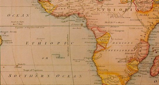 Atlantis existed and was connected with ancient Ethiopia, quoting The Ethiopian History of Marcellus.
Col. Alexander Braghine believed[156] in a connection between the ancient Ethiopians and Atlantis. The map above dating from 1650 and published in a book[292] by J.A. Rogers shows the South Atlantic as ‘The Ethiopic Ocean’, while the entire Central Africa is named Ethiopia. We can only conclude that the location of the original Ethiopia is nearly as difficult to pinpoint as the location of Atlantis itself.
In 1936, D. Duvillé suggested[284] that there had been two Atlantises – one in the Atlantic and one in Ethiopia.
It might be worth noting that in Greek mythology, Poseidon was given two Ethiopias, one in the east and the other in the west.
In 2020, African author George Mac D Lynch published Ethiopia is Atlantis and has made it freely available on the Internet Archive.(a) Lynch has been greatly influenced by the writings of Ignatius Donnelly, Drusilla Dunjee Houston and Gerald Massey. He claims Ethiopia as the cradle of civilisation.
2026 brought additional support for the idea of an Ethiopian location for Atlantis. In an article(b) by Diogo Sennfelt the volcanic Afar Depression is specified by him as the home of Plato’s lost civilisation. His ideas are more fully expounded in a multi-volume publication, Codex Atlantis [2127] and Atlantis in Ethiopia [2133].
(a) https://archive.org/details/ethiopia-is-atlantis-george-mac-d-lynch/mode/2up