Latest News

Joining The Dots
I have now published my new book, Joining The Dots, which offers a fresh look at the Atlantis mystery. I have addressed the critical questions of when, where and who, using Plato’s own words, tempered with some critical thinking and a modicum of common sense.Read More »
Landbridge
Iceland
Iceland has occasionally entered the Atlantis debates. Jean Silvain Bailly and more recently Gilbert Pillot 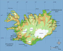 have identified Iceland with Ogygia. Some have linked the island with Thule or Hyperborea, while others see it as a remnant of a transatlantic landbridge. Harry Dale Huffman has similar ideas but believes that the landbridge also held Atlantis.
A recent commentator, Johan Nygren, also considered Iceland, when occupied by Cro-Magnon Man, to have been home of Atlantis(a)(b). This he followed with another paper drawing attention to the similarities between a map of Greenland and the famous 17th-century map of Atlantis published by Athanasius Kircher. More confusion was caused by an earlier document(c) in which he decided that South America was Atlantis and has since had it removed from the internet!
Another recent advocate for an Icelandic location is June Austin in a lengthy blog, which wanders all over the place, including the claim that a disproportionately large number of Icelandic people have psychic abilities(d). Sadly, she offers nothing but speculation to support her theory.
(a) https://steemit.com/atlantis/@johan-nygren/iceland-as-atlantis-2-0
(c) Having discovered the myth of Atlantis in the past days, I’ve now conformed to that it described South America (“Isla Atlantica”) — SteemKR (archive.org) (link now broken!)
Landbridges
Landbridges, in biogeography are described by Wikipedia as “an isthmus or wider land connection between otherwise separate areas, over which animals and plants are able to cross and colonize new lands. A land bridge can be created by marine regression, in which sea levels fall, exposing shallow, previously submerged sections of continental shelf; or when new land is created by plate tectonics; or occasionally when the sea floor rises due to post-glacial rebound after an ice age.”
In the distant past, landbridges are believed to have played a critical part in early human migration. Similarly, 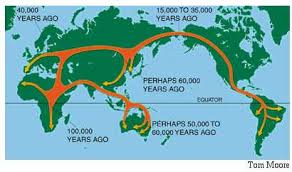 landbridges, both real and speculative, are important components in many Atlantis theories. There is no doubt that the ending of the last Ice Age and the consequent rising sea levels led to the creation of islands where continuous land had previously existed. The separation of Ireland and Britain from each other and from mainland Europe is just one example, the latter leading to a number of writers identifying ‘Doggerland‘, which lay between Britain and Denmark, as the home of Atlantis.
The two most discussed landbridges were at the Bering Strait, where it is thought that it provided the gateway for humans to enter the Americas from Asia and an Atlantic landbridge, which was proposed as early as the 17th century when Francois Placet, a French abbot, who, in 1668, wrote “The break up of large and small world’s, as being demonstrated that America was connected before the flood with the other parts of the world.” A Scientific American article relates how “He argued that the two continents were once connected by the lost continent of “Atlantis” and the flood of the bible separated them.” (d)
Later, by John B. Newman in 1849 [488.8], wrote that “in former times an island of enormous dimensions, named Atlantis, stretched from the north-western coast of Africa across the Atlantic ocean and that over this continental tract both man and beast migrated westward.“
Charles Frédéric Martins was a French botanist and geologist who was so intrigued by the similarity of geology as well as plant species on the Azores, Spain and Ireland that he suggested in his 1866 book, Du Spitzberg Au Sahara [1440],that these were physically linked in the distant past and that they may have been part of Atlantis(c).
Martins also said, in the Revue des Deux Mondes for March 1, 1867, “Now, hydrography, geology, and botany agree in teaching us that the Azores, the Canaries, and Madeira are the remains of a great continent which formerly united Europe to North America.”
The Atlantic landbridge idea became quite popular by the end of the 19th and beginning of the 20th centuries and even as late as the 1970s when espoused by Rene Malaise(a), but is now completely abandoned. Ignatius Donnelly referred to such a landbridge as a ‘connecting plateau’ linking Europe, Africa and America that allowed plants and animals to cross in both directions.
Although there was only one suggestion that the Bering Strait was in any way connected with Plato’s Atlantis, several commentators identified an Atlantic landbridge as the ideal location for Plato’s Atlantis, particularly as he placed it in the Atlantic Sea. However, this should not be confused with the Atlantic Ocean, a word that had an entirely different meaning for the ancient Greeks.
The idea was initially put forward in order to explain the floral and faunal similarities shared by the Old World and the New World of the Americas. The hypothetical Atlantic landbridges or a series of stepping stone islands also offered possible routes for the peopling of the Americas by Europeans and/or Africans. It was not long before the discovery of the Mid-Atlantic Ridge(b) seemed to confirm this idea. Then it was suggested that Atlantis existed on this landbridge, which was destroyed by rising sea levels after the last Ice Age, leaving just the Azores, Madeira and a few other islands as remnants.
Several landbridges have been proposed for the Mediterranean and linked to a variety of Atlantis theories, the most notable being proposed for the straits of Gibraltar, Sicily, Messina and Bonifacio. Although it is evident that landbridges existed at most of these locations, to associate them with any particular Atlantis theory requires that the date of their existence is compatible with Plato’s narrative.
Less popular theories have been constructed involving landbridges in locations such as the Caribbean and Indonesia.
(a) Atlantis, Vol.27, No.1, Jan-Feb 1974.
(b) From the Contracting Earth to early Supercontinents – Scientific American Blog Network
Bering Strait *
The Bering Strait between Asia and America has been a source of ongoing controversy regarding the peopling of America. James Howell (1594-1666) relates how even in the 17th century the existence of the strait, then known as the Anian, was disputed, although, at the same time, there was also a theory that the nomadic Scythians had originally crossed over the Strait from America[1313].
In 1985, Nicholas Flemming published an article(y) in the Woods Hole Oceanographic magazine Oceanus in which he touched on the matter of the Bering Strait. “There was dry land from Siberia to Alaska, the Bering Land Bridge, for most of the time from 80,000 to 14,000 years ago. Shallow episodes of flooding occurred at about 45,000 and 35,000 B.P Cores from the land and the sea bed provide evidence for the pollen types at different dates, the sediment movements, and the stages of marine transgression or emergence. From the point of view of human occupation, the inhospitable nature of Beringia was not just because of the cold, but also the severe dryness for most of the time from 60,000 to 14,000 B.P.” Contrast this with the next paragraph.
A 2022 report of “A new study that reconstructs the history of sea level at the Bering Strait shows that the Bering Land Bridge connecting Asia to North America did not emerge until around 35,700 years ago, less than 10,000 years before the height of the last ice age (known as the Last Glacial Maximum).”(x)
By the end of the 18th century, the importance of the Strait had been recognised, when Paul Felix Cabrera wrote “That most troublesome of all the difficulties hitherto started by authors respecting the passage of animals to America, particularly of the ferocious kinds at enmity with man, even retaining in full force the plausible reasons so ingeniously urged, if not entirely removed, is nearly surmounted by the discovery and examination of Anian or Behring’s straits’ which are of no greater breadth than thirteen leagues from shore to shore, and where, by means of the ice, the two continents of Asia and America are connected; this would afford a practical route not only for animals but men, from whom it is possible to suppose that those who inhabit the most northerly countries from the straits as far as Hudson’s and Baffin’s Bays, and from the Frozen Sea to California, New Mexico, and Canada to the southward, are descended.” (s)
In certain circumstances, it is still possible to walk across the Bering Strait. “A 2.5-mile stretch divides Russia’s Big Diomede island from Alaska’s Little Diomede island. In the winter, the water separating the two islands freezes, allowing you to trek from one destination to the other.”(n) Wikipedia notes that “numerous successful crossings without the use of a boat have also been recorded since at least the early 20th century.” (o)
There is little doubt that at some point in prehistory a landbridge linked the two continents.
Although it is frequently claimed that the Hadji Ahmed Map of 1559 shows a landbridge between the two continents, it only appears to be so because of the way the map is drawn.
A recent paper(a) by Heather Pringle and Krista Langlois offers evidence that the link was more than just an isthmus but was in fact a vast area of land, Beringia, the size of Australia, and that it provided a crossing point, for humans and animals earlier and for longer than previously believed (See map above right).
 After crossing the Strait there were two southward routes, one along the coast and the other via what is known as the Ice-Free Corridor Route which ran between two vast ice sheets, the Laurentide to the east and the Cordilleran to the west(c). According to a 2018 report(i), the coastal route which followed deglaciation “was physically and environmentally viable for early human migration to the Americas.” Another report in 2018 claims that the earliest settlers in America were island-hopping seafarers from Asia(j)(k).
However, there is now compelling evidence that people reached South America before the existence of the northern ice-free corridor, suggesting the alternative coastal migration route, which, so far, has little evidence to support it. This recent report is the result of excavations at the Huaca Prieta ceremonial mound, 600 Km north of the Peruvian capital, Lima. Human activity there has now been dated to around 15,000 years ago(e). Further evidence has now emerged(p) that the peopling of America was not carried out by a single group, but by immigrants from different geographical areas.
Professor Jody Hey of Rutgers University published in 2011 the results of his North American DNA studies, which confirmed the arrival of the first migrants from Asia around 14,000 years ago in a group of not more than 70 people(r).
Pre-Columbian contact between Asia and Alaska was confirmed by a report(b) from Purdue University in September 2016. artefacts were discovered in a house dated between 700 and 900 years old. The bronze items were identified as having been smelted in Asia, while a leather strap was radiocarbon-dated to between 500 and 800 years old.
Another 2016 report(d) added genetic evidence for the Beringia migration route, when the remains of two infants, dated to around 10,000 years ago were discovered at the Upward Sun River site in Alaska.
Further supportive evidence of the use of the Beringia landbridge was uncovered at Alaska’s Swan Point site where human occupation has been dated as far back as 14,000 years ago. “Another notable aspect of Swan Point is the role it has played in understanding the prehistoric migration of peoples into the Americas. A type of stone tool, the microblade, which was unearthed at the site, has been found to resemble those used by the Dyuktai people, who lived in Siberia around the same period. This shows that people crossed from Siberia to Alaska on the Beringia land bridge.”(t)
The ‘received wisdom’ regarding the origins of the Clovis people was that they had crossed into the Americas from Asia via the Bering Strait 12,000 years ago. This has been challenged in a book[1516] by two archaeologists, the late Dennis J. Stanford and Bruce A. Bradley, who claim “that the first Americans crossed the Atlantic by boat and arrived earlier than previously thought. Supplying archaeological and oceanographic evidence to support this assertion, the book dismantles the old paradigm while persuasively linking Clovis technology with the culture of the Solutrean people who occupied France and Spain more than 20,000 years ago.” In 2014, Stephen Oppenheimer endorsed the work of Stanford and Bradley(h). Coincidentally, an article(m) in the August 2017 edition of Antiquity offers evidence that humans lived in Brazil more than 20,000 years ago, which is many millennia before the Clovis people arrived in North America.
A sceptical view of their work should also be read(f). Furthermore, in 2016 the Solutrean Hypothesis also appears to have been contradicted by recent genetic studies(g).
Late August 2019 saw the dating controversy surrounding the arrival of the First Americans re-ignited with a study that pushes the date back to over 16,000 years ago(l). This is based on archaeological discoveries at Cooper’s Ferry in Idaho. This earlier date suggests that the ice-free corridor would not have been available to these people, but are more likely to have used the coastal route from Asia via the Bering Strait. A secondary matter raised by these finds is that “Based on their analysis of the stone tools from Cooper’s Ferry, the researchers suggest that they are most similar to artifacts of the same general period found on the other side of the Pacific. Specifically, they appear to share many traits with tools produced on the northern Japanese island of Hokkaido 13,000-16,000 years ago!”
The idea that the Clovis people were the first Americans is gradually losing support as the evidence found at Cooper’s Ferry and other sites indicates otherwise. A recent paper on the National Geographic website supports such a revised view(q).
Itztli Ehecatl published a two-part paper(u)(v) on the Atlantisforschung website denouncing the Bering Strait theory with the complaint that “Although some archaeologists have good intentions, most do not want to consider that Native Americans preserved an ancient history in their oral traditions. The unwillingness to reach a compromise between archaeological and indigenous knowledge is a tragedy that the discipline should work hard to overcome, otherwise, archeology will perpetually rely on flawed data.”
Michael Collins, a Texas State University archaeologist, is one of a number of academics who question whether the Bering Strait was the route used by the First Americans. Although the theory has been generally accepted for at least a century, support is weakening in the face of mounting evidence. An article in the journal Archaeology(w) (Aug.10, 2014) reports on Collins’ evidence up to that date.
It was depressing to read that ” the few scholars who dared challenge the Clovis lace theory on the basis of solid evidence were furiously ostracized and their careers destroyed. In 1951 Dr. Thomas Lee, working at the National Museum of Canada, identified a site in Sheguiandah, Canada. When the site was analyzed it was dated between 30,000 and 100,000 BP. Because his work conflicted with accepted Clovis doctrine, the museum he had worked for fired him, and his records of the finds were mysteriously stolen. Lee explained that both Canadian and American scholars blacklisted him and enforced an eight-year professional ban on him.” This period also saw the academic arrogance that Velikovsky had to endure in the USA.
The first direct connection of the Bering Strait with Atlantis has been suggested by Albert. M. Chelchelnitsky, who proposed that Atlantis had been situated in Alaska and placed the Pillars of Herakles in the Strait itself.
More recently, Michael Szymczyk, the author of Atlantis & Its Fate In The Postdiluvian World [1964], in which, like Chelchelnitsky, he makes some extraordinary claims without providing any evidence. He pinpoints an underwater site
In recent years, the the Bering Sea has also been the location for a reality TV show Bering Sea Gold based in the Alaskan city of Nome(z).
(a) https://www.hakaimagazine.com/article-long/sunken-bridge-size-continent
(h) https://www.tandfonline.com/doi/abs/10.1080/00438243.2014.966273?journalCode=rwar20
(j) Boulder-Size Clues to How Humans Settled the Americas – The New York Times (archive.org)
(k) https://gizmodo.com/humans-may-have-reached-north-america-by-more-than-one-1828194893?lR=T
(m) https://www.sciencenews.org/blog/science-ticker/stone-age-people-brazil-20000-years-ago
(o) https://en.wikipedia.org/wiki/Bering_Strait
(q) https://www.nationalgeographic.com/culture/2019/08/coopers-landing-idaho-site-americas-oldest/
(s) https://olivercowdery.com/texts/1822DRio.htm
(w) First Americans – Archaeology Magazine (archive.org)
(x) Bering Land Bridge formed surprisingly late during last ice age, study finds – Search (bing.com)
Wallis, John
 John Wallis (1616-1703) was an English mathematician who is credited with the introduction of the symbol for infinity used today. It is also known that he took the story of Atlantis literally. Dr Renaud Morieux tells us[1262.42] that Wallis believed that over time the narrative became distorted but he concluded that the story of the sinking of Atlantis related to the destruction of the landbridge between Britain and France, isolating England, which was Atlantis(a) !
Tirrenide
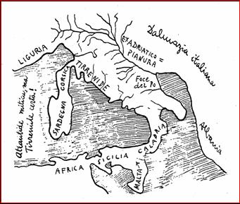 Tirrenide is the name given to a large landmass that was supposedly submerged off the west coast of Italy, which subsequently gave its name to the Tyrrhenian Sea. Some of these ideas were proposed in 1840 by Angelo Mazzoldi in Delle Origini Italiche who also placed Atlantis in this ancient Italy.
The name ‘Tirrenide’ was first proposed by C.J. Forsyth Major in 1882.
The idea of the existence of such a large sunken land is seemingly supported by Pliny the Elder in Natural History (III, Of Italy) where he compared the shape of Italy to an oak leaf: “I may premise by observing that this land very much resembles in shape an oak leaf, being much longer than it is broad…” which seems a far cry from the boot-like shape used to describe Italy today.
Some commentators, such as Pier Paolo Cavallin(e) [1049] and Evelino Leonardi, have tried to link the story with Atlantis. Leonardi’s contribution to the belief that there was an Italian Atlantis is explored in depth by Marco Pucciarni(d). Von Klaproth speculated that it had been a vast island that filled most of the Western Mediterranean. Others suggest the vicinity of Calabria or part of a landbridge between Italy and North Africa.
The legend of Tirrenide is frequently linked with the island of Sardinia (along with Corsica). This is the view of Leonardo Melis who considers his Tirrenide to have been a rival empire of Atlantis(c).
Constantino Cattoi expressed some odd views involving an extension of Atlantis reaching into the Mediterranean as far as Italy and added that just offshore from Ansedonia, 70 miles north of Rome may have been the location of the Atlantean capital! This concept has now been adopted by Francesco Palambo.
Cattoi also announced that he had located three of the cities of Tirrenide between Porto Santo Stefano and Isola del Giglio, but he died without being able to find funding for the underwater exploration that would have proved his hypothesis(b).
A more recent view of Tirrenide at the end of the last Ice Age is available online(a).
(a) http://web.archive.org/web/20191216233451/https://atlantipedia.ie/samples/archive-2510/
(b) https://www.paginecuriose.it/2019/07/28/atlantide-vicino-allargentario/ (Italian)
(c) La Sardegna e Atlantide (archive.org) (Italian)
(e) Pier Paolo Cavallin – Atlantisforschung.de (atlantisforschung-de.translate.goog)
Mortillet, Gabriel de
 Gabriel de Mortillet (1821-1898) was a French anthropologist, so it was probably inevitable that his interest in prehistory led to a comment on Atlantis, which he duly did in a paper in the reports of the Anthropological Society of Paris in 1897, in which he discussed Atlantis in the context of Atlantic landbridges. He totally discounted the Azores as the remains of an inhabited continent in the distant past. The original text[1338] as well as a rather poor English machine translation of de Mortillet’s paper is available online(a).
(a) http://web.archive.org/web/20191216233720/https://atlantipedia.ie/samples/document-191112/
Homet, Marcel F.
Marcel F. Homet (1897-1982) was a famous French Algerian scientist who published over twenty books  on anthropology, ethnology and ancient history generally. His most famous book is Sons of the Sun[813] in which he discussed his work in South America where he found evidence of Old World connections, in particular, on the famous Pedra Pintada (Painted Rock)(a) in Brazil, in a region that provides evidence of human activity there as early as 40,000 years ago. Although, because of the acidic soil the earliest human bones are dated to 12,000 years ago(b). Some of the Pedra Pintada images have been claimed to represent UFOs!
Just as mysterious is the Brazilian Ingá Stone with its astonishing collection of carved symbols. One researcher, Gabriele Baraldi, has interpreted the carvings as evidence of a Hittite presence in Brazil(f).
A 2023 article draws attention to another site in Brazil’s Mato Grosso State known as the Santa Elina rock shelter, where evidence of human activity has been dated to 25,000 years ago(e).
The title of Homet’s book is his name for Atlanteans. Homet believed that Atlantis had been located in the Atlantic and was part of a landbridge linking Europe and the Americas, an idea that was still popular when he was a child, but abandoned long since. Homet contended that refugees fleeing its destruction had escaped to both of those continents. He linked “tools, inscriptions, cults and monuments in both Crete and Egypt on the one hand with the Amazon regions on the other.”
A review of his book is available on the Atlantisforschung website(d).
The final chapter in Homet’s book is devoted to the Phaistos Disk, which he claims to be Atlantean. He continually points out aspects of the ideograms stamped on it which have counterparts in various pre-Columbian cultures. “The totality of the ideograms or symbols on the disc – they are all as familiar in the prehistoric Mediterranean countries as in Ancient America (although of older date there) – leads us inevitably to search for a common origin, which can only be found in the northern part of the space which lies between the two continents (Eurasia and America), in other words: Atlantis!” [p193]
Atlantisforschung lamented the fact that following his death and after a life gathering research material, most was lost or disappeared(c).
(a) http://web.archive.org/web/20191017002736/https://atlantipedia.ie/samples/archive-2218/
(b) BRASILE PREISTORICO (archive.org)
(c) Marcel F. Homet – Atlantisforschung.de (atlantisforschung-de.translate.goog)
(d) Marcel F. Homet, Atlantis and the Sons of the Sun – Atlantisforschung.de (atlantisforschung-de.translate.goog)
(f) https://brazilweirdnews.blogspot.com/2012/09/the-miystery-of-ingas-stone.html
Reid, Clement
 Clement Reid (1853-1916) was a British geologist and paleobiologist, whose great uncle was Michael Faraday. His studies in the North Sea led him to suggest the existence of a land bridge between Britain and mainland Europe that included the Dogger Bank. In 1913, he published Submerged Forests which included a speculative map of this land bridge that conforms closely to what we now call ‘Doggerland’, one of the many suggested sites for Atlantis, although Reid did not subscribe to this idea. His book can now be read online(a).

Reid’s Map of Dogger Bank
(a) https://www.archive.org/stream/submergedforests00reid#page/30/mode/2up
Festin, Carl
Carl Festin (1957- ) is a Swedish researcher who was prompted by questions from his children to investigate the history of civilisation. His studies led him to conclude that the hundreds of worldwide flood myths involved a catastrophe that involved the biblical story of Noah* and Plato’s  tale of Atlantis.
In a PowerPoint presentation provocatively entitled Noah, Refugee from Atlantis Festin outlines a new Atlantis theory. He first suggests that a ridge of sediment built up in the vicinity of Gibraltar, gradually cutting off the Mediterranean from the Atlantic when sea levels were much lower during the last Ice Age. This similar in some ways with the theory of Paulino Zamarro.
Festin posits an island in the Eastern Mediterranean, south of Crete, called Basileia, which dominated the land around what we now call the Ionian Sea. This nation was known as Atlantis.
He identifies the mountains of what is now Crete and Al Jabal Al Akhdar (Green Mountain) in Libya as the Pillars of Heracles. These are shown on a new map(b). Other maps(c) show his proposed Atlantean capital, Poseidopolis and are sometimes oriented east-west.
Around 3,500 BC, the Gibraltar ridge broke due to the pressure of the rising ocean levels following the melting of the ice. The influx of cold water into the Western Mediterranean Basin created extensive anti-cyclonic rainfall over Basileia (40 days and nights!). The Western and Eastern Mediterranean Basins were separated by a landbridge at the Strait of Sicily, which is now broken, inundating the eastern basin. Festin claims that the millions of tons of additional 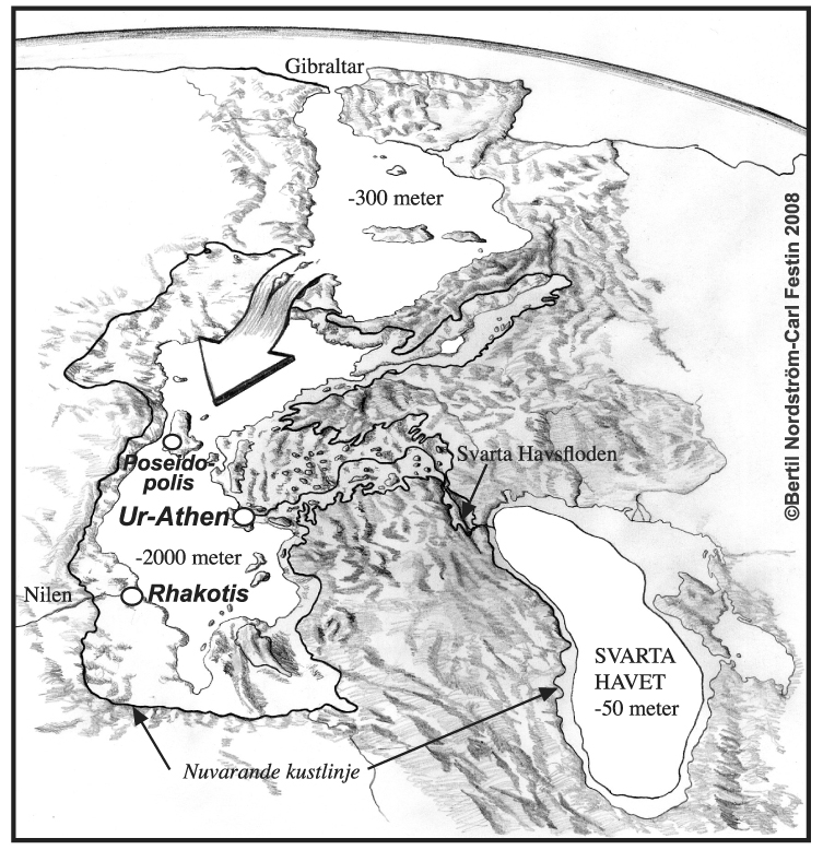 water created earthquakes in seismically fragile central Mediterranean, destroying Basileia. Survivors included Noah, who headed eastward. Others reached both North and South America.
Festin is now organising a five day cruise in the Mediterranean, which will include a dive in a small submersible to the Atlantean capital Poseidopolis on the submerged island of Basileia lying between Crete and Cyrenaica in Libya. The adventure can be watched on board the ship on large screens, while for the really enthusiastic, there are 8/10 spaces available in the submarine. He currently estimates the basic cost to be €2,000 and €100,000 for each of the 8/10 submariners(d). I think comment is unnecessary!
His theories are published in Swedish as Flykting från Atlantis[753] (Refugees from Atlantis)(a).
(b) http://www.resmalet.se/Atlantis.htm
Strait of Gibraltar
The Strait of Gibraltar according to Greek mythology was created by Herakles. Neville Chipulina explains that “it seems that the person responsible for the myths about Hercules was Peisander of Rhodes, a 7th century BC Greek epic poet who apparently got the story from an unknown Pisinus of Lindus who almost certainly plagiarised it from somebody else. In other words, it’s a pretty old story.”(c)
The Strait is very much a part of many current Atlantis theories. Primarily, it is contended that the region itself held the location of Atlantis. This is based on Plato’s statement that Eumelos, also known as Gadeirus, the twin brother of Atlas the first king of Atlantis gave his name to Gades, known today as Cadiz. Andalusia in Southern Spain has been the focus of attention for over a hundred years. In recent years Georgeos Diaz-Montexano and his rival Jacques Colina- Girard have been investigating the waters of the Strait itself while south of the Strait Jonas Bergman has advanced his theory that Atlantis was located just across the Strait in Morocco.
Although there is general acceptance that the Pillars of Heracles had their final resting place in the vicinity of the Strait of Gibraltar, it must be noted that there have been other candidates at different times with equally valid claims. The location of the ‘Pillars’ referred to by Plato at the time of Atlantis is the subject of continuing debate.
Archaeologist Josho Brouwers has noted that(g) “according to Strabo (3.5.5), Hercules raised the Pillars during one of his Twelve Labours to mark the western edge of the inhabited world. One pillar was identified as the Rock of Gibraltar (called Mount Calpe in ancient times), with the other was Ceuta (Mount Abile) on the African side of the narrow strait.
Diodorus Siculus mentions that Hercules put the Pillars in place as a monument to himself (4.18.4). He also adds that Hercules either narrowed the passage in order to prevent sea-monsters from the Atlantic to enter the Mediterranean, or to actually open the mountain so that the Atlantic could mingle with the Mediterranean. On this issue, as Diodorus puts it, “it will be possible for every man to think as he may please” (4.18.5).” For me it raises a warning flag regarding the hasty acceptance of ancient myths and traditions as having an historical basis.
Strato, the philosopher, quoted by Strabo, spoke of a dam separating the Atlantic and the Mediterranean being breached by a cataclysm. This idea was reinforced by comments of Seneca. Furthermore, a number of Arabic writers, including Al-Mas’udi, Al-Biruni and Al-Idrisi, have all concurred with this idea of a Gibraltar land bridge in late prehistory.
A more radical theory is that of Paulino Zamarro who contends that the Strait was in fact closed by a landbridge during the last Ice Age because of the lower sea levels together with silting. When the waters rose and breached the landbridge, he believes that the flood submerged Atlantis, which he situates in the Aegean. Others support Zamarro’s idea of a Gibraltar Dam amongst whom are Constantin Benetatos and Joseph S. Ellul.
Terry Westerman on his heavily illustrated website surveys impact craters globally. He suggests that “The Strait of Gibraltar was formed by two meteor impacts. The first blasted the round area in the western Mediterranean Sea to form a land bridge between Spain and Morocco.” He maintains that a second impact broke the landbridge around 5.33 million years ago, creating what is called the Zanclean Flood which refilled the then desiccated Mediterranean(d).
A German-language website(a) presented some of the following data+, apparently recording the dramatic widening of the Strait of Gibraltar between 400 BC and 400 AD. The same list was included in the ‘Strait of Gibraltar’ entry of the German Wikipedia(b) until a few years ago. It has since been removed.
Alexander Braghine offered [156.139] similar data*, which, unfortunately, is also unreferenced.
+Damastes of Sigeum, circa 400 BC. – about 1.3 km
+Pseudo-Skylax, probably fourth Century BC – about 1.3 km
*Turiano Greslio? 300BC – 8.0 km
*+Titus Livius (Livy) 59 BC- 17 AD – 10.5 km
+Strabo 63 BC- 24 AD – from 9.5 to 13.0 km
+Pomponius Mela , 50 AD – about the 15.0 km
+Pliny the Elder, 50 AD – about 15.0 km
*+Victor Vicensa (*Vitensa?), 400 AD – about 18 km
Procopius, 550 AD – about 15.0 km
The above figures suggest that in the latter half of the first millennium BC, the Strait of Gibraltar was gradually widened. However, the figures given suggest that between 400 and 550 AD the Straits narrowed again seems absurd. Nevertheless, until the methods used and all the data on offer have been verified, the idea must be treated with great caution.
My list had originally included Euctemon, the 5th century BC Athenian astronomer, however, Werner E. Friedrich notes that Euctemon was referring to the Sea of Marmara near the entrance to the Black Sea [0695.38].
However, more recently, John Jensen Jnr. has offered a comparable, if shorter, number of dates showing the reducing width of the strait the further back you go, from which he extrapolated that around 3450 YBP when he believes that a landbridge there was breached(e).
Jensen’s estimated widths for the strait are without references, but suggest a similar story of a gradually widening entrance to the Mediterranean.
1,100 BC 2 Miles (3.2 km}
480 BC 4 Miles (6.5 km
60 BC 7 Miles (11.2 km)
1200 AD 12 Miles (19.3 km)
Now 15 Miles (24 km)
Georgeos Diaz-Montexano has also referred to the descriptions by ancient writers of the Strait of Gibraltar indicating a width of around two kilometres. Unfortunately, he does not cite references(f). He is also sympathetic to the existence of an earlier landbridge at Gibraltar.
(a) https://de.academic.ru/dic.nsf/dewiki/1337738
(b) https://de.wikipedia.org/w/index.php?title=Stra%C3%9Fe_von_Gibraltar&oldid=60093153
(c) https://gibraltar-intro.blogspot.ie/2015/10/bc-pillars-of-hercules-if-ordinary.html
(d) The Formation of the Strait of Gibraltar (archive.org)
(e) https://www.migration-diffusion.info/article.php?id=514 and https://www.linkedin.com/pulse/earths-axis-tilt-john-jensen-jr-
(f) https://web.archive.org/web/20200630064033/http://freerepublic.com/focus/f-news/1011563/posts
(g) The Pillars of Hercules – Ancient World Magazine