Latest News

Joining The Dots
I have now published my new book, Joining The Dots, which offers a fresh look at the Atlantis mystery. I have addressed the critical questions of when, where and who, using Plato’s own words, tempered with some critical thinking and a modicum of common sense.Read More »
Erytheia
Bosporus, The
?The Bosporus or Bosphorus is described by Wikipedia as “a narrow, natural strait and an internationally significant waterway located in northwestern Turkey. It forms part of the continental boundary between Asia and Europe, and divides  Turkey by separating Anatolia from Thrace. It is the world’s narrowest strait used for international navigation. The Bosporus connects the Black Sea with the Sea of Marmara, and, by extension via the Dardanelles, the Aegean and Mediterranean seas, and by the Kerch Strait, the Sea of Azov.”
A number of modern commentators have promoted the Bosporus as the location of the Pillars of Herakles; Eberhard Zangger, Christian and Siegfried Schoppe and Werner E. Friedrich.
Arysio dos Santos in his book Atlantis [320.186] noted that “The Bosphorus was considered to be the site of the ‘Pillars of Hercules’ even before the name of these famous features was transplanted to the region of Gibraltar, where it remains stuck down to the present time. In reality, bosporus or bosphorus (or bosporos or bosphoros, rather, the Greek words from which the Latin name derives) means ‘cattle passage, oxford’ precisely because Hercules was said to have crossed there with the cattle he rustled from Geryon, in Erytheia.”
Odysseus & Herakles
Odysseus and Herakles are two of the best-known heroes in Greek mythology, both of whom had one important common experience, they each had to endure a series of twelve tests. However, although different versions of the narratives are to be found with understandable variations in detail, the two stories remain substantially the same.
The two tales have been generally interpreted geographically although a minority view is that an astronomical/astrological interpretation was intended, as the use of twelve events in both accounts would seem to point to a connection with the zodiac!
Alice A. Bailey is probably the best known regarding Hercules in her book The Labours of Hercules[1163], while Kenneth & Florence Wood have also proposed Homer’s work as a repository of astronomical data[0391]. Bailey’s work is available as a pdf file(d).
In geographical terms, Herakles and Odysseus share something rather intriguing. Nearly all of the ‘labours’ of Herakles (Peisander c 640 BC) and all of the ‘trials’ of Odysseus (Homer c.850 BC) are generally accepted to have taken place in the eastern Mediterranean. In fact, the first map of the geography of the Odyssey was produced by Ortelius in 1597, which situated all of the locations in the central and eastern Mediterranean(e).
However, in both accounts, there is a suggestion that they experienced at least one of their adventures in the extreme western Mediterranean, at what many consider to be the (only) location of the Pillars of Heracles as defined by Eratosthenes centuries later (c.200 BC). Significantly, nothing happens over the 1100-mile (1750 km) journey on the way there and nothing occurs on the way back!
I think it odd that both share this same single, apparently anomalous location. I suggest that we should consider the possibility that the accounts of Heracles and Odysseus are possibly distorted versions of each other and that, in the later accounts of their exploits, the use of the extreme western location for the trial/labour is possibly only manifestation of a blind acceptance of the geographical claims of Eratosthenes or a biased view that this was always the case. A credible geographical revision of the location of those inconsistent activities by Odysseus and Heracles to somewhere other than the Gibraltar region would add weight to those, such as myself, that consider a Central Mediterranean location for the ‘Pillars’ more likely.
Philipp Clüver spent some years surveying Italy and Sicily and concluded in his Sicilia Antiqua (1619) that the Homeric locations associated with the travels of Odysseus were to be found in Italy and Sicily(g) and that Homer identified Calypso’s Island (Ogygia) as Malta.
The University of Buffalo website offers a number of maps associated with a variety of theories relating to elements found in Homer’s epic poems(i).
The German historian, Armin Wolf, relates how his research over 40 years unearthed 80 theories on the geography of the Odyssey, of which around 30 were accompanied by maps. In 2009, he published, Homers Reise: Auf den Spuren des Odysseus[0669], a German language book that expands on the subject, concluding that all the wandering of Odysseus took place in the central and eastern Mediterranean. In a fascinating paper(a) he reviews many of these theories and offers his own conclusion on the subject, along with his own proposed maps, which exclude the western Mediterranean entirely. Wolfgang Geisthövel adopted Wolf’s conclusions in Homer’s Mediterranean [1578].
With regard to Hercules, the anomalous nature of the ‘traditional’ location of Erytheia for his 10th ‘labour’ is evident on a map(b), while the 11th could be anywhere in North Africa.
Further study of the two narratives might offer further strong evidence for a central Mediterranean location for the ‘Pillars’ around the time of Solon! For example, “map mistress” places Erytheia in the vicinity of Sicily(c), while my personal choice would be the Egadi Islands further to the north, Egadi being a cognate of Gades, frequently linked with Erytheia.
There is also a school of thought which suggests that most of Odysseus’ wanderings took place in the Black Sea. Anatoliy Zolotukhin is a leading exponent of this idea(f).
Wikipedia touched on the even more controversial suggestion that Odysseus had travelled in the Atlantic – “Strabo‘s opinion that Calypso’s island and Scheria were imagined by the poet as being ‘in the Atlantic Ocean’ has had significant influence on modern theorists. Henriette Mertz, a 20th-century author, argued that Circe’s island is Madeira, Calypso’s island one of the Azores, and the intervening travels record a discovery of North America: Scylla and Charybdis are in the Bay of Fundy, Scheria in the Caribbean.” (h)
(b) https://www.igreekmythology.com/Hercules-map-of-labors.html
(c) Pantelleria & Erytheia: Southwest Sicily Sunken Coastline to Tunisia (archive.org)
(d) https://www.bailey.it/files/Labours-of-Hercules.pdf
(e) https://www.laphamsquarterly.org/roundtable/geography-odyssey
(f) https://homerandatlantis.com/wp-content/uploads/2016/08/Scylla-CharybdisJAH-1.pdf
(g) https://journals.openedition.org/etudesanciennes/906
(h) Geography of the Odyssey – Wikipedia *
(i) INDICES (buffalo.edu) *
Erytheia
Erytheia, sometimes known as the ‘Red Isle’, is recorded by Hesiod (8th cent. BC) as one of the three Hesperides, a sunken island beyond the Pillars of Heracles. Pherecydes of Athens (5th cent. BC), is considered to be the first to identify Erytheia with Gádeira (Cadiz) according to Strabo (Geog. Bk. III). Some commentators have found many of its characteristics comparable with those of Plato’s Atlantis. Herodotus (Hist. 4.8) also describes it as an island that was located beyond the ‘Pillars’ near Gades. Avienus also supported this idea, while Solinus described it as being on the Lusitanian coast (Portugal).
N. Zhirov agreed with Adolf Schulten in identifying Erytheia with Tartessos. However, while Schulten located Tartessos at the mouth of the Guadalquivir River in South West Spain, Zhirov argued that the story of Hercules taking from Erytheia, the oxen of Geryon, indicated a distance of around 60 miles from the coast. He points out that since Hercules had to get from Helios the ‘golden cup’ in order to show direction by day and night, it would not have required a compass had the island been close to land. Similarly, he reasoned that Erytheia could not have been more than one or two days journey since their small boat could not have carried enough food and water for the animals on a long journey.
Isla de León is a large piece of land between the city of Cádiz and the mainland and is accepted by some as having been the home of the mythical giant Geryon and his cattle. Rhys Carpenter identified Isla de León as Erytheia. [221]
Controversially, Gades(a) and Erytheia(b) have both been placed on the Map Mistress website in the Central Mediterranean and since they have both been associated with the ‘Pillars of Heracles’, is she suggesting a location in that region for Atlantis?
A paper on the subject was presented to the 2005 Atlantis conference on Melos, by Papamarinopoulos, N. Drivaliari & Ch. Coseyan, who also place Erytheia in the vicinity of Cadiz.[629.540]
Pamina Fernandez Camacho, a Spanish philologist, offers a detailed study(c) of Erytheia in which she concludes that it is “a mythical name attributed to a real place, Gádeira, modern Cadiz.(c)
(a) http://www.mapmistress.com/egadi-islands-marettimo-levanzo-favignana.html (link broke Dec 2020) Text only available at Egadi Islands: Marettimo, Levanzo, Favignana of Sicily (archive.org)
(b) http://www.mapmistress.com/pantelleria-erytheia-sicily-tunisia.html (link broke Dec 2020) Text only available at Pantelleria & Erytheia: Southwest Sicily Sunken Coastline to Tunisia (archive.org)
(c) https://web.archive.org/web/20240620192649/https://core.ac.uk/download/pdf/328024772.pdf
Pantelleria
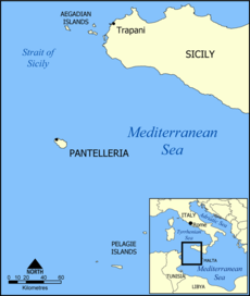 Pantelleria was formed by ancient volcanic action, but even as recently as 1891, there was a submarine eruption off its NW coast(j). This ancient vulcanism created large deposits of highly-prized obsidian on the island. Because of its importance for tool making, it was traded extensively in the Central Mediterranean from the Neolithic period onwards(g).
The island, formerly known as Cossyra, is an Italian-controlled island between Sicily and Tunisia. One suggestion, from Andis Kaulins has been that it was the original Gaderia(a).
This conclusion is probably based on the existence of a location on the northeast coast of the island called Gadir. However, it must be kept in mind that Gadira or variants of it are frequently found in the Mediterranean region, usually at the site of former Phoenician settlements. However, north of Pantelleria is the Egadi Islands(c), another name evocative of Plato’s Gades.
Gades has been associated with Erytheia in the story of the Trials of Hercules, so if the Map Mistress website is correct in locating Erytheia(d) between Pantelleria and the Egadi Islands, it would confine all the ‘Trials’ in the Central and Eastern Mediterranean, consequently, locating the Pillars of Heracles somewhere in the latter region.
More recently, some authors have identified the Straits of Sicily as being the location of the Pillars of Heracles referred to by Plato in his tale of Atlantis. A land bridge between Sicily and Tunisia, including Pantelleria, has also been suggested, but this is considered unlikely according to bathymetric data.
Novelist Samuel Butler (1835-1902) identified Pantelleria as Calypso’s Island, but the idea received little support(i).
A fortified Neolithic village has been unearthed on its west coast and ancient structures, known as ‘sesi’, similar to the nuraghi of Sardinia, are to be seen in the southeast. One in particular, known as the Grande Sese, is a 5,000-year-old six-metre high mausoleum, containing twelve ‘cells’. “The civilization who built this and another sese nearby are believed to have settled on the island after arriving from Northern Africa.”(h)
In 2005, jewellery in the style of the Egyptian Second Intermediate Period (1700-1550 BC) was discovered on the island. This would add to the opinion that Pantelleria was a major trading and cultural crossroads in ancient times.
Massimo Rapisarda has commented that “a good candidate to host a primordial civilization might have been the archipelago then existing in the Strait of Sicily, a natural maritime link between Tunisia and Italy, prized by the presence of an obsidian source at Pantelleria.”(f)
In August 2015, it was claimed(b) that a manufactured stone column was found on the Pantelleria Vecchia Bank, just north of the island of Pantelleria, in 40 metres of water. It is claimed that the area was formerly the site of an archipelago, if not actually connected to Sicily, before the last Ice Age ended around 7350 BC. The monolith was dated using shells extracted from it. It took no time before the discovery was linked by a number of sites with Plato’s Atlantis. While I believe that the area was part of the Atlantean domain, I am more inclined to date its expansionist intentions to a much later period, such as the 2nd millennium BC.
(a) https://web.archive.org/web/20200130221548/http://www.lexiline.com/lexiline/lexi60.htm
(c) https://web.archive.org/web/20180627052748/http://www.mapmistress.com/egadi-islands-marettimo-levanzo-favignana.html (text only)
(d) https://web.archive.org/web/20180831115550/http://www.mapmistress.com/pantelleria-erytheia-sicily-tunisia.html (text only)
(e) Stone Pages Archaeo News: Ancient Egypt gems on Italian isle (archive.org)
(g) https://www.academia.edu/33910010/Characterization_of_obsidian_sources_in_Pantelleria_Italy
Egadi Islands
The Egadi Islands are located off the west coast of Sicily and were the location for a naval battle in 241 BC that resulted in the defeat of the Carthaginians by the Romans which brought an end to the First Punic War.
At the height of the last Ice Age, the islands were connected by a landbridge to the Sicilian mainland, because of the lower sea level(c). They have been suggested by Andis Kaulins(a) as the location of the kingdom of Gadirus, who was the twin brother of Atlas, the first king of Atlantis. Until recently, it was generally accepted that the 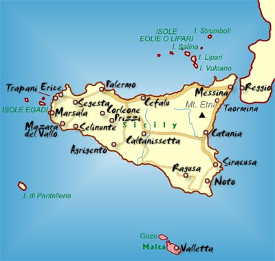 realm of Gadirus had been situated in the vicinity of modern Cadiz, known in ancient times as Gades. This idea was enhanced by its proximity to the Strait of Gibraltar, deemed by many to be the site of the Pillars of Heracles.
However, there has been growing support for the idea of the Pillars, referred to by Solon/Plato, being situated in the Central Mediterranean, at either the Strait of Messina or the Strait of Sicily, the latter supported by Andis Kaulins, who goes further and suggests a link between Tartessos and ancient Carthage across the Strait in Tunisia.
More recently, Albert Nikas has argued cogently(b) for placing the Pillars of Heracles in the vicinity of the Egadi Islands and identifying them with Plato’s Gades and then concluded that Malta had been ‘the island in front of the Pillars’ and was Atlantis.
>Ernle Bradford made one passing reference to Atlantis in Ulysses Found [1011.57] which may be of interest to supporters of a Central Mediterranean Atlantis. When discussing the Egadi Islands off the west coast of Sicily he describes Levanzo, the smallest of the group as being “once joined to Sicily, and the island was surrounded by a large fertile plain. Levanzo, in fact, was joined to more than Sicily. Between this western corner of the Sicilian coast and the Cape Bon peninsula in Tunisia there once lay rich and fertile valleys-perhaps, who knows, long lost Atlantis?” This would seem to be close to the views of Alberto Arecchi and others.<
If the name of the Egadi Islands is more than just evocative of Plato’s Gades and since Gades has also been associated with Erytheia in the story of the ‘Trials of Hercules’, then if Izabol Apulia’s Map Mistress website is correct in locating Erytheia(d) between Pantelleria and the Egadi Islands it would confine all the ‘Trials’ in the Central and Eastern Mediterranean, consequently, locating the Pillars of Heracles somewhere in that region.
Opposite the Egadi Islands on the mainland of Sicily is the port of Marsala(e), which has also been identified, by Massimo Rapisarda, as another possible location for Atlantis.
(a) Pillars of Heracles – Alternative Location (archive.org)
(b) http://atlantisonline.smfforfree2.com/index.php/topic,20615.0.html
(c) http://www.sci-news.com/archaeology/article00749.html
(d) Pantelleria & Erytheia: Southwest Sicily Sunken Coastline to Tunisia (archive.org)