Argentina
Fisher, Doug
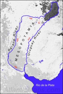
 Doug Fisher is the author of a long-awaited book with the intended title of The Atlantis Maps: The Rise of Atlantis and the Fall of a Paradigm in which he identifies Atlantis as North and South America with the Plain described by Plato being the region of Mesopotamia, in northeast Argentina. The book was eventually published in 2018 as Maps, Myths and Paradigms [1924] with details of its contents listed on his website.(c) Four chapters had been available online(a) together with a few additional articles.
Fisher has published an illustrated paper on Graham Hancock’s website with the self-explanatory title of The Walls of Atlantis(b). His suggestion of a huge outer wall encircling the city of Atlantis has been disputed by Jim Allen, provoking further comments(c) from Fisher.
He has also criticised the methodology, which Allen used to place Atlantis on the Altiplano(d), while I question the credibility of both their theories.
When Fisher’s book was finished and due for publication with its new title, he closed his old website and prepared a new site(e) to coincide with the publication of the book.
Fisher has published two other papers(f) on Hancock’s website relating to the maps of Johannes Schöner and Oronteus Finaeus.>In October 2022 he published another paper on the same site challenging the currently accepted theory of plate tectonics highlighting weaknesses in the concept and proposing a fresh look at the expanding earth hypothesis.<
(a) See: Archive 2865 (no images)
(b) https://grahamhancock.com/fisherd3/
(c) http://www.abovetopsecret.com/forum/thread646457/pg2 (halfway down the page)
(d) http://www.abovetopsecret.com/forum/thread821281/pg1
(e) http://www.copheetheory.com/
(f) https://grahamhancock.com/author/doug-fisher/
(g) Maps, Myths & Paradigms – Graham Hancock Official Website *
Finaeus, Oronteus
Oronteus Finaeus (1494-1555) was a celebrated cartographer who produced a map in 1531 which is claimed by some that, like the Piri Reis  Map, it depicts the coast of an ice-free Antarctica. Charles Hapgood rediscovered it in 1959(a) in the Library of Congress. This idea is then used to support the concept of the existence of a very early civilisation that was capable of sophisticated map-making. It is then just a short step to name this civilisation ‘Atlantis’. Some, such as the Flem-Aths went further and actually nominated Antarctica as the home of Atlantis.
Robert Argod has used the Oronteus Finaeus Map to support his contention that the Polynesians had originated in Antarctica.
>Christine Pellech has an article published on the Atlantisforschung website taken from her 2013 book Die Entdeckung von Amerika [1188] (The Discovery of America), in which she reviews the range of medieval maps displaying geographical details ‘unknown’ until centuries later!(e) Her reference to the Mark McMenamin coins can be ignored as they have since been shown to be forgeries (See: Sardinia).<
However, a contrary view has been expressed by Paul Heinrich who commenting on Graham Hancock’s assertion that the map shows an ice-free Antarctica, points out that in the case of West Antarctica, the underlying bedrock is, in the main, hundreds of feet below sea level and would not show on a real map of the region(c).
A more recent website(b), although not endorsing an Antarctic Atlantis, discusses some of these old maps in very great detail and on Graham Hancock’s website. The site is based on a number of chapters from a work-in-progress, The Atlantis Maps: The Rise of Atlantis and the Fall of a Paradigm by Doug Fisher. He identifies the Plain of Mesopotamia in Northern Argentina as the location of Atlantis.
(a) https://archive.aramcoworld.com/issue/198001/piri.reis.and.the.hapgood.hypotheses.htm
(b) https://web.archive.org/web/20180831132132/https://www.atlantismaps.com/ ^30.10.2020 “This URL has been excluded from the Wayback Machine.”
(c) https://atlantipedia.ie/samples/archive-3967/
Argentina
 Argentina is one of the latest locations to be proposed for Atlantis. Doug Fisher has a work-in-progress entitled The Atlantis Maps: The Rise of Atlantis and the Fall of a Paradigm. On his website(a) Fisher offers four chapters from his forthcoming book. The first three chapters on offer discuss in great detail the 16th century maps that are claimed to show an ice-free Antarctica. In the final chapter he argues that Plato’s text could only have been referring to the Americas as the location of Atlantis. He goes further and specifies the Plain of Mesopotamia in northern Argentina as the plain described by Plato with a landform in the Paraná Delta conforming to the dimensions he gave for the circular city of Atlantis.
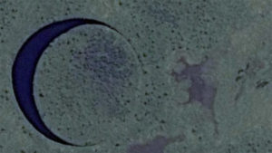
Completely unrelated to Atlantis but perhaps even more intriguing is a circular feature in the  Paraná Delta know as ‘El Ojo’ (The Eye) which has only recently been discovered. It is a perfectly circular ‘lake’ 120 metres across with a floating ‘island’ in it which is also perfectly circular. There is an English language video(b) clip outlining the extent of the mystery and the plans to mount a multidisciplinary expedition to study it further.
>(a) See: https://web.archive.org/web/20180831132132/https://www.atlantismaps.com/ ^30.10.2020 “This URL has been excluded from the Wayback Machine.”<
Plain of Atlantis
The Plain of Atlantis is one of the principal features recorded by Plato in great detail. He describes it being “3000 stades in length and at its midpoint 2000 stades in breath from the coast” (Critias 118a, trans. Lee). The shape of the plain is frequently given as ‘rectangular’ or ‘oblong’ and contained an efficient irrigation system that was fed by mountain streams. The fertility of the plain gave the inhabitants two crops annually.
The dimensions given by Plato would translate into 370 x 555 km (230 x 345 miles). However, the late Ulf Richter has recently proposed(a) that the dimensions originally given to Solon by the priests of Sais used the Egyptian ‘khet’ (52.4 meters) as the unit of measurement. Possibly Solon recorded the figures without mentioning the units employed. In Ireland, we changed over to the metric system some years ago, but builders still speak and write of using ‘2×4’ lengths of timber without specifying that they are referring to inches. Such unqualified notations made at present could be interpreted in the future as 2×4 centimetres. This illustrates how reasonable Richter’s suggestion is. The acceptance of it would give us a more credible 105 x 157 km (65 x 97 miles) as the dimensions of this plain. Richter also maintains that the plain was in fact a river delta, which explains the remarkable fertility of the land.
Rich McQuillen has adopted Richter’s suggestion that there was some unspecified translation confusion regarding the use of the Egyptian ‘khet’ or the Greek ‘stade’ by Solon. The revised dimensions led McQuillen to propose territory adjacent to Canopus at the mouth of the Nile as the location of the Plain of Atlantis. Canopus along with nearby Pharos and Herakleoin were destroyed by liquefaction resulting from an earthquake. McQuillen’s ideas also coincide with Richter’s additional proposal that Atlantis was situated on a river delta(a)*.
Galanopoulos and Bacon commenting [263.36] on the plain described in Critias 118a-e concluded that Plato had been referring to a second plain, “Next, the plain surrounding the city does not appear to be the same as the one close to the Ancient Metropolis since this lay in the centre of the island at a distance of 50 stades (6 miles) from the sea. Whereas the plain surrounding the City was 3,000 stades (340 miles) and 2,000 stades (227 miles) wide; and so the centre of this plain must have been very much more than six miles from the sea. The attempt to reconcile these statements by suggesting that the Ancient Metropolis was not in the centre of the island but close to the sea in the middle of one of the sides of the island likewise will not work in view of the passage (Critias 113d) which states that the belts of water encircling the metropolis were everywhere equidistant from the centre of the island.”
Jim Allen, who supports an Andean location for Atlantis, offers a strong argument against other principal Atlantis candidates by critically examining the plains included in alternative location theories(c). However, it must be pointed out that Allen had to divide Plato’s dimensions for the plain by two in order to shoehorn it into his chosen location.
While I accept that there is evidence that there was flooding on the Altiplano, it took place some thousands of years before the Bronze Age Atlantis described by Plato and certainly long before he wrote “this is why the sea in that area is to this day impassible to navigation, which is hindered by mud just below the surface, the remains of the sunken island.” (Timaeus 25d – Desmond Lee) This is not a description that can be applied to anywhere on the Altiplano during the 1st millennium BC. Apart from that, Plato’s account clearly states that Atlantis was submerged and was still so in his own day, making Allen’s critique somewhat redundant.
An interesting suggestion, although badly flawed, was made by Jean Deruelle who proposed ‘Doggerland‘ in the North Sea as the location of Atlantis, adding an interesting twist to Plato’s description of the Plain. “Deruelle, an engineer and a geologist by profession, offers a hypothesis that is rational, highly precise, and based on his areas of expertise. No other hypothesis than Deruelle’s tackles so credibly the most outlandish elements in Plato’s description of Atlantis: the description of a vast plain, surrounded by a man-made ditch, 180 meters broad and thirty meters deep, large enough to circulate supertankers: it was not a ditch, but a dyke, build over centuries to protect a large part of Doggerland against the slowly rising waters of the North Sea.”(d)
Diaz-Montexano maintains that Plato never said that the plain was shaped like a rectangle.
The Mediterranean, between Sicily and North Africa, has been offered by a number of commentators, such as Alberto Arecchi and Alex Hausmann, as the location of the Plain of Atlantis. There is evidence of large areas of land having been submerged within the region between Malta and the Pelagie Islands. I include here a passing reference from Ernle Bradford who sailed the region which may be of interest to supporters of a Central Mediterranean Atlantis. When discussing the Egadi Islands off the west coast of Sicily he describes Levanzo, the smallest of the group as being “once joined to Sicily, and the island was surrounded by a large fertile plain. Levanzo, in fact, was joined to more than Sicily. Between this western corner of the Sicilian coast and the Cape Bon peninsula in Tunisia there once lay rich and fertile valleys-perhaps, who knows, long lost Atlantis?” [1011.57]
The number of different locations that have been proposed for the plain is obviously a reflection of the number of sites suggested for the city of Atlantis. I list the most popular below with the added comment that, at best, only one can be correct while all may be wrong.
Plain of Atlantis
Mauritania (David Edward)
Mesara Plain on Crete (Braymer)
Central Plain of Ireland (Erlingsson)
Sea of Azov (Flying Eagle & Whispering Wind)
Altiplano of Bolivia (Jim Allen)
Andalusian Plain (Diaz-Montexano)
North Sea (Doggerland) (Jean Deruelle)
Plain of Catania, Sicily
Plain of Campidano, Sardinia (Giuseppe Mura)
Souss-Massa Plain, Morocco (Michael Hübner) (Mario Vivarez)
Greenland (Mario Dantas)
Beni, Bolivia (David Antelo)
Mesopotamia in Argentina (Doug Fisher)
Black Sea (Werner E. Friedrich) (George K. Weller)
Plain of Troy (J.D.Brady)
South of England (E.J. deMeester)
Carthage (Pallatino & Corbato)
Celtic Shelf (Dan Crisp)
Western Plain, Cuba (Andrew Collins)
Portugal (Peter Daughtrey)
Wales (Paul Dunbavin)
Florida (Dennis Brooks)
Atlantic Floor (Michael Jaye)
Baffin Bay, Greenland (Ian Fox)
Between Sicily and Malta (Axel Hausmann)
Pannonian Plain, Hungary+(Ticleanu, Constantin & Nicolescu)
Guadalete River Plain (Karl Jürgen Hepke)
Mouth of the Nile (Rich McQuillen) (Robert Graves) *
South China Sea Indonesia (Dhani Irwanto) (Bill Lauritzen)
Saudi Arabia (Stan Deyo)
Venezuelan Basin (Caribbean) Brad Yoon (P.P. Flambas)
Yucatan Peninsula (Mark Carlotto)(b)
(a) https://web.archive.org/web/20160326200714/https://www.atlantis-schoppe.de/richter.pdf *
(b) A Commentary on Plato’s “Myth” of Atlantis – Before Atlantis
(c) https://web.archive.org/web/20200707234820/http://www.atlantisbolivia.org/plaincomparison.htm
(d) https://www.q-mag.org/the-great-plain-of-atlantis-was-it-in-doggerland.html
Mesopotamia
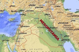
Mesopotamia was an area of the Middle East that corresponds to most of modern Iraq together with some surrounding areas.
>While Mesopotamia is widely known as the ‘cradle of civilisation’ there does seem to be a move to extend the regions to which this appellation can be justifiably applied. In a 2007 article in Science magazine, Andrew Lawler noted that “While Mesopotamia is still the cradle of civilization in the sense that urban evolution began there, we now know that the area between Mesopotamia and India spawned a host of cities and cultures between 3000 B.C.E. and 2000 B.C.E.” (f)<
It was first suggested by G.F. Oviedo y Valdes, in 1535, as the location of Atlantis. After its inundation, he claims that the survivors fled to the Americas.
 An article(c) by Marilyn Luongo also attempts to link Mesopotamia with Atlantis, beginning with locating the ‘Pillars of Heracles’ at the Strait of Hormuz and then using the highly controversial interpretation of ‘meizon’ to mean ‘between’ rather than ‘greater’, she proceeds to argue that Mesopotamia is ‘between’ Asia and Libya.>She cited Andreea Haktanir in support of this interpretation of meizon.<
Mesopotamia has recently been entered into the ‘Atlantis Stakes’ by Andreea Haktanir. Her website(a) has an extensive article that takes 14 chapters to conclude that Atlantis was Mesopotamia(e). Although I found her theory interesting, I was not convinced.
There is a website dedicated to the investigation of the development of civilisation, with particular reference to its manifestation through successive cultures who occupied Mesopotamia over millennia(b).
In July 2016 the most accurate timeline for the region was published following intensive research led by Cornell University archaeologist Sturt Manning(d). The data is now accurate back to the early second millennium BC and where estimates differed by up to 200 years, this has now been reduced to just 8 years.
Coincidentally, there is a region of Argentina called Mesopotamia that has also been identified as the original home of Atlantis.
(a) See: Archive 2562
(b) https://aratta.wordpress.com/
(c) https://web.archive.org/web/20200220020342/http://www.middle-east.mavericsa.co.za/history.html
(e) https://web.archive.org/web/20151229155837/https://atlantis.haktanir.org/ch14.html
(f) https://www.eurekalert.org/news-releases/461111 *
