Latest News

Joining The Dots
I have now published my new book, Joining The Dots, which offers a fresh look at the Atlantis mystery. I have addressed the critical questions of when, where and who, using Plato’s own words, tempered with some critical thinking and a modicum of common sense.Read More »
Egadi Islands
Italy
Italy seems to have an uncertain etymology; Thucydides claims that Italos, the Sicilian king gave his name to Italy, while more recently Emilio Spedicato(h) considers that ”the best derivation we believe to be the one proposed by the Italian nuclear engineer Felice Vinci (1998), in his monograph claiming a Baltic setting for the Homeric epic: he derives Italia from the rare Greek word aithalia, meaning the smoking one.” This is thought to be a reference to Italy’s many volcanoes.
Italy today is comprised of territory south of the Alps on mainland Europe including a very large boot-shaped peninsula, plus Sicily, Sardinia and some smaller island groups, which along with the French island of Corsica virtually enclose the Tyrrhenian Sea.
The earliest proposal that Italy could be linked with Atlantis came from Angelo Mazzoldi in 1840, when he claimed that before Etruria, Italy had been home to Atlantis and dated its demise to 1986 BC. Mazzoldi expressed a form of hyperdiffusion that had his Italian Atlantis as the mother culture which seeded the great civilisations of the eastern Mediterranean region(b).
Some of Mazzoldi’s views regarding ancient Italy were expanded on by later scholars such as Camillo Ravioli, Ciro Nispi-Landi, Evelino Leonardi, Costantine Cattoi, Guido DiNardo and Giuseppe Brex. Ravioli sought to associate the Maltese island of Gozo with his proposed Atlantis in Italy.
The Italian region of Lazio, which includes Rome, has had a number of very ancient structures proposed as Atlantean; Monte Circeo (Leonardi) and Arpino(a) (Cassaro). Another aspect of Italian prehistory is the story of Tirrenide, which was described as a westward extension of the Italian landmass into the Tyrrhenian Sea during the last Ice Age, with a land bridge to a conjoined Sardinia and Corsica. At the same time, there were land links to Sicily and Malta, which were all destroyed as deglaciation took place and sea levels rose.
 It is surprising that so few researchers have commented on Italy’s part in Plato’s Atlantis narrative considering that he twice, without any ambiguity, informs us that the Atlantean domain extended as far as Tyrrhenia (modern Tuscany).
Crit.114c. So all these, themselves and their descendants dwelt for many generations bearing rule over many other islands throughout the sea and holding sway besides, as was previously stated, over the Mediterranean peoples as far as Egypt and Tuscany. Tim.25a/b. Now in this island of Atlantis there existed a confederation of kings, of great and marvellous power, which held sway over all the island, and over many other islands also and parts of the continent; and, moreover, of the lands here within the Straits they ruled over Libya as far as Egypt, and over Europe as far as Tuscany. (Bury)
The quotation from Timaeus is most interesting because of its reference to a ‘continent’. Some have understandably but incorrectly claimed that this is a reference to America or Antarctica, when quite clearly it refers to southern Italy as part of the continent of Europe. Moreover, Herodotus is quite clear (4.42) that the ancient Greeks knew of only three continents, Europe, Asia and Libya.
Philo of Alexandria (20 BC-50 AD) in his On the Eternity of the World(g) wrote “Are you ignorant of the celebrated account which is given of that most sacred Sicilian strait, which in old times joined Sicily to the continent of Italy?” (v.139). The name ‘Italy’ was normally used until the third century BC to describe just the southern part of the peninsula(e). Some commentators think that Philo was quoting Theophrastus, Aristotle’s successor. This would push the custom of referring to Italy as a ‘continent’ back near to the time of Plato. More recently, Armin Wolf, the German historian, when writing about Scheria relates(f) that “Even today, when people from Sicily go to Calabria (southern Italy) they say they are going to the ‘continente’.” This continuing usage is further confirmed by a current travel site(d) and by author, Robert Fox[1168.141]. I suggest that Plato used the term in a similar fashion and can be seen as offering the most rational explanation for the use of the word ‘continent’ in Timaeus 25a.
When you consider that close to Italy are located the large islands of Sicily, Sardinia and Corsica, as well as smaller archipelagos such as the Egadi, Lipari and Maltese groups, the idea of Atlantis in the Central Mediterranean can be seen as highly compatible with Plato’s description.
If we accept Plato stated unambiguously that the domain of Atlantis included at least part of southern Italy and also declared Atlantis attacked from beyond the Pillars of Heracles, then this appellation could not be applied at that time to any location in the vicinity of the Strait of Gibraltar but must have been further east, probably not too far from Atlantean Italy. This matches earlier alternative locations recorded by classical writers who placed the ‘Pillars’ at the straits of Messina or Sicily. I personally favour Messina, unless there is stronger evidence that some of the islands in or near the Strait of Sicily, such as the Maltese or Pelagian Islands, or Pantelleria, were home to the ‘Pillars’.
(a) http://www.richardcassaro.com/hidden-italy-the-forbidden-cyclopean-ruins-of-giants-from-atlantis
(b) http://web.archive.org/web/20211202122517/https://atlantipedia.ie/samples/archive-2509/ (Eng),
http://web.archive.org/web/20211021081119/https://atlantipedia.ie/samples/archive-2943/ (Ital)
(c) http://web.archive.org/web/20200215123300/https://atlantipedia.ie/samples/archive-2946/
(d) Four Ways to Do Sicily – Articles – Departures (archive.org)
(e) https://profilbaru.com/article/Name_of_Italy
(f) Wayback Machine (archive.org)
(g) http://www.earlychristianwritings.com/yonge/book35.html
(h) http://2010-q-conference.com/ophir/ophir-27-10-09.pdf
Odysseus & Herakles
Odysseus and Herakles are two of the best-known heroes in Greek mythology, both of whom had one important common experience, they each had to endure a series of twelve tests. However, although different versions of the narratives are to be found with understandable variations in detail, the two stories remain substantially the same.
The two tales have been generally interpreted geographically although a minority view is that an astronomical/astrological interpretation was intended, as the use of twelve events in both accounts would seem to point to a connection with the zodiac!
Alice A. Bailey is probably the best known regarding Hercules in her book The Labours of Hercules[1163], while Kenneth & Florence Wood have also proposed Homer’s work as a repository of astronomical data[0391]. Bailey’s work is available as a pdf file(d).
In geographical terms, Herakles and Odysseus share something rather intriguing. Nearly all of the ‘labours’ of Herakles (Peisander c 640 BC) and all of the ‘trials’ of Odysseus (Homer c.850 BC) are generally accepted to have taken place in the eastern Mediterranean. In fact, the first map of the geography of the Odyssey was produced by Ortelius in 1597, which situated all of the locations in the central and eastern Mediterranean(e).
However, in both accounts, there is a suggestion that they experienced at least one of their adventures in the extreme western Mediterranean, at what many consider to be the (only) location of the Pillars of Heracles as defined by Eratosthenes centuries later (c.200 BC). Significantly, nothing happens over the 1100-mile (1750 km) journey on the way there and nothing occurs on the way back!
I think it odd that both share this same single, apparently anomalous location. I suggest that we should consider the possibility that the accounts of Heracles and Odysseus are possibly distorted versions of each other and that, in the later accounts of their exploits, the use of the extreme western location for the trial/labour is possibly only manifestation of a blind acceptance of the geographical claims of Eratosthenes or a biased view that this was always the case. A credible geographical revision of the location of those inconsistent activities by Odysseus and Heracles to somewhere other than the Gibraltar region would add weight to those, such as myself, that consider a Central Mediterranean location for the ‘Pillars’ more likely.
Philipp Clüver spent some years surveying Italy and Sicily and concluded in his Sicilia Antiqua (1619) that the Homeric locations associated with the travels of Odysseus were to be found in Italy and Sicily(g) and that Homer identified Calypso’s Island (Ogygia) as Malta.
The University of Buffalo website offers a number of maps associated with a variety of theories relating to elements found in Homer’s epic poems(i).
The German historian, Armin Wolf, relates how his research over 40 years unearthed 80 theories on the geography of the Odyssey, of which around 30 were accompanied by maps. In 2009, he published, Homers Reise: Auf den Spuren des Odysseus[0669], a German language book that expands on the subject, concluding that all the wandering of Odysseus took place in the central and eastern Mediterranean. In a fascinating paper(a) he reviews many of these theories and offers his own conclusion on the subject, along with his own proposed maps, which exclude the western Mediterranean entirely. Wolfgang Geisthövel adopted Wolf’s conclusions in Homer’s Mediterranean [1578].
With regard to Hercules, the anomalous nature of the ‘traditional’ location of Erytheia for his 10th ‘labour’ is evident on a map(b), while the 11th could be anywhere in North Africa.
Further study of the two narratives might offer further strong evidence for a central Mediterranean location for the ‘Pillars’ around the time of Solon! For example, “map mistress” places Erytheia in the vicinity of Sicily(c), while my personal choice would be the Egadi Islands further to the north, Egadi being a cognate of Gades, frequently linked with Erytheia.
There is also a school of thought which suggests that most of Odysseus’ wanderings took place in the Black Sea. Anatoliy Zolotukhin is a leading exponent of this idea(f).
Wikipedia touched on the even more controversial suggestion that Odysseus had travelled in the Atlantic – “Strabo‘s opinion that Calypso’s island and Scheria were imagined by the poet as being ‘in the Atlantic Ocean’ has had significant influence on modern theorists. Henriette Mertz, a 20th-century author, argued that Circe’s island is Madeira, Calypso’s island one of the Azores, and the intervening travels record a discovery of North America: Scylla and Charybdis are in the Bay of Fundy, Scheria in the Caribbean.” (h)
(b) https://www.igreekmythology.com/Hercules-map-of-labors.html
(c) Pantelleria & Erytheia: Southwest Sicily Sunken Coastline to Tunisia (archive.org)
(d) https://www.bailey.it/files/Labours-of-Hercules.pdf
(e) https://www.laphamsquarterly.org/roundtable/geography-odyssey
(f) https://homerandatlantis.com/wp-content/uploads/2016/08/Scylla-CharybdisJAH-1.pdf
(g) https://journals.openedition.org/etudesanciennes/906
(h) Geography of the Odyssey – Wikipedia *
(i) INDICES (buffalo.edu) *
Bradford, Ernle
 Ernle Bradford (1922-1986) served in the Royal Navy during the Second World War, after which he settled in Malta. He then undertook the task of retracing the route taken by Ulysses starting from Troy and recounted in his book, Ulysses Found[1011].
He made only one passing reference to Atlantis (p.57) which may be of interest to supporters of a Central Mediterranean Atlantis. When discussing the Egadi Islands off the west coast of Sicily, he describes Levanzo, the smallest of the group as being “once joined to Sicily, and the island was surrounded by a large fertile plain. Levanzo, in fact, was joined to more than Sicily. Between this western corner of the Sicilian coast and the Cape Bon peninsula in Tunisia there once lay rich and fertile valleys-perhaps, who knows, long lost Atlantis?”*This would seem to be close the views of Alberto Arecchi and others.*
Plain of Atlantis
The Plain of Atlantis is one of the principal features recorded by Plato in great detail. He describes it as being “3000 stades in length and at its midpoint 2000 stades in breadth from the coast” (Critias 118a, trans. Lee). The shape of the plain is frequently given as ‘rectangular’ or ‘oblong’ and contains an efficient irrigation system that was fed by mountain streams. The fertility of the plain gave the inhabitants two crops annually.
The dimensions given by Plato would translate into 370 x 555 km (230 x 345 miles). However, the late Ulf Richter has recently proposed(a) that the dimensions originally given to Solon by the priests of Sais used the Egyptian ‘khet’ (52.4 meters) as the unit of measurement. Possibly, Solon recorded the figures without mentioning the units employed. In Ireland, we changed over to the metric system some years ago, but builders still speak and write of using ‘2×4’ lengths of timber without specifying that they are referring to inches. Such unqualified notations made at present could be interpreted in the future as 2×4 centimetres. This illustrates how reasonable Richter’s suggestion is. The acceptance of it would give us a more credible 105 x 157 km (65 x 97 miles) as the dimensions of this plain. Richter also maintains that the plain was in fact a river delta, which explains the remarkable fertility of the land.
Rich McQuillen has adopted Richter’s suggestion that there was some unspecified translation confusion regarding the use of the Egyptian ‘khet’ or the Greek ‘stade’ by Solon. The revised dimensions led McQuillen to propose territory adjacent to Canopus at the mouth of the Nile as the location of the Plain of Atlantis. Canopus, along with nearby Pharos and Herakleoin, were destroyed by liquefaction resulting from an earthquake. McQuillen’s ideas also coincide with Richter’s additional proposal that Atlantis was situated on a river delta(a).
Paul Dunbavin offered a number of possible explanations of how the obvious exaggeration of Plato’s numbers occurred(f). He suggests that “Regardless of how the original story came to be recorded by the priests of Sais, they too must have translated the dimensions from a native (Atlantian) source. The chain of preservation goes something like this:
- Recorded in unknown local units of measure
- Transmitted by traders or colonists to archaic Egypt
- Recorded by the Saite priests when the temple was built
- Transcribed numerous times up to the era of Solon
- converted to Greek units by/for Solon
- Interpreted by Plato for his narratives
- Translated for modern readers by Greek scholars
Errors could have been introduced at any of these intermediate stages in the preservation of the history. Therefore, other than to conclude that the measurements are sensibly too large by a huge multiple, then it becomes fruitless to seek a submerged rectangular plain of any precise scale; be it in the Atlantic or Mediterranean.”
However, I am not convinced that the problem with Plato’s numbers is a matter of misunderstanding the units of measurement used. As I pointed out in Joining the Dots [p89], “The numbers attributed to the Atlantean military appear to be just as extravagant as Plato’s other figures for time, distance, and area. Now, where months can be substituted for years and khets for stades, soldiers are units in any language and so Plato’s excessive manpower figures cannot be explained away by claiming there had been some confusion over the unit of measurement employed.”
My conclusion is that we should be looking at the possible manner in which an alien numerical notation system was misunderstood somewhere along that chain of transmission listed above by Dunbavin. For those who claim that Plato concocted the entire Atlantis story, it should be obvious that if he had, he would have offered more credible data, but, apparently, in deference to Solon, he repeated the numbers recorded by him.
Galanopoulos and Bacon, commenting [263.36] on the plain described in Critias 118a-e concluded that Plato had been referring to a second plain, “Next, the plain surrounding the city does not appear to be the same as the one close to the Ancient Metropolis since this lay in the centre of the island at a distance of 50 stades (6 miles) from the sea. Whereas the plain surrounding the City was 3,000 stades (340 miles) and 2,000 stades (227 miles) wide; and so the centre of this plain must have been very much more than six miles from the sea. The attempt to reconcile these statements by suggesting that the Ancient Metropolis was not in the centre of the island but close to the sea in the middle of one of the sides of the island likewise will not work in view of the passage (Critias 113d) which states that the belts of water encircling the metropolis were everywhere equidistant from the centre of the island.”
Jim Allen, who supports an Andean location for Atlantis, offers a strong argument against other principal Atlantis candidates by critically examining the plains included in alternative location theories(c). However, it must be pointed out that Allen had to divide Plato’s dimensions for the plain by two in order to shoehorn it into his chosen location.
While I accept that there is evidence that there was flooding on the Altiplano, it took place some thousands of years before the Bronze Age Atlantis described by Plato and certainly long before he wrote “this is why the sea in that area is to this day impassible to navigation, which is hindered by mud just below the surface, the remains of the sunken island.” (Timaeus 25d – Desmond Lee) This is not a description that can be applied to anywhere on the Altiplano during the 1st millennium BC. Apart from that, Plato’s account clearly states that Atlantis was submerged and was still so in his own day, making Allen’s critique somewhat redundant.
An interesting suggestion, although badly flawed, was made by Jean Deruelle, who proposed ‘Doggerland‘ in the North Sea as the location of Atlantis, adding an interesting twist to Plato’s description of the Plain. “Deruelle, an engineer and a geologist by profession, offers a hypothesis that is rational, highly precise, and based on his areas of expertise. No other hypothesis than Deruelle’s tackles so credibly the most outlandish elements in Plato’s description of Atlantis: the description of a vast plain, surrounded by a man-made ditch, 180 meters broad and thirty meters deep, large enough to circulate supertankers: it was not a ditch, but a dyke, build over centuries to protect a large part of Doggerland against the slowly rising waters of the North Sea.”(d)
Diaz-Montexano maintains that Plato never said that the plain was shaped like a rectangle.
The Mediterranean, between Sicily and North Africa, has been offered by a number of commentators, such as Alberto Arecchi and Alex Hausmann, as the location of the Plain of Atlantis. There is evidence of large areas of land having been submerged within the region between Malta and the Pelagie Islands. I include here a passing reference from Ernle Bradford, who sailed the region, which may be of interest to supporters of a Central Mediterranean Atlantis. When discussing the Egadi Islands off the west coast of Sicily, he describes Levanzo, the smallest of the group, as being “once joined to Sicily, and the island was surrounded by a large fertile plain. Levanzo, in fact, was joined to more than Sicily. Between this western corner of the Sicilian coast and the Cape Bon peninsula in Tunisia, there once lay rich and fertile valleys-perhaps, who knows, long lost Atlantis?” [1011.57]
The number of different locations that have been proposed for the plain is obviously a reflection of the number of sites suggested for the city of Atlantis. I list the most popular below, with the added comment that, at best, only one can be correct while all may be wrong.
Plain of Atlantis
Mauritania (David Edward)
Mesara Plain on Crete (Braymer)
Central Plain of Ireland (Erlingsson)
Sea of Azov (Flying Eagle & Whispering Wind)
Altiplano of Bolivia (Jim Allen)
Andalusian Plain (Diaz-Montexano)
North Sea (Doggerland) (Jean Deruelle)
Plain of Catania, Sicily
Plain of Campidano, Sardinia (Giuseppe Mura)
Souss-Massa Plain, Morocco (Michael Hübner) (Mario Vivarez)
Greenland (Mario Dantas)
Beni, Bolivia (David Antelo)
Mesopotamia in Argentina (Doug Fisher)
Black Sea (Werner E. Friedrich) (George K. Weller)
Plain of Troy (J.D.Brady)
South of England (E.J. deMeester)
Carthage (Pallatino & Corbato)
Celtic Shelf (Dan Crisp)
Western Plain, Cuba (Andrew Collins)
Portugal (Peter Daughtrey)
Off the coast of Wales (Paul Dunbavin)
Florida (Dennis Brooks)
Atlantic Floor (Michael Jaye)
Baffin Bay, Greenland (Ian Fox)
Between Sicily and Malta (Axel Hausmann)
Pannonian Plain, Hungary+(Ticleanu, Constantin & Nicolescu)
Guadalete River Plain (Karl Jürgen Hepke)
Mouth of the Nile (Rich McQuillen) (Robert Graves)
South China Sea Indonesia (Dhani Irwanto) (Bill Lauritzen)
Saudi Arabia (Stan Deyo)
Venezuelan Basin (Caribbean) Brad Yoon (P.P. Flambas)
Yucatan Peninsula (Mark Carlotto)(b)
(a) https://web.archive.org/web/20160326200714/https://www.atlantis-schoppe.de/richter.pdf
(b) A Commentary on Plato’s “Myth” of Atlantis – Before Atlantis
(c) https://web.archive.org/web/20200707234820/http://www.atlantisbolivia.org/plaincomparison.htm
(d) https://www.q-mag.org/the-great-plain-of-atlantis-was-it-in-doggerland.html
(f) file:///C:/Users/Tony/Downloads/An_Atlantis_Miscellany.pdf
Pantelleria
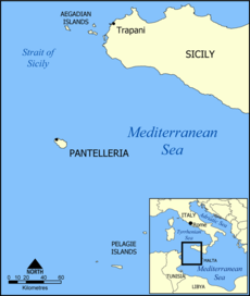 Pantelleria was formed by ancient volcanic action, but even as recently as 1891, there was a submarine eruption off its NW coast(j). This ancient vulcanism created large deposits of highly-prized obsidian on the island. Because of its importance for tool making, it was traded extensively in the Central Mediterranean from the Neolithic period onwards(g).
The island, formerly known as Cossyra, is an Italian-controlled island between Sicily and Tunisia. One suggestion, from Andis Kaulins has been that it was the original Gaderia(a).
This conclusion is probably based on the existence of a location on the northeast coast of the island called Gadir. However, it must be kept in mind that Gadira or variants of it are frequently found in the Mediterranean region, usually at the site of former Phoenician settlements. However, north of Pantelleria is the Egadi Islands(c), another name evocative of Plato’s Gades.
Gades has been associated with Erytheia in the story of the Trials of Hercules, so if the Map Mistress website is correct in locating Erytheia(d) between Pantelleria and the Egadi Islands, it would confine all the ‘Trials’ in the Central and Eastern Mediterranean, consequently, locating the Pillars of Heracles somewhere in the latter region.
More recently, some authors have identified the Straits of Sicily as being the location of the Pillars of Heracles referred to by Plato in his tale of Atlantis. A land bridge between Sicily and Tunisia, including Pantelleria, has also been suggested, but this is considered unlikely according to bathymetric data.
Novelist Samuel Butler (1835-1902) identified Pantelleria as Calypso’s Island, but the idea received little support(i).
A fortified Neolithic village has been unearthed on its west coast and ancient structures, known as ‘sesi’, similar to the nuraghi of Sardinia, are to be seen in the southeast. One in particular, known as the Grande Sese, is a 5,000-year-old six-metre high mausoleum, containing twelve ‘cells’. “The civilization who built this and another sese nearby are believed to have settled on the island after arriving from Northern Africa.”(h)
In 2005, jewellery in the style of the Egyptian Second Intermediate Period (1700-1550 BC) was discovered on the island. This would add to the opinion that Pantelleria was a major trading and cultural crossroads in ancient times.
Massimo Rapisarda has commented that “a good candidate to host a primordial civilization might have been the archipelago then existing in the Strait of Sicily, a natural maritime link between Tunisia and Italy, prized by the presence of an obsidian source at Pantelleria.”(f)
In August 2015, it was claimed(b) that a manufactured stone column was found on the Pantelleria Vecchia Bank, just north of the island of Pantelleria, in 40 metres of water. It is claimed that the area was formerly the site of an archipelago, if not actually connected to Sicily, before the last Ice Age ended around 7350 BC. The monolith was dated using shells extracted from it. It took no time before the discovery was linked by a number of sites with Plato’s Atlantis. While I believe that the area was part of the Atlantean domain, I am more inclined to date its expansionist intentions to a much later period, such as the 2nd millennium BC.
(a) https://web.archive.org/web/20200130221548/http://www.lexiline.com/lexiline/lexi60.htm
(c) https://web.archive.org/web/20180627052748/http://www.mapmistress.com/egadi-islands-marettimo-levanzo-favignana.html (text only)
(d) https://web.archive.org/web/20180831115550/http://www.mapmistress.com/pantelleria-erytheia-sicily-tunisia.html (text only)
(e) Stone Pages Archaeo News: Ancient Egypt gems on Italian isle (archive.org)
(g) https://www.academia.edu/33910010/Characterization_of_obsidian_sources_in_Pantelleria_Italy
Cádiz

Caduz 1813
Cádiz in southwestern Spain is accepted as the modern name for ancient Gades considered the original kingdom of Gadeirus, the twin brother of Atlas. However, the certainty normally associated with this accepted identification is weakened by the fact that quite a number of locations with similar-sounding names are to be found in the Central and Western Mediterranean regions.
A Map of Cadiz circa 1813 is shown on the right.
It has also been suggested that the name Cadiz came from Gadir, which in turn was derived from Kadesh(d)!
 The Spanish historian, Adolfo Valencia wrote a history of Cádiz[0208], in which he suggested that Atlantis might have extended from Cádiz to Malta.>>A much earlier history [0403] was produced in 1597 by Augustin de Horozco {4467mP}.<<
In 1973, Maxine Asher led an expedition to search for Atlantis off the coast of Cadiz, which despite claims of having discovered Plato’s Island, nothing verifiable was found(a). These claims received global press attention, enabling Asher to dine out on it for the rest of her fraudulent life.
It is generally accepted that the Phoenicians from Tyre founded Gadir, later to be known as Gades to the Romans. The Roman historian, Velleius Paterculus (c.19 BC – c.31 AD) wrote that Cadiz was founded 80 years after the Trojan War, circa 1100 BC. In the 9th century BC, the Phoenicians, under Princess Dido, founded a new capital at Carthage in North Africa. At Gades, the Phoenicians/Carthaginians built a temple to Melqart that had two columns, which many consider to be the original Pillars of Hercules. In 2007, it was announced that excavations in the old town centre produced shards of Phoenician pottery and walls dated to the 8th century BC, probably making it the oldest inhabited city in Europe.
In early January 2022, “Archaeologists from the University of Seville and the Andalusian Institute of Historical Heritage claim to have discovered the lost Temple of Hercules Gaditanus. Using information they obtained from documentaries and aerial photographs, the researchers found a large rectangular structure submerged in the Bay of Cadiz. (b)
The structure, nearly 1,000 feet long, 500 feet wide, and matches the ancient descriptions of the temple, is only visible in low tide.”
In September 2023, the latest attempt to revive interest in a Spanish Atlantis was unveiled at a press conference in Chipiona, near Cádiz. The theme of the conference was the discovery of long underwater curved walls that some have claimed to match exactly Plato’s description of Atlantis.
Thorwald C. Franke(c) has more on the background to this effort to put the spotlight on the possibility of Atlantis being situated in this region of Spain, which lies at the southern end of the Doñana Marshes that had received extensive investigation over the past couple of decades. The press conference was also used to announce the showing of a new documentary series by Michael Donnellan, on October 8th in Cádiz.
Also See: Egadi Islands
(a) 1973 Atlantis Expedition (fourth-millennium.net)
(b) Spanish Archaeologists Claim to Have Discovered The Temple of Hercules (sputniknews.com)
(c) Atlantis Newsletter Archive – Atlantis-Scout
(d) Atlantis Rising Forum (Tribes of Atlantis, 2003)
Gades
Gades is the Roman name of what is generally accepted as having been located at or near modern Cadiz in southern Spain. In his Critias, Plato relates that the twin brother of Atlas, the first ruler of Atlantis, was named Gadeiros although known in Greek as Eumelos. It is assumed that he had his realm in the vicinity of Cadiz and had his capital named, Gadeira, after him.
However, it has been pointed out that the Phoenicians, who, before the time of Plato, possessed a port city in southwest Spain named Gadir, meaning ‘enclosure’ or ‘fortress’ and was, over time, corrupted to Cadiz.
 Until recently, it was generally accepted, based on classical writers, including the historian Livy, that the Phoenicians founded Gades around 1100 BC. Writers today, such as, Mark Woolmer, have pointed out [1053.46] that the archaeological evidence suggests a more recent date, perhaps the middle of the 8th century BC. Around 500BC it was occupied by the Carthaginians and after that, eventually became Romanised.
However, a number of locations with similar-sounding names are to be found in the Central and Western Mediterranean region, weakening the certainty normally associated with the more generally accepted identification of Gadeirus’ city with South-West Spain.
Another solution has recently been proposed by the late Michael Hübner, in which he offers the Souss-Massa plain of Southern Morocco as the location of Atlantis. On the Atlantic coast of the plain is the large town of Agadir, whose name is also probably derived from the word ‘gadir’ which means fort or enclosure in the local Tamazight language. It can also mean ‘sheep fold’, which may tie in with Plato’s use of ‘Eumelos’ as the Greek translation of Gadeiros means ‘rich in sheep’.
Alternative suggestions have been proposed, including one by Andis Kaulins(a), who is inclined to identify the islands of Egadi (Aegadian), off the west coast of Sicily, which is opposite today’s Tunis. Should this Egadi be the original Gades, it would make sense for two of the suggested alternatives for the location of the Pillars of Heracles, either the Strait of Messina or the Strait of Sicily, where there is a Gadir on the island of Pantelleria(b). It would mean that Egadi would have been outside the Pillars of Heracles from either an Athenian or Egyptian perspective. Albert Nikas has pointed out the existence of a place in Malta called Il Ghadira, which has the largest sandy beach on the island!
A number of investigators have also identified Gades with Tartessos, presumed to be the Tarshish of the Bible.
More recently Jonathan Northcote, has suggested that Gadeira may have been Ireland, citing Strabo, who quoted Eratosthenes, who had noted that Gades is five days sailing from the ‘Sacred Promontory’. Wikipedia lists(d) eleven promontories stretching from Crimea to Wales that have been so named, but notes that these were only some of the locations given that designation. So he arbitrarily chose either of the two Portuguese Capes listed as the most likely starting point for a five-day journey to Ireland (Gadeira)!
Stuart L. Harris has echoed this, employing linguistic gymnastics(c). He uses Felice Vinci‘s idea that Homeric Greek was in fact a form of Finnish and so Gadeira was Käde Eiran, meaning ‘Hand of Eira’, supposedly a variant of Éire (Ireland) and consequently Atlantis lay to the west of Ireland. Convoluted, is an understatement.
(a) Pillars of Heracles – Alternative Location (archive.org)
Eumelos
Eumelos is the Greek name given to Gadeiros, the twin brother of Atlas. The name itself can be translated as ‘good music’. According to the text of Critias, he appears to have been given the portion of Atlantis nearest the Pillars of Heracles as his domain. This area, according to Plato, is called Gades after Eumelos’ original name in the language of the region, Gadirus. It is generally accepted that Gades is modern Cadiz.
However, a case can also be made for alternative locations such as Agadir in Southern Morocco or the Egadi Islands off the west coast of Sicily. The latter has gained in significance as support has grown for placing the ‘Pillars’in the Central Mediterranean at either the Strait of Messina or the Strait of Sicily.
Galanopoulos, on the other hand, believed that the Pillars of Heracles were at the south-eastern tip of the Peloponnesus and that the nearest Minoan island, Melos, may have been named after its first king Eumelos.
It is worth mentioning that a stone was discovered on Thera with the name Eumelos inscribed on it in archaic Greek, but the importance of this could be easily overplayed.
Egadi Islands
The Egadi Islands are located off the west coast of Sicily and were the location for a naval battle in 241 BC that resulted in the defeat of the Carthaginians by the Romans which brought an end to the First Punic War.
At the height of the last Ice Age, the islands were connected by a landbridge to the Sicilian mainland, because of the lower sea level(c). They have been suggested by Andis Kaulins(a) as the location of the kingdom of Gadirus, who was the twin brother of Atlas, the first king of Atlantis. Until recently, it was generally accepted that the 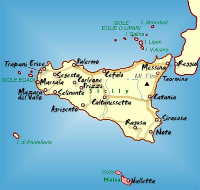 realm of Gadirus had been situated in the vicinity of modern Cadiz, known in ancient times as Gades. This idea was enhanced by its proximity to the Strait of Gibraltar, deemed by many to be the site of the Pillars of Heracles.
However, there has been growing support for the idea of the Pillars, referred to by Solon/Plato, being situated in the Central Mediterranean, at either the Strait of Messina or the Strait of Sicily, the latter supported by Andis Kaulins, who goes further and suggests a link between Tartessos and ancient Carthage across the Strait in Tunisia.
More recently, Albert Nikas has argued cogently(b) for placing the Pillars of Heracles in the vicinity of the Egadi Islands and identifying them with Plato’s Gades and then concluded that Malta had been ‘the island in front of the Pillars’ and was Atlantis.
>Ernle Bradford made one passing reference to Atlantis in Ulysses Found [1011.57] which may be of interest to supporters of a Central Mediterranean Atlantis. When discussing the Egadi Islands off the west coast of Sicily he describes Levanzo, the smallest of the group as being “once joined to Sicily, and the island was surrounded by a large fertile plain. Levanzo, in fact, was joined to more than Sicily. Between this western corner of the Sicilian coast and the Cape Bon peninsula in Tunisia there once lay rich and fertile valleys-perhaps, who knows, long lost Atlantis?” This would seem to be close to the views of Alberto Arecchi and others.<
If the name of the Egadi Islands is more than just evocative of Plato’s Gades and since Gades has also been associated with Erytheia in the story of the ‘Trials of Hercules’, then if Izabol Apulia’s Map Mistress website is correct in locating Erytheia(d) between Pantelleria and the Egadi Islands it would confine all the ‘Trials’ in the Central and Eastern Mediterranean, consequently, locating the Pillars of Heracles somewhere in that region.
Opposite the Egadi Islands on the mainland of Sicily is the port of Marsala(e), which has also been identified, by Massimo Rapisarda, as another possible location for Atlantis.
(a) Pillars of Heracles – Alternative Location (archive.org)
(b) http://atlantisonline.smfforfree2.com/index.php/topic,20615.0.html
(c) http://www.sci-news.com/archaeology/article00749.html
(d) Pantelleria & Erytheia: Southwest Sicily Sunken Coastline to Tunisia (archive.org)
Nika, Al
Al Nika (Albert Spyro Nikas) is a computer scientist working in New York. He is the latest to weigh in behind the idea of Atlantis having been located in the vicinity of Malta. In a paper(a) prepared for the 2008 Atlantis Conference in Athens, Nika outlines his ideas. He emphasises that the Atlantis story had an Egyptian orientation which was facing north. Applying his fluency in ancient Greek, he concludes that the Egyptian priests were referring to a number of different seas contained within the Mediterranean. One of these was situated beyond the Pillars of Heracles, which he believes were located on the Egadi Islands(b) off the west coast of Sicily. He concludes with the claim that the Maltese archipelago is the remains of Atlantis. His paper is well worth a read.
Nika has claimed that the name ‘Atlas’ in Greek could be read as ‘Malta’ in Etruscan, which upset the excitable Diaz-Montexano, who denounced it(c). Nika responded in defence of his claim(d).
In 2016, Nika revamped his website(e).
Sunday November 19th saw the publication of an article(f) by Nika in Malta’s Sunday Independent, in which he describes his recent visit to the many temples in the archipelago. He goes on to claim that he has located the ruins of an ancient city, just offshore, not far from Valletta, which he believes to have been the capital of Atlantis.
He reported his findings to Heritage Malta, providing them with images and coordinates, but, so far, has had no positive response. Nika is anxious that the site be confirmed by the authorities and then secured, but the apparent lack of interest from that quarter prompted him to conclude his article with the promise that “if I don’t hear anything from the authorities within a short time I will be obligated to reveal the location of the find to the Maltese people, after all, it is part of their history and they have the right to know about it.”
Nika is currently (2019) finishing a book that will explain in greater detail his theories regarding ancient Malta and Atlantis.
(a) http://web.archive.org/web/20170709143102/https://atlantipedia.ie/samples/archive-2880/
(b) https://atlantisonline.smfforfree2.com/index.php/topic,20615.0.html
(d) https://atlantisonline.smfforfree2.com/index.php/topic,24064.0.html
(e) See: https://web.archive.org/web/20181115153817/https://www.atlantisinmalta.com/
(f) Maltese temple builders and their enigmatic capital – The Malta Independent (archive.org)