Latest News

Joining The Dots
I have now published my new book, Joining The Dots, which offers a fresh look at the Atlantis mystery. I have addressed the critical questions of when, where and who, using Plato’s own words, tempered with some critical thinking and a modicum of common sense.Read More »
Ulf Richter
Edward, David
David Edward is the author of Atlantis Solved: The Final Definitive Proof [1296], a slender 99-page volume published in 2022 that endeavours to prove that the Richat Structure was the location of Atlantis. The author claims to have been inspired by videos by Jimmy Corsetti, on the Bright Insight YouTube channel, who has been promoting the Structure as Atlantis for the past four years.
This identification has no archaeological or geological evidence to support it and more importantly, it conflicts with Plato’s account. These shortcomings are dealt with in greater detail in the Richat Structure entry here. However, Ulf Richter has succinctly pointed out that the feature is too wide (35km), too elevated (400 metres) and too far from the sea (500km) to be seriously considered as the location of Atlantis. To which I would add that with well over 3,000km between them, to launch an attack on Athens from Richat would have been totally impractical.
It is now being trailed that Edward’s second book, Fingerprints of the Atlanteans, will be published in late 2023. We can expect this to be a reprise of his first book. The pre-publication blurb ends with the claim that “this book changes everything!” I have heard that so many times before(a)>and have always been disappointed. We can only hope that Edward does better this time rather than piggyback on Corsetti’s flawed ideas.<
(a) 25% OFF PREORDER – Fingerprints of the Atlanteans – A History Of (archive.org) *
Richat Structure, The
The Richat Structure or Guelb er Richat in Mauritania, ” is regarded by geologists as a highly symmetrical and deeply eroded geologic dome. It was first described in the 1930s to 1940s, as Richât Crater or Richât buttonhole. Richard-Molard (1948) considered it to be the result of a laccolithic thrust. A geological expedition to Mauritania led by Théodore Monod in 1952 recorded four ‘crateriform or circular irregularities” in the area.”(q)
The feature was thought by 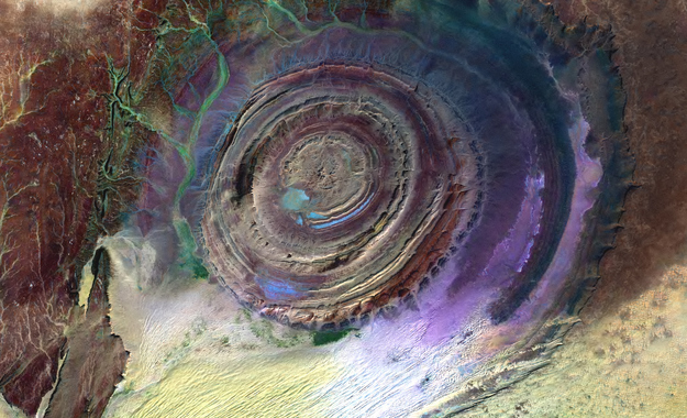 many to be an impact crater until it was identified as the remains of a possible ‘salt dome’(a). Some of the more enthusiastic supporters of the ‘Electric Universe’ school of thought have sought to identify the feature as the consequence of an electrical discharge.(e)
This is outlined in an April 2022 paper by Andrew Hall, explaining what he calls the ‘Keystone Pattern’.(r)
Even creationists have claimed that the original surface of the ‘Structure’ had been eroded by Noah’s Flood(t).
The concentric circles of which the structure is composed is clearly revealed by satellite imagery. However, these characteristics are not visible when walking across the structure(u). The scientific consensus today is that the structure is a natural geological feature. In more technical terms, a geological ‘dome’ is “A structure that plunges in all directions to form a circular or elongate structure is a dome. Domes are generally formed from one main deformation event, or via diapirism from underlying magmatic intrusions or movements of upwardly mobile, mechanically ductile material such as rock salt (salt dome) and shale (shale diapir). The Richat Structure of the Sahara is considered a dome that has been laid bare by erosion.”(k) Further geological data was available on a German website(v).
It did not take long before it was compared to Plato’s description of Atlantis. However, Ulf Richter has pointed out that it is too wide (35 km), too elevated (400 metres) and too far from the sea (500 km) to be seriously considered the location of Atlantis. Nevertheless, researchers such as Robert deMelo are still prepared to consider it a possible location candidate(b).
50 km west-southwest of Richat is a similar though smaller feature, the Semsiyat Dome, having a diameter of just 5 km(o).
A 2023 geological study(z) of the Richat feature is worth a read.
In 2008, George Sarantitis put forward the idea that the Richat Structure was the location of Atlantis, supporting his contention with an intensive reappraisal of the translation of Plato’s text(g). His theory has been published in Greek[1470], with an English translation now (2017) imminent.
In 2006 George S. Alexander and Natalis Rosen were struck by the similarity of the Richat feature with Plato’s description and decided to investigate on the ground. Instability in the region prevented this until late 2008, when they visited the site, gathering material for a movie. The film was then finalised and published on their then-newly-established website in 2010(c).
In 2008, Charles Giuliani self-published Alternative View of The Distant Past [1969]. In this wide-ranging book, the author tackles the story of Atlantis and endeavours to identify the Richat Structure as the location of Plato’s city of Atlantis. His speculations lack scientific evidence and contradict reason. The main weaknesses are his dating of Atlantis (9600 BC) and the logistical problems of launching an attack on Athens, 4,000km away from Richat, at a time when archaeology indicates that seafaring was carried out with little more than dugout canoes or rafts.
In 2013 further support for linking Atlantis with Richat came from Jose D.C. Hernandez, with a rather convoluted theory in a paper entitled A Celestial Impact and Atlantis(f).
Even more bizarre is the claim by Anthony Woods that although Ireland was the island of Atlantis, the city of Atlantis (Cerne) was in Mauritania and is known today as the Richat Structure!
Towards the end of the 2018 media ‘silly season’, the YouTube channel Bright Insight made a pathetic attempt to breathe new life into the Atlantis in Sahara theory. However, it fails on one simple fact; it is not submerged, but for good measure, when Alexander and Rosen investigated the Richat Structure, they could not produce a single piece of physical evidence from the 35 km wide site. Where was the bustling port described by Plato? I could go on, but remember, it’s not called the silly season without reason.
Early November 2018 saw the British tabloid press give further coverage to Jimmy Corsetti’s ideas(i)(j) (The Sun gave his name as Jimmy Bright!). His theories are totally dependent on the destruction of Atlantis having occurred around twelve thousand years ago. He does not explain how an attack was launched from Mauritania on Athens which did not even exist at that time. Corsetti, like many others, needs this very early date to explain why the Richat Structure is not underwater today, but was gradually uplifted as a result of tectonic forces in the region. However, Plato clearly states that the submerged Atlantis was still a hazard to shipping in his day, a period when the Structure would have been at its present elevation. As no geologic event has occurred during the two and a half millennia since Plato, which could have raised the Structure from the seabed to an elevation of 400 metres 500 km from the Atlantic, we are obliged to give greater credence to the scientific conclusion that the Richat Structure is a natural feature. Corsetti does have at least one fan(n).
It was in 2018 that Corsetti published a video promoting the Richat Structure as Atlantis, which received extensive coverage. Steven Novella, a well-known Atlantis sceptic, published an article debunking Corsetti’s ‘evidence’ in some considerable detail(s). However, while I would endorse Novella’s arguments(l) regarding the Richat Structure, I strongly disagree with Novella’s closed-minded attitude towards the existence of Atlantis as well as Corsetti’s attention-seeking location choice for Plato’s island. I would add that Corsetti has his date wrong and that to launch an attack on Athens nearly 4000 km away by land (3000 km by sea) from the ‘Structure’ is logistical nonsense.
In a recent conversation with Joe Rogan, Corsetti claimed that since the Structure contains salt, it MUST have been submerged and no other explanation is possible. However, as I have pointed out above, the Richat feature is an eroded ‘salt dome’ and quite naturally has salt in it, without the need for submersion.
The natural geological origins of the Richat Structure are discussed in some detail in a 2005 paper by three Canadian scientists in the journal Geology, produced by the Geological Society of America. It would be interesting to hear the response of Corsetti to facts compared with his daft speculations(w).
However, in 2018, Martin K. Ettington published a booklet entitled The Real Atlantis [1641] in which he also insisted that the Richat Structure is the remains of Atlantis but with no real evidence to support his contention.
In Joining the Dots [1590] and in Atlantipedia.ie I have consistently argued that in ancient times, proximity is an essential logistical requirement in order to achieve a successful invasion. This was particularly true in ancient times when all empires expanded through the invasion of neighbouring territories. The Richat Structure is many thousands of kilometres from Athens, so to suggest that an attack was launched from Mauretania on Greece is simply ludicrous.
There is a relatively recent website(m) dedicated to promoting the ‘Structure’ as the location of Atlantis. It is well presented by its author, Gergely (Gregory) Dzsida, with plenty of content. Unfortunately, I cannot accept its basic claim. To my mind, it fails to answer Richter’s arguments regarding size, elevation and location, as well as my point regarding proximity.
Not unexpectedly, Jason Colavito has a few thoughts to add to this latest Atlantis in Sahara kerfuffle(h).
Although the Richat Structure, as the location of Atlantis, conflicts with details in Plato’s account as well as reason, it still gathers supporters based simply on its circular shape. A recent example of this came from a Danish commentator, Palle A. Anderson(p).
An even more ridiculous suggestion was offered in 2021 by Carlos Bisceglia in Atlantis 2021- Lost Continent Rediscovered, in which he proposed that Atlantis was known to the Egyptians as the ‘Land of Ma’ and that its capital was the Richat Structure, together with the Semsiat Dome, mentioned above, which is 50km away. In order to explain how his Atlantis is not submerged, Bisceglia has proposed that the Land of Ma became confused with the submerged Land of Mu (Sundaland) in the Pacific and that “it is possible that Solon or Plato confused ‘the Land of Ma’ with the ‘Land of Mu’, and thus two completely independent accounts were merged into one.” He adds, “how the Egyptian priests knew this is a mystery. Evidently, some survivors from Sundaland arrived in some way in Egypt”.
In April 2022, David Edward published Atlantis Solved: The Final Definitive Proof [1926], which also endorsed the Richat Structure as the location of Atlantis. The author of this slender 99-page book admits to being greatly influenced by the earlier claims of Jimmy Corsetti.Edward was obviously unhappy with my comments, so he wrote to me complaining that I was costing him hundreds of book sales a day, a claim supported by as much evidence as there is for the Richat Atlantis(y) .
In a 2021 paper(x), Thorwald C. Franke listed a number of reasons why ‘Richat’ cannot be considered as the location of Atlantis. He did not present his selection as definitive, but did claim that “our small list is already quite sufficient to establish that this hypothesis does not stand the slightest chance.”
Also in 2021, the prolific Shifu Careaga published a lengthy paper challenging Jimmy Corsetti’s Richat theory. At the start of the paper, he offered the following reasons for rejecting Corsetti’s claims.
“Mr. Corsetti’s hypothesis is clearly and definitively incorrect for all of the following reasons:
- That region of Africa has not been submerged in over 99 million years4, and its uplift and downthrust values are stable.
- At the time of the Younger Dryas, the sea level was lower and could not have made the richat area an island.
- The richat formation is not concentrically circular.
- It could never act as canals, or hold water.
- It is itself on a tilt (and we will look at the topographics and satellite data on this).
- There are no mountains immediately to the north.
- The Atlas Mountains are named for King Atlas, who was named for Atlantis (perhaps), not vice versa.
- The region is not 1000 miles past the Pillars of Heracles (straits of Gibraltar)
- The whale carcasses found are from clear fluvial megatsunami inundation, as Jimmy himself points out(aa)
Although not all on Careaga’s list are show-stoppers, but, when combined with the fundamental objections noted above from Ulf Richter, the Atlantis in Richat theory looks quite flimsy.
Another site expanded on the difficulties that the elevation of the Structure poses for Corsetti and Co, in the short excerpt below.
The Elevation Problem:
The Richat Structure is actually elevated above the surrounding terrain, not in a depression. The structure sits at about 400 feet (120 meters) above sea level, with the plateau standing some 200 meters above the surrounding desert sands, and the peak of the outer rim reaching 485 meters above sea level. The central rings are about 80 meters (260 feet) tall.
This creates exactly the drainage problem you identified – water would flow OUT of the structure, not into it. The concentric rings are actually ridges of harder rock (quartzite) that stand higher than the valleys between them.
Why Water Flow Wouldn’t Work:
It’s a dome, not a basin – The sedimentary rocks dip outward at 10-20°, meaning water would naturally flow away from the center.
No natural water retention – The “rings” are actually elevated ridges with valleys between them, but these valleys drain outward.
Distance from water sources – At 500km from the Atlantic Ocean and sitting on an elevated plateau, there’s no natural way for ocean water to reach it.
Limited catchment – Even during the humid Sahara period, the structure would shed water rather than collect it.
The Reality for Ancient Water Access:
Archaeological evidence shows the area was used for short-term hunting and tool manufacturing, with sediments containing freshwater fossils from playa lakes between 15,000-8,000 years ago, during the African humid period. But these were temporary seasonal lakes in the low areas, not a permanent water-based city. Any substantial water-based civilization here would have required massive engineering to: (1) Dam the outward-flowing valleys (2) Import water from distant sources or (3) Create artificial retention systems.
The natural topography actually works against water accumulation, which explains why no evidence of permanent large-scale habitation has been found in the structure itself.” (ac)
Caleb Howells began 2025 with a debunking of the claim that Atlantis had been situated in the Richat Structure in Mauritania(ab).
(a) https://web.archive.org/web/20160326200714/https://www.atlantis-schoppe.de/richter.pdf
(b) http://www.gpofr.com/documents/2012Atlantis.pdf
(c) Visiting Atlantis | Gateway to a lost world (archive.org)
(e) Earth’s Richat Crater (archive.org)
https://www.thunderbolts.info/tpod/2005/arch05/050407richat.htm
(f) https://blog.world-mysteries.com/science/a-celestial-impact-and-atlantis/
(g) The System of Wheels – Plato Project (archive.org)
(h) https://www.jasoncolavito.com/blog/youtube-video-claims-atlantis-is-located-in-the-sahara-desert
(i) https://www.thesun.co.uk/news/7681682/atlantis-sahara-desert-conspiracy/
(l) https://theness.com/neurologicablog/index.php/no-atlantis-has-not-been-discovered-in-north-africa/
(m) Learn from Ancient Civilizations | Find Atlantis Together (archive.org)
(o) Are the so-called impact craters in Mauritania kimberlite pipes ? (archive.org) (see the end of page)
(p) The Real Atlantis – where is it? (planker.dk)
(q) Richat Structure – Wikipedia
(r) The Keystone Pattern – The Thunderbolts Project™
(s) https://theness.com/neurologicablog/index.php/no-atlantis-has-not-been-discovered-in-north-africa/
(t) https://creation.com/eye-of-the-sahara
(v) richat description (archive.org)
(w) https://archipel.uqam.ca/272/1/Matton_etal05.pdf
(x) Against the 10,000 BC Belief Complex – Atlantis-Scout
(y) Private Correspondence.
(z) Eye Of The Sahara or Richat Structure » Geology Science
(aa) (PDF) Ashes of Atlantis – part 1 | Shifu Careaga – Academia.edu (archive.org)
(ab) https://greekreporter.com/2025/01/05/eye-sahara-lost-atlantis/
(ac) https://claude.ai/share/dcb21c98-40b4-422f-a168-986e6df6477b
Plethrum
The Plethrum (Plethron) is a Greek measurement of 100 Greek feet in length (101 English feet or about 30 metres) as well as 10,000 sq.ft. in area. It and its plural, plethra, are used in four instances in Critias (115d, 116a, 116d and 118c).
It is interesting to note that in one case (118c) Plato found the dimensions of the 10,000 stade ditch surrounding the plain of Atlantis as very hard to believe but felt obliged to record it out of deference to the reputation of his source, Solon. The text states that this ditch was dug by hand to a depth of a plethrum and a stade in width.
The late Ulf Richter argued that Solon had been given dimensions in Egyptian khets (52.4 metres) but that he had noted them as Greek stades (185 metres)(a).
He was forced to make this suggestion because he recognised that the dimensions for the plain of Atlantis as recorded by Plato must have been exaggerated. However, when it came to the ditch which surrounded the plain, he was also content to accept that the stade width of the ditch was excessive, but that the plethrum depth was acceptable because the clay banks would have been continually subject to slippage! Feasible, but for me, not totally convincing.
The most recent entrant into this particular debate is M.P. Courville [1960.10] who has proposed that Plato intended to use the plethrum, which is around 30 metres long or very roughly one-fifth the length of a stade. The problem arising from that idea is that Plato also uses the plethrum together with the stade in contexts where they both seem too large (Crit.116a & 118c)!
(a) CiteSeerX — Plato´s Atlantis was in a River Delta (archive.org)
Stade *
The Stade was an ancient Greek measurement of distance. The origins of the stade are not clear. One opinion claims that at first, it was the distance covered by a plough before turning. Later it was the length of a foot race in a Greek Stadion (Roman Stadium) or 157 meters. Different ‘standard’ stadia existed in various city-states of ancient Greece ranging from 157 to 211 meters.
Some commentators have treated the stade as a synonym for the British ‘furlong’ (one eight a mile or 220 yards – approximately 201 metres), which was an old Anglo-Saxon measure for a ‘long furrow’.
Nick Kollerstrom has published a paper on Graham Hancock’s website arguing that “Mother Earth was clearly the source of the Greek stade, though the ancient Greek philosophers do not seem to have been aware of this fact.”(e)
Most commentators on Plato’s Atlantis seem to accept a value of 185 metres (607 feet) to the stade. Thorwald C.Franke argues for a value of 176 metres – ” It is confusing: The building called “stadion” had been 185 meters, but the measure “stadion” not. We can conclude that the Athenians once had a shorter building, but decided to build a bigger building in later times. It is the same story for the “stadion” of other cities.” (private correspondence)
The problem that has arisen is that irrespective of whichever stade was used by Plato, the resulting dimensions suggested by him are unacceptably large. This has led quite a number of commentators to suggest that Plato’s use of the stade was possibly due to some misunderstanding or transcription error and have striven to find a more credible unit of measurement.
Jim Allen who is the leading advocate for a Bolivian location for Atlantis has used a value for the stade that is half the conventionally accepted 185 metres. He bases this on the fact that the ancient South Americans used a base of 20 rather than 10 for counting. He offers an interesting article with impressive images on his website(a) in support of his contention.
Dr Rainer Kühne, who recently publicised that a site in Andalusia, identified by Werner Wickboldt from satellite photos, suggested that Plato used a stade that was probably 20% longer than what is normally accepted since the dimensions of the Spanish site are greater than those given in Plato’s text. This idea is not satisfactory as so many other dimensions of the city’s features already suggest over-engineering on a colossal scale. To add a further 20% would be even more ridiculous.
If the dimensions of Atlantis did originate on the pillars in the temple at Sais, the unit of measurement used was probably Egyptian (or Atlantean) and so their exact value must be open to question. The values given by Plato relating to Atlantis have long been ammunition for sceptics. They argue that Plato’s topographical data suggests either a degree of over-engineering that was improbable in the Bronze Age or impossible in the Stone Age and must, therefore, be a fantasy.
In the 1930s and 1940s, there was a degree of confusion among those reluctant to accept that the Greek ‘stade’ was a reliable unit of measurement for the architectural features described by Plato in Atlantis. Alexander Braghine in 1940, seems to have the matter entirely confused when he wrote [156.58] about Albert Hermann‘s proposal of 1934 that the unit of measurement used by the Egyptians to describe Atlantis was the ‘shoinos’, which Braghine noted is 604 times shorter than a stade, which is completely wrong or just a misprint that should read 60! Earlier in 1937 James Bramwell also commented on Hermann’s suggestion that it was the Egyptian ‘schoinos’, which is equivalent to 30 stadia [195.117].
William Smith’s Dictionary of Greek and Roman Antiquities, noted that “SCHOENUS (?, ?, ???????), literally, a rope of rushes, an Egyptian and Persian itinerary and land measure (Herod. i. 66). Its length is stated by Herodotus (ii. 6, 9) at 60 stadia, or 2 parasangs; by Eratosthenes at 40 stadia, and by others at 112 or 30. (Plin. H. N. v. 9. s. 10, xii. 14. s. 30.) Strabo and Pliny both state that the schoenus varied in different parts of Egypt and Persia. (Strabo, p. 803; Plin. H. N. vi. 26. s 30; comp Athen. iii. p. 122, a.) [–Phillip Smith]”
An award-winning paper by Newly Walkup discusses in detail Eratosthenes attempt to measure the circumference of the Earth(f).
Today, Wikipedia proposes a conversion rate of 40 schoeni to the stade(c).
The late Ulf Richter proposed a simple solution to this problem(b), namely that the unit of measurement originally recorded was the Egyptian Khet. This was equivalent to 52.4 metres or approximately 3.5 times less than the value of the stade. The acceptance of this rational explanation removes one of the great objections to the veracity of the Atlantis narrative.
The most recent entrant into this particular debate is M.P. Courville [1960.10] who has proposed that Plato intended to use the plethrum, which is around 30 metres long or very roughly one-fifth the length of a stade. The problem arising from that idea is that Plato also uses the plethrum together with the stade in contexts where they both seem too large (Crit.116a & 118c)!
Jean-Pierre Pätznick commented in a paper on the Academia.edu website that “the 10,000-stadia ditch that would have surrounded the great plain on three sides would in fact have measured 1850 km long, 30.80 m deep and 185 m wide. A colossal structure that would have been 23 times larger than the Panama Canal and nearly 10 times larger than that of the Suez Canal!”(d)
It seems that all of Plato’s numbers, or at least all the larger ones, appear to be exaggerations and in my opinion, should be reduced by a common factor to bring them in line with credibility. I have elaborated more fully on this in Joining the Dots.
(a) https://web.archive.org/web/20200709181313/http://www.atlantisbolivia.org/atlantisstade.htm
(b) https://web.archive.org/web/20180728113519/http://www.atlantisbolivia.org/ulfrichterstade.htm
(d) Jean-Pierre Pätznick and the Egyptian Atlantis (atlantis-scout.de) *
(e) Ancient Units and Earth-Measure – Graham Hancock Official Website
Salt Domes
Salt Domes are the result of large deposits of salt laid down millions of years ago and subsequently covered by layers of sediment which in time became stratified rock. Over time, the deposits push upwards, as they are usually less dense than the overlying rock, creating domes. Erosion of these domes can produce a feature that has the appearance of a series of concentric circles. These domes can be many kilometres in diameter and in Kazakhstan have been numbered at 1,200(a).
Salt domes have been recently put forward as an explanation for the circular waterways of Atlantis, as described by Plato. Ulf Richter has proposed(a) that if one such dome had originally been overlaid with strata of varying hardness, the effects of erosion could have produced a number of concentric depressions that could have been adapted as canals. Richter provides a diagram illustrating how they are created and gives the Richat Structure in Mauretania as a good example of the process.
Richter outlined this in a paper presented to the 2005 Atlantis Conference [629.451].
The most famous salt dome associated with Plato’s Atlantis is the aforementioned Richat Structure. Despite completely lacking archaeological evidence, a number of commentators have enthusiastically embraced the Structure as its location.
However, Ulf Richter has pointed out that it is too wide (35 km), too elevated (400 metres) and too far from the sea (500 km) to be seriously considered the location of Atlantis. The Richat Structure is nearly three thousand miles from Athens, so to suggest that an attack was launched from Mauritania on Greece is simply ludicrous.
(a) http://web.archive.org/web/20200215123432/https://atlantipedia.ie/samples/archive-6142/
Sahara Desert
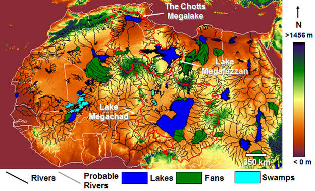
The Sahara Desert and in particular, its northern regions have attracted its share of attention from Atlantis investigators. However unlikely it may appear as a possible location for Atlantis, it must be kept in mind that the Sahara of prehistory was very different from what we see today. Not only was it wetter at various periods in the past, but also there is clear evidence for the existence of a large inland sea extending across the borders of modern Algeria and Tunisia. This evidence is in the form of the chotts or salt flats in both countries. This proposed sea is considered by some to have been the Lake Tritonis referred to by classical writers. It is suggested that some form of tectonic/seismic activity, common in the region, was responsible for isolating this body of seawater from the Mediterranean and eventually turning it into the salt flats we see today.
An even more extensive inland sea, further south, was proposed by Ali Bey el Abbassi and based on his theory, a map was published in 1802 which can be viewed online(c).
More recently, Riaan Booysen has published an illustrated paper on the ancient inland Saharan seas as indicated on the 16th-century maps of Mercator and Ortelius(i). King’s College London runs The Sahara Megalakes Project, which studies the Megalakes and the Saharan Palaeoclimate record(m). The largest of these was possibly Lake Chad, which at its most extensive is estimated to have been greater than the combined Great Lakes of North America.
 A 2013 report in New Scientist magazine(d) revealed that 100,000 years ago, the Sahara had been home to three large rivers that flowed northward, which probably provided migration routes for our ancestors. Depending on how long the African Humid Period(z) lasted, this article may be read in conjunction with George Sarantitis‘ theory regarding the Voyage of Hanno which he claims took place in the interior of Africa.
Other studies(h) have shown the previous existence of a huge river system in the Western Sahara, which flowed into the Atlantic on the Mauritanian coast.
An article in the Sept. 2008 edition of National Geographic article by Peter Gwinpointed out that the Saharan climate has been similar for the past 70,000 years, except for a period beginning 12,000 years ago, when a number of factors combined to alter this fact. A northerly shift by seasonal monsoons brought additional rain to an area the size of the contiguous USA. This period of a greener Sahara lasted until around 4,500 years ago.
More recent studies claim that “there’s geologic evidence from ocean sediments that these orbitally-paced Green Sahara events occur as far back as the Miocene epoch (23 million to 5 million years ago), including during periods when atmospheric carbon dioxide was similar to and possibly higher than today’s levels. So, a future Green Sahara event is still highly likely in the distant future.” (p)
However, in the Sept. 2024 edition of National Geographic an article Peter Gwin notes that “the Sahara hasn’t always been a desert. In fact, it transforms from desert to lush savanna about every 21,000 years. A quirk in Earth’s planetary mechanics periodically causes its axis to tilt slightly, increasing the amount of radiation directed to the Northern Hemisphere, which in turn pulls Africa’s seasonal rains northward.”
Henri Lhote contributed an article to Reader’s Digest‘s, The World’s Last Mysteries [1083], regarding the ‘green’ Sahara that existed prior to 2500 BC. Two German climatologists, Rudolph Kuper and Stefan Kröpelin, have estimated that this last greening of the Sahara began around 8500 BC and ended sometime between 3500 BC and 1500 BC(r)(u) .
A team from the Potsdam Institute for Climate Research, led by Professor Martin Claussen, published a number of papers in the late 1990s following their production of a successful computer simulation of prehistoric North Africa(v). According to a report on the climateark website (now offline), one of their conclusions was “that the change to desert climate in the Sahara was triggered by changes in the Earth’s orbit and the tilt of Earth’s axis.”
Some, such as Kröpelin, have suggested a connection between the latest aridification of the Sahara and the migration of settlers to the Nile Valley(w), where, coincidentally, the ancient Egypt we know about was founded around 3100 BC.
Others have endeavoured to link the last drying of the Sahara with the destruction of Atlantis!
More recently, human activity has been blamed as a major contributory factor for the desertification of the Sahara region less than 10,000 years ago.(n)
Related to the above is a recent study of sediments off the west coast of Africa, which resulted in the discovery of what was “primarily a new “beat,” in which the Sahara vacillated between wet and dry climates every 20,000 years, in sync with the region’s monsoon activity and the periodic tilting of the Earth.” (o)
In Mauritania, a huge natural feature known as the Richat Structure has been claimed as the remnant of Atlantis by George Sarantitis [1470] as well as by Alexander & Rosen and others. However, Ulf Richter has pointed out that it is too wide (35km), too elevated (400metres) and too far from the sea (500km) to be seriously considered as the location of Atlantis. Apart from which, a scientific study of the Structure reveals it to be a natural feature(x).
In 1868, it was proposed by D.A. Godron, the French botanist, that the Sahara was the location of Atlantis. In 2003, the non-existent archaeologist Dr.Carla Sage announced that she was hoping to lead an international expedition to the Sahara in search of Atlantis. Her contention was that “Atlantis was the capital of a vast North African empire with ports on the Gulf of Sidra”. This report is now confirmed to have been a hoax! I am indebted to Stel Pavlou for uncovering the origin of this story(e).
The idea of an African Atlantis was highlighted in 2021 with the publication of Atletenu [1821], in which the author, Diego Ratti, identified the Hyksos as Atlanteans with their capital at Avaris in the eastern Nile Delta. At the other end of North Africa, the chotts of Tunisia and Algeria were nominated by Holden Zhang as the location of Atlantis in a YouTube clip(q).
Gary Gilligan, the well-known catastrophist, wrote a thought-provoking article(k) on the origin of the Saharan sands, which he claims are extraterrestrial in origin and expands on the idea in his 2016 book Extraterrestrial Sands [1365]. A March 2024 report(t). on the BBC website has revealed that a particular type of sand dune has now been dated. They are known as ‘star’ or ‘pyramid’ dunes – “are named after their distinctive shapes and reach hundreds of metres in height.” They are found in Africa, Asia and North America, as well as on Mars – but experts had never before been able to put a date on when they were formed. Now scientists have discovered that a dune called Lala Lallia in Morocco formed 13,000 years ago.”
David Mattingly, an archaeologist at Leicester University, has found that an ancient people known as the Garamantes had an extensive civilisation in the Sahara(l). He has evidence of at least three cities and twenty other settlements. The Garamantes reached their peak around 100 BC and then gradually diminished in influence as fossil water supplies reduced until, in the 7th century AD, they were subjected to Islamic domination. Some researchers such as Frank Joseph have identified the Garamantes as being linked with the Sea Peoples. Bob Idjennaden has published short but informative Kindle books about both the Garamantes [1194] and the Sea Peoples [1195], without a suggestion of any connection between the two.
A 2017 article on the Popular Archaeology website told us that “New research investigating the transition of the Sahara from a lush, green landscape 10,000 years ago to the arid conditions found today, suggests that humans may have played an active role in its desertification.” (n).
The discovery of megalithic structures discovered at Nabta Playa (Nabta Lake) in the Egyptian Sahara has provided evidence for the existence of a sophisticated society in that area around 5000 BC. In the same region, near the Dakhleh Oasis, archaeologists have produced data that supports the idea that pre-Pharaonic Egypt had Desert Origins rather than being an importation from Mesopotamia or elsewhere(a).
Nabta Playa is not unique; in fact, the largest megalithic ellipse in the world is to be found at Mzorah, 27 km from Lixus in Morocco(b). It appears that the construction methods employed at both Mezorah and Nabta Playa are both similar to that used in the British Isles. An even more impressive site is Adam’s Calendar in South Africa, which has been claimed as 75,000-250,000 years old.
West of Cairo near the border with Libya is the Siwa Oasis, where it has now been demonstrated that “it is in fact home to one of Ancient Egypt’s astounding solar-calendar technologies– the solar equinox alignment between the Timasirayn Temple and the Temple of Amun Oracle in Aghurmi.”(j).
I think we can expect further exciting discoveries in the Sahara, leading to a clearer picture of the prehistoric cultures of the region and what connections there are, if any, with Plato’s Atlantis. In the meantime in the Eastern Egyptian Desert, Douglas Brewer, a professor of archaeology at the University of Illinois, has discovered over 1,000 examples of rock art, including numerous depictions of boats, although the sites, so far undisclosed, are remote from water.
Even more remarkable is the report(e) of March 2015 that a survey of the Messak Settafet escarpment in the central Sahara revealed that there were enough discarded stone tools in the region “to build more than one Great Pyramid for every square kilometre of land on the continent”! Coincidentally, around the same time, it was reported that over a thousand stone tools had been found in the Northern Utah Desert(g). What the Utah discovery lacked in quantity was made up for in quality with the finding of the largest known Haskett point spearhead, measuring around nine inches in length(y) .
(a) Saudi Aramco World (2006, Vol. 57, No.5 p.2-11)
(c) https://web.archive.org/web/20201019061756/http://catalog.afriterra.org/zoomMap.cmd?number=1036
(d) NewScientist.com, 16 September 2013, https://tinyurl.com/mg9vcoz
(f) https://www.cam.ac.uk/research/news/saharan-carpet-of-tools-is-the-earliest-known-man-made-landscape
(i) 7. The lakes in the middle of the Sahara desert – Page 8 (archive.org)
(l) http://web.archive.org/web/20191216194846/https://atlantipedia.ie/samples/archive-3268/
(n) https://popular-archaeology.com/issue/winter-2017/article/did-humans-create-the-sahara-desert
(o) https://phys.org/news/2019-01-sahara-swung-lush-conditions-years.html#jCp
(p) https://www.livescience.com/will-sahara-desert-turn-green.html
(q) Revive Eden 3 Convincing Atlantis – YouTube
(r) (Smithsonian. Feb 2010) https://www.smithsonianmag.com/history/uncovering-secrets-of-the-sphinx-5053442/
(s) https://las.illinois.edu/news/2006-09-01/oasis-art-egyptian-desert
(t) (BBC Mar.4, 2024) Star dune: Scientists solve mystery behind Earth’s largest desert sands – BBC News
(u) Shift From Savannah to Sahara Was Gradual, Research Suggests – The New York Times (nytimes.com)
(x) Eye Of The Sahara or Richat Structure » Geology Science
(y) https://archaeology.org/news/2015/04/06/150406-utah-haskett-point/
(z) https://en.wikipedia.org/wiki/African_humid_period
McQuillen, R(ich)
R(ich) McQuillen is an American investigator who has cogently argued for an Egyptian location for Atlantis. He has diligently gathered an impressive array of evidence from classical writers, including Hellanicus, Solinus and Aeschylus, to support his view and arranged the morass that is Greek mythology to construct a credible timeframe for the Atlantis narrative.
However, McQuillen is not the first to locate Atlantis in or near Egypt, in fact, the earliest I have found is in the late 19th century by A.N. Karnozhitsky, while the most recent was published by Diego Ratti in 2021.
McQuillen places the Pillars of Heracles at Canopus, which was formerly in the Western Nile delta but is now submerged about 6.5 km from the coast in the Bay of Aboukir. He is also of the opinion that the Egyptians used lunar cycles’ rather than solar years, bringing the backdrop to the Atlantis story into the 2nd millennium BC. However, he now seems to favour the ‘factor ten’ interpretation of Plato’s date.
McQuillen locates Atlantis at Pharos, which was near modern Alexandria. His website(a) is well worth a visit.
Extensive underwater excavations in the region have been undertaken in recent years by Franck Goddio and his team with remarkable results (b).
It is also worth noting that the late Ulf Richter reasoned that a river delta was the most likely topographical setting for Atlantis (c).
In March 2022 McQuillen added six papers(d-i) expanding on background details employed in his interpretation of the Atlantis story. All six are available on the Academia.edu website.
In 2020, McQuillen published A Simple Chronology of Greek Mythology(k) adding a further paper(j) in 2022 which offered a radical reappraisal of Biblical chronology that included the following.
1 People have been questioning Standard Biblical Chronology (the literal times) for 2000 years, and yet this still persists in modern Biblical Archaeology
2 I have thrown out the early dates entirely and introduced a different paradigm to try to find some of these elusive characters. This paper talks about the Pre-Noachian Kings, like Cainan, and links him to the real-world Syrian Hyksos King Khyan, and finds archaeological evidence of the existence of other Hyksos Kings.
3 It links the flood of Noah to the flood of Ahmose and Atrahasis, and shows it to be a real flood caused by Santorini.
4 It finds Jacob at the same time as the Israel stele of Merneptah. It finds Joseph as the Semitic Pharoah Siptah, whose mother has the same name as Jacob’s second wife. It finds Moses around the time of the Smallpox plague in Egypt (ranging from Ramses 4 to 9)(1182?1136BC).
In his paper ‘Perfecting Plato’, McQuillen is critical of some available translations available to us, of passages in Plato’s Atlantis texts. In his summary of the paper “There are a bunch of controversial passages within the Timaeus. This has led to 50k books on the topic with a bunch of different interpretations of the same passages. These stem from mistranslations, intentional mistakes, wild speculation, etc… The purpose of this paper is to identify and correct the mistakes and add additional insight. The Timaeus is long and in most parts, well-translated and irrelevant, so I’m selecting only interesting passages, where I can add insight. I’m using the Bury Translation, with a little bit of Calcidius thrown in.
Plato’s myth has been described as a fable and a description of an idealized society. Instead, it was intended as a story about 18th dynasty Egypt, and its interactions with the Haunebu (Aegaens). The past is often romanticized and idealized in the history books; History is written by the winners.” He then proceeded to comment on several specific passages in Timaeus(h).
In 2024, McQuillen published a new paper(l) focused on the work of Manetho. “This paper explores other Egyptian Sources to verify the veracity of Plato’s tale; specifically, intends a lot of the peculiarities in Plato’s text, that also exist in Manetho’s writings. Plato says this tale comes from Solon in the days of Amasis; there are, in fact, Egyptian elements within this tale which were not invented by Plato, and can be confirmed to also exist in the Egyptan writings from Manetho and others. Manetho specifically does mention 9000 years, and a war, and a flood, and a city, similar to Plato.”
In this more recent paper, he identifies Avaris as the City of Atlantis although as you can see above he previously(2007) named Pharos, near Alexandria. In the same paper he also identifies the Atlantean Gadir with Rhakotis, an ancient city near Alexandria.
In 2020, McQuillen published the first draft of A Simple Chronology of Greek Mythology, in which he was inspired by Herodotus to develop his own methodology and applied it to the histories of Athens, Crete and Egypt(m). He concluded, “I have attempted to create a mythological timeframe for a majority of the Greek Mythological Kings in Greece. These timeframes have been tied to real world events like Troy. They have been synchronized with known timeframes of Egyptian Pharaohs. I list the kings of 20 different ancient cities and attempted to synchronize their history. I have created a framework to compare likes with likes and show when and where one might expect to find these names in Archaeology.”
In 2025 McQuillen published a new paper in which he claimed that “the story of Atlantis is a history of 18th dynasty Egypt in its entirety and some of their interactions with Greece from a Greek Mythological Perspective,” and that “the story of Atlantis actually names 3 disparate groups as Atlanteans: A) Syrian Hyksos. B) Egyptian Pharaohs. C) Aeolian Greeks. This conflation is the single biggest problem with the Atlantis story, in my opinion.” (o)
Also in 2025, the Hungarian researcher, Sándor Csizi, published a paper with the enticing title of The Last Port of Atlantis, referring to Pharos(n).
(a) http://gizacalc.freehostia.com/Atlantis.html
(b) Franck Goddio: Homepage (archive.org)
(c) http://web.archive.org/web/20210625010715/https://atlantipedia.ie/samples/archive-6142/
(d) https://www.academia.edu/43493561/A_Simple_Chronology_of_Greek_Mythology_First_Draft
(e) https://www.academia.edu/69049558/Dissecting_Diodorus_The_Legend_of_Myrina_and_Orus
(f) https://www.academia.edu/76436465/Finding_a_God_Phaethon_King_Tut_and_the_Amarna_Period {link broken}
(g) https://www.academia.edu/76548637/Defining_Danaus_and_Egyptus
(h) https://www.academia.edu/76880053/Perfecting_Plato_A_colorful_commentary_on_the_Timaeus
(i) (DOC) Perfecting Plato: A colorful commentary on the Critias – Part 1 (archive.org)
(j) (99+) A Simple Chronology for Biblical Archaeology | Rich McQuillen – Academia.edu
(k) https://www.academia.edu/43493561/A_Simple_Chronology_of_Greek_Mythology_-First_Draft
(l) (99+) Manifesting with Manetho: Finding commonality from Plato’s Atlantis and Egyptian Sources | Rich McQuillen – Academia.edu (link broken)
(m) (99+) A Simple Chronology of Greek Mythology -First Draft | Rich McQuillen – Academia.edu
(n) https://www.academia.edu/128445192/THE_LAST_PORT_OF_ATLANTIS
(o) (76) Rebuilding Atlantis with the help of Hatshepsut (academia.edu)
Location Theories
Location Theories regarding Atlantis have identified sites all over the globe as shown below. In very general terms, the 15th century saw three developments that led to a renewed interest in Atlantis – the discovery of America, the first translation of the complete works of Plato by Ficino and the invention of the printing press. These saw a number of commentators offering their views on the location of Atlantis during the 16th century, of which the majority favoured the Americas. Gradually, the Americas gave way to an Atlantic location, reaching a peak with the publication of Ignatius Donnelly’s famous work. Both the Americas and the Atlantic still have their proponents, although today, reasoning rather than speculation is more evident.
Around 1900 Sir Arthur Evans was beginning to uncover the remains of the Minoan civilisation on Crete. Subsequently, in the same manner that the discovery of America led to the identification of the New World with Atlantis when Evans revealed the glory of the civilisation that had existed on Crete, the early part of the 20th century saw the formulation of the Minoan Hypothesis, which linked Crete with Atlantis. This concept got a dramatic boost with the subsequent discovery of the 2nd millennium BC eruption of Thera and the possibility that it inspired aspects of Plato’s Atlantis narrative. This idea is still the most popular after nearly a century of both study and speculation.
Serious Atlantis theories have proliferated but in general, are more carefully and scientifically argued today. However, the work and reputation of serious atlantologists is frequently undermined by the ravings of occultists and mystics and their channelled gibberish. It should be obvious that if there was any communication with another plane of existence, that by now we would have been told the location of Atlantis, but none has been forthcoming.
Non-specific clues to the location of Atlantis are the fact that most major cities are sited at the mouths of rivers and as the 2010 BBC documentary series How the Earth Made Us demonstrated, so many ancient civilisations developed close to tectonic fault lines because of the range of mineral wealth frequently found adjacent to them. However, fault lines are prone to earthquakes, a feature compatible with Plato’s description of Atlantis’ demise. In addition, the late Ulf Richter reasoned that the plain described by Plato was in fact a river delta. So it is possible, if not probable, that the capital of Atlantis was built on a river delta near a tectonic fault line.
A chronological list of theories and their authors is available here. I recently (2014) counted that a full 40% of those listed supported an Atlantic location. However, as I demonstrate elsewhere ((5105)) the Atlantic ‘Sea’ referred to by Plato (Timaeus 24e, 25a & Critias 109a, 114a) could not have been the Atlantic Ocean we know today.
While it may appear that recent years have seen a considerable increase in the number of people publicly expressing their views regarding the location of Atlantis, we must allow for two developments; the expansion of self-publishing and the use of the Internet. Unfortunately, this has led to a greater proliferation of nonsensical ideas about Atlantis, alongside the more thoughtful and valuable contributions to the subject.
A novel approach to determining the location of Atlantis was published in 2022 by Neo Khala. Using the Chronology of Locations published on this site, he placed them all in a spreadsheet. “The spreadsheet contains 690 entries, which include almost a hundred different locations. For each location, I looked up the corresponding coordinates on the globe. From these values, I calculated the average of the latitude and the longitude. The result: 31°5’3.012″N 14°21’15.084″W. So Atlantis was found in the North Atlantic Ocean, north of the Canary Islands, off the coast of Morocco, at the same level as Essaouria. As you can see, finding Atlantis was child’s play. You can also see that my approach encompasses all other localizations that have ever existed. I must add, it also includes all the locations that could ever exist. The search is over. For once and for all, Atlantis is found.”(a)
Whatever happened to the Scientific Method?
Hausmann, Axel
Axel Hausmann (1939-2014) was a German physics professor at the Technical University of Aachen. He had  identified a circular underwater feature 20 miles due south of Syracuse in Sicily (36°45’N & 15°18’E) as the possible location of Plato’s city of Atlantis and south of that again existed the plain of Atlantis extending as far as Malta. He contended that Atlantis had an area of influence that stretched from Tunisia to Italy, including Malta and Sicily. He erroneously claimed in a paper presented to the 2005 Atlantis Conference [629.351] to be the first to suggest the Central Mediterranean region as a runner in the Atlantis Stakes(c). However, he does appear to be the first scientist to promote the idea of a late breaching of a Gibraltar Dam leading to the inundation of Atlantis.
Hausmann placed the Pillars of Heracles at what was formerly a narrow strait between northeast Tunisia near what is now Cape Bon and an enlarged Sicilian landmass, which incorporated Malta.
He dated the submergence of Atlantis to around 3500 BC, based on the assumption that Plato’s ‘years’ were Egyptian seasons (three per solar year). He perceived the remarkable megalithic temples on Malta & Gozo as the remnants of Atlantis and anticipated similar discoveries on Sicily. Hausmann’s dating of Atlantis is the only major detail in his theory with which I disagree.
In a paper delivered to the 2005 Atlantis Conference on Milos, Hausmann speculated that the famous cart-ruts of Malta were irrigation channels[629.356], ignoring the fact that they follow the natural undulations of the landscape, unless he thought that these Maltese Atlanteans found a way to make water flow uphill.
Hausmann has also followed the suggestion of the late Ulf Richter who argued that the linear measurements of Atlantis used the Egyptian khet (52m)as the unit of measurement rather than the Greek stade (175m).
Hausmann proposed that the survivors of the catastrophe migrated to Crete, Egypt and Syria, where they provided the stimulus for the subsequent civilisations of Egypt, Minoan Crete and Sumer. He specifically identified the Phaistos Disk[372] as possibly having been brought to Crete by Atlantean refugees and also presented a paper on this idea to the 2005 Atlantis Conference(c). He has written a number of books, including a second volume more directly related to Atlantis, Atlantis – Die Versunkene Wiege der Kulturen (Atlantis-The Sunken Cradle of Culture)[371].
Hausmann has written a two-part paper entitled Atlantis war Sizilien (Atlantis is Sicily) available on the Atlantisforschung.de website(a)(b). In it, he echoes my own view that it seems incredible that commentators place Atlantis in locations on every continent and ignore the only region that Plato unambiguously identified as Atlantean territory, namely the Central Mediterranean, from Southern Italy to North Africa (Crit. 114c & Tim. 25a/b).
Dimensions of Atlantis
The Geographical Dimensions of Atlantis were not fully recorded by Plato, except for a comment that its influence extended as far as Libya and Tyrrhenia. Initially the island of Atlantis was divided among the ten sons of mythical Poseidon and then over time it seems that they acquired other islands as well as* other continental territory in the region.*
Plato’s descriptions and dimensions relate only to the capital of Atlantis that would appear to have been located on a large island, although this is not absolutely clear. Plato notes that a plain adjacent to the city was 2,000 x 3,000 stadia, (385 x 580 km or 240 x 360 miles). Ulf Richter argued that the unit of measurement employed was in fact the Egyptian khet, which would reduce Plato’s figures by a factor of 3.5, giving us more credible dimensions.
Although these measurements have been disputed as exaggerations resulting from a misinterpretation of the original Egyptian unit of measurement it must be pointed out that Plato also discusses the size of the Atlantean army which indicates a total of around a million men. Such a military force would have to be supported by a civilian population numbering many more millions. Such a figure could not be accommodated on a small island but would require a larger landmass with at least the dimensions recorded by Plato.
To confuse matters further Plato describes Atlantis as being greater (meizon) than Libya and Asia together. This led many Atlantis seekers to search for the remains of a very large island and were forced to assume that it could only have existed in the Atlantic, an idea refuted by modern geology. However, another more credible interpretation is that this refers to the power of Atlantis being greater than Libya and Asia combined.
Thorwald Franke points out that “For Egyptians the world of their “traditional” enemies divided in two: To the west there were the Libyans, to the east there were the Asians. If an Egyptian scribe wanted to say, that an enemy was more dangerous than the “usual” enemies of Egypt, which was the case with the Sea Peoples‘ invasion, then he would have most probably said, that this enemy was “more powerful than Libya and Asia put together”. If, what is likely, the statement “more powerful” in the Egyptian original had been expressed by the common word “wr”, then the mistake is explained: “wr” is “big” in its basic meaning, but it is widely used in a metaphorical way.
I note that in a short article in early 2016 and in The Destruction of Atlantis[102.82], Frank Joseph has now adopted Franke’s explanation. Unsurprisingly, Joseph does not credit Franke as the author of this elegant clarification.