Latest News

NEWS September 2023
September 2023. Hi Atlantipedes, At present I am in Sardinia for a short visit. Later we move to Sicily and Malta. The trip is purely vacational. Unfortunately, I am writing this in a dreadful apartment, sitting on a bed, with access to just one useable socket and a small Notebook. Consequently, I possibly will not […]Read More »
Joining The Dots
I have now published my new book, Joining The Dots, which offers a fresh look at the Atlantis mystery. I have addressed the critical questions of when, where and who, using Plato’s own words, tempered with some critical thinking and a modicum of common sense.Read More »
Mauritania
Bisceglia, Carlos Alberto
Carlos Alberto Bisceglia is the author of Atlantis 2021 – Lost Continent Discovered [1895]. He has several other books currently being translated from their original Italian.
Bisceglia’s central claim is that Atlantis was situated on an ‘island’ in northwest Africa. He claims “that the ‘geographical coordinates’ left by Plato indicate that the empire of Atlantis included the regions enclosed by Mauritania, Morocco, Algeria, and Tunisia, the adjacent islands, and possibly southern Spain.” He further claims that this territory was known to the Egyptians as ‘Ma’, being an abbreviation of Meshwash!
The African Humid Period which ended between 6,000 and 5,000 years ago, saw North Africa as home to some very extensive river systems and huge lakes. In what is now Western Sahara, the Tamanrasset River flowed from the Atlas Mountains southward and then west to the Atlantic. This creates a virtual ‘island’ enclosing the Atlantean territory delineated above, leaving a relatively small ‘isthmus’ in the Atlas mountains between the Mediterranean and the source of the river.
A comparable claim was made by Michael Hübner in 2008, when he described the Souss-Massa plain of Morocco as an island, surrounded as it is by mountains and called ‘island’ by the native Amazigh people!
I did not find Bisceglia’s claim convincing. His insistence that the Atlantis war took place 9,000 years before Solon, millennia before Athens even existed and certainly well past the African Humid Period is, for me, untenable. His book lacks focus and could have been fruitfully edited to half its size. Having described his Atlantis, he wanders off all over the world to Göbekli Tepe, Gunung Padang, Nan Madol along with many other places, all interesting, but without any real connection to Atlantis in NW Africa. He names the Richat Structure along with the 50km distant Semsiyat Dome as the capital(s) of Atlantis! According to Bisceglia, the larger structure (Richat) was reserved for the deity, the smaller one (Semsiyat) for his ‘people’!
Nevertheless, Bisceglia offers a pathetic explanation as to why his chosen Atlantis location is not submerged by suggesting that his Land of Ma was confused with the Land of Mu (Sundaland) in the Pacific and that the two separate accounts ‘were merged into one’. He adds “how the Egyptian priests knew this is a mystery. Evidently, some survivors from Sundaland arrived in some way in Egypt”
>However, Bisceglia made one simple but highly pertinent comment – “If Plato had thought that Atlantis was an island located in what we today call the Atlantic Ocean, he would have written that his Atlantis was ‘in the Middle of Okeanos’.” For the Greeks of Plato’s time, Okeanos referred specifically to the great river that encircled the known world. Instead. he placed Atlantis in the Atlantic Sea, which in my opinion brings us back to the Mediterranean.
In 2022, Bisceglia’s entire book was plagiarised under the name of Annabel Caras and is still (8th May 2023) on sale at Amazon.<
Maghreb, The
The Maghreb is a region of northwest Africa comprising the plains and the Atlas Mountains of Morocco, Algeria, and Tunisia. The term sometimes includes Libya and/or Mauritania and in ancient times also encompassed Moorish Spain.
See: The Atlas Mountains
Hernandez, Jose D. C.
Jose D.C. Hernandez wrote an extensive article for the world-mysteries website in 2013, entitled A Celestial Impact and Atlantis(a). In this fully illustrated paper he outlines his belief that an impact around 12,000 years ago was responsible for the biblical Deluge, the creation of Australia and the destruction of Atlantis. He specifies the Richat Structure in Mauritania as the remains of Atlantis.

(a) https://blog.world-mysteries.com/science/a-celestial-impact-and-atlantis/ (item 11)
Red Sea
The Red Sea, also known as the Erythraean Sea lies between Egypt and Sudan in Africa and Saudi Arabia and Yemen in Asia.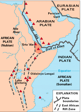 At the southern end lies the strait of Bab-el-Mandeb, considered by a few researchers as the location of the Pillars of Herakles.
Pliny the Elder refers to ‘Pillars’ at the end of the Red Sea and then, without pause, inexplicably mentions, Mauritania, Mt. Atlas and Cerne and shortly afterward to an island known as Atlantis!(c)
>The Red Sea has entered the Atlantis debate mainly because the biblical Exodus has been linked with the 2nd millennium BC eruption of Thera and in turn to the Minoan Hypothesis. Unfortunately, a variety of dates are on offer for the time of the Exodus, which failed to help us pinpoint the date of the eruption or enable the Minoan Hypothesis to provide a definitive date for the destruction of Atlantis.<
>For many the Red Sea is associated with the biblical Exodus. However, the term used to describe it in the Hebrew text is ‘yam suph’, which does not mean Red Sea but ‘Sea of Reeds’ that left generations of bible students looking in the wrong place for evidence of the Exodus. Even the ‘Sea of Reeds’ explanation has been disputed in a paper by Bernard F. Batto on the Biblical Archaeology website(h). Consequently, researchers have turned their attention to other possible location.
One example is a paper offered by Gary Byers who concluded that today’s Ballah Lake in the northeast Nile is the Exodus crossing point! However, the search is not over.<
The ‘Red’ is often attributed to the seasonal blooming of a red-coloured bacterium. Some academics think that the cardinal points were ascribed colours, ‘red’ being south! Emilio Spedicato, in his paper(a) on the location of the biblical Ophir, points out that pumice which is normal volcanic ejecta turns blood-red when mixed with seawater. Immediately to the south is the East Africa Rift, home to dozens of volcanoes, which when erupting may have had pumice dust blown towards the Red Sea!
Coincidentally, the presumed cradle of humanity is situated not too far from the Rift volcanoes and has drawn serious claims(b) that they may have had a part to play in the evolution of hominids!
The oldest known map of the Red Sea, referred to as the Nuzi Map has had its origins traced back to 120 years before the Flood of Noah(d)! George & Dana Brown, a father and son team from Florida, refer to the Red Sea as the Edenic Valley, to the east of which, in northwest Saudi Arabia, Cain’s city of Chanoch had lain(e) and also where, according to the Browns, Noah’s Ark landed(f)!
(a) https://2010-q-conference.com/ophir/ophir-27-10-09.pdf
(b) https://www.seeker.com/volcanic-eruptions-led-to-emergence-of-first-humans-2052178636.html
(d) https://www.angelfire.com/fl/BriansHouse/nuzimapdate.html
(e) https://sites.google.com/site/briansestate/redsea/paradise-past
(f) https://www.angelfire.com/fl/BriansHouse/noahsarkeastofeden.html
(h) Red Sea or Reed Sea? – The BAS Library (biblicalarchaeology.org) *
Acholonu-Olumba, Catherine
Catherine Acholonu-Olumba (1951-2014 ) was from Orlu in Nigeria and well  known as a writer(d), researcher and former lecturer on African Cultural and Gender Studies. She was a frequent contributor to the migration-diffusion website(b). In a recent paper(a) she proposed “that ancient West Africans nurtured a high civilization that was an off-shoot of the fall of Atlantis and the migrations of its peoples in search of new lands.” She also maintained that the West African Igbo language was, in earlier times, a global lingus franca.
Some of her ideas seemed like a melange from Blavatsky/Cayce/Daniken as the following excerpt from a video clip(c) demonstrates,
“By 208,000 BC human evolution was interrupted and Adam, a hybrid, was created through the process of genetic engineering. However, our findings reveal that the creation of Adam was a downward climb on the evolutionary ladder, because he lost his divine essence, he became divided, no longer whole, or wholesome. All over Africa and in ancient Egyptian reports, oral and written traditions maintain that homo erectus people were heavenly beings, and possessed mystical powers such as telepathy, levitation, bi-location, that their words could move rocks and mountains and change the course of rivers. Adam lost all that when his right brain was shut down by those who made him.”
Another paper by Acholonu once again endeavours to link the Igbo language with that of the ancient Egyptians(e).
Even more intriguing is the claim of an association between Ogham and the Igbo language. Erich Fred Legner noted that “All the words that (Edo)Nyland and (Barry)Fell transcribed were Igbo words, which Dr Catherine Acholonu could easily read and translate. She told Edo Nyland that she had translated the words he transcribed from Ogam stones, but he didn’t believe her at first. When Hugo Kennes found Dr Acholonu’s work on the Internet and started telling all the Ogam researchers he knew including Nyland, Nyland then asked him to get an Igbo dictionary from her. It was only after her meeting with (Christine)Pellech in Belgium when she “read “all Acholonu’s books and convinced her to write for her site, that it was decided to do the “Igbo Ogam VCV Dictionary”(g)
Acholonu was one of the authors of They Lived Before Adam: Pre-Historic Origins of the Igbo[1134] which includes some rather wild Igbo-centric claims.
A few years later, she published Eden in Sumer On The Niger [1833], which continued in a similar vein. According to an abstract on ResearchGate,(f) “It provides multidisciplinary evidence of the actual geographical location in West Africa of the Garden of Eden, Atlantis and the original homeland of the Sumerian people before their migration to the “Middle East”. By translating hitherto unknown pre-cuneiform inscriptions of the Sumerians, Catherine Acholonu and Sidney Davis have uncovered thousands of years of Africa’s lost pre-history and evidences of the West African origins of the earliest Pharaohs and Kings of Egypt and Sumer such as Menes and Sargon the Great.”
>In 2017, Michelle Lopez Wellansky presented a paper in which she investigated the Igbo people, the majority of whom “today are practicing Christians. Though they identify as Christian, many consider themselves to be “cultural” or “ethnic” Jews.”(h)
John Boze has contributed a series of unconventional posts on Facebook promoting the idea of a West African Genesis including the claim that “Noah, Abraham and Moses were all born, lived and died in West Africa! Not unexpectedly, Boze also claims that Atlantis was situated in Mauritania. For good measure he further claims that the ten Hebrew nations lived in West Africa 4000BC-3000BC! I think comment is unnecessary.<
(a) https://www.migration-diffusion.info/article.php?id=218
(b) https://www.migration-diffusion.info/article.php?authorid=98
(c) https://igboacienthistory.weebly.com/igbo-language-a-former-global-lingua-franca.html
(d) https://en.wikipedia.org/wiki/Catherine_Obianuju_Acholonu
(f) (PDF) Eden In Sumer On The Niger (researchgate.net)
(g) <Ogam (Ogham) Writing System & Ogam Alphabet (ucr.edu)
(h) https://kulanu.org/wp-content/uploads/nigeria/Igbo-Jews-Senior-Project.pdf *
Syrtis
Syrtis was the name given by the Romans to two gulfs off the North African coast; Syrtis Major which is now known as the Gulf of Sidra off Libya and Syrtis Minor, known today as the Gulf of Gabes in Tunisian waters. They are both shallow sandy gulfs that have been feared from ancient times by mariners. In the Acts of the Apostles (Acts 27.13-18) it is described how St. Paul on his way to Rome was blown off course and feared that they would run aground on ‘Syrtis sands.’
However, they were shipwrecked on Malta or as some claim on Mljet in the Adriatic.
The earliest modern reference to these gulfs that I can find in connection with Atlantis was by Nicolas Fréret in the 18th century when he proposed that Atlantis may have been situated in Syrtis Major. Giorgio Grongnet de Vasse expressed a similar view around the same time. Since then there has been little support for the idea until recent times when Winfried Huf designated Syrtis Major as one of his five divisions of the Atlantean Empire.
However, the region around the Gulf of Gabes has been more persistently associated with aspects of the Atlantis story. Inland from Gabes are the chotts, which were at one time connected to the Mediterranean and considered to have been part of the legendary Lake Tritonis, sometimes suggested as the actual location of Atlantis.
In the Gulf itself, Apollonius of Rhodes placed the Pillars of Herakles(a) , while Anton Mifsud has drawn attention[0209] to the writings of the Greek author, Palefatus of Paros, who stated (c. 32) that the Columns of Heracles were located close to the island of Kerkennah at the western end of Syrtis Minor. Lucanus, the Latin poet, located the Strait of Heracles in Syrtis Minor. Mifsud has pointed out that this reference has been omitted from modern translations of Lucanus’ work!
Férréol Butavand was one of the first modern commentators to locate Atlantis in the Gulf of Gabés[0205]. In 1929 Dr. Paul Borchardt, the German geographer, claimed to have located Atlantis between the chotts and the Gulf, while more recently Alberto Arecchi placed Atlantis in the Gulf when sea levels were lower(b) . George Sarantitis places the ‘Pillars’ near Gabes and Atlantis itself inland, further west in Mauritania, south of the Atlas Mountains. Antonio Usai also places the ‘Pillars’ in the Gulf of Gabes.
In 2018, Charles A. Rogers published a paper(c) on the academia.edu website in which he identified Tunisia as Atlantis with it capital located at the mouth of the Triton River on the Gulf of Gabes. He favours Plato’s 9.000 ‘years’ to have been lunar cycles, bringing the destruction of Atlantis into the middle of the second millennium BC and coinciding with the eruption of Thera which created a tsunami that ran across the Mediterranean destroying the city with the run-up and its subsequent backwash. This partly agrees with my conclusions in Joining the Dots!
Also See: Gulf of Gabes and Tunisia
(a) Argonautica Book IV ii 1230
(c) https://www.academia.edu/36855091/Atlantis_Once_Lost_Now_Found?auto=download*
Richat Structure, The
The Richat Structure or Guelb er Richat in Mauritania” is regarded by geologists as a highly symmetrical and deeply eroded geologic dome. It was first described in the 1930s to 1940s, as Richât Crater or Richât buttonhole. Richard-Molard (1948) considered it to be the result of a laccolithic thrust. A geological expedition to Mauritania led by Théodore Monod in 1952 recorded four ‘crateriform or circular irregularities” in the area.”(q)
The feature was thought by 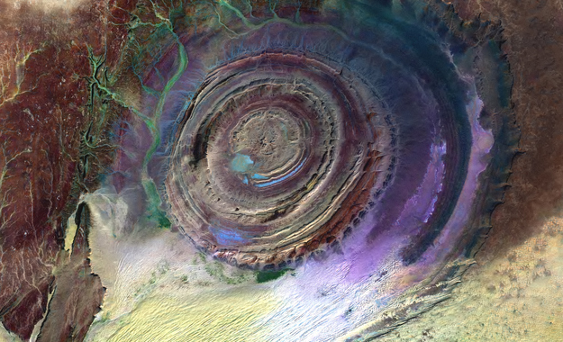 many to be an impact crater until it was identified as the remains of a possible ‘salt dome’(a). Some of the more enthusiastic supporters of the ‘Electric Universe’ school of thought have sought to identify the feature as the consequence of an electrical discharge.(e)
This is outlined in an April 2022 paper by Andrew Hall, explaining what he calls the ‘Keystone Pattern’.(r)
Even creationists have claimed that the original surface of the ‘Structure’ had been eroded by Noah’s Flood(t).
The concentric circles of which the structure is composed is clearly revealed by satellite imagery. However, these characteristics are not visible when walking across the structure(u). The scientific consensus today is that the structure is a natural geological feature. In more technical terms a geological ‘dome’ is “A structure that plunges in all directions to form a circular or elongate structure is a dome. Domes are generally formed from one main deformation event, or via diapirism from underlying magmatic intrusions or movements of upwardly mobile, mechanically ductile material such as rock salt (salt dome) and shale (shale diapir). The Richat Structure of the Sahara is considered a dome that has been laid bare by erosion.”(k) Further geological data was available on a German website(v).
It did not take long before it was compared to Plato’s description of Atlantis. However, Ulf Richter has pointed out that it is too wide (35 km), too elevated (400 metres) and too far from the sea (500 km) to be seriously considered the location of Atlantis. Nevertheless, researchers such as Robert deMelo are still prepared to consider it a possible location candidate(b).
50 km west-southwest of Richat is a similar though smaller feature, the Semsiyat Dome, having a diameter of just 5 km(o).
In 2008, George Sarantitis put forward the idea that the Richat Structure was the location of Atlantis, supporting his contention with an intensive reappraisal of the translation of Plato’s text(g). His theory has been published in Greek[1470], with an English translation now (2017) imminent.
In 2006 George S. Alexander and Natalis Rosen were struck by the similarity of the Richat feature with Plato’s description and decided to investigate on the ground. Instability in the region prevented this until late 2008 when they visited the site, gathering material for a movie. The film was then finalised and published on their then-newly-established website in 2010(c).
In 2008, Charles Giuliani self-published Alternative View of The Distant Past [1969]. In this wide-ranging book, the author tackles the story of Atlantis and endeavours to identify the Richat Structure as the location of Plato’s city of Atlantis. His speculations lack scientific evidence and contradict reason. The main weaknesses are his dating of Atlantis (9600 BC) and the logistical problems of launching an attack on Athens 4,000km away from Richat at a time when archaeology indicates that seafaring was carried out with little more than dugout canoes or rafts.
In 2013 further support for linking Atlantis with Richat came from Jose D.C. Hernandez with a rather convoluted theory in a paper entitled A Celestial Impact and Atlantis(f).
Even more bizarre is the claim by Anthony Woods that although Ireland was the island of Atlantis, the city of Atlantis (Cerne) was in Mauritania and is known today as the Richat Structure!
Towards the end of the 2018 media ‘silly season’, the YouTube channel Bright Insight made a pathetic attempt to breathe new life into the Atlantis in Sahara theory. However, it fails on one simple fact; it is not submerged, but for good measure, when Alexander and Rosen investigated the Richat Structure they could not produce a single piece of physical evidence from the 35 km wide site. Where was the bustling port described by Plato? I could go on, but remember, it’s not called the silly season without reason.
Early November 2018 saw the British tabloid press give further coverage to Jimmy Corsetti’s ideas(i)(j) (The Sun gave his name as Jimmy Bright!). His theories are totally dependent on the destruction of Atlantis having occurred around twelve thousand years ago. He does not explain how an attack was launched from Mauritania on Athens which did not even exist at that time. Corsetti, like many others, needs this very early date to explain why the Richat Structure is not underwater today but was gradually uplifted as a result of tectonic forces in the region. However, Plato clearly states that the submerged Atlantis was still a hazard to shipping in his day, a period when the Structure would have been at its present elevation. As no geologic event has occurred during the two and a half millennia since Plato, which could have raised the Structure from the seabed to an elevation of 400 metres 500 km from the Atlantic, we are obliged to give greater credence to the scientific conclusion that the Richat Structure is a natural feature. Corsetti does have at least one fan(n).
It was in 2018 that Corsetti published a video promoting the Richat Structure as Atlantis, which received extensive coverage. Steven Novella, a well-known Atlantis sceptic, published an article debunking Corsetti’s ‘evidence’ in some considerable detail(s). However, while I would endorse Novella’s arguments(l) regarding the Richat Structure, I strongly disagree with Novella’s closed-minded attitude towards the existence of Atlantis as well as Corsetti’s attention-seeking location choice for Plato’s island. I would add that Corsetti has his date wrong and that to launch an attack on Athens nearly 4000 km away by land (3000 km by sea) from the ‘Structure’ is logistical nonsense.
In a recent conversation with Joe Rogan, Corsetti claimed that since the Structure contains salt, it MUST have been submerged and no other explanation is possible. However, as I have pointed out above the Richat feature is an eroded ‘salt dome’ and quite naturally has salt in it without the need for submersion.
>The natural geological origins of the Richat Structure are discussed in some detail in a 2005 paper by three Canadian scientists in the journal Geology, produced by the Geological Society of America. It would be interesting to hear the response of Corsetti to facts compared with his daft speculations(w).<
However, in 2018, Martin K. Ettington published a booklet entitled The Real Atlantis [1641] in which he also insisted that the Richat Structure is the remains of Atlantis but with no real evidence to support his contention.
In Joining the Dots [1590] and in Atlantipedia.ie I have consistently argued that in ancient times, proximity is an essential logistical requirement in order to achieve a successful invasion. This was particularly true in ancient times when all empires expanded through the invasion of neighbouring territories. The Richat Structure is many thousands of kilometres from Athens, so to suggest that an attack was launched from Mauretania on Greece is simply ludicrous.
There is a relatively recent website(m) dedicated to promoting the ‘Structure’ as the location of Atlantis. It is well presented by its author Gergely (Gregory) Dzsida with plenty of content. Unfortunately, I cannot accept its basic claim, To my mind, it fails to answer Richter’s arguments regarding, size, elevation and location as well as my point regarding proximity.
Not unexpectedly, Jason Colavito has a few thoughts to add to this latest Atlantis in Sahara kerfuffle(h).
Although the Richat Structure as the location of Atlantis conflicts with details in Plato’s account as well as reason, it still gathers supporters based simply on its circular shape. A recent example of this came from a Danish commentator, Palle A. Anderson(p).
An even more ridiculous suggestion was offered in 2021 by Carlos Bisceglia in Atlantis 2021- Lost Continent Rediscovered in which he proposed that Atlantis was known to the Egyptians as the ‘Land of Ma’ and that its capital was the Richat Structure together with the Semsiat Dome, mentioned above, which is 50km away. In order to explain how his Atlantis is not submerged, Bisceglia has proposed that the Land of Ma became confused with the submerged Land of Mu (Sundaland) in the Pacific and that “it is possible that Solon or Plato confused ‘the Land of Ma’ with the ‘Land of Mu’, and thus two completely independent accounts were merged into one.” He adds “how the Egyptian priests knew this is a mystery. Evidently, some survivors from Sundaland arrived in some way in Egypt”
In April 2022, David Edward published Atlantis Solved: The Final Definitive Proof [1926], which also endorsed the Richat Structure as the location of Atlantis. The author of this slender 99-page book admits to being greatly influenced by the earlier claims of Jimmy Corsetti.
(a) https://web.archive.org/web/20160326200714/https://www.atlantis-schoppe.de/richter.pdf
(b) http://www.gpofr.com/documents/2012Atlantis.pdf
(c) Visiting Atlantis | Gateway to a lost world (archive.org)
(e) https://www.thunderbolts.info/tpod/2005/arch05/050407richat.htm
(f) https://blog.world-mysteries.com/science/a-celestial-impact-and-atlantis/
(g) The System of Wheels – Plato Project (archive.org)
(h) https://www.jasoncolavito.com/blog/youtube-video-claims-atlantis-is-located-in-the-sahara-desert
(i) https://www.thesun.co.uk/news/7681682/atlantis-sahara-desert-conspiracy/
(l) https://theness.com/neurologicablog/index.php/no-atlantis-has-not-been-discovered-in-north-africa/
(m) Learn from Ancient Civilizations | Find Atlantis Together (archive.org)
(o) http://www.b14643.de/Mauritania-Craters/index.htm (see the end of page)
(p) The Real Atlantis – where is it? (planker.dk)
(q) Richat Structure – Wikipedia
(r) The Keystone Pattern – The Thunderbolts Project™
(s) https://theness.com/neurologicablog/index.php/no-atlantis-has-not-been-discovered-in-north-africa/
(t) https://creation.com/eye-of-the-sahara
Bryant, Jacob
 Jacob Bryant (1715-1804) was an English antiquarian and mythologist, who completely denied that the Homeric account of the Trojan War had any historical value. This infuriated the Romantic poet Lord George Byron, who denounced Bryant as a ‘blackguard’. All this took place decades before Schliemann began excavating at Hissarlik.
>Eberhard Zangger invoked [483.115] the work of Bryant to support his identification of Troy as Atlantis where Bryant refers to Dardanus as the founder of Ilium or Troy and declares the Dardanians to be Atlantians.<
Although Bryant denied the reality of Troy, he was content to declare that the ‘Atlantians’ were descended from Ham, one of Noah’s sons and that they settled in Phrygia (part of modern Turkey) and Mauritania (North-West Africa). These comments can be found in one of his best known works, New System Or an Analysis of Ancient Mythology (1774 ed. Vol.1 p.387), which can now be read online[1033].
Sahara Desert
The Sahara Desert and in particular its northern regions have attracted its share of attention from Atlantis investigators. However unlikely it may appear as a possible location for Atlantis it must be kept in mind that the Sahara of prehistory was very different from what we see today. Not only was it wetter at various periods in the past, but also there is clear evidence for the existence of a large inland sea extending across the borders of modern Algeria and Tunisia. This evidence is in the form of the chotts or salt flats in both countries. This proposed sea is considered by some to have been the Lake Tritonis referred to by classical writers. It is suggested that some form of tectonic/seismic activity, common in the region, was responsible for isolating this body of seawater from the Mediterranean and eventually turning it into the salt flats we see today.
An even more extensive inland sea, further south, was proposed by Ali Bey el Abbassi and based on his theory a map was published in 1802 which can be viewed online(c).
More recently, Riaan Booysen has published an illustrated paper on the ancient inland Saharan seas as indicated on the 16th-century maps of Mercator and Ortelius(i). King’s College London runs The Sahara Megalakes Project which studies the Megalakes and the Saharan Palaeoclimate record(m).
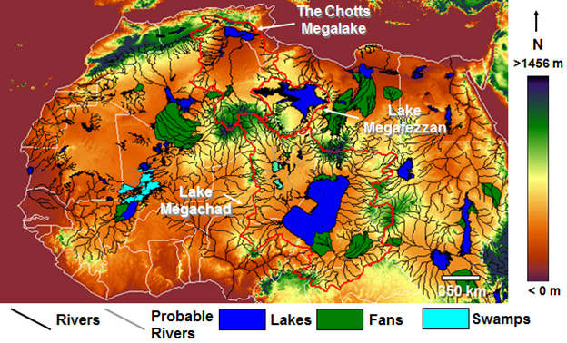
A 2013 report in New Scientist magazine(d) revealed that 100,000 years ago the Sahara had been home to three large rivers that flowed northward, which probably provided migration routes for our ancestors. Depending on how long the African Humid Period lasted, this article may be read in conjunction with George Sarantitis‘ theory regarding the Voyage of Hanno that he claims took place in the interior of Africa.
Other studies(h) have shown the previous existence of a huge river system in the Western Sahara, which flowed into the Atlantic on the Mauritanian coast.
An article in the Sept. 2008 edition of National Geographic pointed out that the Saharan climate has been similar for the past 70,000 years except for a period beginning 12,000 years ago when a number of factors combined to alter this fact. A northerly shift by seasonal monsoons brought additional rain to an area the size of the contiguous USA. This period of a greener Sahara lasted until around 4,500 years ago.
More recent studies claim that “there’s geologic evidence from ocean sediments that these orbitally-paced Green Sahara events occur as far back as the Miocene epoch (23 million to 5 million years ago), including during periods when atmospheric carbon dioxide was similar to and possibly higher than today’s levels. So, a future Green Sahara event is still highly likely in the distant future.” (p)
Henri Lhote contributed an article to Reader’s Digest‘s, The World’s Last Mysteries [1083], regarding the ‘green’ Sahara that existed prior to 2500 BC. Two German climatologists Rudolph Kuper and Stefan Kröpelin have estimated that this last greening of the Sahara began around 8500 BC and ended sometime between 3500 BC and 1500 BC(r)(u)* .
Some have suggested a connection between the latest aridification of the Sahara and the migration of settlers to the Nile Valley, where, coincidentally, the ancient Egypt we know about was founded around 3100 BC.
Others have endeavoured to link the last aridification of the Sahara with the destruction of Atlantis!
More recently, human activity has been blamed as a major contributory factor for the desertification of the Sahara region less than 10,000 years ago.(n)
Related to the above is a recent study of sediments off the west coast of Africa, which resulted in the discovery of what was “primarily a new “beat,” in which the Sahara vacillated between wet and dry climates every 20,000 years, in sync with the region’s monsoon activity and the periodic tilting of the Earth.” (o)
In Mauritania, a huge natural feature known as the Richat Structure has been claimed as the remnant of Atlantis by George Sarantitis [1470] as well as by Alexander & Rosen and others.
In 1868, it was proposed by D.A. Godron, the French botanist, that the Sahara was the location of Atlantis. In 2003, the non-existent archaeologist Dr.Carla Sage announced that she was hoping to lead an international expedition to the Sahara in search of Atlantis. Her contention was that “Atlantis was the capital of a vast North African empire with ports on the Gulf of Sidra”. This report is now confirmed to have been a hoax! I am indebted to Stel Pavlou for uncovering the origin of this story(e).
The idea of an African Atlantis was highlighted in 2021 with the publication of Atletenu [1821], in which the author, Diego Ratti, identified the Hyksos as Atlanteans with their capital at Avaris in the eastern Nile Delta. At the other end of North Africa, the chotts of Tunisia and Algeria were nominated by Holden Zhang as the location of Atlantis in a YouTube clip(q).
Gary Gilligan, the well-known catastrophist, wrote a thought-provoking article(k) on the origin of the Saharan sands, which he claims are extraterrestrial in origin and expands on the idea in his 2016 book Extraterrestrial Sands [1365].>A March 2024 report(t). on the BBC website has revealed that a particular type of sand dune has now been dated. They are known as ‘star’ or ‘pyramid’ dunes – “are named after their distinctive shapes and reach hundreds of metres in height.” They are found in Africa, Asia and North America, as well as on Mars – but experts had never before been able to put a date on when they were formed. Now scientists have discovered that a dune called Lala Lallia in Morocco formed 13,000 years ago.”<
David Mattingly, an archaeologist at Leicester University has found that an ancient people known as the Garamantes had an extensive civilisation in the Sahara(l). He has evidence of at least three cities and twenty other settlements. The Garamantes reached their peak around 100 BC and then gradually diminished in influence as fossil water supplies reduced until in the 7th century AD they were subjected to Islamic domination. Some researchers such as Frank Joseph have identified the Garamantes as being linked with the Sea Peoples. Bob Idjennaden has published short but informative Kindle books about both the Garamantes [1194] and the Sea Peoples [1195], without a suggestion of any connection between the two.
The discovery of megalithic structures discovered at Nabta Playa (Nabta Lake) in the Egyptian Sahara has provided evidence for the existence of a sophisticated society in that area around 5000 BC. In the same region, near the Dakhleh Oasis, archaeologists have produced data that supports the idea that pre-Pharaonic Egypt had Desert Origins rather than being an importation from Mesopotamia or elsewhere(a).
Nabta Playa is not unique, in fact, the largest megalithic ellipse in the world is to be found at Mzorah, 27 km from Lixus in Morocco(b). It appears that the construction methods employed at both Mezorah and Nabta Playa are both similar to that used in the British Isles. An even more impressive site is Adam’s Calendar in South Africa which has been claimed as 75,000-250,000 years old.
West of Cairo near the border with Libya is the Siwa Oasis, where it has now been demonstrated that “it is in fact home to one of Ancient Egypt’s astounding solar-calendar technologies– the solar equinox alignment between the Timasirayn Temple and the Temple of Amun Oracle in Aghurmi.”(j).
I think we can expect further exciting discoveries in the Sahara leading to a clearer picture of the prehistoric cultures of the region and what connections there are, if any, with Plato’s Atlantis. In the meanwhile in the Eastern Egyptian Desert, Douglas Brewer, a professor of archaeology at the University of Illinois, has discovered over 1,000 examples of rock art, including numerous depictions of boats although the sites, so far undisclosed, are remote from water.
Even more remarkable is the report(e) of March 2015 that a survey of the Messak Settafet escarpment in the central Sahara revealed that there were enough discarded stone tools in the region “to build more than one Great Pyramid for every square kilometre of land on the continent”! Coincidentally, around the same time, it was reported that over a thousand stone tools had been found in the Northern Utah Desert(g). What the Utah discovery lacked in quantity was made up for in quality with the finding of the largest known Haskett point spearhead, measuring around nine inches in length.
(a) Saudi Aramco World (2006, Vol. 57, No.5 p.2-11)
(c) https://web.archive.org/web/20201019061756/http://catalog.afriterra.org/zoomMap.cmd?number=1036
(d) NewScientist.com, 16 September 2013, https://tinyurl.com/mg9vcoz
(e) https://books.google.com/books?id=GvMDAAAAMBAJ&pg=PA46&dq=dr.+carla+sage+archaeologist&hl=en&sa=X&ei=GSENVKiaO9W0yASJgoIY&ved=0CCYQ6AEwAA#v=onepage&q=dr.%20carla%20sage%20archaeologist&f=false
(f) https://www.cam.ac.uk/research/news/saharan-carpet-of-tools-is-the-earliest-known-man-made-landscape
(i) 7. The lakes in the middle of the Sahara desert – Page 8 (archive.org)
(l) See: Archive 3268
(n) https://popular-archaeology.com/issue/winter-2017/article/did-humans-create-the-sahara-desert
(o) https://phys.org/news/2019-01-sahara-swung-lush-conditions-years.html#jCp
(p) https://www.livescience.com/will-sahara-desert-turn-green.html
(q) Revive Eden 3 Convincing Atlantis – YouTube
(r) https://www.smithsonianmag.com/history/uncovering-secrets-of-the-sphinx-5053442/
(s) https://las.illinois.edu/news/2006-09-01/oasis-art-egyptian-desert *
(t) Star dune: Scientists solve mystery behind Earth’s largest desert sands – BBC News *
(u) Shift From Savannah to Sahara Was Gradual, Research Suggests – The New York Times (nytimes.com) *