Latest News

Joining The Dots
I have now published my new book, Joining The Dots, which offers a fresh look at the Atlantis mystery. I have addressed the critical questions of when, where and who, using Plato’s own words, tempered with some critical thinking and a modicum of common sense.Read More »
Strait of Messina
Landbridges
Landbridges, in biogeography are described by Wikipedia as “an isthmus or wider land connection between otherwise separate areas, over which animals and plants are able to cross and colonize new lands. A land bridge can be created by marine regression, in which sea levels fall, exposing shallow, previously submerged sections of continental shelf; or when new land is created by plate tectonics; or occasionally when the sea floor rises due to post-glacial rebound after an ice age.”
In the distant past, landbridges are believed to have played a critical part in early human migration. Similarly, 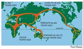 landbridges, both real and speculative, are important components in many Atlantis theories. There is no doubt that the ending of the last Ice Age and the consequent rising sea levels led to the creation of islands where continuous land had previously existed. The separation of Ireland and Britain from each other and from mainland Europe is just one example, the latter leading to a number of writers identifying ‘Doggerland‘, which lay between Britain and Denmark, as the home of Atlantis.
The two most discussed landbridges were at the Bering Strait, where it is thought that it provided the gateway for humans to enter the Americas from Asia and an Atlantic landbridge, which was proposed as early as the 17th century when Francois Placet, a French abbot, who, in 1668, wrote “The break up of large and small world’s, as being demonstrated that America was connected before the flood with the other parts of the world.” A Scientific American article relates how “He argued that the two continents were once connected by the lost continent of “Atlantis” and the flood of the bible separated them.” (d)
Later, by John B. Newman in 1849 [488.8], wrote that “in former times an island of enormous dimensions, named Atlantis, stretched from the north-western coast of Africa across the Atlantic ocean and that over this continental tract both man and beast migrated westward.“
Charles Frédéric Martins was a French botanist and geologist who was so intrigued by the similarity of geology as well as plant species on the Azores, Spain and Ireland that he suggested in his 1866 book, Du Spitzberg Au Sahara [1440],that these were physically linked in the distant past and that they may have been part of Atlantis(c).
Martins also said, in the Revue des Deux Mondes for March 1, 1867, “Now, hydrography, geology, and botany agree in teaching us that the Azores, the Canaries, and Madeira are the remains of a great continent which formerly united Europe to North America.”
The Atlantic landbridge idea became quite popular by the end of the 19th and beginning of the 20th centuries and even as late as the 1970s when espoused by Rene Malaise(a), but is now completely abandoned. Ignatius Donnelly referred to such a landbridge as a ‘connecting plateau’ linking Europe, Africa and America that allowed plants and animals to cross in both directions.
Although there was only one suggestion that the Bering Strait was in any way connected with Plato’s Atlantis, several commentators identified an Atlantic landbridge as the ideal location for Plato’s Atlantis, particularly as he placed it in the Atlantic Sea. However, this should not be confused with the Atlantic Ocean, a word that had an entirely different meaning for the ancient Greeks.
The idea was initially put forward in order to explain the floral and faunal similarities shared by the Old World and the New World of the Americas. The hypothetical Atlantic landbridges or a series of stepping stone islands also offered possible routes for the peopling of the Americas by Europeans and/or Africans. It was not long before the discovery of the Mid-Atlantic Ridge(b) seemed to confirm this idea. Then it was suggested that Atlantis existed on this landbridge, which was destroyed by rising sea levels after the last Ice Age, leaving just the Azores, Madeira and a few other islands as remnants.
Several landbridges have been proposed for the Mediterranean and linked to a variety of Atlantis theories, the most notable being proposed for the straits of Gibraltar, Sicily, Messina and Bonifacio. Although it is evident that landbridges existed at most of these locations, to associate them with any particular Atlantis theory requires that the date of their existence is compatible with Plato’s narrative.
Less popular theories have been constructed involving landbridges in locations such as the Caribbean and Indonesia.
(a) Atlantis, Vol.27, No.1, Jan-Feb 1974.
(b) From the Contracting Earth to early Supercontinents – Scientific American Blog Network
Italy
Italy seems to have an uncertain etymology; Thucydides claims that Italos, the Sicilian king gave his name to Italy, while more recently Emilio Spedicato(h) considers that ”the best derivation we believe to be the one proposed by the Italian nuclear engineer Felice Vinci (1998), in his monograph claiming a Baltic setting for the Homeric epic: he derives Italia from the rare Greek word aithalia, meaning the smoking one.” This is thought to be a reference to Italy’s many volcanoes.
Italy today is comprised of territory south of the Alps on mainland Europe including a very large boot-shaped peninsula, plus Sicily, Sardinia and some smaller island groups, which along with the French island of Corsica virtually enclose the Tyrrhenian Sea.
The earliest proposal that Italy could be linked with Atlantis came from Angelo Mazzoldi in 1840, when he claimed that before Etruria, Italy had been home to Atlantis and dated its demise to 1986 BC. Mazzoldi expressed a form of hyperdiffusion that had his Italian Atlantis as the mother culture which seeded the great civilisations of the eastern Mediterranean region(b).
Some of Mazzoldi’s views regarding ancient Italy were expanded on by later scholars such as Camillo Ravioli, Ciro Nispi-Landi, Evelino Leonardi, Costantine Cattoi, Guido DiNardo and Giuseppe Brex. Ravioli sought to associate the Maltese island of Gozo with his proposed Atlantis in Italy.
The Italian region of Lazio, which includes Rome, has had a number of very ancient structures proposed as Atlantean; Monte Circeo (Leonardi) and Arpino(a) (Cassaro). Another aspect of Italian prehistory is the story of Tirrenide, which was described as a westward extension of the Italian landmass into the Tyrrhenian Sea during the last Ice Age, with a land bridge to a conjoined Sardinia and Corsica. At the same time, there were land links to Sicily and Malta, which were all destroyed as deglaciation took place and sea levels rose.
 It is surprising that so few researchers have commented on Italy’s part in Plato’s Atlantis narrative considering that he twice, without any ambiguity, informs us that the Atlantean domain extended as far as Tyrrhenia (modern Tuscany).
Crit.114c. So all these, themselves and their descendants dwelt for many generations bearing rule over many other islands throughout the sea and holding sway besides, as was previously stated, over the Mediterranean peoples as far as Egypt and Tuscany. Tim.25a/b. Now in this island of Atlantis there existed a confederation of kings, of great and marvellous power, which held sway over all the island, and over many other islands also and parts of the continent; and, moreover, of the lands here within the Straits they ruled over Libya as far as Egypt, and over Europe as far as Tuscany. (Bury)
The quotation from Timaeus is most interesting because of its reference to a ‘continent’. Some have understandably but incorrectly claimed that this is a reference to America or Antarctica, when quite clearly it refers to southern Italy as part of the continent of Europe. Moreover, Herodotus is quite clear (4.42) that the ancient Greeks knew of only three continents, Europe, Asia and Libya.
Philo of Alexandria (20 BC-50 AD) in his On the Eternity of the World(g) wrote “Are you ignorant of the celebrated account which is given of that most sacred Sicilian strait, which in old times joined Sicily to the continent of Italy?” (v.139). The name ‘Italy’ was normally used until the third century BC to describe just the southern part of the peninsula(e). Some commentators think that Philo was quoting Theophrastus, Aristotle’s successor. This would push the custom of referring to Italy as a ‘continent’ back near to the time of Plato. More recently, Armin Wolf, the German historian, when writing about Scheria relates(f) that “Even today, when people from Sicily go to Calabria (southern Italy) they say they are going to the ‘continente’.” This continuing usage is further confirmed by a current travel site(d) and by author, Robert Fox[1168.141]. I suggest that Plato used the term in a similar fashion and can be seen as offering the most rational explanation for the use of the word ‘continent’ in Timaeus 25a.
When you consider that close to Italy are located the large islands of Sicily, Sardinia and Corsica, as well as smaller archipelagos such as the Egadi, Lipari and Maltese groups, the idea of Atlantis in the Central Mediterranean can be seen as highly compatible with Plato’s description.
If we accept Plato stated unambiguously that the domain of Atlantis included at least part of southern Italy and also declared Atlantis attacked from beyond the Pillars of Heracles, then this appellation could not be applied at that time to any location in the vicinity of the Strait of Gibraltar but must have been further east, probably not too far from Atlantean Italy. This matches earlier alternative locations recorded by classical writers who placed the ‘Pillars’ at the straits of Messina or Sicily. I personally favour Messina, unless there is stronger evidence that some of the islands in or near the Strait of Sicily, such as the Maltese or Pelagian Islands, or Pantelleria, were home to the ‘Pillars’.
(a) http://www.richardcassaro.com/hidden-italy-the-forbidden-cyclopean-ruins-of-giants-from-atlantis
(b) http://web.archive.org/web/20211202122517/https://atlantipedia.ie/samples/archive-2509/ (Eng),
http://web.archive.org/web/20211021081119/https://atlantipedia.ie/samples/archive-2943/ (Ital)
(c) http://web.archive.org/web/20200215123300/https://atlantipedia.ie/samples/archive-2946/
(d) Four Ways to Do Sicily – Articles – Departures (archive.org)
(e) https://profilbaru.com/article/Name_of_Italy
(f) Wayback Machine (archive.org)
(g) http://www.earlychristianwritings.com/yonge/book35.html
(h) http://2010-q-conference.com/ophir/ophir-27-10-09.pdf
Invasion
Invasion today, as in the past, is usually the consequence of a shortage of resources (food, metals, oil, water), climate change (affecting food supply), overpopulation (also affecting food supply) or political upheaval. Although I do not speak as a military strategist, it would seem obvious that if for any of these reasons, a state is forced into expansionism, it will first look at its nearest neighbours and assess the chances of military success. It is obvious that before the introduction of airborne attacks, propinquity in the form of contiguous territory or short sea journeys has always been critical for a successful invasion(a) and the continued control of occupied territories. This is borne out by the simple historical fact that all the earliest empires, which were located in what we now call the Middle East, expanded through the invasion of its neighbours.
Even today (27.02.22) Vladimir Putin has expanded his empire into more of the contiguous state of Ukraine, having already annexed Crimea. Some military imperatives never change.
However, over-expansion can be costly and potentially dangerous. With particular reference to the fall of the Roman Empire, Rachel Nuwer noted in a recent BBC article(c) that. “By the end of the 100 BC, the Romans had spread across the Mediterranean, to the places most easily accessed by sea. They should have stopped there, but things were going well and they felt empowered to expand to new frontiers by land. While transportation by sea was economical, however, transportation across the land was slow and expensive. All the while, they were overextending themselves and running up costs.”
Many people think that military intelligence gathering is a relatively modern development. However, ancient documents, including the Bible, have accounts of spying thousands of years ago. Mary Rose Sheldon has produced an invaluable sourcebook[1445] on the subject, as well as a volume on Spies in the Bible[1446], while Peter Dubovsky, in his Hezekiah and the Assyrian Spies[1568], focuses on espionage described in 2 Kgs 18-19. It is reasonable therefore to assume that Atlantis also exercised due diligence and endeavoured to assess their opponent’s strengths and weaknesses before invading.
Boris Rankov has noted(b) in The Encyclopedia of Ancient History, that military intelligence in ancient times had its value limited by the “slowness of communications, which meant that it was often out of date before any response could be brought to bear.” This, of course, ties in with the then established practice of invading those within your immediate proximity; supply lines are shorter and information more up-to-date. In turn, it implies that Atlantis was within relatively easy striking distance of Athens!
Even in modern times, the same constraints determine the actions of invaders. Hitler could not have invaded Russia without first controlling western Poland, facing Russian-held eastern Poland. Even expansionist Japan, although an island nation, expanded into Korea and Manchuria (China) and following the attack on Pearl Harbour spread even further within the same region.
The ancient land-based empires were dependent on military might, whereas others, such as the Phoenicians, expanded their influence through trade, supported by extensive merchant fleets. However, over time, Phoenician or more correctly, Carthaginian rivalry with Rome, led to disastrous wars.
One of the primary military concerns today, as in ancient times, will be to ensure that its men are fed and watered and consequently there will be a need to keep its supply lines as short as possible.
One of the possible threats that lay to the west of ancient Athens was from across the Adriatic in Italy. However, even closer were a number of possible rivals to the east in Anatolia, such as Lydians and Hittites and later, the Persians.
I argue elsewhere that according to Plato, southern Italy constituted part of the Atlantean domain (see Etruscans). I suggest that the Atlantean invasion of Greece was probably launched from there. The motivation is unclear, but we can speculate that success in Greece would have been followed by the control of the entire Aegean, including Crete, offering a huge expansion in trade.
The alternative is that the nearest part of Atlantis was elsewhere, necessitating the bypassing of other territories on the way and stretching supply and communication lines more than desirable. Italy looks the best bet, with forces added from the Atlantean HQ in Sicily or Sardinia, possibly travelling through the Strait of Messina, sometimes identified as the location of the Pillars of Heracles.
In the south, the Atlantean forces in North Africa (Ancient Libya), if not augmenting the attack on Greece, were probably planning their invasion of Egypt (Timaeus 25b & Critias 114c). Success there would have been followed by a two-pronged attack by both northern and southern Atlantean forces on the eastern Mediterranean coast, later known as the Levant, giving them total control of the eastern Mediterranean Basin.
Invasion requirements are the strongest argument against any of the fanciful Atlantis theories that place Plato’s Atlantis in Antarctica, the Andes, or North America. It is ludicrous to claim that any invasion force came across the Atlantic to attack Greeks and Egyptians. That there were remarkable early cultures in both North and South America is absolutely undeniable, however, it is foolishness to claim that they had any connection with Plato’s story.
(a) https://en.wikipedia.org/wiki/List_of_invasions
(b) http://onlinelibrary.wiley.com/doi/10.1002/9781444338386.wbeah26323/abstract
(c) (BBC April 18, 2017) http://www.bbc.com/future/story/20170418-how-western-civilisation-could-collapse
Tyrrhenian Sea
>The Tyrrhenian Sea according to Massimo Pittau was named after the Sardinian Nuragics, since in ancient Greek ‘Tyrrenoi’ means ‘builders of towers’. As noted elsewhere, Sardinia was an important part of the Atlantean domain.<
Plato clearly states that Atlantis controlled Europe as far as Tyrrhenia (Critias 114c), which implies that they dominated the southern half of the Italian peninsula. The Sea is surrounded by the islands of Corsica, Sardinia, Sicily and the Lipari Islands as well as continental Europe in the form of the Italian mainland. Not only does it contain islands with an adjacent continent (see Timaeus 24e). It is also accessed through the straits of Messina and Sicily, both of which have been identified as locations for the Pillars of Heracles before Eratosthenes applied that appellation to the region of Gibraltar.
Timaeus 24e-25a as translated by Bury reads “there lay an island which was larger than Libya and Asia together; and it was possible for the travellers of that time to cross from it to the other islands, and from the islands to the whole of the continent over against them which encompasses that veritable ocean (pontos=sea). For all that we have here, lying within the mouth of which we speak, is evidently a haven having a narrow entrance; but that yonder is a real ocean (pelagos=sea), and the land surrounding it may most rightly be called, in the fullest and truest sense, a continent.” Similarly, Lee and Jowett have 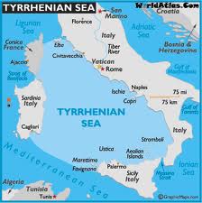 misleadingly translated both pontos and pelagos as ‘ocean’, while the earliest English translation by Thomas Taylor correctly renders them as ‘sea’. Modern translators such as Joseph Warren Wells and a Greek commentator George Sarantitis are both quite happy to agree with Taylor’s translation. However, Peter Kalkavage translates pontos as ‘sea’ but pelagos as ‘ocean’!
For me, there is a very strong case to be made for identifying the Tyrrhenian Sea as the ‘sea’ referred to by Plato in the passage quoted above. However, it was probably F.Butavand, in 1925, who first proposed the Tyrrhenian as the sea described by Plato in his La Veritable Histoire de L’Atlantide[205] .
Pushing the boat out a little further, I note that Rome is situated in Central Italy and by tradition was founded by the twins Romulus and Remus!
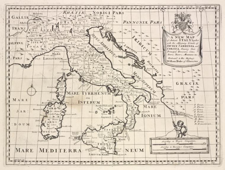
A 1700 map of the Tyrrhenian Sea is available online.
‘Tyrrhenia’ is sometimes used as a geological term to describe a sunken landmass in the Western Mediterranean Basin(b)(c).
(a) (link broken) *
Krupa, Thomas J.
Thomas J. Krupa (1930-2017) is the author of Biblical Flood, Noah’s Ark and the Star of David [1010] , in which he makes a number of startling claims. The book begins with an attack on the theory of plate tectonics. He then moves on to the opening of Drake Passage(a), conventionally considered to have taken place around 40 million years, but dated by Krupa to just 29,000 years ago, eventually leading to the ending of the Ice Age.
He also proposes the existence of an isthmus or landbridge between Sicily and North Africa and that the limestone structure was weakened by the rising Atlantic and rain erosion before being finally fractured by an earthquake, leading to the flooding of the Black Sea and further afield. He then contends that a backwash from this flooding created the Strait of Messina.
He believes that this Sicilian isthmus “is a stronger contender for the location of Atlantis than every other place that I am aware of.”

Kaaba
Krupa then moves on to discuss Noah’s* Ark, which he claims had a keel shaped like the Star of David and furthermore that the ‘Star’ was incorporated in the design of Stonehenge! Coincidentally, Robert John Langdon has also linked the hexagram or Star of David with the layout of Stonehenge(b).
Advancing to even more contentious matters, he maintains that the Kaaba in Mecca is intended as a replica of the Ark and to crown it all that Alexander the Great is buried within the Kaaba!!!
(a) https://en.wikipedia.org/wiki/Drake_Passage
(b) https://robertjohnlangdon.blogspot.co.uk/2014/06/quantum-of-solstice.html (link broken)
Magna Graecia
Magna Graecia is the term applied to those parts of southern Italy and  Sicily colonised by the Greeks, beginning as early as the 8th century BC. An interesting fact is that Philo of Alexandria (20 BC-50 AD) in his On the Eternity of the World(b) wrote: “Are you ignorant of the celebrated account which is given of that most sacred Sicilian strait, which in old times joined Sicily to the continent of Italy?” (v.139). The name ‘Italy’ was normally used in ancient times to describe the southern part of the peninsula(d). Some commentators think that Philo was quoting Theophrastus, Aristotle’s successor. This would push the custom of referring to Italy as a ‘continent’ back to the time of Plato. More recently, Armin Wolf (1935- ), the German historian, when writing about Scheria relates(a) that “Even today, when people from Sicily go to Calabria (southern Italy) they say they are going to the “continente.” This continuing usage is confirmed by a current travel site(c). I suggest that Plato used the term in a similar fashion and can be seen as offering a more rational explanation for the use of the word ‘continent’ in Timaeus 25a, adding to the idea of Atlantis in the Central Mediterranean.
Giuseppe Palermo, in his 2012 book Atlantide degli italiani is now bravely promoting the idea that Plato’s Atlantis was originally located beneath the town of Acri and the surrounding region of Calabria. He supports his claim by matching measurements provided by Plato with physical features around Acri(e). However surprising this idea may seem, it should be pointed out that according to Plato, Atlanteans had occupied southern Italy as far north as Tyrrhenia (Timaeus 25b & Critias 114c). If all this is not true, as a second prize, Acri can at least claim to be the birthplace of the famous American bodybuilder, Charles Atlas!
The Greeks began their gradual expansion westward between the 9th and 6th centuries BC, a development clearly illustrated on an excellent series of online maps(h). Understandably, they would have taken the shortest route from the Greek mainland to the heel of Italy and later on to Sicily. As they progressed with their colonisation, new limits were set, and in time, exceeded. I suggest that these limits were each in turn designated the ‘Pillars of Heracles’ as they expanded. I speculate that Capo Colonna (Cape of the Column) in Calabria may have been one of those boundaries.
Interestingly, 18th-century maps show up to five islands near the cape which are no longer visible(g), suggesting the possibility that in ancient times they could have been even more extensive, creating a strait perhaps matching Plato’s description. On the other hand, the Strait of Messina was one of the locations recorded as the site of the ‘Pillars’. Considering that mariners at that time preferred to hug the coast, I would opt for the Strait of Messina rather than the more frequently proposed Strait of Sicily. A strait is defined as a narrow sea passage, a description that seems inappropriate for the 96 miles separating Sicily from Tunisia.
For a brief history of the rise and fall of Magna Graecia, have a look at the classical wisdom website(f).
It is also noteworthy that there are a number of towns in Calabria where ancient Greek is still spoken(i). Similarly, back on the Peloponnese, the language of Sparta, Tsakonika, is still spoken by about 2,000 people in an area limited to 13 towns, villages and hamlets, located around the village of Pera Melana(j).
(a) Wayback Machine (archive.org)
(b) http://www.earlychristianwritings.com/yonge/book35.html
(c) Four Ways to Do Sicily – Articles – Departures (archive.org)
(d) article Name of Italy (profilbaru.com)
(e) https://www.atlantid.info/?page_id=539
(f) See: https://web.archive.org/web/20180824200049/https://classicalwisdom.com/magna-graecia-greater-greece/
(g) https://www.academia.edu/1152285/Discovery_of_Ancient_Harbour_Structures_in_Calabria_Italy_and_Implications_for_the_Interpretation_of_Nearby_Sites
(h) See: https://web.archive.org/web/20141105204103/https://learningobjects.wesleyan.edu/greek_colonies/
(i) http://www.madeinsouthitalytoday.com/mysterios-places.php
(j) (BBC Dec.16, 2020) BBC – Travel – The last speakers of ancient Sparta
Novo, Diego Silvio
Diego Silvio Novo is an Italian researcher who has joined the ‘Atlantis in Sardinia ’ club(a)(b). He follows the work of Sergio Frau in placing the ‘Pillars of Heracles’ at Strait of Sicily, which he claims was much narrower at the time of Atlantis.
The first link below tells of Novo’s support for Frau but also ends with an angry response from Rosario Vieni, who claims that he had proposed the Strait of Messina as the location of the Pillars of Heracles before Sergio Frau and that his (Vieni’s) work had been plagiarised!
(a) http://web.archive.org/web/20191216233204/https://atlantipedia.ie/samples/archive-2353/ (Italian)
(b) https://web.archive.org/web/20090907222603/https://www.ilportaledelmistero.net/articolo0264.html
Poddighe, Paolo Valente
 Paolo Valente Poddighe is an Italian researcher who claims to have been the first to have identified Sardinia (along with Corsica) as the location of Atlantis as early as 1982. This was long before Robert Ishoy proposed the same on his website(a) and two decades before Sergio Frau published his 2002 book with an identical claim. This led to accusations of plagiarism by Poddighe, who only then published his own book, Atlantide Sardegna: Isola dei Faraoni [0711] (Atlantis Sardinia: Island of the Pharaohs).
Where Frau locates the Pillars of Heracles at the Strait of Sicily, Poddighe opted for the Strait of Bonifacio between Sardinia and Corsica, which would imply that the islands of Atlantis ‘beyond the Pillars’ would have to be the Balearic Islands, which offer few features to match Plato’s description of Atlantis. Consequently, I am personally inclined towards siting them further east, at the Strait of Messina. In which case, it could be reasonably argued that the islands ‘beyond the Pillars’ were Sardinia and Corsica.
Vieni, Rosario *
Rosario Vieni (1941- ) is an Italian Professor of History who was born in Messina, Sicily and currently lives in Pistoia in Northern Italy. He has studied the Phaistos Disk and published a calendrical interpretation of that artefact(e)(f).
 Vieni also presented a paper(a) to the 2005 Atlantis Conference on Melos entitled “11,500 years ago….” He proposes that prior to the ending of the last Ice Age; the Mediterranean was 150-200 metres lower than at present. He also suggests that the Strait of Messina was closed and that a landmass extended south to encompass the Maltese Islands.
Consequently, Vieni opted for a then narrower Strait of Sicily as the location for the Pillars of Heracles and provided strong documentary evidence for this view.
He was greatly annoyed that Sergio Frau has claimed to have been the first to make this assertion a couple of years after he did(g). Which explains why, when Vieni subsequently published his theories in book form in 2011, he entitled it Atlantide e le Colonne d’Ercole (Atlantis and the Pillars of Hercules)[1177].
Although Vieni does not opt for any particular location for Atlantis, the focus of his paper is on the matching of Plato’s description with the Central Mediterranean. The title of his 2005 paper clearly indicates his support for the very early date for Plato’s Atlantis.
Not content with the Atlantis controversy, Vieni ventured into even more heretical territory when he indicated support for the Expanding Earth Hypothesis. James Maxlow, a leading proponent of this theory claims that the concept, sometimes referred to as Earth Expansion Tectonics, explains all existing physical geological data better than Plate Tectonics(b).
Obviously Vieni came to realise that Plato’s mention of 9,000 years could not be taken as a reference to solar years and therefore to suggest that Atlantis was destroyed 11,500 years ago was no longer tenable. Consequently, when he addressed the 2008 Atlantis Conference he revised the title of his paper to “about 5,600 years ago….” in which he offered strong arguments in support of the idea that when Plato wrote of 9,000 years he was referring to ‘seasons’ of which there were three in the Egyptian solar year. This idea is not new having been suggested by the naturalist C. S. Rafinesque in 1836, referring to even earlier sources[896.231]. These included Giovanni Carli who dated Atlantis at 3890 BC.
He also suggests volcanic activity as the probable cause of Atlantis’ demise, pointing to the ongoing volcanic activity in the Central Mediterranean. A website dealing briefly with this region’s volcanology is worth a visit(c) as well as the Wikipedia article on Italian volcanoes(d).
(a) See: Archive 3424
(b) http://www.expansiontectonics.com/page3.html
(c) Category:Volcanoes of the Mediterranean Sea – Wikipedia
(d) http://en.wikipedia.org/wiki/Volcanology_of_Italy
(e) Wayback Machine (archive.org)
(f) ARTICOLO: Il Disco di Festo. Un calendario vecchio di 400… (archive.org) (Italian) *
(g) ARTICOLO: Le colonne d´Ercole un´inchiesta all´inchiesta! (archive.org) (Italian) *
Tyrrhenia
Tyrrhenia was the Greek name for that part of modern Italy formerly occupied by the Etruscans, who were known as Tusci by the Romans, from which we get its current name, Tuscany. Plato twice described (Tim.25B & Crit.114C) Tyrrhenia together with Libya (North Africa), as far as Egypt, providing the northern and southern boundaries of the Atlantean sphere of influence.
>The exact extent of Egyptian-controlled territory in Libya at the time of Atlantis is unclear. We do know that “In the mid-13th century, Marmarica was dominated by an Egyptian fortress chain stretching along the coast as far west as the area around Marsa Matruh; by the early 12th century, Egypt claimed overlordship of Cyrenaican tribes as well. At one point a ruler chosen by Egypt was set up (briefly!) over the combined tribes of Meshwesh, Libu, and Soped.”(e) Another site(d) suggests that Egyptian control stretched nearly as far as Syrtis Major, which has been proposed by some as the location of Atlantis.<
Anton Mifsud points out[209] that the present Maltese Islands were considerably more extensive in prehistoric times and is situated between these two locations adding considerable credence to his claim that the Maltese Islands are probably the remnants of Atlantis. Some ancient maps mark the sea to the west of the Strait of Messina between Sicily and Italy as the ‘Atlantic Ocean’. Furthermore, this strait has also had the title of ‘the Pillars of Heracles’.
One dissenting voice is that of R. McQuillen who is convinced(a) that the Platonic tale refers to another Tyrrhenia, in Turkey, while Taylor Hansen considered the Tyrrhenians to have moved east where they were known as Phoenicians[0572.34]. However, there are persistent claims that the Tyrrhenians did originate in Anatolia with Troy, Lemnos and Lydia being frequently mentioned. There are also counterclaims based on the conflicting account by classical authors(a). The matter remains unresolved.
The Tyrrhenians were also known to the Greeks as Tyrsenians and some have identified them with the Teresh, one of the Sea Peoples(c).
(a) http://gizacalc.freehostia.com/Atlantis.html
(b) Tag – Anatolian origin theory – Someone Was Wrong On The Internet (archive.org)
(c) http://www.ancient-origins.net/myths-legends/identifying-teresh-sea-peoples-001959
(d) https://starshinetours.com/first-signs-of-weakening/ (link broken) *
(e) https://www.penn.museum/sites/expedition/egyptians-and-libyans-in-the-new-kingdom/ *