Latest News

Joining The Dots
I have now published my new book, Joining The Dots, which offers a fresh look at the Atlantis mystery. I have addressed the critical questions of when, where and who, using Plato’s own words, tempered with some critical thinking and a modicum of common sense.Read More »
nuraghi
Taulas
 The Taulas, on the island of Menorca in the Balearics, are one of a number of distinctive types of often enigmatic megalithic structures found on some of the islands of the Central and Western Mediterranean. Along with taulas(a) we have the menhirs of Corsica(b), the nuraghi of Sardinia(c) and the temples of Malta(d). It has been claimed(e) that the Maltese temples were built by ancient Sicilians, a claim which raises an obvious question as to why, if that was the case, no comparable temples were built on Sicily, which does have its own collection of dolmens(f).
A February 2023 BBC article noted that “Menorca has one of the highest concentrations of prehistoric sites in the world (a selection of which are being considered for inclusion in Unesco’s World Heritage list in 2023). If the island is granted World Heritage status this year, it will unlock more funding for much-needed research that may help answer some of the mysteries of the taulas. It would also be a boon for cultural tourism, encouraging new visitors to explore this beautiful island with its unique archaeological heritage.” (l)
Waldemar Fenn, a German archaeologist came to Menorca in the 1930s and began a study of the taulas and spent the rest of his life there. He concluded that the monuments had an astronomical use and that the ancient people of Minorca who created these taulas over 3,500 years ago used them to follow the moon and accurately predicted lunar eclipses(k)!
Peter Hochsieder & Doris Knösel have published[1064] an extensive study of the thirty-one taulas remaining, including an investigation of their possible archaeoastronomical significance. A recent study(g) of Neolithic tombs in Monte Revincu, appears to confirm that these monuments had an astronomical orientation, supporting the opinions of Michael Hoskin(i) as well as those of Hochsieder & Knösel(h).>Other theories can be found on the larazzodeltempo.it website(j).<
Taulas (which means ‘table’ in Catalan) are frequently found near talayots, which are earlier tower-like structures of which there are at least 274 on Majorca and Menorca.
>I have commented elsewhere that the shape of the taulas is remarkably like that of the monuments found at Göbekli Tepe! However, the two sites are not only separated by thousands of kilometers but by many thousands of years!<
(c) https://www.charmingsardinia.com/sardinia/su-nuraxi.html
(d) https://whc.unesco.org/en/list/132
(e) https://www.bestofsicily.com/mag/art294.htm
(f) https://www.megalithic.co.uk/article.php?sid=28149
(g) https://hal.archives-ouvertes.fr/hal-00182769/document
(h) https://journals.sagepub.com/doi/abs/10.1177/002182869002101504
(i) (BBC April 2, 2004) http://news.bbc.co.uk/2/hi/science/nature/3592631.stm
(j) The mysterious megaliths of Menorca – The Tapestry of Time (larazzodeltempo.it)
(k) https://www.historicmysteries.com/taulas-menorca/
(l) https://www.bbc.com/travel/article/20230205-menorcas-mysterious-tables-for-giants
Montalbano, Pierluigi
 Pierluigi Montalbano is a teacher of ancient history and a recognised expert in copper and bronze metallurgy. His latest (2012) book is Sardegna: L’isola dei nuraghi [1337] (Sardinia: Island of the Nuraghi). He believes that Atlantis consisted of a number of territories that probably included his native Sardinia(a), but identified a North African area the territory, specifically northern Tunisia, that could have been the centre of that civilization. Near Tunis flows a river that collects the waters coming from the valley that is formed between the massif of the Aurès to the north and that of the Tassili and Ahgarr to the south. In this huge valley, there were, and there are, rivers that flow into a lake in the hinterland of Tunis.
It is worth noting that modern Tunis is adjacent to the site of ancient Carthage, which had a circular layout with a central Acropolis on Byrsa hill, surrounded by a plain with an extensive irrigation system. This has prompted some authors, including Massimo Pallottino [0222] and C. Corbato [0223] to suggest that it had been the model for Plato’s description of Atlantis. This idea has now been adopted by Luana Monte(c). However, it was probably Victor Bérard, who, in 1929, was one of the first to point out [0160] the similarity of Carthage with Plato’s description of Atlantis.
Montalbano has also written an article(b) about the Pillars of Heracles and also suggests(c)(d) that the Hanebu referred to by the Egyptians were Atlanteans. Although his blogs are in Italian, the site is well worth a browse and as it has Google Translate built-in, it is accessible to all(e).
(a) https://gianfrancopintore.blogspot.ie/2009/05/atlantide-per-me-platone-pensava.html
(b) https://pierluigimontalbano.blogspot.com/2012/11/colonne-dercole-e-sardegna.html
(c) https://pierluigimontalbano.blogspot.com/2010/06/atlantide-haou-nebout.html
(d) https://pierluigimontalbano.blogspot.com/2010/06/atlantide-haou-nebout_15.html
(e) https://pierluigimontalbano.blogspot.com/2014/04/uno-tsunami-cancello-la-civilta-nuragica.html
Los Millares
Los Millares is the name given to a culture situated in Andalusia, Spain that flourished during the Copper Age and lasted until around 1800 BC, before the introduction of bronze. It was  discovered at the end of the 19th century and excavation continues today. The step pyramid of Monte d’Accoddi on Sardinia has been compared to the Los Millares architecture. It is also claimed that Los Millares, along with other Iberian sites, were Minoan colonies(a) dating from the late 4th millennium BC. Inevitably, some commentators have tried to suggest a link with Atlantis, based on the existence there of a series of three concentric battlements.
Helmut Tributsch was one such advocate of Los Millares as Atlantis, who outlines his reasons in an article(e) on the Atlantisforschung website.
However, Los Millares fails to match Plato’s description on a number of counts; it’s not an island, it’s not submerged, it had no writing, etc. It might be worth mentioning that Los Millares, as the location of Atlantis, does not fit with the assumption that the Pillars of Heracles were situated at Gibraltar, as Los Millares is not ‘beyond’ the Pillars.
Sheppard Baird, in a paper on the Sea Peoples(b), maintains that the Los Millares culture lasted until 2200 BC and was succeeded by the Argaric, named after the el Argar site. He also claims the Argaric watchtowers, known as ‘motillas’ inspired the development of the ‘nuraghi’ on Sardinia.
In a 2022 article on the Ancient Origins website by historian Natalia Klimczak, she offers her view of the importance copper played in the success of the Los Millares civilisation(a).
Additional information is to be found on the ancient-wisdom.com website(c).
(a)The Early Minoan Colonization of Spain (archive.org)
(b) The Origin of the Sea Peoples (archive.org)
(c) http://www.ancient-wisdom.com/spainlosmillares.htm
Tsunami
A Tsunami was probably first described in the 5th century BC by Thucydides when he wrote “in my opinion, the cause of the phenomenon wa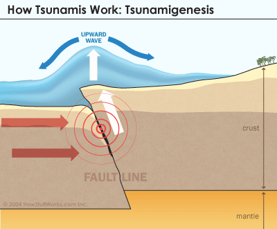 s this: where the earthquake was most violent, the sea receded and was then pushed back with even greater violence, thus bringing about a flood. Such a thing would not have happened without an earthquake” (Peloponnesian War, Book III.89)(b). However, there are also conditions that can produce tsunamis inland, such as occurred around 500 AD inundating Geneva in the Alps(k)(m).
The word ‘tsunami’ first appeared in an English language publication in the September 1896 edition of National Geographic Magazine in which the devastation caused by an earthquake wave in Japan was graphically described.
Recent studies(g) indicate that a similar tsunami saved the Greek town of Nea Poteidaia from a Persian attack in 479 BC. Herodotus in reporting the event attributed the Persian defeat to divine intervention by Poseidon, god of the sea.
A similar event on an even greater scale has been one of the suggestions as the possible cause of the flooding of Atlantis. A 2002 paper(a), by Louisiana State University geologist, Gary Byerly and his team, identified an ancient asteroid impact that generated a tsunami that “swept around the earth several times, inundating everything except the mountains”. The study of ancient tsunamis is at a very early stage of development.
A 2019 report was published online in 2022 in which it was revealed that the Yucatan asteroid impact credited with wiping out the dinosaurs 65 million years ago generated mile-high tsunamis that travelled halfway around the world. One wave was estimated to have been 1.8 miles high(ae).
Ivan T. Sanderson in one of his books, Investigating the Unexplained [768], recounts an 1863 report of a 200-foot high tsunami that sped up the Ganges and Houghli Rivers in India killing tens of thousands of people without ‘snapping-off’ trees. He contrasts this with the tree stumps covering acres around East Creek, New Jersey that have all been broken off at the same height and where he suggested that only a tsunami could have caused such widespread and uniform destruction. In view of the fact that some of these cedar trees had six-foot diameter trunks, he speculates on the possible size of a tsunami that could bring about such extreme damage.
Perhaps even more relevant to the study of Atlantis is the evidence gathered by Jürgen Spanuth in his chapter on the ‘Natural Catastrophes of the 13th Century’ including an interesting section on tsunamis [015.167].
Marc-André Gutscher of the University of Western Brittany in Plouzané, France, has discovered evidence of an ancient tsunami on Spartel Island, an Atlantis candidate, in the Gulf of Cadiz. Georgeos Diaz-Montexano has pointed out that Josephus, the 1st-century Jewish historian, seems to describe the devastation caused by its assault on the Atlantic coast of Spain and Portugal at the time of the Lusitanians and Cantabrians in the 1st millennium BC.
Some years ago, Richard Freund, a professor from the University of Hartford, expressed support for the Donana Marshes of Southern Spain as the location of Atlantis, he attributed the swamping of the locality and the submergence of Atlantis to the power of a tsunami(ah). In 2003, Werner Wickboldt claimed that following an examination of satellite photos of Doñana, he detected structures that very closely resemble those, which Plato described in Atlantis. Freund, claims to have led a team to study the area and has had work included in a March 2011 National Geographic documentary, Finding Atlantis. However, Spanish anthropologist Juan Villarias-Robles who has worked on the site for some years has declared that Freund did not lead the investigations on the site and in fact spent less than a week there. Wickboldt’s images turned out to be either smaller than expected or were from the Muslim period. Evidence for Atlantis (or Tartessos) has not been found there.
In the late 1970s, Booth & Fitch suggested in Earthshock[1295] that tsunamis may have been responsible for the devastation of Atlantis, an idea that has gained in popularity.
Sergio Frau has postulated that the Atlantean civilisation on Sardinia was destroyed by a tsunami.
Professor Stefano Tinti of Bologna University visited Sardinia and explained(r) “that until the 1980s no one was aware that tidal waves had occurred in the Mediterranean. But since 2004 scientists have identified 350 events of this type over a 2,500-year period,” and regarding the Sardinian tsunami “So what would have been required in our case?” he then asked. “We’re talking about a huge volume of water, some 500 metres high [the elevation up to which the nuraghi were affected]. Only a comet could do that if the impact occurred very close to the coast and in a very specific direction,” he asserted. An event of this sort may have occurred near Cagliari, with the resulting wave devastating the plain of Campidano.”
Tinti has also noted(w) that generally speaking, the majority of tsunamis are generated by seismic rather than volcanic activity. Globally, volcanic tsunamis account for only 2% of the total, however, the profusion of volcanoes in Southern Italy has considerably increased this percentage. Furthermore, according to a recent article on the BBC website “The scale of the tsunami hazard from volcanoes that collapse into the sea has been underestimated.”(x)
A 2022 report of a recent study(ac) revealed some new interesting information.
“Archaeologists have found evidence of the largest known earthquake in human history — a terrifying magnitude-9.5 megaquake that caused a 5,000-mile-long (8,000 kilometres) tsunami and prompted human populations to abandon nearby coastlines for 1,000 years.
The earthquake struck about 3,800 years ago in what is now northern Chile when a tectonic plate rupture lifted the region’s coastline. The subsequent tsunami was so powerful, it created waves as high as 66 feet (20 meters) and travelled all the way to New Zealand, where it hurled car-size boulders hundreds of miles inland, the researchers found.”
More recently, Dhani Irwanto has written about the probable effect of tsunamis on his Indonesian Atlantis(y). Studies of the sedimentary record in a sea cave in Sumatra have revealed the frequency and strength of tsunamis in the region over a five-thousand-year span from 5900 BC until 900 BC(u).
Tsunamis are also associated with the destruction on Crete following the eruption of Thera in the 2nd millennium BC. A TV documentary entitled Sinking Atlantis(i), provided graphic evidence of tsunami damage on Minoan Crete(h).
J.V.Luce cited[120.119] a number of local legends from around the Aegean that may have originated with the tsunami that followed the eruption on Thera.
However, the extent of this damage is strongly contested by W. Sheppard Baird(j) and he proposes instead that it was in fact more likely to have been a pyroclastic surge from the Theran eruption that caused the most damage.
A recent report(d) concludes that a large tsunami generated by the volcanic activity of Mt. Etna around 6000 BC produced waves up to 43 feet high that struck the coasts of Greece and Libya. This event would have caused devastation on nearby Malta, where evidence of past tsunamis was published in the journal Zeitschrift für Geomorphologie. The research was carried out over three years by scientists from the University of Portsmouth, led by Dr Malcolm Bray with assistance from colleagues at the Department of Geography at the University of Malta(n). A 1693 earthquake generated the earliest recorded tsunami on Malta and as recent as 1908 Malta was hit by a tsunami that resulted from a catastrophic earthquake in the vicinity of the Strait of Messina(p).
On the Atlantic west coast of Ireland, we have a 250 km2 region, in County Clare, known as the Burren, which consists of limestone denuded of soil cover. Recently, strong evidence was discovered suggesting a 4000 BC tsunami in the region(o). For me, the karst landscape of the Burren is reminiscent of parts of Malta.
Plato’s description does not support the idea of a tsunami as the primary cause of Atlantis’ inundation since tsunamis will eventually subside and return to the ocean, whereas Atlantis was still underwater centuries after the event, causing a permanent navigation hazard. John Michael Greer makes a similar point [345.126] in relation to the megatsunami which struck Madagascar in 2800 BC. Evidence of other ancient megatsunamis in Hawaii was presented at the 2012 meeting of the American Geophysical Union(l). The power of megatsunamis is highlighted in an article on the UK’s MailOnline website(t). Atlantisforschung also offers a lengthy article about megatsunamis(af).
Recent excavations at Olympia on the Peloponnese peninsula, the location of the original Olympic Games, have pointed to the site having been repeatedly hit by devastating tsunamis during the past 7,000 years(c).
The Bunurong tribe in Australia has a ‘myth’ that explains the creation of Melbourne’s Port Philip Bay. A recent article(e) has linked this to a tsunami that resulted from the impact of Comet Manhuika southwest of New Zealand in the 15th century. A more cautious view of this event is expressed elsewhere(f).
The excellent livescience.com website has an interesting list of ten history-making tsunamis(q), while Wikipedia offers an extensive list of European tsunamis from prehistoric times until the present(s).
A 100-metre-high tsunami, caused by a landslide, one of the highest ever recorded was experienced in a remote area of Greenland in June 2017. Four lives were lost and eleven houses were destroyed in the fishing village of Nuugaatsiaq, located on an island about 20 kilometres away(v).
The Greenland event would have been greatly overshadowed, literally, by the tsunami generated by the asteroid that struck Mexico’s Yucatán Peninsula around 66 million years ago that killed off the dinosaurs. According to a 2021 report(z) it has been estimated that the impact produced a tsunami nearly a mile high!
In 2020, David Keys, author of Catastrophe [1330] wrote an article for the UK’s Independent newspaper outlining the most recent research into the 6200 BC tsunami that destroyed Doggerland. “It is estimated that multiple giant waves inundated some 2,700 square miles of land – from Scotland in the north to Norfolk in the south. New underwater research carried out by the universities of Bradford, Warwick, St Andrews and Wales has for the first time discovered that the tsunami devastated parts of East Anglia and adjacent land which is now submerged beneath the southern part of the North Sea.” (ab)
However, 6200 BC would seem too early for the destruction of Plato’s Atlantis, apart from which the idea that at such an early date anyone living on Doggerland would have any knowledge of Athens or have the means or even a reason to invade a city 3,000km away (over 6,000km by sea). Even if they undertook such a venture, on arrival they would have to wait around for a couple of millennia before anything worth invading was developed there!
Stuart L. Harris published a paper in 2020 entitled 5760 BC: tsunami at Rhine Valley caused by Planet X(ad). This was based on a translation of a long inscription written on a cliff face in Germany. Harris explains that in 5760 BC “satellites from a mysterious Planet X struck the continental shelf of Texas “that pushed a piece of the shelf the size of Massachusets into the Gulf. Above the displaced shelf, the sea towered 1.9 km high. The resulting tsunami dispersed in all directions and obliterated coastal communities around the North Atlantic.
In Germany, it surged over the Ruur Mountains west of the Rhine Valley, flooded the middle Rhine between Mainz and Karlsruhe, and continued over the eastern escarpment toward Heilbronn. It left extensive ripple marks in the Rhine Valley and the eastern plateau.” Harris offers some interesting data to support this claim.”
On August 12, 2021, within minutes of each other, two earthquakes struck the South Sandwich Islands of the South Atlantic. National Geographic reported “These rumblings, which occurred on August 12, 2021, were not unusual on their own, since the islands sit atop a combative meeting of tectonic plates. The odd part is that they were followed by a tsunami powerful enough to show up on distant shores along the Atlantic, Pacific, and Indian Oceans. Although the swell wasn’t destructive, it was the first since the catastrophic tsunami of 2004 to be recorded in three different oceans(aa).“
The Live Science website reported(ag) “On Jan. 15, 2022, the Hunga Tonga-Hunga Ha’apai submarine volcano — a large, cone-shaped mountain located near the islands of the Kingdom of Tonga in the South Pacific — erupted with a violent explosion. The eruption generated the highest-ever recorded volcanic plume, which reached 35 miles (57 kilometers) tall. The outburst triggered tsunamis as far away as the Caribbean, as well as atmospheric waves that traveled around the globe several times.” and “The Tonga underwater volcanic eruption rivaled the strength of the largest U.S. nuclear bomb and produced a “mega-tsunami” nearly the height of a 30-story skyscraper.”
In May 2026, the sciencealert.com website published the following report;
“In 2025, the retreating South Sawyer Glacier in Alaska’s Tracy Arm, a fjord near Juneau, triggered a large landslide.
As debris from the landslide smashed into the water, it triggered a megatsunami that swept down the fjord into the ocean.
On its way down, it reached a maximum height of 481 m (1,578 ft) – the second-highest tsunami known to humans.
A team of scientists led by Dan Shugar, a geomorphologist at the University of Calgary in Canada, reconstructed the tsunami and published their results in Science(ai) .
‘The Tracy Arm landslide and tsunami wasn’t a disaster, but it was a near miss,’ lead author Shugar said in a video recapping the event.
‘If the landslide had occurred five or six hours later than it did, at least one ship would have been up close to the glacier, and the landslide would have had a very different outcome’.”
(a) http://web.archive.org/web/20191216194404/https://atlantipedia.ie/samples/archive-2931/
(c) Olympia hypothesis: Tsunamis buried the cult site on the Peloponnese (archive.org)
(d) https://www.livescience.com/1170-towering-ancient-tsunami-devastated-mediterranean.html
(e) https://www.thunderbolts.info/wp/2012/02/10/mega-tsunamis-chinese-junks-and-port-phillip-bay/
(g) https://www.livescience.com/19809-ancient-wave-real-tsunami.html
(h) Sinking Atlantis | Full Episode | Secrets of the Dead | PBS (archive.org)
(i) https://video.pbs.org/video/1204753806/ (link broken)
(j) The ‘Sinking Atlantis’ Tsunami Myth Debunked (archive.org)
(k) Tsunamis in the Alps? (archive.org)
(o) https://www.irishexaminer.com/ireland/6000-year-old-settlement-poses-tsunami-mystery-193230.html
(p) https://www.timesofmalta.com/articles/view/20050109/letters/tsunami-events-in-malta.102636 (link broken)
(q) https://www.livescience.com/28296-tsunamis-that-changed-history.html
(r) https://www.theguardian.com/science/2015/aug/15/bronze-age-sardinia-archaeology-atlantis
(s) https://en.wikipedia.org/wiki/List_of_tsunamis_in_Europe
(u) 5,000-Year-Long Tsunami Record Found in Guano-Encrusted Sumatran Cave – Seeker (archive.org)
(v) https://www.nature.com/news/huge-landslide-triggered-rare-greenland-mega-tsunami-1.22374
(w) https://www.springer.com/gp/book/9780792323167
(x) (BBC Sept. 3, 2019) https://www.bbc.com/news/science-environment-49568107
(y) https://atlantisjavasea.com/2015/08/31/earthquakes-and-tsunamis/
(z) Chicxulub Asteroid Impact Created a Giant Tsunami Nearly a Mile High | Mysterious Universe (archive.org)
(aa) Source of mysterious global tsunami found near Antarctica (nationalgeographic.com)
(ac) Scientists find evidence for biggest earthquake in human history | Live Science
(ad) https://www.migration-diffusion.info/article.php?id=771
(af) Mega-Tsunami – Atlantisforschung.de (atlantisforschung-de.translate.goog)
(ag) 1st mega-tsunami on record since antiquity was triggered by Tonga volcanic eruption | Live Science
(ah) Lost city of Atlantis, swamped by tsunami, may be found | Reuters
Shardana
The Shardana (or Sherden) is usually accepted as another name for one of the groups that comprised the maritime alliance of Sea Peoples. The earliest reference to the Shardana is in the Amarna Letters (1350 BC). However, they are also recorded as mercenaries in the Egyptian army. Since a number of writers have linked the Sea Peoples with the Atlanteans, the Shardana may be legitimately included in any comprehensive search for the truth of the Atlantis story.
The Shardana do appear to have a more complicated history than we are initially led to believe. They are first mentioned in the Amarna Letters (14th century BC.) where they are depicted as part of an Egyptian garrison, after that, some of them were part of the personal guard of Rameses II, later still they are listed as part of the Sea Peoples. A subsequent reference describes them occupying part of Phoenicia.
They are generally identified with the ancient Sardinians, who were the builders of the Nuraghi, although some have reservations. Leonardo Melis, a Sardinian, has written extensively[478] on the subject. Links have also been proposed between the Shardana and the lost tribe of Dan and even the Tuatha De Danaan who invaded Ireland.
Trude & Moshe Dothan in their People of the Sea[1524] identify the Shardana as part of the ‘Aegean Sea Peoples’, who settled on the coast of Caanan[p.214]. They also note that “There was as well linguistic and archaeological evidence connecting them with the island of Sardinia, where Mycenaean IIIC:1b pottery was found. Sardinia may have been either their original homeland or, more probably, one of their final points of settlement.”
D’Amato & Salimbeti concluded that ” on the basis of the combined evidence from Corsica and Sardinia, it is difficult to conclude with any confidence if the Sherden originated from or later moved to this part of the Mediterranean.” They find the second theory “more reasonable.”[1152.17]
David Rohl has suggested that the Shardana had originated in Sardis in Anatolia, but “ended up settling in the western Mediterranean, first on the Italian coastal plain west of the Apennines and then in Sardinia – which is, of course, named after them – and Corsica. Their name was clearly pronounced ‘Shardana.'” [229.410]
DNA testing has shown links between Sardinia and Anatolia in Turkey. The late Philip Coppens also noted that the Sardinians are genetically different to their neighbours on Corsica and the mainland of Europe and suggested an Eastern Mediterranean origin for them.(a)
Giovanni Ugas an archaeologist at the University of Cagliari has written extensively on the subject of the Shardana, who he claims were the builders of the nuraghi. Ugas has also touched on the subject of Atlantis, which he locates in northwest Africa(b), across Morocco, Algeria and Tunisia.
The Cogniarchae website(d) has proposed a number of possible locations as the original homeland of the Shardana, finishing with a look at Sarmatia (now Central Ukraine) – “Moreover, the term Shardan has clearly more roots in this part of the world than anywhere else. Namely, Sardanapalus was the name of the last Assyrian king, and many names are containing Shar and Shardan in ancient Persia and Assyria. In fact, the word “Shar” is closely related to the words “Shah” and “tzar” – all meaning “king, emperor”. Shar Kalli Shari was an Akkadian king from the 3rd millennium BC.”
Obviously further research is required to try to establish with greater certainty the exact origins of the Shardana and their links, if any, with Sardinia and/or Atlantis.
(a) http://web.archive.org/web/20191216195547/https://atlantipedia.ie/samples/archive-2131/
(b) L’Isola del continente: L’Atlantide tra fantasia e storia (1) [di Giovanni Ugas] | Sardegna Soprattutto (archive.org) (Italian)
(c) SP INTERVISTA>GIOVANNI UGAS: SHARDANA – Sardinia Point (archive.org)
(d) Origins of the “sea peoples” – The Sherden, the Shekelesh, the Peleset – COGNIARCHAE
Frau, Sergio
 Sergio Frau (1949-2025) was a journalist with Italy’s leading daily newspaper La Repubblica. He was also the author of a hefty 672-page volume, Le Collone d’Ercole: Un’inchiesta[302] that firmly places Atlantis in Sardinia and the Pillars of Hercules in the Strait of Sicily, between Tunisia and Sicily. He supported this contention with references to ancient writers such as Herodotus and Dicaearchus.
So far, Frau’s book is only available in Italian and from 2008 in German(c).
Professor Louis Godart offered wholehearted support for Frau’s location for the Pillars of Herakles in a short paper in Italian(o) and English (Archive 7096).
Frau contended that a catastrophic inundation of some sort destroyed the mysterious ancient civilisation on Sardinia, known as the Nuraghi, after whom the numerous ancient towers on the islands are named. A megatsunami around 1200 BC, is accepted to have struck from the south. A more specific date on offer is 1175 BC. However, Carthaginian and Roman remains have been found underneath the sediment deposited by this tsunami,conflicting with the date and greatly weakening the suggestion that Atlantis was destroyed by this event (i).
Frau believed that some of the survivors migrated to the Italian mainland and founded the Etruscan civilisation, while others formed part of the Sea Peoples who attacked Egypt.
His book sold over 30,000 copies in Italy, his theory received favourable attention from UNESCO and an exhibition based on his work has been shown in Paris and Rome. This is in sharp contrast to the 250 historians who reportedly denounced his theory. Then there are many others, such as Hannah Fielding, the novelist, who is very attracted to Frau’s ideas(b).
A collection of reviews of Frau’s book, in English, is available(k).
Frau has received support for his theory from the well-known geologist, Mario Tozzi. Another commentator, Silvio Diego Novo has also given his backing to the idea(b).
Robert Ishoy proposed a similar theory(a) on the Internet at least two years before Frau had his book published. However, the earliest claim that Atlantis had existed on Sardinia was made in 1982, by Paolo Valente Poddighe, who then accused Frau of plagiarism.
The Atlantisforschung.de website has also offered a review of Frau’s book on the tenth anniversary of its publication, including a number of criticisms and particularly its inability to generate any great support in either academic or Atlantis circles.(n)
Although the media have generally given a positive response to Frau’s book, Thorwald C. Franke has panned it, denouncing it as pseudo-science(d), but reluctantly conceded that Frau “could nevertheless be partially right! For the record, I agree with Franke’s limited support.
In addition, at the instigation of Alessandro Usai, 71 Sardinian archaeologists, geologists and historians have signed a 21-point refutation of Frau’s theory(e). Antonio Usai (relation?) has also endorsed the criticism in this document(j). An English/Italian version of the document is available as Archive 2704.
Nevertheless, the Atlantika has published over twenty short papers, generally supportive of Frau from what has been called a ‘Jury of Experts’(m). However, the general focus of that support was not related to Atlantis, but to endorse the credibility of Frau’s location of the Pillars of Herakles, before the term was applied to the Strait of Gibraltar. Frau maintained that it was used to describe a location at the Strait of Sicily. This brings us to another question, which Strait of Sicily? In ancient times, that term was also a reference to the Strait of Messina, which, for me, makes more sense as today’s Strait of Sicily does not conform to any definition of a ‘strait’, while the Strait of Messina is a perfect example.
In August 2016, Frau received another round of publicity following an interview with Sputnik news media(f). The interview added nothing of consequence, although the text was copied by other media outlets. Nevertheless, this did not hold back Jason Colavito from his standard atlantiphobic attack(g).
So far, Frau’s book is only available in Italian and German(c). In 2017, Frau published a sequel to his Le Collone d’Ercole, entitled Omphalos[1553] in which he expanded on aspects of his Sardinian location for Atlantis in a hefty 1154-page volume, which once again is currently only available in Italian. He highlighted the fact that lying on the 40th parallel, Sardinia is virtually halfway between the west coast of America ((11,359 km distant) and the Pacific coast of Japan (11,350) and so can be truly considered the navel (or omphalos) of the world! It should be obvious that Sardinia is also midway between any number of other paired locations, so what?
An extensive collection of snippets from Omphalos is also available(l).
2018 saw Frau win a defamation case against Fabrizio Frongia and damages of 22,500 Euro(h), as a result of comments in Frongia’s book Le torri di Atlantide[1609] (The Towers of Atlantis).
I regret having to report that Sergio Frau passed away in September 2025.
(a) https://web.archive.org/web/20230117181939/http://www.atlantisdiscovered.org/Home.htm
(b) Hannah Fielding: Home – Award-Winning Romantic Books (archive.org)
(c) https://www.atlantis-scout.de/index_engl.htm
(d) https://www.atlantis-scout.de/atlantis-sergio-frau-english.htm
(e) http://web.archive.org/web/20211127165840/https://atlantipedia.ie/samples/51915-2/
“La Sardegna (che non esiste) di Sergio Frau”, l’invito di Alessandro (…) – Atlantikà (archive.org) (Italian)
(h) https://www.omphalos-sardegna.it/crollano-le-torri-di-atlantide-giustizia-per-sergio-frau/
(i) https://scienze.fanpage.it/sardegna-atlantide-la-tesi-dello-tsunami-secondo-gli-specialisti/ (Italian)
(j) http://www.lavocedifiore.org/SPIP/article.php3?id_article=3095
(k) http://www.colonnedercole.info/pdf/txtenglish.pdf
(l) Omphalos the book – OMPHALOS (omphalos-sardegna.it)
(m) La Giuria degli Esperti – Atlantikà (archive.org)
(n) Sergio Frau – Atlantisforschung.de
(o) http://web.archive.org/web/20210512163051/http://www.colonnedercole.it/spip/spip.php?article15 (Italian)
Pantelleria
 Pantelleria was formed by ancient volcanic action, but even as recently as 1891, there was a submarine eruption off its NW coast(j). This ancient vulcanism created large deposits of highly-prized obsidian on the island. Because of its importance for tool making, it was traded extensively in the Central Mediterranean from the Neolithic period onwards(g).
The island, formerly known as Cossyra, is an Italian-controlled island between Sicily and Tunisia. One suggestion, from Andis Kaulins has been that it was the original Gaderia(a).
This conclusion is probably based on the existence of a location on the northeast coast of the island called Gadir. However, it must be kept in mind that Gadira or variants of it are frequently found in the Mediterranean region, usually at the site of former Phoenician settlements. However, north of Pantelleria is the Egadi Islands(c), another name evocative of Plato’s Gades.
Gades has been associated with Erytheia in the story of the Trials of Hercules, so if the Map Mistress website is correct in locating Erytheia(d) between Pantelleria and the Egadi Islands, it would confine all the ‘Trials’ in the Central and Eastern Mediterranean, consequently, locating the Pillars of Heracles somewhere in the latter region.
More recently, some authors have identified the Straits of Sicily as being the location of the Pillars of Heracles referred to by Plato in his tale of Atlantis. A land bridge between Sicily and Tunisia, including Pantelleria, has also been suggested, but this is considered unlikely according to bathymetric data.
Novelist Samuel Butler (1835-1902) identified Pantelleria as Calypso’s Island, but the idea received little support(i).
A fortified Neolithic village has been unearthed on its west coast and ancient structures, known as ‘sesi’, similar to the nuraghi of Sardinia, are to be seen in the southeast. One in particular, known as the Grande Sese, is a 5,000-year-old six-metre high mausoleum, containing twelve ‘cells’. “The civilization who built this and another sese nearby are believed to have settled on the island after arriving from Northern Africa.”(h)
In 2005, jewellery in the style of the Egyptian Second Intermediate Period (1700-1550 BC) was discovered on the island. This would add to the opinion that Pantelleria was a major trading and cultural crossroads in ancient times.
Massimo Rapisarda has commented that “a good candidate to host a primordial civilization might have been the archipelago then existing in the Strait of Sicily, a natural maritime link between Tunisia and Italy, prized by the presence of an obsidian source at Pantelleria.”(f)
In August 2015, it was claimed(b) that a manufactured stone column was found on the Pantelleria Vecchia Bank, just north of the island of Pantelleria, in 40 metres of water. It is claimed that the area was formerly the site of an archipelago, if not actually connected to Sicily, before the last Ice Age ended around 7350 BC. The monolith was dated using shells extracted from it. It took no time before the discovery was linked by a number of sites with Plato’s Atlantis. While I believe that the area was part of the Atlantean domain, I am more inclined to date its expansionist intentions to a much later period, such as the 2nd millennium BC.
(a) https://web.archive.org/web/20200130221548/http://www.lexiline.com/lexiline/lexi60.htm
(c) https://web.archive.org/web/20180627052748/http://www.mapmistress.com/egadi-islands-marettimo-levanzo-favignana.html (text only)
(d) https://web.archive.org/web/20180831115550/http://www.mapmistress.com/pantelleria-erytheia-sicily-tunisia.html (text only)
(e) Stone Pages Archaeo News: Ancient Egypt gems on Italian isle (archive.org)
(g) https://www.academia.edu/33910010/Characterization_of_obsidian_sources_in_Pantelleria_Italy
Gibraltar Landbridge or Dam
A Gibraltar Landbridge or Dam is generally accepted to have existed on several occasions during the earth’s history. There is a broad consensus among geologists that the last time an enclosed and desiccated Mediterranean had its barrier to the Atlantic breached, was around 5.3 million years ago. A paper by Daniel García-Castellanos on the refilling of the Mediterranean deserves a read(u).
Today, we generally think of the Strait of Gibraltar as the only gateway between the Atlantic and the  Mediterranean, while in fact there is evidence that millions of years ago the Strait was closed but there were earlier access routes between the two bodies of water(n). The Betic Corridor in the north, which later became part of the Spanish Guadalquivir Basin and the Rifian Corridor in the south, in what is now Morocco(t).
However, a number of experts in different fields (noted by Van Sertima) have opted to suggest a more recent landbridge, perhaps 120,000 years ago, in order to explain some of the faunal migrations from Africa to the Iberian Peninsula[322].
When the last opening of the Mediterranean was demonstrated by Kenneth Hsu to have taken place 5.5 million years ago, the idea of a landbridge at Gibraltar being destroyed within the memory of man seemed rather unlikely. However, when I saw the 2012 bathymetric maps of the Mediterranean produced by Brosolo, Mascle & Loubrie(v) relating to the Younger Dryas Period, it raised new questions for me.
However, Hsu’s date for the last flooding of the Mediterranean has, understandably, found little support from young-Earth creationists, such as Lambert Dolphin(o). and Barry Setterfield, who have striven to reconcile the irreconcilable with obscure ideas, such as changes in the speed of light!
The 18th-century writer Georges-Louis Buffon speculated as early as 1749, on the existence of a Gibraltar Dam. Alexander Braghine refers [156.21] to Bishop Tollerat, a contemporary of Bory de Saint Vincent, claiming that a Gibraltar landbridge was breached by an earthquake and led to the submergence of Atlantis. Unfortunately, I have been unable to track down Tollerat.
Even popular fiction featured the idea of a Gibraltar landbridge. In 1869, Mark Twain, in chapter 7 of Innocents Abroad [1123] wrote of a then-current theory that there had been dry land between Gibraltar and North Africa, allowing the passage northward of the so-called ‘Barbary apes’ that live on the ‘Rock’ today.
In 1921, H.G.Wells, in The Outline of History, offered a graphic, although speculative, description of the breaching of the Gibraltar Dam(g). He wrote that “This refilling of the Mediterranean, which by the rough chronology we are employing in this book may have happened somewhen between 30,000 and 10,000 B.C., must have been one of the greatest single events in the pre-history of our race.”
Manuel Sánchez de Ocaña was the Spanish Lieutenant General during the 1909 war in Africa. In a rare 1935 book, Accion de España en Africa(a) (Spanish Action in Africa) he refers to the ancient isthmus that linked Spain and North Africa, ,as well as landbridges linking Europe and America, on which he believed Atlantis had been situated.
François de Sarre (1947- ) was a noted French evolutionary zoologist who proposed that a landbridge had existed at Gibraltar, which was only destroyed in relatively recent times, possibly in the second millennium BC. In support of his view, he quotes Pomponius Mela, Diodorus Siculus and Pliny. He has also published a paper, in English, supporting his opinion with a spectrum of faunal evidence(k).
Others have ventured further and proposed that a dam existed within the experience of man and that its last destruction led to the sinking of Atlantis, which many claim was located in the Mediterranean. H. S. Bellamy refers to Strato quoted by Strabo, declaring that originally the strait did not exist but that the barrier was broken through in a cataclysm. Bellamy also quotes Seneca describing how Spain was separated from Africa by earthquakes. Neither of these references could have originated without human witnesses.
Alexander Braghine also added to the idea of a relatively recent landbridge when he wrote[156.139] “We possess a whole series of records of the width of these Straits, left by ancient and medieval writers of various centuries. At the beginning of the fifth century B.C. the width was only half a mile, but the writer Euton in 400 B.C., estimated it at 4 miles; Turiano Greslio, in 300 B.C., at 5 miles; and Titus Livius, at the beginning of the Christian Era, at 7 miles. Victor Vitensa, in A.D. 400, gives the width of the Straits as equal to 12 miles, and at present it is 15 miles wide.” John Jensen offers the same information as a graphic(q).
C. C. M. Hardy subscribed to the view there had been a dam at Gibraltar that was breached around 4500 BC, with such a force, that it also led to the destruction of a landbridge between Tunisia and Italy. He believed that remnants of Atlantis will be found in the seas around Greece.
C. S. Rafinesque, the famous naturalist, claimed that there was a Gibraltar landbridge that was destroyed 654 years after Noah’s Flood. These claims are to be found in chapter 14 of Vol II of The American Nations, published in 1836. This volume can now be downloaded for free(e). A creationist website(i) links the breaching of the landbridge with Noah’s Deluge, which the author claims not only flooded the Mediterranean, but also spilled into the Black Sea, the Red Sea and also the Persian Gulf. (see below)
 The standard argument against the landbridge theory is that although the Atlantic was dramatically lower during the last Ice Age it was not sufficient to expose a dry route between Spain and Africa at Gibraltar. However, it should be noted that the underwater sill between the Atlantic and the Mediterranean would have been much higher than now. When we consider that the breaching of a landbridge at Gibraltar would have caused an incredible flow of water through the breach (hundreds of times the flow of Niagara Falls), scouring its bottom, so that by the time the levels in the Atlantic and the Mediterranean had equalised, the erosion of the sill between them would have been considerable and when viewed today, would misleadingly suggest that the Mediterranean had not have been completely cut off from the Atlantic during the last Ice Age. In the future, the consequence of this is that when (not if) the next Ice Age begins, the ocean levels will have to drop even lower if the Mediterranean is to be isolated from the Atlantic once again. An example of what a sudden release of large bodies of water can do is visible in the scablands of North America, created by the breaching of the glacial dam retaining Lake Missoula.
The Spanish researcher, Paulino Zamarro, contends, in his 2000 book, Del Estrecho de Gibraltar a la Atlantida that a Gibraltar dam was created by silting when the Atlantic was very much lower during the last Ice Age and that it lasted until 7,500 years ago, when it was breached and destroyed Atlantis, which he locates in the Cyclades, with the island of Melos containing its capital city. Details of his theory can be found on the Internet(d). A larger version of Zamarro’s map is shown on the right.
Other researchers such as, Constantin Benetatos, maintain that this idea is supported by comments of ancient writers, who suggest that at one time, the Mediterranean had no existence. The philosopher, Strato, supported by Seneca refers to the sundering of such a dam linking Europe and Africa. The same idea was expressed by Diodorus Siculus, who said that Africa and Europe were joined and separated by Heracles. Such ideas could only have arisen if there had been a Gibraltar Dam far more recently than the conventionally accepted 5.3 million years ago. The lowering of the ocean levels at the beginning of the last Ice Age and the exposure of a landbridge or dam between Spain and Morocco would have had the effect of drying out the Mediterranean, since the loss of water through evaporation in the region is greater than the amount of water from rivers that feed into it.
It is worth considering that, although the catastrophic breaching of the Bosporus and consequent expansion of the Black Sea is generally accepted as fact, there are no specific legends to support it apart from a reappraisal of the Flood of Noah. Therefore, it is not unreasonable to point out that there is little by way of local myth or legend relating to the breaching of a Gibraltar Dam, which is not proof that such an event did not occur. Although, as you will see below, a number of highly regarded Arabic scholars have endorsed the idea of a breached dam at Gibraltar.Furthermore, the area around the mouth of the Mediterranean is geologically unstable and could have been subjected to seismic activity that could have breached or even blocked the strait.
Alberto Arecchi agrees(a) with the concept of a historical land bridge at Gibraltar, but places its breach to around 2300 BC. John Jensen puts it about a millennium later and suggested that the sundering of the Gibraltar Dam was probably outward from the Mediterranean into the Atlantic(q) rather than the more generally accepted other direction. As already intimated, Constantin Benetatos also supported(b) the existence of the Gibraltar Dam.
Joseph S. Ellul, the Maltese writer was probably the first modern author to link the breaching of a Gibraltar landbridge with the destruction of Atlantis, which he claims to have been located adjacent to Malta. He identifies this submergence of Atlantis by the waters of the Atlantic with Noah’s Flood. Ellul interprets Genesis 7:11, 8:2, which refers to the “fountains of the great deep” bursting forth, as a reference to the collapse of the Gibraltar Dam. I think this is unlikely. However, I include links to two papers offering different interpretations of this expressio(r)(s)
David Hatcher Childress also supports the idea of such a landbridge and has ventured a date of around 9000 BC, for its collapse[620.261] and the consequent flooding of a desiccated Mediterranean.
Georgeos Diaz-Montexano, who has been searching for Atlantis off the coast of Spain and Gibraltar, has favourably referred to Zamarro’s silting theory and included the illustration shown above, from Zamarro’s book on his websites. A further reference to silting can be read on another website(f).
When the Mediterranean eventually filled up, it is highly probable that it was then that the pressure of its waters led to the flooding of the Black Sea. It is reported that there are scouring marks at the entrance to the Black Sea, similar to those at Gibraltar. The date of the putative collapse of the Gibraltar Dam would therefore be marginally earlier, while the Mediterranean basins filled, than the accepted date for the breaching of the Bosporus, currently calculated to have been around 5600 BC.
Robert Sarmast’s apparently dormant theory of Atlantis submerged off the coast of Cyprus, under what is now a mile of water, is totally dependent on the existence of a Gibraltar Dam during the last Ice Age and being subsequently breached when the level of the Atlantic rose, or the even more improbable lowering of the seafloor by a mile, as a consequence of seismic/tectonic activity in the region.
On the basis of evidence(c) offered by the quoted classical writers, the fact that sea levels rose hundreds of feet after the last Ice Age and examples of water damage to temples on elevated ground in Malta and nuraghi, in Sardinia, it is not unreasonable to conclude that a rupturing of a landbridge at Gibraltar within the last ten thousand years was possible, if not probable.
The most dramatic suggestion regarding the creation of the Strait of Gibraltar has been offered by Terry Westerman(h), who proposed that the rupturing of the landbridge was caused by two meteor impacts.
Finally, it is worth considering the comments of a number of respected Arabic scholars such as, Al-Biruni, and Al-Mas’udi who lent support to the idea of a Gibraltar landbridge. Additionally, Al-Idrisi recounts how the Gibraltar landbridge was breached by Alexander the Great. While the introduction of Alexander, who was very highly regarded by the Arabs, is obviously a folkloric embellishment, it demonstrates an underlying belief in the existence of such an isthmus in the distant past. Adding strength to this idea is that al-Idrisi was born in Ceuta, on the African side of the Strait of Gibraltar and consequently, would undoubtedly have been fully aware of local traditions regarding a landbridge there in ancient times.
However, all that must be reconciled with the scientific findings of Kenneth Hsu, who dated the last opening of the Gibraltar Strait to 5.5 million years ago(m). This date has been unchallenged as far as I’m aware.
A paper published online in May 2022, would appear to contradict the idea that a landbridge blocking the  Gibraltar Strait had collapsed, flooding the Mediterranean and contributing to the destruction of Atlantis.
This paper(a) includes a map showing the gradual encroachment inland by the Mediterranean at Spain’s Pego-Olvia (opposite Ibiza), between 9000 BC and 8100 BC. This was the result of post-glacial melting of the glaciers gradually raised sea levels, allowing water to slowly move inland over the flat coastal plain, at a rate of about a kilometre every century. Little has changed since then, indicating that any suggested landbridge could not have been breached after 8100 BC, without a more significant expansion inland by the Mediterranean. It also suggests that in a scenario where a Mediterranean Atlantis was flooded during that period and particularly during the second millennium BC, it should still be in relatively shallow waters!
(a) https://www.liutprand.it/articoliMondo.asp?id=111
(b) http://web.archive.org/web/20191028003627/https://atlantipedia.ie/samples/archive-2365/
(c) https://www.freerepublic.com/focus/news/601935/posts
(d) See: https://web.archive.org/web/20180820052424/https://www.atlantidaegeo.com/autor.html
(f) https://wiki.answers.com/Q/What_was_the_depth_of_the_Mediterranean_Sea_during_the_last_Ice_Age
(g) https://archive.org/details/OutlineOfHistory
(h) The Formation of the Strait of Gibraltar (archive.org)
(i) https://www.makesyouthinkblog.com/?m=201204 (link broken) See http://web.archive.org/web/20220811211329/https://atlantipedia.ie/samples/archive-2536/
(k) https://www.migra(o)tion-diffusion.info/article.php?year=2015&id=477
(m) https://en.wikipedia.org/wiki/Messinian_salinity_crisis
(n) https://onlinelibrary.wiley.com/doi/10.1002/2014PA002719/full
(o) http://www.ldolphin.org/meddead.html
(q) https://www.migration-diffusion.info/article.php?id=514
(r) Wayback Machine (archive.org)
(s) https://www.grisda.org/origins-01067
(t) https://agupubs.onlinelibrary.wiley.com/doi/full/10.1002/2014PA002719
(u) https://mappingignorance.org/2014/02/07/how-the-mediterranean-was-refilled/
(v) Morpho-Bathymetric Map of the Mediterranean – CCMG (archive.org)
Sardinia
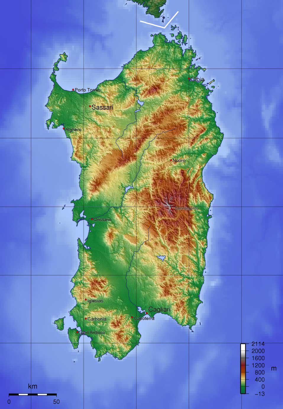
Sardinia is an autonomous region of Italy and after Sicily is the second largest island in the Mediterranean. Before the end of the last Ice Age, Sardinia had been joined to the European mainland because of the lower sea levels, which provided an easy access route for early settlers. Recent genetic studies revealed that “an exceptionally high proportion of the population is seemingly descended from people who have occupied it since the Neolithic and Bronze Age, between 8,000 and 2,000 years ago.”(al) Known to the Greeks as ‘Hyknusa’, during its long history, Phoenicians, Etruscans, Greeks and Romans have all left their mark on Sardinia. Before that, the megalith builders(j) were active in Sardinia and Corsica. A comprehensive history of Sardinia from the time of Atlantis is available online, in Italian and English(m). There is a tradition that Sardinia got its name from Sardus, son of Hercules(aa).
Sardinia’s important position in the ancient world was suggested by Mark McMenamin, a geologist at Mount Holyoke College in Massachusetts, who announced in Numismatist Magazine in November 1996(ar), that he believed that the Carthaginians produced gold coins, between 350 and 320 BC, depicting small maps of the Mediterranean world with India to the east and America to the west(e). When computer enhancement was applied to the images on some of those coins, he was amazed to note how the strange markings on them resembled maps made by Ptolemy, the Greek astronomer and geographer, who lived around 500 years later. The maps show what appears to emphasise the Mediterranean region, with Sardinia as a dot in the centre. The north coast of Africa appears at the bottom with Europe at the top, above the Phoenician homeland and India. The Strait of Gibraltar lies to the west; after that is the landmass of America. Some sceptics have been convinced of the correctness of McMenamin’s interpretation after seeing the enlarged images.
However, in 2000, McMenamin was obliged to confirm that the coins in question were fakes(as) as revealed in his book, Phoenicians, Fakes and Barry Fell [1738].
It has been suggested(p) that the ancient city (2000-1400 BC) of Nora, just south of today’s Pula, was thriving long before the arrival of the Phoenicians in the 8th cent. BC. It appears that contact between Sardinia and its trading partners suddenly ceased around 1400 BC, until the arrival of the Phoenicians. Phoenician inscriptions, one dated to the 11th century BC, were been found at Nora(q) in 1773. These inscriptions refer to Pygmalian, King of Tyre and to a battle between Sardinians and Phoenicians at Tarshish!
It has been postulated that the Shardana, one of the Sea Peoples of the 2nd millennium BC, gave their name to Sardinia and were probably the builders of the hundreds of Nuraghi there. Leonardo Melis, a native Sardinian, has studied and written at length on the subject. David Rohl, the archaeologist and advocate of revising generally accepted ancient chronologies, has argued[0232] that the Shardana were in fact originally from Sardis in ancient Anatolia and that they migrated westward to Sardinia following the collapse of the Hittite Empire.
Angelo Paratico also proposed a connection between the Lydian capital Sardis and Sardinia in a lecture delivered in Hong Kong in 2004(an). Wikipedia includes the following information “According to Timaeus, one of Plato’s dialogues, Sardinia and its people as well, the “Sardonioi” or “Sardianoi”, might have been named after “Sardò”, a legendary woman from Sardis, capital of the ancient Kingdom of Lydia in Anatolia.”(ao)
Apart from the enigmatic remains of the Nuraghic period, Sardinia has presented archaeologists with a greater mystery in the form of a structure at Monte d’Accoddi that closely resembles a Mesopotamian ziggurat. The earliest parts of the monument have been dated to circa 3000 BC – the same period during which comparable step pyramids were being built in Mesopotamia. Leonardo Melis has speculated that the name of the site, Accoddi, may be connected to the Akkadian civilisation. Step pyramids are also found in Sicily(c) and additionally the Le Barnenez cairn(ad) (4500-4700 BC), in Brittany, has a superficial resemblance to some of the Western Mediterranean ‘pyramids’.
Philip Coppens, author of The New Pyramid Age [759] has also written a paper(az) on Sardinia’s only known pyramid Monte d’Accoddi concluded that “despite almost forty years of excavation on the site, we know little as to what Monte d’Accoddi was, beyond the “visually obvious”. We do not know its use, nor why it was built, or why it was unique. However, the fact that there are so many questions, illustrates how little we truly know about “the pyramid movement” and how it inspired people all over the world, whether in Egypt, Peru, Mesopotamia or here in Sardinia, to begin the construction of pyramids. Currently, the oldest pyramids have been found in Peru. And though in the “Old World” we link pyramids specifically with Egypt, one group of people in north-western Sardinia had built one long before the Egyptian Pyramid Age ever began. That’s all we know, and that’s not much, is it?”
 Recent discoveries of statue menhirs on Sardinia have suggested that in the 4th millennium BC the island was part of a culture which spread from the Black Sea to the Atlantic(f).
The ancient-wisdom.com website, in a well-illustrated article, has drawn attention to the fact that the nuraghi, while very numerous, are not the only distinct form of megalithic monuments on the island, but there are two others known as ‘Tombes Gigantes’ (Giants Tombs) and ‘Domus de Janas’ (Spirit Homes).(ap)
Statue menhirs are also found on adjacent Corsica.
Apart from the Monte d’Accoddi feature, the statue menhirs and the thousands of nuraghi, Sardinia has another mystery to offer, in the form of cart ruts comparable with the better-known ruts on Malta. Dr Dominique Görlitz has also studied the cartruts found in Sardinia(ax). Images of these ruts can also be seen in a YouTube video(ay).
The end of the 18th and the beginning of the 19th centuries saw Antoine Court de Géblin and Delisle de Sales suggesting Sardinia as a remnant of Atlantis. However, the first person in more recent times to promote a Sardinian Atlantis was Paolo Valente Poddighe, who did so in 1982, but it was 2006 before he published a book[711] supporting this claim.
It was nearly another twenty years before Robert Paul Ishoy was the first to have a website(a) that promoted Sardinia as the site of Atlantis. His contention is that Atlantis was a powerful state based in Sardinia which controlled most of the western Mediterranean and was at its peak between 2000 BC and 1400 BC. Ishoy further contends that the Keftiu, Atlantean and Nuraghi cultures were all one. He contends that they made attempts to conquer the principal civilisations of the eastern Mediterranean, including the Minoans, Athenians and Egyptians. During one of these attacks, the Athenians, with the unexpected support of floods and earthquakes, defeated the Atlanteans. Ishoy has been planning an expedition to Sardinia to seek further evidence in support of his thesis.
In 2002, the Italian journalist, Sergio Frau, published a book[302], in Italian, which firmly located Atlantis just south of Sardinia, where it is now covered by water(ah). He argued that the Pillars of Heracles were at one time located as a boundary marker at the Strait of Sicily and later moved to Gibraltar as the Greek awareness of the western Mediterranean developed through expanded trade. Frau attributes this change of location to the geographer Eratosthenes, who flourished more than a century after Plato. Understandably, his theory has been greeted with the usual hail of criticism, but was given support by UNESCO when it organised a symposium on the theory in Paris in 2005, followed by an exhibition in Rome the following year.
In the interest of balance, Thorwald C. Franke’s critique(n) of Frau’s work is required reading, as well as a 21-point refutation of Frau’s book signed by 71 Sardinian historians, geologists and archaeologists(w). However, others such as Silvio Diego Novo have followed Frau’s lead(aq), while Aldo Bonincontro has also nominated Sardinia as Atlantis, which he did in a 2007 article, but without any reference to Frau!
It is obvious that there is considerable local support for the idea of a Sardinian Atlantis, but for some, this seems to be often linked with the independence movement on the island.
In June 2015 Frau, together with a number of Italian scientists, joined him when he visited Sardinia(x). They included historian Mario Lombardo; archaeologist Maria Teresa Giannotta; Claudio Giardino, a specialist in ancient metallurgy; cartographer Andrea Cantile; archivist Massimo Faraglia; and Stefano Tinti, a geophysicist and expert on tidal waves. Their objective was to study the evidence of a huge tsunami inundating the southern part of the island in ancient times.
A report in The Guardian (15/8/15) noted(y) that “Professor Tinti explained that until the 1980s no one was aware that tidal waves had occurred in the Mediterranean. But since 2004, scientists have identified 350 events of this type over a 2,500-year period,” and regarding the Sardinian tsunami, “So what would have been required in our case?” he then asked. “We’re talking about a huge volume of water, some 500 metres high [the elevation up to which the nuraghi were affected]. Only a comet could do that if the impact occurred very close to the coast and in a very specific direction,” he asserted. An event of this sort may have occurred near Cagliari, with the resulting wave devastating the plain of Campidano.”
Afterwards, Frau’s claim was given further attention(u) when an exhibition in the museum in Sardara, focused on that catastrophe and hit the island around 1175 BC. This cataclysm mainly affected the southern portion of Sardinia, covering it with a layer of mud. A geophysicist, Stefano Tinti, claims that the most likely cause of such an incursion would be an enormous tidal wave resulting from the impact of a comet in the Mediterranean. It was not surprising that Jason Colavito debunked(v) any linkage of Sardinia with Atlantis as well as the claim of a cometary impact, but avoided offering any explanation for the layer of mud.
A French website offers an interesting titbit regarding the extent of the mud, noting that “A nuraghe was discovered not far from the Sardinian town of Barumini.Les archéologues ont mis 14 ans pour ôter les 12 mètres de boue qui recouvraient ce monument. The archaeologists took 14 years to remove the 12 meters of mud that covered this monument”.
An alternative view of Sardinia and its nuraghi was offered(z) by Brian Cairns on the Thunderbolts website, where he claimed that the nuraghi were constructed to offer protection from cosmic electrical strikes. In his conclusion, he states that “while the evidence above is circumstantial, it seems that Sardinia had a very active electric environment.”
The late Vittorio Castellani, who had advocated locating Atlantis in the British Isles, was so impressed by Frau’s book that he changed his mind and supported the idea of a Sardinian Atlantis. Another keen supporter of Frau is Mario Tozzi, who has also suggested that if Sardinia was Atlantis, the mysterious Etruscans may have been Sardinians(r)(s). Further support has come from Mario Cabriolu and architect Paolo Macoratti, who identifies the Plain of Campidano with the Plain of Atlantis and locates the Atlantean capital further south in the Gulf of Cagliari, illustrated on a map on the sardolog.com site(t).
As Sardinia is still very much above water, it might seem an unlikely choice as the location of Atlantis. However, if it is accepted that the Pillars of Heracles were in fact situated in the Strait of Sicily, there are a number of features on Sardinia that would support the theories of Ishoy and Frau. There is evidence that the large plain of Campidano was inundated, from the south, by a tsunami, following an earthquake, in the Central Mediterranean in the 2ndmillennium BC. Professor Mauro Perra has argued against this(o) using extensive stratigraphic evidence. However, this tsunami also covered Punic and Roman remains indicating a much later date.
Furthermore, there are mountains protecting the plain from cold northern winds and rich mineral deposits are also found in the locality. Sardinia was well-known in ancient times as a source of silver as well as copper, iron and lead(af). There is also some evidence that a small but important quantity of tin was available on the island according to Stephen L. Dyson and Robert J. Rowland Jnr., in their recent history of Sardinia[1530]. The excellent phoenicia.org website comments that Sardinia can scarcely have been occupied by the Phoenicians for anything but its metals. The southern and south-western parts of the island, where they made their settlements, were rich in copper and lead; and the position of the cities seems to indicate the intention to appropriate these metals.
In 2010, Giuseppe Mura published a book of nearly 600 pages, in which he identifies the Gulf of Cagliari as the location of the Pillars of Heracles that previously led to a channel which gave access to the Plain of Campidano, which he claims(g)(h) was the Plain of Atlantis described by Plato.
 Furthermore, another young Sardinian has recently pointed out that colours associated by Plato with Atlantis, namely red, white and black, are found naturally on the island as well as excavated buildings of the Nuraghic period being painted in red and black stripes. The Sardinian regional flag also uses these colours.
We can expect that the future will see further development of the Sardinian Theory, which shows more promise than many of the other suggested locations.
For those interested in reading more about the history of Sardinia from its prehistory until the present should visit Claudio de Tisi’s website(i) (In Italian and English). It includes a review of Sergio Frau’s book on Atlantis. In 2011, travel writer Angela Corrias wrote a two-part article)(ab)(ac), which also includes a review of Frau’s theory.
There would appear to be growing support from local researchers on the island for a Sardinian Atlantis. One of the more recent is Giorgio Valdés, who equates Sardinia with Tartessos and Atlantis. This idea of Sardinia and Tartessos being identical goes back to the middle of the 20th century, when Wikipedia(k) tells us “that W.F. Albright (1941) and F.M. Cross (1972) suggested Tarshish was Sardinia because of the discovery of the ‘Nora Stone’ or ‘Nora Fragment’.” An extensive article(l) on the Nora Stele, in Italian, was written in January 2014, based on a translation by Jose Stromboni.
In 2013, Marin, Minella & Schievenin stated [972.43] that Sardinia was called Tartessos in ancient times, unfortunately, without providing any references.
In August 2016, Frau’s theory received a further spurt of publicity with an interview in Sputnik News, which was followed a few days later by the announcement that National Geographic was planning a documentary, co-produced by James Cameron and Simcha Jacobovici, based on Robert Ishoy’s Atlantis in Sardinia theory(ae).
However, Diaz-Montexano is also certain that the documentary will focus on his theory(ai). In the end, both theories were featured in what turned out to be a disappointing documentary.
In late 2016, Nicola Betti, Luciano Melis & Alessandro Mugria published Il mare addosso. L’isola che fu Atlantide e poi divenne Sardegna [1571] in which they add their support to the idea of Atlantis in Sardinia. They believe “with reasonable certainty that a large area of south-west Sardinia was hit by a swarm of iron meteorites in a period between 11,000 and 9000 BC,” which would have caused a catastrophic mega-tsunami(am).
Pier Paolo Saba, another Sardinian, suggests in his book Atlantide [739], that following a catastrophe around 10,000 BC, Atlantis was destroyed and survivors were dispersed to the Americas, Northern Europe and the Mediterranean. One group settled in Saba’s native Sardinia, where they became the Shardana and were responsible for the building of the thousands of nuraghi found throughout the island and were part of the Sea Peoples who attacked Egypt(au)(av).
In 2020, Marc Deneux published an ebook, Voyage en Atlantide (Voyage to Atlantis) in which he offers a ‘new hypothesis’ that places Atlantis off the coast of Sardinia. As you can see from the data above, the idea is far from new, as it can be traced back to the 18th century!
Luigi Usai is now promoting [1814] the idea that a conjoined Sardinia and Corsica had constituted the island of Atlantis and its capital was located at Sulcis at the southern end of Sardinia!(at) In 2024, Usai published a revised version of his thesis(ba). An important Phoenician city called Sulci was situated on the island of Sant’antioco, while the smaller island of San Pietro, just a short distance to the north, has two seastacks of the town of Carloforte, identified as the Pillars of Heracles by Professor Giorgio Saba. Usai has endorsed this identification.
In July 2021, I was sent a number of images that purported to show anomalous underwater images in the Central Mediterranean northeast of Malta. At first sight, they appeared to show extensive manmade features. However, further investigation by the person who sent them to me eventually discovered that the images were the consequence of the flawed computer interpretation of sonar data. In December 2021 Luigi Usai produced the same flawed imagery as evidence that he had discovered a lost submerged civilisation!
So that there is no misunderstanding, let me state that I have advocated a Central Mediterranean location for Atlantis for some years. If Sardinia holds that location, I am more than happy to congratulate Usai and Frau. But, I am not convinced by satellite imagery that has so often proven to be flawed.
I must include here a mention of the website of Pierluigi Montalbano, where he and various guest authors have written many interesting articles about Sardinia and its Nuraghic past, as well as Atlantis. The site is well worth a browse and as it has Google Translate built-in, making it easily accessible to all(aw).
(b) http://web.archive.org/web/20200215021700/https://atlantipedia.ie/samples/archive-2139/
(c) http://web.archive.org/web/20200215021735/https://atlantipedia.ie/samples/archive-2650/
(e) https://www.migration-diffusion.info/article.php?authorid=22
(f) Stone Pages Archaeo News: Huge number of statue menhirs found on a Sardinian wall (archive.org)
(g) https://gianfrancopintore.blogspot.com/2011/03/atlantide-in-sardegna-e-cagliari-i.html
(h) https://gianfrancopintore.blogspot.com/2011/03/atlantide-in-sardegna-e-cagliari-ii.html
(i) See: https://web.archive.org/web/20180204153209/https://www.lamiasardegna.it/files/storia-index.htm
(j) http://www.museodeidolmen.it/englishdefault.html
(k) https://en.wikipedia.org/wiki/Tarshish
(m) See: https://web.archive.org/web/20180204153209/https://www.lamiasardegna.it/files/storia-index.htm
(n) https://www.atlantis-scout.de/atlantis-sergio-frau-english.htm
(o) https://pierluigimontalbano.blogspot.ie/2014/04/uno-tsunami-cancello-la-civilta-nuragica.html (Italian)
(p) In Search Of Atlantis: Clues In Cagliari, Sardinia (archive.org)
(q) https://en.wikipedia.org/wiki/Nora_Stone
(r) Atlantide, Sardegna? » TOZZI DI SCIENZA – Blog – NATIONAL GEOGRAPHIC ITALIA (archive.org) (Italian)
(t) SardoLog – Sardegna è Atlantide? (archive.org)
(u) https://www.theguardian.com/science/2015/aug/15/bronze-age-sardinia-archaeology-atlantis
(v) https://www.jasoncolavito.com/blog/did-a-comet-destroy-atlantis-in-bronze-age-Sardinia
(w) “La Sardegna (che non esiste) di Sergio Frau”, l’invito di Alessandro (…) – Atlantikà (archive.org) (Italian)
(x) https://anthropologistintheattic.blogspot.ie/2015/11/was-sardinia-home-to-mythical.html
(y) https://www.theguardian.com/science/2015/aug/15/bronze-age-sardinia-archaeology-atlantis
(z) https://www.thunderbolts.info/wp/2015/11/20/neolithic-man-and-the-electric-universe/
(aa) https://en.wikipedia.org/wiki/Sardus
(ab) http://web.archive.org/web/20191216195251/https://atlantipedia.ie/samples/archive-2898/
(af) https://en.wikipedia.org/wiki/History_of_mining_in_Sardinia
(ag) https://phoenicia.org/minning.html
(ah) https://en.yibada.com/articles/155860/20160831/atlantis-really-sardinia-claims-expert.htm
(ai) https://translate.google.co.uk/translate?hl=en&sl=es&u=https://atlantisng.com/blog/&prev=search
(aj) La Sardaigne, l’Atlantide enfin retrouvée? – 24.08.2016, Sputnik Afrique (archive.org)
(ak) https://www.academia.edu/4635111/Were_the_Sea_Peoples_Mycenaeans_The_Evidence_of_Ship_Iconography
(al) Archaeogenetic findings unlock ancestral orig | EurekAlert! (archive.org)
(an) https://www.gingkoedizioni.it/is-there-an-association-between-sardis-and-sardinia/
(ao) https://en.wikipedia.org/wiki/Sardinian_people
(ap) http://www.ancient-wisdom.com/italysardinia.htm
(aq) http://web.archive.org/web/20191216233204/https://atlantipedia.ie/samples/archive-2353/(Italian)
(ar) https://www.researchgate.net/publication/236000049_Cartography_on_Carthaginian_Gold_Staters
(at) https://www.atlantisfound.it/2021/01/24/why-didnt-scientists-find-atlantis-before-usai-luigi/
(au) The second possible Atlantis in Wisconsin ?, page 1 (archive.org)
(av) http://www.commuicati-stampa.ws/2009/02/10/1413
(aw) https://pierluigimontalbano.blogspot.com/2014/04/uno-tsunami-cancello-la-civilta-nuragica.html
(ax) On the trail of the Cart Rut mystery – Atlantisforschung.de (atlantisforschung-de.translate.goog)
(az) https://www.eyeofthepsychic.com/nap_art13/