Latest News

Joining The Dots
I have now published my new book, Joining The Dots, which offers a fresh look at the Atlantis mystery. I have addressed the critical questions of when, where and who, using Plato’s own words, tempered with some critical thinking and a modicum of common sense.Read More »
Dogger Bank
Landbridges
Landbridges, in biogeography are described by Wikipedia as “an isthmus or wider land connection between otherwise separate areas, over which animals and plants are able to cross and colonize new lands. A land bridge can be created by marine regression, in which sea levels fall, exposing shallow, previously submerged sections of continental shelf; or when new land is created by plate tectonics; or occasionally when the sea floor rises due to post-glacial rebound after an ice age.”
In the distant past, landbridges are believed to have played a critical part in early human migration. Similarly,  landbridges, both real and speculative, are important components in many Atlantis theories. There is no doubt that the ending of the last Ice Age and the consequent rising sea levels led to the creation of islands where continuous land had previously existed. The separation of Ireland and Britain from each other and from mainland Europe is just one example, the latter leading to a number of writers identifying ‘Doggerland‘, which lay between Britain and Denmark, as the home of Atlantis.
The two most discussed landbridges were at the Bering Strait, where it is thought that it provided the gateway for humans to enter the Americas from Asia and an Atlantic landbridge, which was proposed as early as the 17th century when Francois Placet, a French abbot, who, in 1668, wrote “The break up of large and small world’s, as being demonstrated that America was connected before the flood with the other parts of the world.” A Scientific American article relates how “He argued that the two continents were once connected by the lost continent of “Atlantis” and the flood of the bible separated them.” (d)
Later, by John B. Newman in 1849 [488.8], wrote that “in former times an island of enormous dimensions, named Atlantis, stretched from the north-western coast of Africa across the Atlantic ocean and that over this continental tract both man and beast migrated westward.“
Charles Frédéric Martins was a French botanist and geologist who was so intrigued by the similarity of geology as well as plant species on the Azores, Spain and Ireland that he suggested in his 1866 book, Du Spitzberg Au Sahara [1440],that these were physically linked in the distant past and that they may have been part of Atlantis(c).
Martins also said, in the Revue des Deux Mondes for March 1, 1867, “Now, hydrography, geology, and botany agree in teaching us that the Azores, the Canaries, and Madeira are the remains of a great continent which formerly united Europe to North America.”
The Atlantic landbridge idea became quite popular by the end of the 19th and beginning of the 20th centuries and even as late as the 1970s when espoused by Rene Malaise(a), but is now completely abandoned. Ignatius Donnelly referred to such a landbridge as a ‘connecting plateau’ linking Europe, Africa and America that allowed plants and animals to cross in both directions.
Although there was only one suggestion that the Bering Strait was in any way connected with Plato’s Atlantis, several commentators identified an Atlantic landbridge as the ideal location for Plato’s Atlantis, particularly as he placed it in the Atlantic Sea. However, this should not be confused with the Atlantic Ocean, a word that had an entirely different meaning for the ancient Greeks.
The idea was initially put forward in order to explain the floral and faunal similarities shared by the Old World and the New World of the Americas. The hypothetical Atlantic landbridges or a series of stepping stone islands also offered possible routes for the peopling of the Americas by Europeans and/or Africans. It was not long before the discovery of the Mid-Atlantic Ridge(b) seemed to confirm this idea. Then it was suggested that Atlantis existed on this landbridge, which was destroyed by rising sea levels after the last Ice Age, leaving just the Azores, Madeira and a few other islands as remnants.
Several landbridges have been proposed for the Mediterranean and linked to a variety of Atlantis theories, the most notable being proposed for the straits of Gibraltar, Sicily, Messina and Bonifacio. Although it is evident that landbridges existed at most of these locations, to associate them with any particular Atlantis theory requires that the date of their existence is compatible with Plato’s narrative.
Less popular theories have been constructed involving landbridges in locations such as the Caribbean and Indonesia.
(a) Atlantis, Vol.27, No.1, Jan-Feb 1974.
(b) From the Contracting Earth to early Supercontinents – Scientific American Blog Network
Bergquist, Nils Olof
Nils Olof Bergquist (1897-1989) was a Swedish engineer with an interest in ancient history. In 1954, he published The Moon Puzzle[786] which is probably a reworking of his 1946 Swedish publication[1186]. In it he describes a very close encounter of the Earth with a large extraterrestrial body some millions of years ago. As it grazed the Earth, it caused the ejection of a large mass from what is now the Pacific Ocean. This mass became our Moon.
Although his theories differ in many respects from those of Hörbiger, Bergquist never once referred to Hörbiger’s ideas, which were still popular at that time. Berquist was content to link together the Deluge of Genesis, the Atlantis story and the Nordic Niflheim saga.
The Dellen Lakes of Central Sweden were identified by Bergquist as having been formed by material from the Moon which fell down as a meteorite on the surface of the Earth(a)!
In 1971, he published, in Swedish, Ymdogat-Atlantis[785]which looked at Atlantis in the light of Norse mythology. He also studied The Oera Linda Book and in the end endorsed the Dogger Bank as the most likely location of Atlantis{4439P}.
(a) https://www.tandfonline.com/doi/abs/10.1080/11035896809451894?journalCode=sgff19
Doggerland
Doggerland is a term applied to a shallow region (Fig.1) of the North Sea between Denmark and the North of England that covers an area of around 10,000 sq. miles. The existence of Doggerland was first suggested in a late 19th-century novel by H.G. Wells entitled A Story of the Stone Age. In 1913, the British geologist, Clement Reid, published his study of the North Sea that included a proposed map of the landbridge that had connected Britain with mainland Europe during the last Ice Age.
The appellation ‘Doggerland’ was coined by Professor Bryony Coles in 1998. However, the name has been applied recently(f) to nearly the totality of the Celtic Shelf (Fig.2). Ulf Erlingsson who had promoted his theory(b) that Atlantis h ad been located in Ireland (with 98.9% confidence!) has explained that the Egyptian story of Atlantis is the result of an account of megalithic Ireland conflated with a report of the inundation of Doggerland in 6200 BC resulting from a Norwegian storegga(ad).
According to some, this flooding may have been the inspiration behind the ‘impassable shoals’ described by Plato following the submergence of Atlantis.
However, it was Rachael Carson who was probably the first to suggest the Dogger Bank as the home of Atlantis in her 1951 book, The Sea Around Us[1267]. Later a Scandinavian writer, Nils Olof Bergquist, in his 1971 book, Ymdogat-Atlantis[785]. who appeared next to support this idea.
Other writers such as Jean Deruelle(a), Sylvain Tristan(c) and Guy Gervis(d) have also linked the Dogger Bank with Atlantis. Gervis has written two related papers(k)(l) on the subject. The earliest suggestion of such a connection was briefly supported by Robert Graves[342.39-3]. Rob Waugh, a British journalist, has offered an illustrated article(g) with the provocative title of Britain’s Atlantis found at the Bottom of the North Sea, in which he touches on some of the discoveries made on Doggerland.
In 2003, Georg Lohle put forward the idea that Atlantis had been situated in the North Sea between Denmark and Britain and destroyed around 2200 BC. He based this speculation on the content of the controversial Oera Linda Book(ac).
Some have combined Doggerland with exposed land further north, now known as the Viking-Bergen Banks, as having constituted the territory of Atlantis(x).

National Geographic
In 2009 a book[662] was published with the subtitle of The Rediscovery of Doggerland, based on the research of a team led by Professor Vincent Gaffney of the University of Birmingham. In July 2012 the UK’s Daily Mail published(h) an extensive article on Doggerland.
The flooding of the Dogger Bank has been attributed to a 6200 BC event apparently caused by either an outpouring of meltwater from Lake Agassiz in North America or a huge tsunami generated by a Norwegian storegga(e). This event was covered in an extensive article in the November 2012 edition of the BBC Focus magazine. The same article has a sidebar on Atlantis which suggests that there is “perhaps just one archaeological theory that has any serious claim on the myth.” Then, not for the first time, the BBC offered tacit support for the Minoan Hypothesis in spite of the fact that, at least ostensibly, it does not match Plato’s description of Atlantis in terms of either time, size or location and offered no rationale for its stance.
In December 2020, a degree of revisionism was offered in a New Scientist article, which suggested that storegga tsunami may have been less than previously thought. Furthermore, it proposes that parts of what is now the submerged Dogger Bank was not completely flooded by the tsunami, but that parts continued as dry land, perhaps for centuries!(y)
“For a long time, scientists assumed that a tsunami of this kind also caused the Dogger Bank, which was still protruding from the sea, to sink completely. According to a study by researchers at the University of Bradford, however, there was no single, all-destroying tsunami.
Rather, by examining sediments, the researchers were able to prove that only the northern part of Doggerland was submerged after the tsunami and that the destructive force of its floods was probably slowed down by hills or forests on the island.
However, after the water receded, the flooded area recovered over the years, as is demonstrated by the fact that evidence of plants and animals can be found again in the sediment layers above the disrupted tsunami layer.” There is a suggestion that Heligoland may be the last remnant of Doggerland.(ab)
It has been estimated that over a period of a couple of hundred years, the English Channel was also created in a comparable manner(n).
The December 2012 edition of National Geographic magazine also published an informative article on Doggerland and the ongoing work by archaeologists in the region. It considers the Storegga or the Lake Agassiz meltwater to be the cause of Doggerland’s final inundation. For me, it was interesting that a map in the article showed a small area around where I live as the last glaciated region of Ireland.
Alfred de Grazia’s online Q-Mag also published an overview of the Doggerland story in 2012(j) that was originally taken from the German magazine Der Spiegel. The same site has another paper(r) by Jean  Deruelle in which he also argues that Doggerland was the location of the Great Plain of Atlantis that stretched from the east of the Dogger Bank and extended as far as what is now Denmark. Plato described the plain as being surrounded by a huge ditch. Then Deruelle, with a flash of ingenuity claims that it was not a ditch but instead was a dyke, designed to hold back the slowing advancing waters of the North Sea that were being fed by deglaciation. He endeavoured to reinforce this claim with the proposal that the Greek word for a ditch, ‘taphros’ can also be used for dyke. This interpretation seems possible according to W.K. Pritchett, a distinguished historian [1622.52.5].
Robert John Langdon has proposed that megalith builders from Africa came to Doggerland as the Ice Age ended and when Doggerland submerged they migrated to what is now mainland Britain, eventually constructing Stonehenge(i). But Langdon has gone further and also claims that Doggerland was actually Atlantis(aa).
A 2014 ‘Drowned Landscapes’ exhibition(m) organised by Dr Richard Bates of the Department of Earth Sciences at St Andrew’s University, reveals in greater detail the flora and fauna, as well as the lives of its inhabitants, of this submerged world. Much of the information was gleaned from data provided by oil and gas companies, combined with artefacts recovered from the seafloor.
Comparable discoveries have been made submerged deep under the waters of Hanö Bay near the coast of Havang, Sweden and dated to about 7000 BC(v).
In 2015 it was announced that €2.5 million in funding from the European Union has enabled a number of archaeologists from Britain’s top universities to team up for what will be the most intensive study of Doggerland so far(o)(q). Joined by experts from the University of Ghent and assisted by the Belgian Navy they located the first identifiable submerged settlements on the floor of the North Sea. Until now (2019) the only evidence of human habitation in the region were occasional artefacts caught up in fishermen’s nets.
In 2016, it was revealed(p) that the ancient footprints of both adults and children had been discovered off the coast of Northumberland, formerly a part of Doggerland. Their feet had apparently been shod.
On Sunday, January 13th, 2019. the UK’s Sunday Express delighted its readers with two Atlantis stories(t)(u). First, the online edition of the paper had a story by one of its reporters, with an ‘Atlantis Discovered’ headline claiming that the remains of an ancient 8,000-year-old city, home to ‘tens of thousands’ of people, had been discovered in the North Sea, in a huge region sometimes referred to as Doggerland. The reporter cites Dr Richard Bates in support of this account. Unfortunately, the 2012 comments by Dr Bates never mentioned ‘a city’, but a vast area occupied by ‘tens of thousands’ of people, presumably early farmers(s). Then the same edition of the same paper by the same ‘reporter’ with another ‘Atlantis Found?’ headline, offered a video clip of the Maltese island of Filfla, while the commentator told us that Plato had said that a devastating earthquake had destroyed Atlantis it was finished off by an eruption. This is factually incorrect as Plato never mentioned an eruption. These two accounts are a sad reflection of the quality of media reporting today.
In 2020, David Keys, author of Catastrophe [1330] wrote an article for the UK’s Independent newspaper outlining the most recent research into the 6200 BC tsunami that destroyed Doggerland. “It is estimated that multiple giant waves inundated some 2,700 square miles of land – from Scotland in the north to Norfolk in the south.
New underwater research carried out by the universities of Bradford, Warwick, St Andrews and Wales has for the first time discovered that the tsunami devastated parts of East Anglia and adjacent land which is now submerged beneath the southern part of the North Sea.” (z)
In 2021, the UK’s Guardian reported on an “exhibition, ‘Doggerland: Lost World in the North Sea’, at the Rijksmuseum van Oudheden (National Museum of Antiquities) in Leiden, southern Holland, includes more than 200 objects, ranging from a deer bone in which an arrowhead is embedded, and fossils such as petrified hyena droppings and mammoth molars, to a fragment of a skull of a young male Neanderthal. Studies of the forehead bone, dredged up in 2001 off the coast of Zeeland, suggests he was a big meat eater.”(ae)
Graham Phillips‘ latest offering is The Mystery of Doggerland: Atlantis in the North Sea [2063], published in late July 2023.
(b) https://www.ireland-hotels.net/en/atlantisinireland.html
(c) http://spcov.free.fr/site_nicoulaud/en/empire.php
(d) See: https://web.archive.org/web/20180320072706/https://nwepexplore.com/
(g) https://www.bibliotecapleyades.net/atlantida_mu/esp_atlantida_38.htm
(i) http://www.the-stonehenge-enigma.info/#!/2013/06/stonehenge-atlantis-momentous-discovery.html (broken)
Also See: http://web.archive.org/web/20210616224555/https://atlantipedia.ie/samples/archive-2071/
(j) https://www.q-mag.org/doggerland-lost.html
(k) http://web.archive.org/web/20210625014047/https://atlantipedia.ie/samples/archive-2073/
(l) http://web.archive.org/web/20200215012046/https://atlantipedia.ie/samples/archive-2074/
(n) https://en.wikipedia.org/wiki/Doggerland
(q) https://www.q-mag.org/doggerland-to-be-digitally-repopulated.html
(s) https://www.guidememalta.com/en/all-you-need-to-know-about-the-mysterious-islet-of-filfla
(t) https://www.bbc.com/news/uk-scotland-edinburgh-east-fife-18687504
(v) https://www.thevintagenews.com/2017/01/17/the-discovery-of-the-submerged-stone-age-atlantis/
(x) https://www.youtube.com/watch?v=tbenuEzWgQk
(y) Tiny island survived tsunami that helped separate Britain and Europe | New Scientist
(z) How a giant tsunami devastated Britain’s Atlantis | The Independent (16.7.20) *
(aa) Chapter 3 – Atlantis – Dawn of the Lost Civilisation (archive.org)
(ab) https://www.dw.com/en/doggerland-how-did-the-atlantis-of-the-north-sea-sink/a-55960379
(ac) Atlantis is a myth or real past (archive.org)
Sweden *
Sweden was claimed to be the location of Atlantis by Olaus (Olaf) Rudbeck in the 17th century. Before him another Swede, Johannes Bureus, expressed similar views. His friend Carl Lundius supported Rudbeck’s theories, but received none of the acclaim.
In the 18th century Carl Friedrich Baër was happy to follow a fashion, which placed Atlantis in the Holy Land. I am not aware of any major Swedish contribution to Atlantology in the 19th century. However, the following century saw a number of Swedish researchers make valuable contributions to the subject.
The discovery of the Mid Atlantic Ridge led René Malaise and Hans Pettersson to suggest the Azores as remnants of Atlantis, an idea still popular today. Around the same time Gunnar Rudberg proposed that Syracuse in Sicily had inspired some of Plato’s description of Atlantis. Arvid Högbom advocated the North Sea as the location of Atlantis in 1915, long before Jürgen Spanuth. In the same region Nils Bergquist opted for the Dogger Bank as has Ulf Erlingsson.
More recently, we seem to have come full circle as Bertil Falk has revived some of Rudbeck’s ideas(a) and a short illustrated 2007 paper (updated 2015)(b) by Robert Fritzius also added some additional modern support. However, for something quite different we have Carl Festin promoting a Mediterranean location.
Nils-Axel Mörner and Bob Lind, two controversial researchers, have proposed, in a number of papers, that a Bronze Age trading centre existed in southeast Sweden, which had links with the Mycenaeans, Minoans and Phoenicians in the Mediterranean. They suggest that ancient references to Hyperborea may have been generated by this trade. However, although they do not associate Hyperborea with the story of Atlantis, they delivered their theories in papers presented to the Atlantis Conferences of 2008 [750.685] and 2011(c). They also touch on a number of other peripheral subjects including Cygnus, archaeoastronomy and amber. Similar views on early Baltic trade with the Mediterranean have been expressed elsewhere(d).
(a) https://www.vof.se/folkvett/ar-1993/nr-4/platons-atlantis-diktning-som-tagits-pa-allvar/ (Swedish)
(b) See: https://web.archive.org/web/20100807201746/https://www.datasync.com/~rsf1/vel/atlantis.htm
(c) https://web.archive.org/web/20230926080904/https://file.scirp.org/Html/1-1140054_59543.htm *
Storegga
Storegga submarine slides are enormous underwater movements of glacial  sedimentary deposits that were only recently identified. While many of these occurred following the melting of the glaciers at the end of the last Ice Age some more recent movements have also been identified(j). Either earthquakes or the decomposition of gas hydrates is their most likely cause. As many as three storegga have been identified that occurred off the west coast of Norway around 6000-5000 BC(a). The combined volume of material involved in the last two events has been calculated at 1700 cubic kilometres. As a consequence, gigantic tsunamis were generated which flooded a number of landmasses including Scotland.
Ulf Erlingsson suggests that one of these events, around 6100 BC, may have been responsible for the final submergence of the Dogger Bank in the North Sea, creating the impassable muddy shoals mentioned by Plato. This idea, if you’ll forgive the pun, does not hold water, as Plato clearly says that the muddy shoals were still a maritime hazard nearly 6,000 years later when sea levels had risen considerably and could no longer present a navigational barrier.
The dating of these events is discussed by Bernhard Weninger and his associates in a 2008 paper available online(b).
Knut Rydgren and Stein Bondevik of Norway’s Sogn og Fjordane University have concluded that the flooding of Doggerland as a result of the Storegga event took place at the end of autumn(g).
The evidence to date suggests that the flooding of the Black Sea coincided with a storegga event, which would require a catastrophe on a scale not previously considered. In a 2017 paper(e), John M. Jensen offers additional evidence to support this contention.
In 2014, Dr Jon Hill revealed(d) the results of a study of the impact of the 6,200 BC Storegga on the low-lying Doggerland stating that “We were the first ever group to model the Storegga tsunami with Doggerland in place. Previous studies have used modern bathymetry (ocean depth).” The study was commented on further by Axel Bojanowski in Der Spiegel with an English translation on the de Grazia website(f). The scale of the landslide is graphically described there.
Yurii Mosenkis endorses this date proposing that it lay between 6225 BC and 6170 BC(h). Further support for the 6200 BC date can be read in a 2008 paper(i).
In 2015 the UK’s Daily Mail offered further details(c) gleaned from articles in the respected journals Geology and Science Nordic.
A paper published in 2020 by Alaister Dawson et al of Dundee University(l) refers to the studies in the Shetland Isles which indicate that the Storegga Slide tsunami run-up deposits have been identified between 8.1 and 11.8 metres above present sea levels. They add “It should be noted that the position of relative sea level ca 8 ka cited here as 20 m may have been as low as ca 30 m.” This suggests a tsunami of between 30 and 40 metres, which must have been a terrifying spectacle. This paper should be read in conjunction with an earlier paper(k) by Dawson.
(a) https://en.wikipedia.org/wiki/Storegga_Slide
(d) (BBC May 1, 2014) https://www.bbc.com/news/science-environment-27224243
(e) https://www.migration-diffusion.info/article.php?year=2017&id=505
(f) <tsunami submerged doggerland mesolithic paradise under north sea> (archive.org)
(g) https://www.q-mag.org/moss-betrays-the-season-of-the-storegga-event.html
(j) shetland Tsunami hazards (archive.org)
(k) (PDF) The Storegga Slides: Evidence from eastern Scotland for a possible tsunami (researchgate.net)_
(l) https://discovery.dundee.ac.uk/ws/portalfiles/portal/38766820/Dawson_et_al_2019_Sedimentology.pdf
North Sea
The North Sea has been advocated by a variety of writers as the original site of Atlantis. Jürgen Spanuth specified his native Heligoland as its location in his well-researched work, Atlantis of the North[015]. However, Spanuth was not the first to make this suggestion, as Heinrich Pudor had advocated Helgoland as Atlantis in the 1930’s [1693][1694], but was unreferenced by Spanuth.

Georg Lohle, in his book[446] on world history, identifies a location between England and Denmark that was inundated about 2000 BC. He also makes extensive use of the Oera Linda Book. His German language website(a) has a wide range of photos and diagrams. Lohle daringly resurrects the old idea of the Earth being hollow and then combines it with another controversial concept, namely that it is still expanding(b).
In the middle of the 20th century we find Robert Graves and Rachel Carson were probably the first to suggest the Dogger Bank as the location of Atlantis. More recently, Jean Deruelle(e), Sylvain Tristan(c) and Guy Gervis(d) have all opted for a location near the Dogger Bank, now more popularly known as Doggerland.
The most recent challenger for the Atlantis title is located in the vicinity of Rockall, an uninhabited islet north west of Ireland.
(a) See: https://web.archive.org/web/20161113122829/https://www.erdexpansion.de/atlantis.htm
(b) See: https://web.archive.org/web/20180307141731/https://www.grisda.org/origins/15053.htm
(c) Atlantis ist ein Mythos oder reelle Vergangenheit (archive.org)
(d) http://web.archive.org/web/20191216195337/https://atlantipedia.ie/samples/archive-3606/
Graves, Robert
 Robert von Ranke Graves (1895-1985), the renowned poet and mythologist, placed Atlantis[342] in the region of modern Tunisia and Libya. He first did this in an 1953 article(c) that followed the writings of Diodorus Siculus. He firmly believed the salts marshes of North Africa were the remnants of Lake Tritonis where Atlantis had existed, before a destructive catastrophe led to the dispersal of its survivors in various directions. However, Jean Deruelle[278] claims that Graves was the first, if briefly(b), to suggest the Dogger Bank as the location of Atlantis. It seems that he quickly abandoned this idea because the North Sea inundation was too early(d.89).
Further confusion is added by an entry in Wikipedia that claiming(a) Graves argued that Atlantis was the Island of Pharos off the western coast of the Nile Delta, before Alexander the Great connected the island to mainland Egypt by building a causeway. What he did say was “perhaps as the result of a submarine earthquake, the enormous harbour works built by the Keftiu (‘sea-people’, meaning the Cretans and their allies) on the island of Pharos and, subsided under seven fathoms of water.”(d.89)
In The Greek Myths, Graves considered the likelihood that the Atlantis story was comprised of several components from different legends. It may be relevant to include Graves’ definition of myths, which was “whatever religious or heroic legends are so foreign to a student’s experience that he cannot believe them to be true.”
(a) https://en.wikipedia.org/wiki/Location_hypotheses_of_Atlantis
(b) https://www.q-mag.org/the-great-plain-of-atlantis-was-it-in-doggerland.html
(c) The Atlantic Monthly, October 1953, (pp.71-74)
(d) Robert Graves – The Greek Myths 1955, revised 1960 (abcdocz.com) *
Erlingsson, Dr Ulf
Dr Ulf Erlingsson is a Swedish geographer, geomorphologist and expert in underwater mapping. To explain several puzzles regarding the Ice Age, he developed The Captured Ice Shelf Hypothesis. He was the chairman of the Geographic Society of  Uppsala, Sweden and in 1991 he received the Linnaeus Prize from the Royal Society of Sciences in Uppsala.
Erlingsson was the American representative of AB Hydro consult(a), a spin-off from Uppsala University, Department of Physical Geography. A few years after moving to the U.S., he left AB Hydroconsult and founded Lindorm, Inc. in 2006, where he remains as CEO and President.
During the 1990s, while studying the geography of the Baltic region, Erlingsson obtained a set of Soviet maps, which greatly assisted the building of the database he was engaged in. However, these maps, which had been bought openly in Riga, outlined plans for a Russian invasion of Sweden in the event of a war in Europe with NATO(b).
Since moving to Florida, Erlingsson has been very involved politically with the ‘Progressive’ wing of the Democratic Party.
Erlingsson recently identified the empire of Atlantis with the megalithic cultures of Western Europe and North Africa and suggested its capital may have been located in Ireland. His book [319] is interesting and contains a number of original ideas. However, as an Irishman, I am not convinced that our remarkable monuments in the Boyne Valley are the remains of or related to Atlantis. I will discuss this further in my review of his book. Erlingsson sees Atlantis everywhere, for example, in a carving on a stone basin found in the Knowth passage tomb close to Newgrange.
Erlingsson presented his ideas to the Atlantis Conference held on Milos in 2005(g).
Erlingsson has also suggested that the Irish authorities have deliberately made Newgrange inaccessible. This is total nonsense. As a frequent visitor to the site over many years, I have witnessed nothing but every effort being made to maximise the throughput of visitors into the very confined space within our most famous national monument. The carved basin (see image) discovered near Newgrange is perceived by Erlingsson as a replica of Plato’s 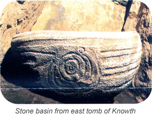 circular city of Atlantis, while I can see an early version of a Babylonian winged disk. In 2005, probably as a promotional ploy, he issued a challenge for an open debate on his theory.
Frank Joseph has related speculative ideas claiming that “the early date for New Grange, its circular construction, sophisticated solar orientation and mythic tradition all point to Atlantean origins.”[0636.70]
Like all ancient monuments, the Boyne Valley cluster has generated its own collection of wild speculation, such as Freddy Silva’s claim that there is a connection between Knowth and Sacsayhuaman near Cuzco in Peru and he also hints at a possible link with Egypt’s Osirion(f)!
Erlingsson has more recently suggested that the ‘sunken’ island referred to by Plato was probably located in the vicinity of the southern end of the North Sea. He proposes that around 6100 BC, a tsunami generated by a massive storegga off Norway reduced the then low-lying Dogger Bank to the impassable muddy shoals recorded by Plato! He has suggested that the original Atlantis narrative, conveyed to Solon, was a mixture of an account of megalithic Ireland and a report of the inundation of Doggerland.
Dr Patrick Wallace, the Director of the National Museum of Ireland, declared that he was unaware of any archaeological evidence to support Erlingsson’s claims.
Nevertheless, Erlingsson has produced some interesting material on the bursting of glacial lakes or what is known in Iceland as jökulhlaups and their possible effect on the ending of the last Ice Age(c).
In 2020, the unaccredited Keystone University in Dublin published two articles on the Ancient Origins website, which drew on the theories of Erlingsson and supported the idea of Atlantis in Ireland(d)(e). The Keystone theory has been developed into a book[1775] by Anthony Woods.
(a) Wayback Machine (archive.org)
(b) USSR Planned to Invade Sweden (archive.org) (halfway down page)
(c) Explanation of Bølling by jökulhlaup (archive.org)
(d) https://www.ancient-origins.net/unexplained-phenomena/atlantis-ireland-0013940
(e) https://www.ancient-origins.net/unexplained-phenomena/ireland-atlantis-0013941