Latest News

Joining The Dots
I have now published my new book, Joining The Dots, which offers a fresh look at the Atlantis mystery. I have addressed the critical questions of when, where and who, using Plato’s own words, tempered with some critical thinking and a modicum of common sense.Read More »
Norway
Pytheas
Pytheas was a 3rd century BC navigator from the Greek colony of Massalia (Marseilles) and is best known for his voyage in the North Atlantic, possibly around 240 BC. His trip took in the British Isles and as he ventured further North and claimed to have reached Thule.
>Gregory Douglas Wear, in his study of early excursions by Mediterranean peoples into the North Atlantic concluded that with the current state of archaeological and historical research, it is nothing less than impossible to verify with certainty, whether Greeks, Phoenicians, Carthaginians or any other pre-Pythean Mediterranean dweller actually set foot on the British Isles, northern France, or anywhere else in north-western Europe north of Galicia(c).<
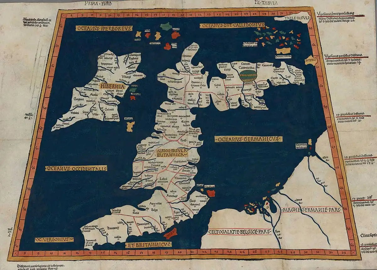
Thule has generated volumes of debate regarding its location. Pytheas described Thule as lying six days’ sail to the north of Britain. Iceland, Norway(a) and the Faroes along with the Scottish Shetland and Orkney Islands have all been proposed as Pytheas’ Thule.
Søren Tillisch, a Danish archaeologist, accepts that the identification of the Faeroes as the Thule of Pytheas is reasonable, but he still thinks that the Estonian island of Saaremaa in the Baltic is also a feasible candidate(b).
Rhys Carpenter devoted an interesting chapter of his Beyond the Pillars of Hercules[221] in which he suggested that Pytheas’ voyage was undertaken with commercial objectives in mind, but on that level it was unsuccessful. However, as a voyage of discovery, it was an unparalleled achievement, earning for Pytheas Carpenter’s accolade of ”antiquity’s Greatest Explorer”.
Carpenter favours the idea that the term, ‘Pillars of Hercules’, when applied to the Strait of Gibraltar was used with the sense of boundary markers, indicating ”the limits of the Inner Sea that, for the Greeks, was the navigable world.”[p156]
(a) (99+) (PDF) Pytheas of Massalia’s Route of Travel | Cameron McPhail – Academia.edu
(b) (99+) (DOC) Pytheas of Massalia and the Baltic lecturewpictures | Søren Tillisch – Academia.edu
Speculum Regale, The (L)
The Speculum Regale (The King’s Mirror)(a) was written in Norway around 1250 AD. Bramwell notes that in it, Ireland was identified with Atlantis[195.181].
Bramwell was mistaken, referring to a land-under-the-waves (Tir fo thuinn) which is a term sometimes applied to Hy-Brasil a mythical sunken land to the west of Ireland.
(a) https://www.archive.org/stream/kingsmirrorspecu00konuuoft/kingsmirrorspecu00konuuoft_djvu.txt
Thule
Thule is the name given in ancient Greek and Roman literature for the most northerly part of the world. Around 300 BC the Greek navigator Pytheas claimed to have visited Thule, six days of travel beyond Northern Britain. This may have been Iceland and in support of this idea, a paper was submitted to the 2008 Atlantis Conference in Athens by two Italian researchers, G. Giancarlo and M. Stucchi. In Germanic and Scandinavian traditions the name is applied to a long-lost continent in the North Atlantic.
The Thule-in-Iceland theory has the support of the renowned Professor of European Archaeology, Barry Cunliffe, author of The Extraordinary Voyage of Pytheas the Greek [2081].
The archaeologist, Rhys Carpenter, in a study of Pytheas‘ travels in the North Sea, concluded that the Shetland Islands should be identified as Thule shown on Ptolemy’s map just north of the Orkneys, He argues that “it is an unchallengeable inference that Ptolemy’s data for the location of Thule must go back to Pytheas since no one else in late antiquity ever claimed to have visited that remote region.” [221.183]
Another candidate is the Estonian island of Saaremaa(d), which is also home to the Kaali meteor craters. This meteorite “was a coarse octahedrite, with surviving fragments being only a few grams in weight. Despite the intensity of investigation both inside the craters and outside in nearby peat bogs, the actual date of the impact has been estimated at four widely spaced times: 6400 BC based on microspherules in peat (Raukas 2000); 5000 BC on similar evidence (Tiirmaa and Czegka 1996); 1740–1620 BC based on bulk sediment samples from the near the bottom of the crater lake, or a similar 1690–1510 BC date based on associated terrestrial macrofossils from the deepest part of the lake (Veskiet al. 2004); and 800–400 BC based on peat associated with impact ejecta and iridium in nearby bogs (Veski et al. 2004). Veski and his colleagues argue for the calibrated date range of around 800–400 BC, speculating that the microspherules possibly relate to a separate earlier impact event.”
Felice Vinci is a co-author (with Syusy Blady & Karl Kello) of Il meteorite iperboreo [1906]. in which the Kaali meteor is discussed along with its possible association with the ancient story of Phaeton.
In 2013 Lucio Russo located Thule on the coast of Greenland, having identified errors in Ptolemy’s geographical calculations[1060].
Marin, Minella & Schievenin in The Three Ages of Atlantis [972.375] propose that the island of Thule described by Pytheas was the legendary Hi-Brasil, which in turn they claim was part of the Porcupine Bank that they argue was only ‘recently submerged’.
A 2014 paper(b) by Cameron McPhail addressed the problem of Thule’s location. He “offers a new approach, using information supplied in the fragments of Eratosthenes’ Geography, supports assertions that Pytheas exited the Mediterranean sailing via the Strait of Gibraltar, and that Thule, the most distant locale reached, should be identified with Norway.” and concluded that “The problems of Pytheas’ route of travel cannot all be solved. The two discussed here, on account of the scant primary source information, will remain open to interpretation.“
>Support for a Norwegian Thule received a recent boost when two German investigators from the Technical University of Berlin proposed that the island of Smøla was the Thule of Pytheas. In September 2020, Smithsonian Magazine reprinted an article by F. Salazar from Hakai Magazine(f) outlining this new theory(e).<
A recent article(c) on the National Geographic website noted that “Today, historians aren’t sure if Pytheas’s remote land was based on a real location or whether it is simply a stand-in for any place. Whatever the case, it shows up in the phrase “Ultima Thule”—any extremely remote place on Earth. And the name Thule lives on in Greenland with the Thule Air Force Base; in the Sandwich Islands, one of which is South Thule; and in the name of the 69th element, thulium, discovered by a Swedish chemist.”
(b) (99+) (PDF) Pytheas of Massalia’s Route of Travel | Cameron McPhail – Academia.edu
(d) https://en.wikipedia.org/wiki/Thule
(e) (Smithsonian Sept 8, 2020) This Norwegian Island Claims to Be the Fabled Land of Thule | Travel | Smithsonian Magazine
(f) Hakai Magazine
Storegga
Storegga submarine slides are enormous underwater movements of glacial  sedimentary deposits that were only recently identified. While many of these occurred following the melting of the glaciers at the end of the last Ice Age some more recent movements have also been identified(j). Either earthquakes or the decomposition of gas hydrates is their most likely cause. As many as three storegga have been identified that occurred off the west coast of Norway around 6000-5000 BC(a). The combined volume of material involved in the last two events has been calculated at 1700 cubic kilometres. As a consequence, gigantic tsunamis were generated which flooded a number of landmasses including Scotland.
Ulf Erlingsson suggests that one of these events, around 6100 BC, may have been responsible for the final submergence of the Dogger Bank in the North Sea, creating the impassable muddy shoals mentioned by Plato. This idea, if you’ll forgive the pun, does not hold water, as Plato clearly says that the muddy shoals were still a maritime hazard nearly 6,000 years later when sea levels had risen considerably and could no longer present a navigational barrier.
The dating of these events is discussed by Bernhard Weninger and his associates in a 2008 paper available online(b).
Knut Rydgren and Stein Bondevik of Norway’s Sogn og Fjordane University have concluded that the flooding of Doggerland as a result of the Storegga event took place at the end of autumn(g).
The evidence to date suggests that the flooding of the Black Sea coincided with a storegga event, which would require a catastrophe on a scale not previously considered. In a 2017 paper(e), John M. Jensen offers additional evidence to support this contention.
In 2014, Dr Jon Hill revealed(d) the results of a study of the impact of the 6,200 BC Storegga on the low-lying Doggerland stating that “We were the first ever group to model the Storegga tsunami with Doggerland in place. Previous studies have used modern bathymetry (ocean depth).” The study was commented on further by Axel Bojanowski in Der Spiegel with an English translation on the de Grazia website(f). The scale of the landslide is graphically described there.
Yurii Mosenkis endorses this date proposing that it lay between 6225 BC and 6170 BC(h). Further support for the 6200 BC date can be read in a 2008 paper(i).
In 2015 the UK’s Daily Mail offered further details(c) gleaned from articles in the respected journals Geology and Science Nordic.
A paper published in 2020 by Alaister Dawson et al of Dundee University(l) refers to the studies in the Shetland Isles which indicate that the Storegga Slide tsunami run-up deposits have been identified between 8.1 and 11.8 metres above present sea levels. They add “It should be noted that the position of relative sea level ca 8 ka cited here as 20 m may have been as low as ca 30 m.” This suggests a tsunami of between 30 and 40 metres, which must have been a terrifying spectacle. This paper should be read in conjunction with an earlier paper(k) by Dawson.
(a) https://en.wikipedia.org/wiki/Storegga_Slide
(d) (BBC May 1, 2014) https://www.bbc.com/news/science-environment-27224243
(e) https://www.migration-diffusion.info/article.php?year=2017&id=505
(f) <tsunami submerged doggerland mesolithic paradise under north sea> (archive.org)
(g) https://www.q-mag.org/moss-betrays-the-season-of-the-storegga-event.html
(j) shetland Tsunami hazards (archive.org)
(k) (PDF) The Storegga Slides: Evidence from eastern Scotland for a possible tsunami (researchgate.net)_
(l) https://discovery.dundee.ac.uk/ws/portalfiles/portal/38766820/Dawson_et_al_2019_Sedimentology.pdf
Scheria
Scheria is the name of a Phaeacian island mentioned by Homer in his Odyssey and identified by some, including Ignatius Donnelly, as Atlantis. Scheria has been noted as only second to Atlantis for the array of locations ascribed to it. For example, Heinrich Schliemann, as well as many ancient and modern commentators, considered Scheria to have been Corfu. K. T. Frost in the early part of the 20th century associated Atlantis with Homer’s Scheria and both with the Minoan Empire, an idea also supported by Walter Leaf(l).
Others, such as Felice Vinci suggest Norway, while Iman Wilkens[610] offers the Canaries.
A recent paper by Gerard Janssen, of Leiden University, also places Scheria in the Canaries, specifically on Lanzarote(f). This is one of an extensive series of papers by Janssen, which links Homer’s geography with locations in the Atlantic(g). An introductory paper(h) might be the best place to start.
An Atlantic location for Homer’s epic poems is advocated by N.R. De Graaf, the Dutch author of the Homeros Explorations website(i). Specifically, he also concluded that Scheria can be identified with Lanzarote in the Canaries concurring with Wilkens and Janssen.
According to Pierluigi Montalbano, his native Sardinia was the Homeric land of the Phaeacians(j). Massimo Pittau offered the same conclusion “However the fact is that the Odyssey- as we have seen before – never mentions Sardinia. How, therefore, can this great and singular historical-documentary inconsistency be overcome? It can be overcome by assuming and saying that the poet of the Odyssey actually mentions Sardinia, but not calling it with his name, which will later become traditional and definitive, but with some other name relating to one of its regions or its population. And this is precisely my point of view, the one I am about to indicate and demonstrate: the poet of the Odyssey mentions Sardinia and its Nuragic civilization when he speaks of the «Scherìa or island of the Phaeacians».”(k)
Armin Wolf (1935- ), the German historian, suggests(b) that Calabria in Southern Italy was Scheria and even more controversially that the Phaeacians were in fact Phoenicians!
Wolf also claims[669.326] that although the country of the Phaeacians is in some translations called an island, the original Greek text never calls it ‘island’ just Scheria, which, Wolf informs us, etymologically means ‘continent’ – perfectly fitting Calabria. Even today, when people from Sicily go to Calabria they say they are going to the ‘continente’. Wolf puts Scheria in the vicinity of Catanzaro, the capital of Calabria. It has been suggested to me in private correspondence(d) that the etymology of Catanzaro is strongly indicative of a Phoenician influence! Catanzaro is also  known as ‘the city of the two seas’, having the Tyrrhenian Sea to the west and the Ionian Sea to the east. It is Wolf’s contention that it was across this isthmus that Odysseus travelled[p.327].
A further mystery is that, according to Dr Ernst Assmann quoted by Edwin Bjorkman, “both the vessel of Odysseus, as pictured in Greek art, and the term applied to it, are of Phoenician origin.”
Daniel Fleck(a) lists ten similarities between Scheria and Atlantis. Jürgen Spanuth[015] quoted and added to an even more extensive list of comparisons between the two compiled by R. Hennig. Rainer W. Kühne has also written a paper(c) on the similarities. Walter Leaf perceived a connection between the two and wrote accordingly[434]. Edwin Björkman went further and wrote a book[181] that linked Tartessos, Scheria and Atlantis. More recently, Roger Coghill stressed the similarity of Homer’s Scheria to Plato’s Atlantis in The Message of Atlantis [0494].>>Additional comparisons are offered on the coda.io website(n).<<
Ernle Bradford notes that the name Scheria itself is thought by some to be derived from the Phoenician word ‘schera’, which means marketplace, which is not incompatible with Plato’s description of Atlantis as a hive of commercial activity. [1011.204]
Michael MacRae in his Sun Boat: The Odyssey Deciphered[985] also thinks that Scheria could be identified with Atlantis and as such was probably situated at the western end of the Gulf of Cadiz near Portugal’s Cape Vincent. A number of 20th-century researchers such as Sykes and Mertz have placed the travels of Odysseus in the Atlantic. More recently, Gerard Janssen has followed this school of thought and as part of his theories identifies Scheria as the island of Lanzarote in the Canaries (e).
This identification of Scheria with Atlantis has induced Eberhard Zangger, who advocates Atlantis as Troy, to propose that Troy is also Scheria![483]
However, Ernle Bradford, who retraced the voyage of Odysseus, voiced his view that Corfu was the land of the Phaeacians and noted that “the voice of antiquity is almost as unanimous about Scheria being Corfu as it is about the Messina Strait being the home of Scylla and Charybdis.”
A paper by John Black concluded with the following paragraph that fairly sums up what we actually know about the Phaeacians. “Who were the Phaeacians and where was their place of abode? No definite answers and no clues have been found but yet their extraordinary seafaring abilities and the intriguing description by Homer make them appear to be either a fascinating advanced civilization of the past yet to be discovered, or a fiction of the imagination for the sake of a good story. It is worth mentioning that Homer’s description of Troy was also once considered to be a work of fiction. However, the city of Troy has now been discovered, turning myth into reality.” (m)
(a) http://web.archive.org/web/20250613012321/https://atlantipedia.ie/samples/archive-2087/
(b) Wayback Machine (archive.org)
(c) (PDF) Did Ulysses Travel to Atlantis? (researchgate.net)
(d) Private correspondence Jan. 2016
(e) https://www.homerusodyssee.nl/id16.htm
(f) https://www.academia.edu/38347562/ATLANTIC_SCHERIA_AND_THE_FAIAKANS_LANZAROTE_AND_THE_FAYCANS
(g) https://leidenuniv.academia.edu/GerardJanssen
(h) https://www.academia.edu/38537104/ATLANTIC_TROY
(i) https://www.homeros-explorations.nl
(k) Massimo Pittau – The Odyssey and Nuragic Sardinia (www-pittau-it.translate.goog)
(l) Miscellanea Homerica, VI, The Classical Journal, Vol. 23, No. 8 (May, 1928), pp. 615-617 (3 pages)
(m) https://www.ancient-origins.net/myths-legends/mythic-scheria-and-legendary-phaeacians-001034
(n) https://coda.io/@together/collective-research/homers-oddysey-atlantis-comparison-14 *
Phaeacia
Phaeacia was a land described by Homer in his epic poem Odyssey, which is usually equated with the legendary island of Scheria, identified by many with Atlantis. .
Ignatius Donnelly was probably the first to suggest a linkage between Phaeacia and Atlantis. Jürgen Spanuth as well as Hennig and Kluge shared this view of Donnelly‘s, Based on Hennig’s work Spanuth listed 32 items of similarity between Phaeacia and Atlantis in his Atlantis – The Mystery Unravelled[017.143] and Atlantis of the North[015.218]. However, N. Zhirov remarked that an equally long list of discrepancies could also be compiled, leaving the question still open.
There is something of a consensus among scholars that Phaeacia is a reference to the Greek island of Corfu. However, Hennig did not accept that Scheria could be identified with the Adriatic island, instead, he suggested that it was beside Spain.
An Atlantic location for Homer’s epic poems is advocated by N.R. De Graaf(d), the Dutch author of the Homeros Explorations website(c). Specifically, he concluded that Scheria can be identified with Lanzarote in the Canaries concurring with Iman Wilkens.
Armin Wolf who has studied extensively the geography of Homer’s Odyssey concluded a paper(b) on the subject as follows – “Scheria, the country of the Phaeacians, this ideal land described by Homer, was no fantasy, but nothing else but Greater Greece, Magna Graecia.”
However, Felice Vinci, has strongly set Phaeacia in the geographical context of Norway [019.21-4] and offers a number of similarities between the Vikings and the Phaeacians. Kalju Pattustaja agrees with this identification of the Phaeacians(e) and cites Andres Pääbo as being of a similar view. However, it should be noted that Pääbo is highly critical of much of Vinci’s work(f).
Roger Coghill is a more recent supporter of Scheria being another name for Atlantis, which he locates near Faro in Portugal.(g) His views have been contrasted in the media(a) with those of Peter Daughtrey, who locates Atlantis not too far away in Silves.
(a) https://web.archive.org/web/20190803175205/https://meravista.com/en/blogentry/legendary-city-atl
(b) Wayback Machine (archive.org)
(c) Homeros Explorations – Homer, facts or fiction? (homeros-explorations.nl)
(d) Homer, facts or fiction? | ancient america
(e) (81) K.Pattustaja. THE NORDIC ORIGIN OF THE MYCENAEAN CIVILIZATION – THE FORGOTTEN FINNIC ROOTS (academia.edu)
(f) http://web.archive.org/web/20210101092152/http://www.paabo.ca/reviews/BalticHomericVinci.html
(g) http://web.archive.org/web/20250429221554/https:/atlantipedia.ie/samples/archive-2086/