Latest News

Joining The Dots
I have now published my new book, Joining The Dots, which offers a fresh look at the Atlantis mystery. I have addressed the critical questions of when, where and who, using Plato’s own words, tempered with some critical thinking and a modicum of common sense.Read More »
Magna Graecia
Central Mediterranean
The Central Mediterranean is a very geologically unstable region, containing as it does all of Europe’s land-based active volcanoes(a), regular seismic(b) activity with the attendant risk of tsunamis. It is now estimated that a devastating tsunami will hit the Mediterranean every 100 years(c). While the Aegean region experiences the greatest number of earthquakes, the Central Mediterranean, particularly around Sicily, is also prone to regular tremors.
The idea that Atlantis was situated in this region is advocated by a number of researchers, including Alberto Arecchi, Férréol Butavand, Anton Mifsud, Axel Hausmann, as well as this compiler. Plato unambiguously referred to only two places as Atlantean territory (Crit.114c & Tim 25b) North Africa and Southern Italy as far as Tyrrhenia (Tuscany) plus a number of unspecified islands.
The area between Southern Italy and Tunisia has had a great number of sites proposed for the Pillars of Herakles, while possible locations for Gades are on offer, with a number places still known today by cognates of that name.
Plato clearly includes continental territory as part of the Atlantean domain as well as a number of important islands. Within a relatively small geographical area, you have two continents, Africa and Europe, represented by Tunisia and Italy respectively, as well as the islands of Sicily, Sardinia, Corsica and Malta, together with a number of smaller archipelagos, matching Plato’s description exactly. The later Carthaginian Empire also occupied much of the same territory apart from eastern Sicily and southern Italy which by then was controlled by the Greeks and known as Magna Graecia.
For me, the clincher is that within that region, we have the only place in the entire Mediterranean to have been home to elephants up to Roman times – Northwest Africa.
(a) https://en.wikipedia.org/wiki/Volcanology_of_Italy
(b) The Europeam Mediterranean Seismic Centre – EMSC, records all activity in the region.
(c) Tsunami Alarm System – A3M Tsunami Alarm System (tsunami-alarm-system.com) (German & English)
Pythagoras
Pythagoras (c570 – c495 BC) was a Greek philosopher and mathematician and probably best known today for the theorm relating to right-angled triangles that is named after him. However, it has been shown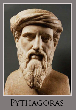 that it was known at least a thousand years earlier in Egypt, Babylon and China(a).
In 2021, Dr Daniel Mansfield, a mathematician at the University of New South Wales, discovered that a 3,700-year-old Babylonian clay tablet illustrates the use of what we call ‘Pythagorean triples’ in dividing land, 1,100 years before Pythagoras!(g)
Although born in Samos he eventually moved to Croton in Magna Graecia, now southern Italy. There, he established a quasi-religious sect of what were in effect were number worshippers.
Wikipedia notes(c) that “Aristotle claimed that the philosophy of Plato closely followed the teachings of the Pythagoreans, and Cicero repeats this claim: Platonem ferunt didicisse Pythagorea omnia (“They say Plato learned all things Pythagorean”). Bertrand Russell, in his A History of Western Philosophy, contended that the influence of Pythagoras on Plato and others was so great that he should be considered the most influential of all Western philosophers.”
Mark Adams, in his Meet Me in Atlantis[1070] has touched on the possible Pythagorean influence on Plato’s use of numbers in his Dialogues. With this in mind, Adams visited the late Ernest G. McClain, the author of a highly original idea, namely that details contained in Plato’s Atlantis story can be explained in terms of mathematical/musical theory. This was expressed in his 1978 book, The Pythagorean Plato[1082], which can be read online(b), but, be warned, most will find this very technical offering rather heavy going.
In 2010, Dr. Jay Kennedy, an American at the University of Manchester, also claimed to have found evidence of Pythagorean influence in Plato’s dialogues, claiming that they contain a regular mathematical structure which relates them to an ancient 12-note musical scale. “Kennedy’s breakthrough, published in the journal Apeiron this week, is based on stichometry: the measure of ancient texts by standard line lengths. Kennedy used a computer to restore the most accurate contemporary versions of Plato’s manuscripts to their original form, which would consist of lines of 35 characters, with no spaces or punctuation. What he found was that within a margin of error of just one or two percent, many of Plato’s dialogues had line lengths based on round multiples of twelve hundred.”(e) A critique(f) of Kennedy’s theory, by Professor Andrew Gregory of University College London, should be read for balance.
An example of Plato’s regard for specific numbers is his idea that 5,040 is a perfect number and is the ideal population for a polis (city). It is a number divisible by all integers from 1 to 10, which would have had even greater significance prior to the invention of decimals. Some of the other factoids claimed for this number are really scary or at least thought-provoking(d).
(a) https://www.storyofmathematics.com/greek_pythagoras.html
(b) Wayback Machine (archive.org)
(c) https://en.wikipedia.org/wiki/Plato#Plato_and_Pythagoras
(d) https://joedubs.com/5040-the-perfect-number/
(e) https://www.theguardian.com/world/2010/jun/29/plato-mathematical-musical-code
Magna Graecia
Magna Graecia is the term applied to those parts of southern Italy and  Sicily colonised by the Greeks, beginning as early as the 8th century BC. An interesting fact is that Philo of Alexandria (20 BC-50 AD) in his On the Eternity of the World(b) wrote: “Are you ignorant of the celebrated account which is given of that most sacred Sicilian strait, which in old times joined Sicily to the continent of Italy?” (v.139). The name ‘Italy’ was normally used in ancient times to describe the southern part of the peninsula(d). Some commentators think that Philo was quoting Theophrastus, Aristotle’s successor. This would push the custom of referring to Italy as a ‘continent’ back to the time of Plato. More recently, Armin Wolf (1935- ), the German historian, when writing about Scheria relates(a) that “Even today, when people from Sicily go to Calabria (southern Italy) they say they are going to the “continente.” This continuing usage is confirmed by a current travel site(c). I suggest that Plato used the term in a similar fashion and can be seen as offering a more rational explanation for the use of the word ‘continent’ in Timaeus 25a, adding to the idea of Atlantis in the Central Mediterranean.
Giuseppe Palermo, in his 2012 book Atlantide degli italiani is now bravely promoting the idea that Plato’s Atlantis was originally located beneath the town of Acri and the surrounding region of Calabria. He supports his claim by matching measurements provided by Plato with physical features around Acri(e). However surprising this idea may seem, it should be pointed out that according to Plato, Atlanteans had occupied southern Italy as far north as Tyrrhenia (Timaeus 25b & Critias 114c). If all this is not true, as a second prize, Acri can at least claim to be the birthplace of the famous American bodybuilder, Charles Atlas!
The Greeks began their gradual expansion westward between the 9th and 6th centuries BC, a development clearly illustrated on an excellent series of online maps(h). Understandably, they would have taken the shortest route from the Greek mainland to the heel of Italy and later on to Sicily. As they progressed with their colonisation, new limits were set, and in time, exceeded. I suggest that these limits were each in turn designated the ‘Pillars of Heracles’ as they expanded. I speculate that Capo Colonna (Cape of the Column) in Calabria may have been one of those boundaries.
Interestingly, 18th-century maps show up to five islands near the cape which are no longer visible(g), suggesting the possibility that in ancient times they could have been even more extensive, creating a strait perhaps matching Plato’s description. On the other hand, the Strait of Messina was one of the locations recorded as the site of the ‘Pillars’. Considering that mariners at that time preferred to hug the coast, I would opt for the Strait of Messina rather than the more frequently proposed Strait of Sicily. A strait is defined as a narrow sea passage, a description that seems inappropriate for the 96 miles separating Sicily from Tunisia.
For a brief history of the rise and fall of Magna Graecia, have a look at the classical wisdom website(f).
It is also noteworthy that there are a number of towns in Calabria where ancient Greek is still spoken(i). Similarly, back on the Peloponnese, the language of Sparta, Tsakonika, is still spoken by about 2,000 people in an area limited to 13 towns, villages and hamlets, located around the village of Pera Melana(j).
(a) Wayback Machine (archive.org)
(b) http://www.earlychristianwritings.com/yonge/book35.html
(c) Four Ways to Do Sicily – Articles – Departures (archive.org)
(d) article Name of Italy (profilbaru.com)
(e) https://www.atlantid.info/?page_id=539
(f) See: https://web.archive.org/web/20180824200049/https://classicalwisdom.com/magna-graecia-greater-greece/
(g) https://www.academia.edu/1152285/Discovery_of_Ancient_Harbour_Structures_in_Calabria_Italy_and_Implications_for_the_Interpretation_of_Nearby_Sites
(h) See: https://web.archive.org/web/20141105204103/https://learningobjects.wesleyan.edu/greek_colonies/
(i) http://www.madeinsouthitalytoday.com/mysterios-places.php
(j) (BBC Dec.16, 2020) BBC – Travel – The last speakers of ancient Sparta
Strait of Sicily
 The Strait of Sicily is the name given to the extensive stretch of water between Sicily and Tunisia. Depending on the degree to which glaciation lowered the world’s sea levels during the last Ice Age; three views have emerged relating its possible effect on Sicily during that period:
(i) Both the Strait of Messina to the north, between Sicily and Italy together with the Strait of Sicily to the south remained open.
(ii) The Strait of Messina was closed, joining Sicily to Italy, while the Strait of Sicily remained open.
(iii) Both the Strait of Messina and the Strait of Sicily were closed, providing a land bridge between Tunisia and Italy, separating the Eastern from the Western Mediterranean Basins.
I find it strange that what we call today the Strait of Sicily is 90 miles wide. Now the definition of ‘strait’ is a narrow passage of water connecting two large bodies of water. How 90 miles can be described as ‘narrow’ eludes me. Is it possible that we are dealing with a case of mistaken identity and that the ‘Strait of Sicily’ is in fact the Strait of Messina, which is narrow? Philo of Alexandria (20 BC-50 AD) in his On the Eternity of the World(a) wrote “Are you ignorant of the celebrated account which is given of that most sacred Sicilian strait, which in old times joined Sicily to the continent of Italy?” (v.139). Some commentators think that Philo was quoting Theophrastus, Aristotle’s successor. The name ‘Italy’ was normally used in ancient times to describe the southern part of the peninsula(b).
Armin Wolf, the German historian, noted(e) that “Even today, when people from Sicily go to Calabria (southern Italy) they say they are going to the “continente.” I suggest that Plato used the term in a similar fashion and was quite possibly referring to that same part of Italy which later became known as ‘Magna Graecia’. Robert Fox in The Inner Sea[1168.141] confirms that this long-standing usage of ‘continent’ refers to Italy.
It is worth pointing out that the Strait of Messina is sometimes referred to in ancient literature as the Pillars of Herakles and designates the sea west of this point as the ‘Atlantic Ocean’. Modern writers such as Sergio Frau and Eberhard Zangger, among others, have pointed out that the term ‘Pillars of Herakles’ was applied to more than one location in the Mediterranean in ancient times.
The Strait of Messina is frequently associated with the story of Scylla & Charybdis, which led Arthur R. Weir in a 1959 article(d) to refer to ancient documents, which state that Scylla & Charybdis lie between the Pillars of Heracles.
In 1910, the celebrated Maltese botanist, John Borg, proposed[1132] that Atlantis had been situated on what is now submerged land between Malta and North Africa. A number of other researchers, such as Axel Hausmann and Alberto Arecchi, have expressed similar ideas.
The Strait of Sicily is home to a number of sunken banks, previously exposed during the Last Ice Age. As levels rose most of these disappeared, an event observed by the inhabitants of the region at that time. The MapMistress website(c) has proposed that one of these banks was the legendary Erytheia, the sunken island of the far west. The ‘far west’ later became the Strait of Gibraltar but for the early Greeks it was the Central Mediterranean.
(a) https://web.archive.org/web/20200726123301/http://www.earlychristianwritings.com/yonge/book35.html
(d) Atlantis – A New Theory, Science Fantasy #35, June 1959 pp 89-96 https://drive.google.com/file/d/10JTH401O_ew1fs8uhXR9C5IjNDvqnmft/view
>(e) Wayback Machine (archive.org) See Note 5<
Strait of Messina
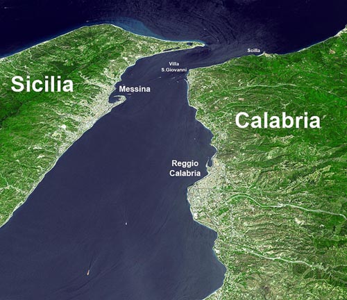
The Strait of Messina is, at its narrowest point, just 2 miles wide. A number of classical writers refer to a time when Sicily was still connected to Italy. In fact legend has it that Heracles was responsible for their separation. However, Cyprian Broodbank has pointed out in his monumental work, The Making of the Middle Sea, that “Today, the Messina strait dividing it (Sicily) from peninsular Italy is a minimum of 3 km (2 miles) wide and 72 metres (235 ft) in depth at its shallowest point. On the face of it, therefore, Sicily and mainland Italy should have fused under full glacial conditions. Yet this spot lies on a plate boundary and has already risen several metres over the last 150 years for which accurate measurements exist. Add a 127,000-71,000-year-old beach now elevated 90m (300ft) above the sea near the strait and we might start to wonder whether Sicily was ever solidly attached to the other land.”[1127.91] Nevertheless, he does suggest that early man possibly had stepping-stones in the form of islets and shallows between the two landmasses.
The Strait of Messina had a reputation in antiquity for having dangerous currents, which are thought to be the inspiration for Homer‘s sea monsters, Scylla and Charybdis. Heinrich Schliemann supported this identification[1243]. The currents there are still very dangerous, but nevertheless the strait is a busy waterway with both commercial and pleasure craft, indicating that the conditions there can be mastered. The hazards were situated at the northern end of the Strait, where today there is a town appropriately called Scilla on the Calabrian side.
The strait is sometimes offered as an earlier site for the Pillars of Heracles prior to the Western Mediterranean becoming more frequently navigated by the ancient Greeks, at which time the term was transferred to the Strait of Gibraltar. Winfried Huf is a keen supporter of ‘Pillars’ having been located at Messina. A constituent part of the Western Mediterranean was the Tyrrhenian Sea, which, for the Greeks, would have been most easily accessed through the Strait of Messina.
The earliest westward expansion of the Greeks was understandably to what became known as Magna Graecia in Sicily and southern Italy. The Phoenician expansion was along the north African coast eventually establishing Carthage at the Strait of Sicily. The ships available at that time were not designed for the open sea, but were usually kept within sight of land. I am inclined to think that the early Greeks would have had the Strait of Messina as the location of their Pillars of Heracles leading to the little known Western Mediterranean (or Tyrrhenian Sea), apparently referred to by some as the ‘Atlantic Sea’, whereas the Strait of Sicily might have led to conflict with the Phoenicians!
It is interesting that from around 330 BC and for nearly a thousand years(b) the Strait of Messina was known as Fretum Siculum, which translates as the Sicilian Strait. Philo of Alexandria (20 BC-50 AD) in his On the Eternity of the World(c) wrote “Are you ignorant of the celebrated account which is given of that most sacred Sicilian strait, which in old times joined Sicily to the continent of Italy?” (v.139).
>Alexander V. Podossinov in his paper on straits and their significance for the ancients commented “the Carthaginians for a long time did not permit the Greeks to pass through the Straits of Messina and had power over the whole western Mediterranean.”(d)<
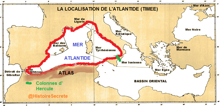
Support for the idea of the Western Mediterranean being the ‘Sea of Atlantis’ with the ‘Pillars’ at the Strait of Messina is presented on a French forum(a), which offers the map below.
(a) https://histoiresecrete.leforum.eu/t716-quelques-questions-se-poser-sur-le-Tim-e-Critias.htm
(b) https://pleiades.stoa.org/places/462494
America
America as the home of Atlantis, took off as an idea shortly after its discovery (or perhaps more correctly, rediscovery) by Columbus. Initially, reports sent back to Europe designated America as ‘Paradise’ 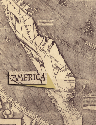
until its identification as Atlantis quickly took hold. John Dee in the time of Elizabeth I was convinced that the newly discovered Americas were in fact, Atlantis, an idea endorsed by Francis Bacon. The first time that America was so named on a map was on the 1507(c) Waldseemüller map, sometimes referred to as “America’s birth certificate.” A rare copy of this map was recently found in Germany(e).
Nevertheless, from the early 1600’s dissenting voices were raised, such as those of José de Acosta and Michel de Montaigne.
As late as 1700, a map of the world by Edward Wells was published in Oxford that highlights the paucity of information regarding the Americas at that time. However, in this instance the accompanying text notes that “this continent with the adjoining islands is generally supposed to have been anciently unknown though there are not wanting some, who will have even the continent itself to be no other than the Insula Atlantis of the ancients.”
For over five centuries, a variety of commentators have associated Atlantis with America and many of its ancient cultures, together with a range of location theories that stretch from Maine through the Caribbean and Central America to Argentina.
Although most proponents of an American Atlantis, particularly following the continent’s discovery, did not specify a location but were happy to consider the Americas in their entirety as Plato’s lost land. In 2019, Reinoud de Jonge published a paper declaring that from 2500-1200 BC, America had been an Egyptian colony. He expanded on this in 2912(l), when he claimed that the American colonies, North and South, had supplied the copper and tin for the Bronze Age of the Mediterranean. For good measure, he threw in a wildly speculative translation of the Phaistos Disk to support these contentions.
Over time attention was more focused on Mesoamerica and the northern region of South America, where the impressive remains of the Maya and Incas led many to consider them to be Atlantean.
North America received minimal attention until the 19th century, when an 1873 newspaper report(i) claimed that there was support from unnamed scientists for locating remnants of Atlantis in the Adirondacks and some of the mountains of Maine! More recently, Dennis Brooks has advocated Tampa Bay, Florida, while John Saxer supports Tarpon Springs, also in Florida as Atlantean. To confuse matters further, Mary Sutherland locates Atlantis in the Appalachian Mountains of Kentucky and for good measure, suggests that King Solomon’s mines are to be found in the same region!
For example, the discovery of the remains of the remarkable cultures of Mesoamerica generated speculation on the possibility of an Atlantean connection there. This view gained further support with the publication of Ignatius Donnelly’s groundbreaking work on Atlantis.
Some have seen an Atlantic location for Atlantis as a conduit between the culture of ancient Egypt and that of Meso-America(d).
Half a century ago, Nicolai Zhirov claimed that Plato had knowledge of America [458.22] indicated by his statement that Atlantis was in a sea with a continent encompassing it. He thought that this was the earliest record of a continent beyond the Atlantic.
However, Plato also said that Atlantis was surrounded ‘on all sides’ by this continent, which is not compatible with the Azores, advocated by Zhirov as the location of Plato’s sunken island. In an effort to strengthen this claim Zhirov also claims that there is evidence that King Sargon of Akkad travelled to America in the middle of the third millennium BC, an idea that has gained little traction.
The idea of Sumerians in America was promoted by A.H. Verrill and his wife Ruth, who claimed [838] that King Sargon travelled to Peru, where he was known as Viracocha. The Verrills support their contention with a range of cultural, linguistic and architectural similarities between the Sumerians and the Peruvians.
More recently, Andrew Collins has promoted the idea of Atlantis in the Caribbean, specifically Cuba. Followers of Edgar Cayce are still expecting the Bahamas to yield evidence of Plato’s island. Gene Matlock supports the idea of a Mexican location with an Indian connection, while Duane McCullough opts for Guatemala. Ivar Zapp and George Erikson have also chosen Central America for investigation. Further south Jim Allen has argued strongly for Atlantis having been located on the Altiplano of Bolivia. A website entitled American Atlantis Research from Edward Alexander , now offline, was rather weak on content and irritatingly referred to the ‘Andies’.
Although much of what has been written about an American location for Atlantis is the result of serious research, it all falls far short of convincing me that the Atlantis of which Plato wrote is to be found there. No evidence has been produced to even hint that any American culture had control of the Mediterranean as far as Tyrrhenia in the north and Libya in the south. No remains or carvings of triremes or chariots have been found in the Americas. How could an ancient civilisation from America launch an attack across the Atlantic and at the furthest end of the Mediterranean 9,000 or even 900 years before Solon? An even more important question is, why would they bother? There is no evidence of either motive, means or opportunity for an attack from that direction.
A number of Plato’s descriptions of Atlantis would seem to rule out America as its location.
(a) As mentioned above, the ‘opposite continent’ referred to by Plato (Timaeus 25a) is described as encompassing the sea in which Atlantis lay. America cannot be described as enclosing the Atlantic. Around 550 AD, Procopius noted that when viewed from the southern side of the Strait of Gibraltar, “the whole continent opposite this was named Europe”(m) (not America)!
(b) The Greeks only knew of three continents, Europe, Asia and Libya. Armin Wolf, the German historian, when writing about Scheria relates(f) that “Even today, when people from Sicily go to Calabria (southern Italy) they say they are going to the “continente.” I suggest that Plato used the term in a similar fashion and was quite possibly referring to that same part of Italy which later became known as ‘Magna Graecia’. Robert Fox in The Inner Sea[1168.141] confirms that this long-standing usage of ‘continent’ refers to Italy.
(c) Herodotus described Sardinia as “the biggest island in the world” (Hist.6.2). In fact Sicily is marginally larger, but as islands were measured in those days (Felice Vinci) [019] by the length of their coastal perimeter, Herodotus was correct. Consequently, it can be argued that since Cuba and Hispaniola are much more extensive than Sardinia, the Greeks had no knowledge of the Caribbean.
(d) Plato makes frequent references to horses in Atlantis. The city itself had a track for horseracing (Critias 117c). The Atlanteans had thousands of chariots (Critias 119a). The Atlanteans even had horse baths (Critias 117b). All these references make no sense if Plato was describing an American Atlantis as there were no horses there for over 12,000 years, when they died out, until brought back by the Spaniards millennia later. Furthermore, it makes even less sense if you subscribe to the early date (9600 BC) for Atlantis as it is thousands of years before we have any evidence for the domestication of the horse, anywhere.
A recent study of worldwide DNA patterns suggests that “no more than 70 people inhabited North America 14,000 years ago.”(b) But a more important claim has been offered by Professors Jennifer Raff and Deborah Bolnick who have co-authored a paper offering evidence(j) that the genetic data only supports a migration from Siberia to America. This certainly runs counter to any suggestion of transatlantic migration from Europe.
In 1900, Peter de Roo put forward the idea that the ancient Greeks had knowledge of America, despite the fact that Herodotus clearly said that only three continents were known to them [Histories 4.42]. A 2013 book, L’America dimenticata [1060], by Italian physicist and philologist Lucio Russo, also claims that the ancient Greeks had knowledge of America and it was gradually forgotten because of mistakes made by Ptolemy including a 15-degree error for the latitude of the Canaries(g).
However, the idea that the Greeks had an awareness of America persists, with some claiming that they had colonies in Canada. Among these are Lucio Russo, Ioannis Liritzis(n) and Minas Tsikritsis(p). Manolis Koutlis has gone one further and claims that not only were there Greek Colonies in Canada, but that Atlantis had been situated in the Gulf of St. Lawrence(o).
In a 2024 paper(q), the controversial Felice Vinci affirmed his belief that there had been a settlement of ancient Greeks in the St. Lawrence region of Canada. He speculates that these settlers set sail from the Gulf of Morbihan in Brittany, where an extraordinary alignment of nineteen gigantic menhirs constituted the Pillars of Herakles!
The late Professor Antonis Kontaratos placed the capital of Atlantis at Poverty Point in Louisiana or it at least inspired some of Plato’s description since “there is also solid evidence that the Greeks were travelling to America in prehistoric times too and could have witnessed firsthand the impressive earthworks at Poverty Point, information which could have reached Plato independently as a fading legend [0750].” Kontaratos cited Plutarch to support his contention of Greek transatlantic travel in prehistory.
I note that there is a suspiciously disproportionate number of Greeks supporting the idea of pre-Columbian Hellenic visitors to America!
While there is extensive debate regarding the Americas being visited by ancient Greeks (Minoans), Phoenicians and even Sumerians, there seems little doubt that America had been visited by various other peoples prior to Columbus, such as Welsh, Vikings or Irish. The case for the latter is strengthened by a 500-year-old report(h) of a long-established Irish colony in North America called Duhare.
America as Atlantis and the source of freemasonry knowledge was recently repackaged in a brief article on the Odyssey website(k) quoting Manly P. Hall who in turn cited Plato and Sir Francis Bacon. It then proceeds to speculate on what lessons the story of this original American Atlantis offers the America of today!
(c) https://en.wikipedia.org/wiki/Waldseem%C3%BCller_map
(d) link between ancient egypt,atlantis and the americas (archive.org)
(f) Wayback Machine (archive.org)
(g) Reconsidering History: Ancient Greeks Discovered America Thousands of Years Ago (archive.org)
(j) https://phys.org/news/2016-01-genetic-ancient-trans-atlantic-migration-professor.html
(k) https://www.theodysseyonline.com/america-as-atlantis
(l) https://www.academia.edu/3894415/COPPER_AND_TIN_FROM_AMERICA_c.2500-1200_BC_
(m) Vandal Wars 1.1.7
(n) https://www.hakaimagazine.com/news/did-ancient-greeks-sail-to-canada/
(q) https://lupinepublishers.com/anthropological-and-archaeological-sciences/pdf/JAAS.MS.ID.000314.pdf
Phaeacia
Phaeacia was a land described by Homer in his epic poem, the Odyssey, which is usually equated with the legendary island of Scheria, identified by many with Atlantis. .
Ignatius Donnelly was probably the first to suggest a linkage between Phaeacia and Atlantis. Jürgen Spanuth, as well as Hennig and Kluge, shared this view of Donnelly‘s, Based on Hennig’s work Spanuth listed 32 items of similarity between Phaeacia and Atlantis in his Atlantis – The Mystery Unravelled[017.143] and Atlantis of the North[015.218]. However, N. Zhirov remarked that an equally long list of discrepancies could also be compiled, leaving the question still open.
There is something of a consensus among scholars that Phaeacia is a reference to the Greek island of Corfu. However, Hennig did not accept that Scheria could be identified with an Adriatic island, instead, he suggested that it was beside Spain.
An Atlantic location for Homer’s epic poems is advocated by N.R. De Graaf(d), the Dutch author of the Homeros Explorations website(c). Specifically, he concluded that Scheria can be identified with Lanzarote in the Canaries concurring with Iman Wilkens.
Armin Wolf who has studied extensively the geography of Homer’s Odyssey concluded a paper(b) on the subject as follows – “Scheria, the country of the Phaeacians, this ideal land described by Homer, was no fantasy, but nothing else but Greater Greece, Magna Graecia.”
However, Felice Vinci has strongly set Phaeacia in the geographical context of Norway [019.21-4] and offers a number of similarities between the Vikings and the Phaeacians. Kalju Pattustaja agrees with this identification of the Phaeacians(e) and cites Andres Pääbo as being of a similar view. However, it should be noted that Pääbo is highly critical of much of Vinci’s work(f).
Roger Coghill is a more recent supporter of Scheria, being another name for Atlantis, which he locates near Faro in Portugal.(g) His views have been contrasted in the media(a) with those of Peter Daughtrey, who locates Atlantis not too far away in Silves.
(a) https://web.archive.org/web/20190803175205/https://meravista.com/en/blogentry/legendary-city-atl
(b) Wayback Machine (archive.org)
(c) Homeros Explorations – Homer, facts or fiction? (homeros-explorations.nl)
(d) Homer, facts or fiction? | ancient america
(e) (81) K.Pattustaja. THE NORDIC ORIGIN OF THE MYCENAEAN CIVILIZATION – THE FORGOTTEN FINNIC ROOTS (academia.edu)
(f) http://web.archive.org/web/20210101092152/http://www.paabo.ca/reviews/BalticHomericVinci.html
(g) http://web.archive.org/web/20250429221554/https:/atlantipedia.ie/samples/archive-2086/