Alfred Wegener
Expanding Earth Hypothesis *
The Expanding Earth Hypothesis.
For thousands of years, it was accepted that the surface of the earth was in a static state. This belief persisted until the rediscovery of America in 1492 and the cartographic improvements during the following century before Abraham Ortelius in his 1596 Thesaurus Geographicus[1225] proposed that the Americas had once been joined to Europe and Africa. It is often claimed that in 1620 Francis Bacon commented on the close fit of eastern South America with the west coast of Africa, however, this, according to G.L. Herries Davies, is an exaggerated interpretation of what he actually said(o).
A number of others concurred with the jig-saw suggestion until 1858 when the French geographer Antonio Snider-Pellegrini offered[0555] a theory of crustal movement that was more fully developed in 1912 by Alfred Wegener, which he came to label ‘continental drift’(e). Snider-Pellegrini also thought that the Earth had been much smaller at the time of the biblical Genesis(ac)! The big objection to the theory was a lack of a convincing mechanism to explain it(f).
 A number of writers have attempted to bring the theory of Continental Drift (CD) into the Atlantis debate. They seem to overlook the fact CD was proposed as a very very slow process, while Plato describes the demise of Atlantis as occurring in a single day and a night.
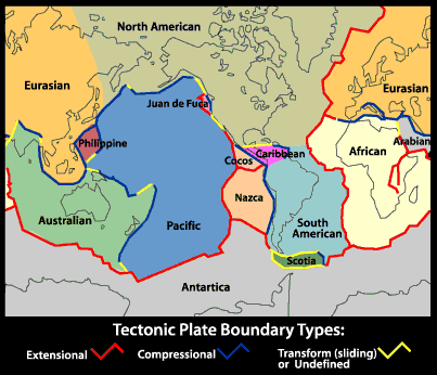
Wegener’s theory was debated until the late 1950’s when it morphed into the theory of Plate Tectonics (PT) following new developments in earth sciences in particular the recognition of seafloor spreading at mid-ocean ridges. However, PT as we know it demands subduction(z), which in itself has created new problems(aa)(ab).
The theory divides the lithosphere into a number of plates that are constantly moving in various directions at rates of a few centimetres a year. Competing with PT in the early years was the theory of Earth Crustal Displacement advocated by Charles Hapgood which claims that the entire crust of the earth moved as a unit. Endorsed by Albert Einstein it is fundamental to the theory of an Antarctic location for Atlantis proposed by Rose & Rand Flem-Ath.
Unfortunately, Plate Tectonics does not explain everything and ever since it gained the pre-eminence it currently enjoys, various writers have questioned what they perceive as its shortcomings(g)(h)(i).
A totally different proposal is that the earth is expanding. Although the concept did not get much attention until the 1980’s there are antecedents stretching back to 1888(a), when the earliest suggestion was made by the Russian, Ivan Yarkovsky (1844-1902). A year later the Italian geologist (and violinist) Roberto Montovani (1854-1933) proposed(I) a similar mechanism. In 1933, Ott Christoph
Hilgenberg(t) published Vom wachsenden Erdbal (The Expanding Earth) [1328].
In 1963, a Russian lady, Kamilla Abaturova, wrote to Egerton Sykes expressing the view that although her theory of an expanding Earth involved a ‘slow’ process, she proposed that at the time of Atlantis’ the radius of the Earth was 600 km shorter(af). In geological terms, this is far from ‘slow’!
The leading proponent of the theory today is arguably the, now retired, geologist Dr James Maxlow(b). A detailed outline of the theory is also offered on his website(c). For laymen like myself, a series of YouTube clips(d) are probably more informative. I have stated elsewhere that I am sympathetic towards the idea of earth expansion finding it somewhat more credible than plate tectonics. The truth of the matter is that since Ortelius first suggested that the continents of our planet had moved, all that has emerged since is a refinement of that basic idea leading to CD which became PT and as the latter still does not answer all the questions it raises, it is clear that further modification will be required. In December 2021, Maxlow published an overview of his current thinking on Expansion Tectonics(ag).
The Expanding Earth Hypothesis may, as its proponents claim, supply all those answers. Others do not think so, which brings me to J. Marvin Herndon who has ‘married’ the theory of an expanding earth with the idea of crustal plates(j) , naming his 2005 concept Whole-Earth Decompression Dynamics (WEDD).
The Thunderbolts.info website has a three-part article seeking to offer “an alternative to plate and extension tectonics”. The anonymous author suggests that an electrical element is involved in the development of our planet. An extensive look at mountain building is also included(y).
A 1998 paper(ah). by Bill Mundy an American Professor of Physics is still relevant. In it, he discusses the pros and cons of both plate tectonics and the expanding earth hypothesis and concluded that “Despite the success that standard plate-tectonics theory has enjoyed, there are phenomena that it currently is not able to model. Perhaps the most adequate model would incorporate Owens’ suggestion that there is both subduction and expansion. This would allow the earth to expand at a modest rate with reasonable changes in surface gravitation and also require some subduction for which the evidence seems convincing. But such a model presents the difficulty of finding suitable mechanisms for expansion, plate motion and subduction!”
In October 2022 Doug Fisher published a paper on Graham Hancock’s website highlighting weaknesses in the generally accepted theory of plate tectonics and seeking a review of the expanding earth hypothesis(ai).
Keith Wilson, an American researcher, has also developed a website(k) devoted to the EEH and linked it to Pole Shift. However, he goes further and introduces Mayan prophecies into the subject, which in my view is unwise in the light of recent events or rather non-events!
In the meanwhile, a number of Atlantis researchers have endorsed the EEH including, Stan Deyo, Georg Lohle and Rosario Vieni. Nicolai Zhirov referred to the growing support both in Russia and elsewhere for the EEH citing a number of its supporters, adding that “the idea of the Earth expanding (within reasonable limits) cannot be ruled out altogether as absurd.”[458.126]
A number of websites have dismissed the EEH as pseudoscience, which is confirmed by satellite measurements(m)(n).
There is also a variation of the standard expansion theory which proposes(q) that expansion may have occurred in fits and starts. There also seems to be evidence that the Earth is not alone with Venus expanding(r) and Mercury contracting(s).
Another matter that may be related to the claim of an expanding Earth is the question of the size of dinosaurs and other creatures and plants millions of years ago, which is claimed to have been impossible if gravity then was the same as today. A book[1218] by Stephen Hurrell has expanded on this idea. There is an interesting website(p) that deals with the enormous size of the dinosaurs as well as other creatures at the same period and the support it may offer the EEH.
Neal Adams, a respected graphic artist(u), is a vocal supporter of the EEH(v), but, he has gone further and has also proposed a growing Moon as well(w). Not content with that, he has extended his expansion investigations to other bodies in our Solar System, such as, Mars, Ganymede & Europa(x). Adams considers the term “Expanding Earth” a misnomer and has named his proposed expansion process ‘pair production’.(ad)
A December 2018 paper by Degezelle Marvin offers some new support for the EEH(ae). The author includes an interesting comparison of the problems of the currently accepted paradigm of plate tectonics with possible solutions offered by EEH. The author concludes with;
“The problems with plate tectonics were presented in this paper. Earth scientists dogmatically follow the plate tectonics theory that is falsified by geological data while Earth expansion is clearly a viable candidate to replace plate tectonics. Analysis map of the age of the oceanic lithosphere showed that the isochrons only ft on a smaller Earth with a calculated radius. Mountain formation has even been presented as a logical result of the Earth’s expansion. The average rate of the growth of the Earth’s radius is 1.22cm/year, obtained by geological methods.”
Finally, I cannot help thinking about those Victorians who thought that they had reached the pinnacle of scientific understanding. They were wrong and, I believe, that so are we, although we are slowly, very slowly, edging towards the truth, which may or may not involve the vindication of the Expanding Earth Hypothesis.
(a) https://www.checktheevidence.co.uk/cms/index.php?option=com_content&task=view&id=394&Itemid=59
(b) https://www.expansiontectonics.com/page2.html
(c) https://www.expansiontectonics.com/page3.html
(d) https://www.youtube.com/watch?v=OUkEu6YYR3s
(e) https://en.wikipedia.org/wiki/Continental_drift
(f) https://www.scientus.org/Wegener-Continental-Drift.html
(g) https://davidpratt.info/ncgt-jse.htm
(h) https://davidpratt.info/lowman.htm
(i) https://www.newgeology.us/presentation21.html
(j) https://web.archive.org/web/20200926204322/http://nuclearplanet.com/
(l) https://en.wikipedia.org/wiki/Roberto_Mantovani
(n) https://blogs.scientificamerican.com/history-of-geology/2014/05/12/the-expanding-earth/
(o) Francis Bacon and Continental Drift (archive.org) *
(p) The Inflating Earth: 4 – Gravity | MalagaBay (archive.org)
(q) https://web.archive.org/web/20161203151134/http://www.xearththeory.com/expansion/
(r) https://web.archive.org/web/20200808000231/https://www.xearththeory.com/expanding-venus/
(s) https://web.archive.org/web/20200807234839/https://www.xearththeory.com/mercury/
(u) https://en.wikipedia.org/wiki/Neal_Adams
(v) https://www.naturalphilosophy.org/site/dehilster/2014/09/22/is-the-earth-expanding-and-even-growing/
(w) Neal Adams: 02 – The Growing Moon | MalagaBay (archive.org)
(x) https://www.youtube.com/watch?v=zy3_sWF7tv4
(y) https://www.thunderbolts.info/forum/phpBB3/viewtopic.php?f=4&t=16534 (link broken Oct. 2019) See: https://atlantipedia.ie/samples/archive-3326/
(z) https://www.thoughtco.com/what-is-subduction-3892831
(aa) https://www.newgeology.us/presentation8.html
(ac) https://www.annalsofgeophysics.eu/index.php/annals/article/view/4622
(ad) https://malagabay.wordpress.com/2015/12/17/neal-adams-01-the-growing-earth/
(ae) https://www.gsjournal.net/Science-Journals/Research%20Papers-Astrophysics/Download/7531
(af) Atlantis, Volume 16, No. 1, February 1963.
(ag) NCGTJV9N4_Pub.pdf (registeredsite.com)
(ah) https://www.grisda.org/assets/public/publications/origins/15053.pdf
(ai) Maps, Myths & Paradigms – Graham Hancock Official Website
Chatwin, C.P.
Charles Panzetta Chatwin (1887-1971) was a British geologist who used the  title The Lost Atlantis for his Presidential Address to the Geological Society on June 9th,1939, defending Lewis Spence and endorsing Wegener’s theory of Continental Drift. He also identified the Atlantic as the home of Atlantis, citing the migratory movements of certain birds and butterflies as evidence for a landmass in that ocean.
It was privately suggested as recently as 2003 that Chatwin had been part of the ‘Piltdown Hoax’.(a)
(a) https://www.bgs.ac.uk/discoveringGeology/geologyOfBritain/archives/piltdownMan/piltdownManTimeLine.html (Link broken Sept. 2020)
Klee, Frederik
Frederik Klee (1808-1864) was a Danish scholar and was a parliamentarian from 1858  until his death. He published his Le Déluge in Copenhagen in 1842 and in Paris[794] in 1847, a work which included many original ideas. He was one of the first to suggest the possibility of an earth axial shift, although in the French edition of his book he discusses the 1844 theory of Baron René de Boucheporn, who also supported the idea of a pole shift. But, Boucheporn followed Carli, attributing it to an encounter with a comet in contrast to Klee’s contention that the cause was internal.
Allan & Delair[014.14] quote Klee as contending ”that certain ancient hieroglyphics refer to a displacement of the heavens at the time of the Deluge.”
Some of Klee’s ideas were ahead of his time and were forgotten until the following century when they were echoed in the work of Wegener and Hapgood.
Full English language biographies of Klee plus excerpts from his book are now available(a)(b).
(a) See: Archive 5144)
(b) https://blog.world-mysteries.com/science/frederik-klee-the-unsung-hero-of-earth-crust-displacement/
Taylor Hansen, Lucile *
Lucile Taylor Hansen (1897-1976) was the daughter of the American geologist Frank Taylor, who suggested a theory of ‘continental drift’ in 1910, before the better known 1912 offering of Alfred Wegener, who cited Taylor. She was a US attorney who published under the name of L. Taylor Hansen. She was one of the earliest female short science fiction writers and had a number of stories published in the late 1920s and 1930s and subsequently wrote a series of articles on scientific mysteries(e). In common with many other female science fiction writers at that time, she denied her gender in order to be taken seriously. She “once titled a letter in Amazing Stories ‘L. Taylor Hansen Defends Himself’ and on another occasion included a photo of a man with one of her stories, claiming it was a photo of herself.”(b) As late as 1963, Egerton Sykes assumed that Taylor-Hansen was male(c).
It was not until later in her life that she privately published her major non-fiction work, The Ancient Atlantic[572]. In this work, she draws on the traditions of the Carib natives of Central America who tell of their ancestors arriving thousands of years earlier from their original island homeland in the east that is now submerged. Some writers have taken this as a reference to Atlantis.
However, we must keep in mind that many islands in the region must have been permanently inundated at the end of the last Ice Age so that unless the tradition also contains references to an abandoned organised urban culture it is unwise to assume any connection with Plato’s tale of Atlantis.
Hansen also discusses, at length (chap. 29), Lake Tritonis (the Triton Sea), which existed in North Africa stretching from the Atlas Mountains to Lake Chad. She relates a story of the discovery in the Middle Ages of a ship near the Drâa Depression in Morocco close to the border with Algeria, which still held the skeletons of its rowers with shackles still on their bones. If true, it would seem to confirm the existence of a substantial inland sea in Africa during the distant past. However, in ancient times most rowers were free men, so I’m forced to consider this report as dubious. Furthermore, the time when she proposes for the existence of the enlarged Lake Tritonis would been before metals, particularly iron, would have been used to make shackles.
The Ancient Atlantic is a large-format wide-ranging book and although now out of print is still to be found in second-hand bookshops or your local library.
Hansen also wrote[573] about a prophet who visited the Indians of North and South America with a strong suggestion that it was Jesus visiting the other sheep that were ’not of this fold’.(d) Her work in this regard has been recently revisited by Sean Casteel(a)
(a) https://medium.com/@timswartz_33663/pale-prophet-or-ancient-alien-887b32162a6a
(b) Women Who Pretended to Be Men to Publish Scifi Books (archive.org) *
(c) Atlantis, Vol.16, No.3, June 1963
(d) https://thegoodlylawfulsociety.org/wp-content/uploads/2016/01/He-Walked-the-Americas.pdf
(e) Summary Bibliography: L. Taylor Hansen (isfdb.org) *
Snider-Pellegrini, Antonio
 Antonio Snider–Pellegrini (1802-1885), was a French geographer, who, in 1858[555], offered a theory(a) that has been seen as a precursor to that of Alfred Wegner’s concept of Continental Drift, which developed into today’s widely accepted model of plate tectonics. It also appears that he,>along with Roberto Montovani(c),<thought that the Earth had been much smaller at the time of the biblical Genesis(c), anticipating the Expanding Earth Hypothesis!
>Snider-Pellegrini published his theories in La Création et ses mystères dévoilés[555], where he is credited with creating the first representation of the Americas joined to Europe and Africa. This is shown below with the ‘before’ image marked ‘Atlantide’ where Brazil is.<
However, it is claimed that as early as 1620, Francis Bacon was one of the first to note the close fit between eastern South America and the west coast of Africa. Half a century ago, this attribution was heavily criticised by G. L. Herries Davies(b), who claimed that the idea came from a ”careless reading of the text.”
Snider-Pellegrini also added the suggestion that Brazil had been the location of Atlantis.
(a) https://web.archive.org/web/20200913123630/https://www.xearththeory.com/
(b) https://www.researchgate.net/publication/238388608_Francis_Bacon_and_Continental_Drift
(c) https://www.annalsofgeophysics.eu/index.php/annals/article/view/4622
Bacon, Sir Francis
Sir Francis Bacon (1561-1626) was born in London and died at Highgate. Bacon was a statesman, philosopher and essayist and he is also frequently referred to as the father of modern science. Although he was not a great scientist, his promotion of the Inductive Method(a) of reasoning did help scientific  advancement.
He was a lawyer and later a judge. In 1621 he was accused of taking bribes, a practice common among judges of the day. He confessed to some of the charges, but because he had the support of King James I, the fine of £40,000 was remitted.
In 1626, Bacon published The New Atlantis(c), generally accepted as a political fable, in which he located his fictional Atlantis off the west coast of America. In the same book he also describes a number of later inventions which probably also makes Bacon the first science fiction writer. However, David Hatcher Childress claims[620.221] that Bacon believed that ‘North Africa and the coast of Morocco’ to be Atlantis, but unfortunately provides no source or reference.
Bacon, who also received some land in America, has been linked with the strange Oak Island Mystery, regarding which it has been suggested that he had hidden there evidence of his authorship of Shakespeare’s plays! Both Ignatius Donnelly and Comyns Beaumont were supporters of this Baconian Hypothesis.
It is sometimes inaccurately(b) claimed that in 1620 Bacon also commented on the close fit of the South American continent with the outline of West Africa, presaging the inspiration behind Snider-Pellagrini and Alfred Wegner’s continental drift.
(a) https://en.wikipedia.org/wiki/Inductive_reasoning
(b) https://www.researchgate.net/publication/238388608_Francis_Bacon_and_Continental_Drift
(c) https://sacred-texts.com/utopia/tna/index.htm
Atlantic Ocean *
The Atlantic Ocean as defined by modern geography stretches between the Poles and is bounded on the west by the Americas and on the east by Europe and Africa. The word ocean is taken from the Greek ‘Okeanos’ which in turn has been suggested to have a Phoenician origin. Okeanos or ‘ocean river’ is first mentioned in Homer’s Iliad, a term that was employed by many ancient writers to refer to an ocean that they believed encircled the then-known world.
As a slight digression, I should mention that ‘Okeanos Potamos’ is an old name for the River Danube, a fact woven into Densusianu‘s theory of a Romanian Atlantis.
It seems that ‘Atlantic sea’ was a term first used by the poet Stesichorus (630-555 BC)(h), about two hundred years before Timaeus was composed by Plato and coinciding with the time of Solon’s famous visit to Egypt, to describe the seas beyond the Pillars of Heracles (Histories I. 202). If this is correct, then we must ask what term was used prior to Herodotus? If it was Okeanos, what body of water, if any, did the term ‘Atlantic’ apply to at the earlier period?. There have been suggestions that the word referred to the western Mediterranean.
Jacques R. Pauwels in his Beneath the Dust of Time[1656] maintains that contrary to popular belief “The Atlantic Ocean does not owe its name to these mountains, as we are often told; on the contrary, they received the name Atlas because they were situated near the Ocean and, like the Okeanos, conjured up the end of the (inhabited) world, the Oikoumene, and separated the earth from the heavens.”
George Sarantitis has proposed that the term used by Plato, Atlantikos Pelagos, can be more legitimately interpreted as ‘Atlantean archipelago’!(d)
However, some researchers, such as Alberto Arecchi(f), have asserted that the name was given to a very large inland sea in what is now North Africa bound by the Atlas Mountains. Jean Gattefosse was a leading exponent of this during the first half of the 20th century.Sarantitis has expanded on this idea, proposing(c) a vast network of huge inland lakes and waterways in what is now the Sahara, which has, in his view, allows a more acceptable interpretation of Hanno’s voyage. Others such as Diodorus (3.38), as late as the 3rd century BC, used the term ‘Atlantic’ to describe the Indian Ocean. It is quite clear that ancient geographical names did not always have the same meanings that they do today.
The confusion does not end there as some ancient writers have identified the Strait of Sicily as the location of the Pillars of Heracles and the waters of the Western Mediterranean as the Atlantic, with some identifying Tyrrhenia as being in the Atlantic.
Most important of all are the comments of Plato himself who refers to the Atlantic in Timaeus (24e) when Atlantis existed noting that ‘in those days the Atlantic was navigable’, implying that in his own time it was not. Consequently, he could not have been referring to the body of water that we know today as the Atlantic. Furthermore, Aristotle seemed to echo Plato when he wrote(e) that “outside the pillars of Heracles the sea is shallow owing to the mud, but calm, for it lies in a hollow.” This is not a description of the Atlantic that we know, which is not shallow, calm or lying in a hollow and which he also refers to as a sea not an ocean. So, what sea was he referring to?
Since other seas have been called Atlantic, we are therefore forced to consider possible alternatives that are also compatible with the other known features of Atlantis. The three leading candidates are
(i) the Western Mediterranean,
(ii) the Tyrrhenian Sea (which is part of the Western Mediterranean) and
(iii) the inland sea in North Africa, sometimes referred to as Lake Tritonis, favoured by Arecchi, Sarantitis and others.
I am personally inclined towards the Tyrrhenian Sea.
Pliny the Elder writing in the first century AD mentions a number of islands in what we now accept as the Atlantic Ocean. These include the Cassiterides (Britain), the Fortunate Isles (the Canaries), the Hesperides, the Gorgades and an island ‘off Mount Atlas’ named Atlantis. Understandably, Pliny’s comments have led to extensive controversy, particularly the identification of the island off Mount Atlas.
In fact, there is even some dispute about the location of the Mount Atlas in question, as there were a number of peaks known by that name in ancient times. Richard Hennig is cited by Zhirov[458.58] as describing the ‘utter confusion’ among ancient authors regarding the location of Mount Atlas.
Ignatius Donnelly was convinced that Atlantis had been situated in the Atlantic opposite the entrance to the Mediterranean. His theories predominated for over half a century and are still popular today. The late Gerry Forster, a British writer, has a 50-page paper supporting Donnelly’s contention posted on his website entitled The Lost Continent Rediscovered(a).
In order to add scientific credibility to Donnelly’s views the discovery of the Mid-Atlantic Ridge was offered as confirmation of the existence of Atlantis as parts of the ‘ridge’ would have been exposed when ocean levels were hundreds of feet lower during the last Ice Age. Today, the Canaries and the Azores are just remnants of what were once larger landmasses.
When Alfred Wegener advanced the theory of Continental Drift, later replaced by that of Plate Tectonics, was first presented, some atlantologists assumed that a mechanism for the disappearance of Atlantis in the Atlantic had been found. However, when the slow rate of movement was fully realised, the theory also sank as an explanation for the demise of Atlantis.
In April 2009 the media burst into one of its occasional ‘Atlantis found’ phases, when it was reported that evidence of an underwater city had been identified 600 miles west of the Canary Islands using Google Earth. The co-ordinates were given as 31 15’15.53N and 24 15’30.53W.
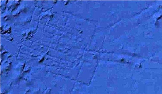 The site appeared to show a grid-like street system, which was estimated to be the size of Wales – a highly improbable, if not impossible size for a Bronze Age city. Apart from which, what appeared to be ‘streets’ would have been kilometers in width. Google responded with the following explanatory statement:
“what users are seeing is an artifact of the data collection process. Bathymetric (sea-floor) data is often collected from boats using sonar to take measurements of the sea-floor. The lines reflect the path of the boat as it gathers the data.” It did not take long before one commentator suggested that this statement was a cover-up.
By early February 2012, Google had corrected what they called ‘blunders’ contained in the original data, which in turn removed the anomalous image(b). No doubt conspiracy theorists will have their appetites whetted by this development.
Nine years later, on April 3, 2018(g), the UK’s Express regurgitated the same story!
As usual, people will believe what they want to believe.
(a) Wayback Machine (archive.org) *
(b) https://www.pcworld.com/article/249339/google_pulls_atlantis_from_google_earth.html
(c) The Peninsula of Libya and the Journey of Herodotus – Plato Project (archive.org)
(d) The Importance of Accurate Translation – Plato Project (archive.org)
(e) Meteorologica : Aristotle : Free Download, Borrow, and Streaming : Internet Archive 354a *
(f) https://www.liutprand.it/Atlantis.pdf
(h) https://www.loebclassics.com/view/stesichorus_i-fragments/1991/pb_LCL476.89.xml
Plate Tectonics
Plate Tectonics is the name given to the widely accepted geological theory that explains the observable fact of continental drift. Abraham Ortelius, a 16th-century cartographer was one of the first to suggest that Africa, Europe and the Americas had at one time been joined together. In the 17th century Sir Francis Bacon is claimed to have been similarly struck by the complementary profiles of South America and Africa, but this, according to G.L. Herries Davies, is an exaggeration of what Bacon actually wrote(j). Alexander von Humboldt writing at the end of the 18th century, also commented that the ”lands bordering the Atlantic Ocean had once been joined.” Decades later Snider-Pellegrini expressed similar ideas that eventually led to the theories of ‘continental drift’ and plate tectonics.
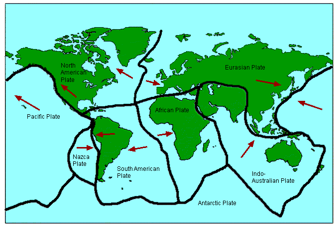 In 1912, Alfred Wegener and Frank Taylor first outlined the concept of continental drift, which proposed that the surface of the Earth is in motion albeit very slowly. At first the idea was considered preposterous by the scientific community but gradually gained acceptance as evidence in its favour accumulated. In the early 1960’s the theory of ‘sea-floor spreading’ was developed and gradually the idea that the Earth’s surface consists of a number of plates that move relative to each other gained acceptance and evolved into the theory of plate tectonics that we have today. However, there are some anomalies that the present theory does not explain so further revision is probably required.
These anomalies together with the geographical match between the two continents led to the formulation of the Expanding Earth Hypothesis(b).
When sea-floor spreading was identified in the Atlantic, some writers investigated where it might fit into the drama of Atlantis. It is not surprising that plate tectonics has been claimed by some, such as Frank Joseph, to support the existence of Atlantis, while others, including sceptic Paul Jordan, maintain that it makes the existence of Atlantis in the Atlantic an impossibility.
A further sceptical view of Atlantis in the Atlantic, by Benjamin Radford, claims(k) that “plate tectonics demonstrate that Atlantis is impossible; as the continents have drifted, the seafloor has spread over time, not contracted. There would simply be no place for Atlantis to sink into. As Ken Feder notes, ‘The geology is clear; there could have been no large land surface that then sank in the area where Plato places Atlantis. Together, modern archaeology and geology provide an unambiguous verdict: There was no Atlantic continent; there was no great civilization called Atlantis.'” This, of course, is perfectly true, except that Plato placed Atlantis in the Atlantic Sea, which many believe was a reference at that particular time to the Western Mediterranean!
An interesting website on the subject of the problems associated with the theory of plate tectonics by David Pratt is worth a read(a)(d)(i).>N.C. Smoot has also written(p) about anomalies encountered with the conventional theory of plate tectonics and possible solutions.<
Equally critical is the opening chapter of Thomas J. Krupa’s book Biblical Flood, Noah’s Ark and the Star of David[1010]. Sustained opposition to the theory has found expression in the NCGT Journal(e)since 1996.
Robert Bauval has written a paper on the possible effect that plate tectonics may have had on the accuracy of the orientation of the Giza pyramids(m).
Marvin Herndon has proposed a new theory, which he has entitled ‘Whole-Earth Decompression Dynamics’; a subtle combination of plate tectonics and the Expanded Earth Hypothesis(g). The idea of subduction is also challenged by the New Pangaea Theory (NPT)(h).
The starting point of NPT is that “252 million years ago our planet was impacted by a massive comet, a comet far larger than the one that wiped out the dinosaurs. This previous impact was so powerful it fractured the Earth’s crust, began the breakup of Pangaea and wiped out most of the life on the planet.”(o) The author, J. Chris Everett, proposes the comet, 100km in diameter, was absorbed into the body of our planet.
P.P. Flambas, author of Plato’s Caribbean Atlantis[1368] in which he has proposed a modification to the current theory of PT, which he has called the ‘Hydraulic Hypothesis’ to explain shortcomings in accepted PT theory and support his Atlantis location.
A July 2016 report was published on the rate of tectonic movement, estimated to be comparable to the speed of fingernail growth(f).
In 2020, it was reported that “scientists are beginning to understand the importance of another characteristic of any planet likely to support life, and it is one that fits squarely into (James) Lovelock’s view of Earth as a dynamic participant rather than a passive backdrop: an active system of drifting continents, otherwise known as plate tectonics. On the face of it, the connection between life, with its relatively brief cycles and dizzying complexity, and plate tectonics, with its much slower cycles and ostensibly simpler interactions, appears tenuous. But on Earth, at least, that connection is direct and deep.” (n).
Evidence of plate tectonics has now been identified on Mars(c)! In October 2019 NASA confirmed that a number of ‘marsquakes’ have been confirmed on the ‘Red Planet’(l). So far, the evidence suggests that our planet is more moon-like than earth-like.
(a) https://davidpratt.info/tecto.htm
(b) https://web.archive.org/web/20171105200137/https://www.grisda.org/origins/15053.htm
(c) https://www.sciencedaily.com/releases/2012/08/120809155831.htm
(d) https://www.thunderbolts.info/wp/2012/11/27/serious-issues-with-plate-tectonics-2/
(e) http://www.ncgtjournal.com/index.html
(g) http://www.nuclearplanet.com/510090.pdf
(h) https://web.archive.org/web/20170429173617/https://newpangaeatheory.com/the-enigmas/
(i) An Alternative to Plate and Expansion Tectonics – Thunderbolts Forum (v2.0) (archive.org) (new link) *
(j) https://www.researchgate.net/publication/238388608_Francis_Bacon_and_Continental_Drift
(k) https://www.livescience.com/23217-lost-city-of-atlantis.html
(l) https://www.universetoday.com/143625/insight-has-already-detected-21-marsquakes/
(m) http://www.robertbauval.co.uk/articles/articles/platetectonicsandgp.html
(n) https://nautil.us/why-aliens-and-volcanoes-go-together-1879/
(o) https://web.archive.org/web/20170429211143/https://newpangaeatheory.com/the-new-pangaea-theory/
(p) https://www.researchgate.net/publication/253098613_Earth_Geodynamic_Hypotheses_Updated *
Ortelius, Abraham
 Abraham Ortelius (1527-1598) was a Flemish cartographer who produced the first modern atlas, Theatrum Orbis Terrarum[1226], which at the time was reputed to have been the most expensive book ever printed.
It is interesting that he included the mythical island of Hi-Brasil (Brasil) off the coast of Ireland as well as the equally mysterious Frisland (Frieslant). Both can be clearly seen on his map using the link below(a).
In 1596 Ortelius was struck by the possibility that America, Europe and Africa had at one time been joined together but had over time become separated, an idea expressed in his Thesaurus Geographicus[1225]. Ortelius also included a speculative southern landmass, Terra Australis, which he designated as a “land of parrots”.
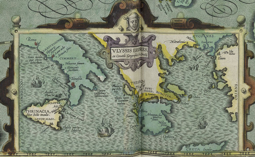
In 1597, Ortelius was the first to map(d) the travels of Homer’s Odysseus, notably locating all his adventures in the Central and Eastern Mediterranean, which was probably just a reflection of the limits of Greek maritime knowledge at the time that the narrative originated!
Ortelius suggested that Atlantis had been located in North America but that they had separated in the very distant past! Before modern theories of Continental Drift and its successor, Plate Tectonics, the idea of landbridges between continents was popular as an explanation for the spread of animals and people around the world. Some suggested as an alternative, the existence of lost continents such as Atlantis in the Atlantic, which acted as a stepping-stone between the continents(c).
Four hundred years later Alfred Wegener incorporated some of Ortelius’ ideas into his theory of Continental Drift, which later led to the current theory of Plate Tectonics.
A purpose-built polar exploration ship, m.v. Ortelius, was named after the geographer.
Recently, Doug Fisher has drawn attention to the similarities between a 1592 map of South America by Ortelius and the well-known Kircher map of Atlantis(b).
(a) https://upload.wikimedia.org/wikipedia/commons/e/e2/OrteliusWorldMap1570.jpg
(b) https://atlantismaps.com/chapter_7.html (link broken Oct. 2018) New website in development. (https://www.copheetheory.com/)
(c) Wayback Machine (archive.org) *
(d) https://www.laphamsquarterly.org/roundtable/geography-odyssey
Wegener, Alfred
Alfred Wegener (1880-1930) was a German professor of meteorology who in 1912 advanced the theory of Continental Drift, which proposed that the continents were in motion, however slowly. In this context, he contended that Atlantis was a distant  memory of the time when America, Europe and Africa were joined. However, the rate of ‘drift’ is so slow that such a conjunction of the continents would have broken up long before the emergence of modern man. Unfortunately, Wegener died while exploring the Greenland ice cap.
As early as 1842 Frederik Klee had suggested that originally there had existed one large megacontinent which later broke up(a), an idea later echoed by Wegener.
>The discovery of the Mid-Atlantic Ridge in the 19th century had allowed geologists and botanists to suggest that it may have provided a stepping-stone or landbridge across the Atlantic explaining the shared biota on both sides of the ocean. Some also thought that the Mid-Atlantic Ridge provided a possible home for Atlantis. However, Wegener’s proposed theory of continental drift did not allow room in the Atlantic for a continent-sized Atlantis leaving some geologists who were Atlantis supporters somewhat unhappy.<
Wegener’s theory was slowly accepted and eventually morphed into the theory of ‘plate tectonics’ in the 1960’s. But, even today, the latest tectonic concepts appear to have been brought into question by a study of the lava fields of Saudi Arabia. The theory is also under attack by supporters of the Expanded Earth hypothesis(b). On the other hand, an Islamic website has identified a reference in the Qur’an to the concept of an expanding Earth(c).
(a) See Archive 5144
(b) https://www.wincom.net/earthexp/n/navback.htm (offline Aug. 2017)
(c) See Archive 3384


