Latest News

Joining The Dots
I have now published my new book, Joining The Dots, which offers a fresh look at the Atlantis mystery. I have addressed the critical questions of when, where and who, using Plato’s own words, tempered with some critical thinking and a modicum of common sense.Read More »
deglaciation
Italy
Italy seems to have an uncertain etymology; Thucydides claims that Italos, the Sicilian king gave his name to Italy, while more recently Emilio Spedicato(h) considers that ”the best derivation we believe to be the one proposed by the Italian nuclear engineer Felice Vinci (1998), in his monograph claiming a Baltic setting for the Homeric epic: he derives Italia from the rare Greek word aithalia, meaning the smoking one.” This is thought to be a reference to Italy’s many volcanoes.
Italy today is comprised of territory south of the Alps on mainland Europe including a very large boot-shaped peninsula, plus Sicily, Sardinia and some smaller island groups, which along with the French island of Corsica virtually enclose the Tyrrhenian Sea.
The earliest proposal that Italy could be linked with Atlantis came from Angelo Mazzoldi in 1840, when he claimed that before Etruria, Italy had been home to Atlantis and dated its demise to 1986 BC. Mazzoldi expressed a form of hyperdiffusion that had his Italian Atlantis as the mother culture which seeded the great civilisations of the eastern Mediterranean region(b).
Some of Mazzoldi’s views regarding ancient Italy were expanded on by later scholars such as Camillo Ravioli, Ciro Nispi-Landi, Evelino Leonardi, Costantine Cattoi, Guido DiNardo and Giuseppe Brex. Ravioli sought to associate the Maltese island of Gozo with his proposed Atlantis in Italy.
The Italian region of Lazio, which includes Rome, has had a number of very ancient structures proposed as Atlantean; Monte Circeo (Leonardi) and Arpino(a) (Cassaro). Another aspect of Italian prehistory is the story of Tirrenide, which was described as a westward extension of the Italian landmass into the Tyrrhenian Sea during the last Ice Age, with a land bridge to a conjoined Sardinia and Corsica. At the same time, there were land links to Sicily and Malta, which were all destroyed as deglaciation took place and sea levels rose.
 It is surprising that so few researchers have commented on Italy’s part in Plato’s Atlantis narrative considering that he twice, without any ambiguity, informs us that the Atlantean domain extended as far as Tyrrhenia (modern Tuscany).
Crit.114c. So all these, themselves and their descendants dwelt for many generations bearing rule over many other islands throughout the sea and holding sway besides, as was previously stated, over the Mediterranean peoples as far as Egypt and Tuscany. Tim.25a/b. Now in this island of Atlantis there existed a confederation of kings, of great and marvellous power, which held sway over all the island, and over many other islands also and parts of the continent; and, moreover, of the lands here within the Straits they ruled over Libya as far as Egypt, and over Europe as far as Tuscany. (Bury)
The quotation from Timaeus is most interesting because of its reference to a ‘continent’. Some have understandably but incorrectly claimed that this is a reference to America or Antarctica, when quite clearly it refers to southern Italy as part of the continent of Europe. Moreover, Herodotus is quite clear (4.42) that the ancient Greeks knew of only three continents, Europe, Asia and Libya.
Philo of Alexandria (20 BC-50 AD) in his On the Eternity of the World(g) wrote “Are you ignorant of the celebrated account which is given of that most sacred Sicilian strait, which in old times joined Sicily to the continent of Italy?” (v.139). The name ‘Italy’ was normally used until the third century BC to describe just the southern part of the peninsula(e). Some commentators think that Philo was quoting Theophrastus, Aristotle’s successor. This would push the custom of referring to Italy as a ‘continent’ back near to the time of Plato. More recently, Armin Wolf, the German historian, when writing about Scheria relates(f) that “Even today, when people from Sicily go to Calabria (southern Italy) they say they are going to the ‘continente’.” This continuing usage is further confirmed by a current travel site(d) and by author, Robert Fox[1168.141]. I suggest that Plato used the term in a similar fashion and can be seen as offering the most rational explanation for the use of the word ‘continent’ in Timaeus 25a.
When you consider that close to Italy are located the large islands of Sicily, Sardinia and Corsica, as well as smaller archipelagos such as the Egadi, Lipari and Maltese groups, the idea of Atlantis in the Central Mediterranean can be seen as highly compatible with Plato’s description.
If we accept Plato stated unambiguously that the domain of Atlantis included at least part of southern Italy and also declared Atlantis attacked from beyond the Pillars of Heracles, then this appellation could not be applied at that time to any location in the vicinity of the Strait of Gibraltar but must have been further east, probably not too far from Atlantean Italy. This matches earlier alternative locations recorded by classical writers who placed the ‘Pillars’ at the straits of Messina or Sicily. I personally favour Messina, unless there is stronger evidence that some of the islands in or near the Strait of Sicily, such as the Maltese or Pelagian Islands, or Pantelleria, were home to the ‘Pillars’.
(a) http://www.richardcassaro.com/hidden-italy-the-forbidden-cyclopean-ruins-of-giants-from-atlantis
(b) http://web.archive.org/web/20211202122517/https://atlantipedia.ie/samples/archive-2509/ (Eng),
http://web.archive.org/web/20211021081119/https://atlantipedia.ie/samples/archive-2943/ (Ital)
(c) http://web.archive.org/web/20200215123300/https://atlantipedia.ie/samples/archive-2946/
(d) Four Ways to Do Sicily – Articles – Departures (archive.org)
(e) https://profilbaru.com/article/Name_of_Italy
(f) Wayback Machine (archive.org)
(g) http://www.earlychristianwritings.com/yonge/book35.html
(h) http://2010-q-conference.com/ophir/ophir-27-10-09.pdf
Lake Agassiz
Lake Agassiz was a very large glacial lake in North America, that discharged into the Atlantic Ocean just as, further west, Lake Missoula, emptied into the Pacific.
Studies in 2003 by a team led by Garry Clarke, a geophysicist at the University of British Columbia, reported that “Lake Agassiz, reached a massive 163,000 cubic kilometres in volume—at least double that of the largest contemporary lake, the Caspian Sea—and concluded that its release was ‘by far the largest known glacial outburst of the past 100,000 years.’ The report dates the event at about 8,500 years ago.” (b)(c)

A few years later, studies of the effects of these Agassiz discharges found a correlation between the Canadian flood and the sudden development of European farming(a). Chris Turney of the University of Exeter has linked this event with the migration of up to 145,000 people from the Black Sea farming sites to inland Europe.
See Deglaciation and Ronnie Gallagher
(a) Noah’s Ark flood spurred European farming | Reuters (archive.org)
(b) News in Science – Ancient superflood brought climate chaos – 15/08/2003 (abc.net.au)
(c) Atlantis Rising magazine #42 p.10 http://www.pdfarchive.info/index.php?pages/At (link broken)
Sea-Level Changes
Sea-Level Changes. Recent years have seen the production of ever more detailed data relating to sea-level changes following the last Ice Age. In 2006, researchers discovered that the Bering Strait between Siberia and Alaska was created around 9000 BC, a thousand years earlier than previously thought.
Such changes could have had a direct bearing on the Atlantis mystery, particularly if Plato’s assertion that its inundation took place in 9600 BC is true, as this would place the event at the end of the last Ice Age and the melting of the glaciers, with the consequent raising of the level of the oceans. Although we are usually given the impression that this deglaciation progressed steadily, it would appear that in reality the process continued at different rates and was at times temporarily reversed.
Recent studies(f) have clearly indicated that Aboriginal Australians have preserved memories of the rising sea level at the end of the last Ice Age.
A 2000 report(c) from Dr Robert Baker and Professor Peter G.Flood from the University of New England in New South Wales, suggests that 4,000 years ago sea levels “may have been up to two metres higher than at present and that sea levels have risen and fallen like a roller coaster over the last 6,000 years.” I would expect that sea levels two metres higher around 2000 BC would have left archaeological evidence on a global scale. Until that is forthcoming, I would treat this claim with caution.
Dr Robert Haworth, who worked with Dr Baker, endorsed the conclusions of Baker and Flood(k). A few years later Haworth found further evidence of higher temperatures and sea levels in the Sydney area 6,000 years ago(l).
 Estimates of the total change in sea levels vary between 300 and 500 ft. The most recent studies have estimated the rate of sea-level rise at an average of one metre per century, punctuated by occasionally increased rates of 2.5 metres per century(a). To complicate the picture further, many areas in northern latitudes that had been depressed by the weight of the enormous ice sheets of the last Ice Age, rose considerably as a result of isostatic rebound when the glaciers melted. This process continues in some regions, albeit at a slower rate.
There is general agreement that the raising of the sea-levels had dramatic consequences worldwide. Vast landmasses, such as Sundaland, the Celtic Shelf, and the Caribbean, were totally or partially submerged, leaving many of today’s islands as remnants. Communities that had flourished in these regions during the last Ice Age must have been devastated which naturally led to the generation of myths recalling their former glory. Atlantis is assumed to be one such legend with a firm basis in reality.
Other, more controversial effects have also been proposed, such as the breaching of a landbridge that had existed between Spain and North Africa at Gibraltar and/or a similar isthmus between Sicily and Tunisia. James Bramwell reports that in the 1930s geologists spoke freely of the breaching of a Gibraltar dam around 15,000 years ago. More recently, writers such as Joseph S. Ellul, Sergio Frau and Paulino Zamarro have convincingly based their Atlantis theories on this concept. The Mediterranean sea level is discussed elsewhere.
Other writers have proposed an asteroidal or cometary impact as the cause of catastrophic flooding, but such inundations would have receded fairly rapidly. In the end, we are left with the ending of the last Ice Age as the primary cause of profound changes in the topography of our planet which probably included the submergence of one civilisation that we now refer to as Atlantis.
However, Plato introduces another detail into his Atlantis narrative, namely that following the submergence of Atlantis, it created a maritime hazard in the form of shoals. Plato wrote that “wherefore also the ocean at that spot has now become impassable and unsearchable, being blocked up by the shoal of mud which the island created as it settled down.” (Timaeus 25d). The implication of this is that the shoals still existed in either Solon’s or Plato’s lifetime. We must also keep in mind that the draft of ships, such as triremes, at that time was about a metre. The attached chart shows how, between 5000 BC and the present, the rate of sea level has been relatively slow. Even allowing for any local seismic, tectonic or isostatic activity, I would interpret the data to suggest two important facts; first, the flooding of Atlantis could not have taken place before 5000 BC and still be a hazard in the first millennium BC and secondly, if it occurred after 5000 BC, Atlantis must be still in shallow water.
Kurt Lambeck has demonstrated from a study of Roman fish pens that the sea level along the Italian coast, 2000 years ago, was 1.35 metres below today’s levels. His investigations also included a study of land elevations along the coast that may have been affected by seismic or tectonic processes and found that they had raised the land by 1.22 metres, indicating that global sea levels had risen by just 13cm over the past two millennia, most of which has occurred over the past century(d)! Lambeck’s conclusions have been severely criticised by Izabol Apulia(e).
Professor Nicholas Flemming of the University of Southampton has written extensively on the subject of sea-level changes [1682], particularly in the Mediterranean(h). A more localised study of sea-level changes around Malta during the Holocene has been produced by an Italian team led by Stefan Furlani(i).
Furthermore, if the destruction took place before 5000 BC, then either Solon or Plato concocted the description of the shoals, which would have no purpose whatsoever!
Sea level changes in the Gulf of Mexico are discussed in an online pdf file(b). In the same region, there is now claimed to be evidence(g) confirming that sea levels were lower during the last Ice Age and that the Yucatan Peninsula was very much larger.
A June 2021 report(j) concluded that Israeli sea levels rose at a relatively fast rate of 2 – 2.5 metres within 200 years between the Hellenistic and Roman periods. I am not aware of any corroboration from other sites in the region, so, lacking any such evidence, I am forced to conclude that this is more likely to have been the consequence of localised seismic activity rather than a more general rise in sea levels. On the other hand, seismic events are usually instant and not spread over centuries! Further investigation is required.
(a) https://www.sciencedaily.com/releases/2010/12/101201120605.htm
(c) https://web.archive.org/web/20110912071448/https://www.abc.net.au/quantum/stories/s112352.htm
(d) https://www.freerepublic.com/focus/news/1192397/posts
(e) http://web.archive.org/web/20191216092056/https://atlantipedia.ie/samples/archive-2566/
(f) https://theconversation.com/ancient-aboriginal-stories-preserve-history-of-a-rise-in-sea-level-36010
(g) https://phys.org/news/2016-11-dino-killing-crater-clues-ice-age.html
(h) https://www.gresham.ac.uk/watch-now/humanity-and-million-years-sea-level-change *
(i) https://www.researchgate.net/publication/235606249_Holocene_sea_level_change_in_Malta
(k) Atlantis Rising magazine # 22 p11
(l) https://www.abc.net.au/science/articles/2004/04/01/1078868.htm?site=tv&topic=latest
Britain .
Britain. For as long as I can remember, received wisdom told us that the ancestors of the British (and Irish) had ‘Celtic’ origins. Then in 2007, Dr Stephen Oppenheimer, professor of genetics at Oxford University ‘threw a cat among the pigeons’ when he bluntly wrote “Everything you know about British and Irish ancestry is wrong. Our ancestors were Basques, not Celts” in Origins of the British [1950]. The late R.Cedric Leonard reviewed Oppenheimer’s claims in his book and two earlier papers(d)(e)(f).
Britain as the home of Atlantis has been claimed by many writers and not without undertones of nationalism by some of the British authors. Nevertheless, support for the idea has been offered by a number of more disinterested researchers. Probably the first to advance this idea was John Wallis (1660-1703), who, in 1700, proposed that the Atlantis story had been corrupted over time and was a reference to the destruction of the landbridge that had existed between France and England, leaving a British Atlantis more isolated (The original Brexit!)(c). It was nearly a century before the idea was taken up by Thomas Pennant and then more than another century passed before Cooper, Spence, Beaumont and Calestani produced related theories. Fast forward to the 21st century, when Donald Ingram identifies the Wessex II culture as Atlantean and Melville Nicholls considers Britain to be one of the Atlantean islands referred to by Plato.
The precise location, the exact date and the probable cause of the destruction of Atlantis are the basis for a range of theories. There is general acceptance, that following the deglaciation at the end of the last Ice Age, vast regions of low-lying land that had linked Ireland and Britain to mainland Europe were gradually flooded.
One school of thought is that these flooded regions contained Atlantis, of which the most extensive was in the North Sea and is now known as Doggerland. Other offshore locations proposed for Atlantis are the Celtic Shelf (Gidon, Steuerwald & Koudroiavtsev) and the Irish Sea (Dunbavin). These lands had been settled and following the inundations, its inhabitants were forced to retreat to the higher ground, of what is modern Europe and the British Isles.
David L. Hildebrandt in Atlantis-The Reawakening [1602] proposes a reworking of the ‘Atlantis in Britain’ theory with some new perspectives. For me, his date, location and identity of the Atlanteans do not ring true, particularly why Stone Age people in Southern Britain would want to launch an attack on Athens, over 2,000 miles away, a city-state that did not even exist at the time. Those early Britons did not have the wheel, yet Plato tells us that the Atlanteans had chariots!
Another view is that Atlantis was destroyed by the impact of a comet or asteroid, an idea espoused by Dunbavin and Spence.
E. J. de Meester on his now-defunct website postulated a link between Stonehenge and Atlantis(b). After arbitrarily dividing Plato’s dimensions by ten, he suggested that the plain described by Plato lay in a rectangle between Salisbury and Chichester.
A recent suggestion by a Dutch commentator, Leon Elshout, places the biblical Tarshish in Britain(h), an idea also supported by a Christadelphian website(g).
(a) https://sabidius.blogspot.com/2010/06/atlantis-was-it-britain.html
(b) https://web.archive.org/web/20090614050055/https://home-3.tiscali.nl/~meester7/engatlantis.html
(c) https://royalsocietypublishing.org/doi/10.1098/rstl.1700.010
(d) http://www.prospectmagazine.co.uk/magazine/mythsofbritishancestry/
(e) http://www.prospectmagazine.co.uk/magazine/mythsofbritishancestryrevisited/
(f) https://web.archive.org/web/20170113172907/http://www.atlantisquest.com/Bretons.html
(g) Incredible Archaeological Find Proves Tarshish Is Britain! (archive.org)
Isostatic Rebound
Isostatic Rebound (Post-Glacial Rebound) is the term used to describe the ‘springing back’ of the Earth’s crust following deglaciation. Even today, many thousands of years after the last Ice Age, we can detect this ‘rebound’ continuing. In parts of North America, this has been measured at up to half an inch per year, although this must be seen as somewhat exceptional. After the last Ice Age, parts of what is now southern and western Finland were under water but as the crust began to rise land rose above sea level and is still doing so today. Since the rate of rebound is known, archaeologists have been able to use the process to date prehistoric sites in the region. There are a number of useful websites that explain the process(a)(b).
Glacier Bay (Alaska) and the surrounding area show the fastest rates of isostatic uplift on the planet. An uplift of about 5.5 meters has taken place in Glacier Bay since the retreat of glacial ice, beginning about 250 years ago. Uplift should continue for several hundred more years(c).
A comparable situation is also found in the Hudson Bay region which had some of the heaviest glacial ice during the last Ice Age and was the final area to have the ice melt away. The land surface there is rising more than a half-inch per year — more than 4 feet per century(d).
Another example of this rebound was recently (June 2024) mentioned in a BBC article in relation to the Finnish island of Maakalla. It revealed that ” when the island was discovered [by fishermen and seal hunters in the 15th Century], it was only 9mm above the water’s surface,” explained Matti Hautala, the boat captain who ferried us here from Keskuskari harbour on the mainland. Everything around me was once submerged under water, but each year since the weight of Ice Age glaciers that once covered this area melted more than 10,000 years ago, the land holding Bothnian Bay continues to slowly rise – a phenomenon known as glacio-isostatic uplift. Today, the island is more than 5m above sea level(e).
(a) https://web.archive.org/web/20191102194637/https://academic.emporia.edu/aberjame/ice/lec09/lec9.htm
(b) https://www.antarcticglaciers.org/glaciers-and-climate/sea-level-rise-2/recovering-from-an-ice-age/
(c) https://scitechc.com/faq/what-is-isostatic-rebound-in-glacier-geology/ (link broken) *
(d) https://eu.freep.com/story/news/local/michigan/2018/03/02/michigan-great-lakes-ice-age/363316002/
(e) https://www.bbc.com/travel/article/20240624-maakalla-europes-isolated-autonomous-island
Deglaciation
The Deglaciation that occurred at the end of the last Ice Age has attracted a lot of attention from Atlantis seekers because it coincides with Plato’s apparent date for the destruction of Atlantis and provides us with a possible source of the flood, that subsequently not only wiped out the Atlanteans but possibly also the Athenians. However, meltwater from deglaciation causes global sea levels to rise very, very, slowly and so is extremely unlikely to have caused the destruction of the Atlanteans or Athenians as described by Plato.
The melting of the ice caps gradually caused the ocean levels to rise over thousands of years and at times the retreat of the glaciers was halted and occasionally reversed. Although the melting of the ice was relatively steady, the water produced did not always reach the sea in a steady flow. Instead, it was frequently punctuated by enormous discharges of water, particularly where ice dams had retained vast meltwater lakes.
In the 1920s, a maverick geologist, J Harlen Bretz (1882-1981), postulated that a huge ice-age flood had  carved the landscape of Eastern Washington state, in just a few days. In spite of acrimonious opposition from the geology establishment of the day, Bretz persevered with his investigations, which eventually led to the identification of Lake Missoula as the probable culprit. Bretz was finally vindicated in 1979 when, in his nineties, he was awarded the prestigious Penrose Medal for his work(f). There is a beautifully illustrated National Geographic online article that reviews Bretz’s work(i).
These discharges of huge quantities of water are recognisable as relatively sudden spikes in the rate of sea level increases and are referred to as Melt Water Pulses WMP).
Lake Missoula in what is today the state of Montana, is one of the best-studied of these glacial lakes. The regular discharges from Lake Missoula, following ice dam collapses, were responsible for the creation of the dramatic Scablands of the North-Western United States. Studies have revealed that between forty and eighty such floods were released from Lake Missoula alone.
However, an alternative to Lake Missoula as the cause of the scablands has been recently proposed(g), namely, the younger-dryas comet impact event. This event was highlighted by Richard Firestone and his colleagues in The Cycle of Cosmic Catastrophes[0110]. My problem with the idea of the comet impact is that it was a single event, whereas the Missoula discharges were according to some authorities quite numerous!
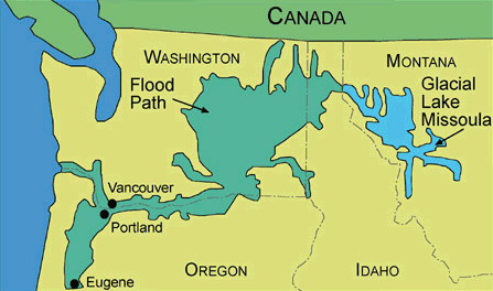
Lake Missoula and its flood path
The power of fast-flowing water was recently highlighted by a report published(c) in the journal of America’s National Academy of Sciences, where a study of Iceland’s unpronounceable Jokulsargljufur canyon indicated that this huge feature was created in a matter of days. In Iceland, such glacial outburst floods are known as Jökulhlaups(d).
It has now been estimated by scientists that around 6200 BC, the ancient glacial Lakes Agassiz and Ojibway discharged into the Atlantic Ocean. These lakes were more than twice the size of the Caspian Sea and on their own are estimated to have raised sea levels by up to 4 feet. The freshwater flow is calculated at between 25 and 50 times the flow of the Amazon River and recent studies suggest that this sudden inflow of fresh water brought the Gulf Stream to a halt for more than a hundred years. A 2016 report(e) from CAGE (Center for Arctic Gas Hydrate, Climate and Environment) suggests that the Gulf Stream was not interrupted during the Ice Age.
Graham Hancock, in his Magicians of the Gods [1119], reviews, at length, the theories of J Harlen Bretz and after a shared field trip and lengthy discussions with Randall Carlson, concluded that Bretz had probably only revealed part of the Scablands story. Hancock has pointed out that Bretz was unaware of the cometary impact identified by Richard Firestone et al., which coincided with the start of the Younger Dryas period 12,800 years ago. This impact theory continues to amass confirmatory data, but the opposition has not abated yet. The cometary impact, the creation of the Scablands and the start of the Younger Dryas cooling period, all seem to coincide temporally to a degree that strongly suggests an interconnection.
Nick Thom has suggested[776] that an even more dramatic consequence of the discharge from Lake Agassiz was the tilting of the Earth’s axis, leading to the biblical Deluge and recorded around the world in hundreds of flood myths!
Similar meltwater lakes across Northern Europe retained by ice dams produced equally dramatic discharges as the dams periodically broke. One of these occupied what is now the Baltic Sea and was 30 metres above the then ocean level, before bursting into the North Sea around 10,000 BC. Less well known is the flooding that took place further east, resulting in the creation of a vast inland sea, of which the Black and Caspian Seas were just a small part. Ronnie Gallagher has written a revealing paper on the subject(a).
It is worth noting that, although on a smaller scale, two-thirds of the thousands of Himalayan glaciers contain glacial lakes, which because of global warming today are growing at risk of bursting with consequent catastrophic results. As these glaciers retreat, apart from the damage to people and property, the discharges will gradually reduce the downstream flow of water to rivers such as the Ganges.
Concurrent, with these huge meltwater lake discharges, were the Heinrich Events, named after 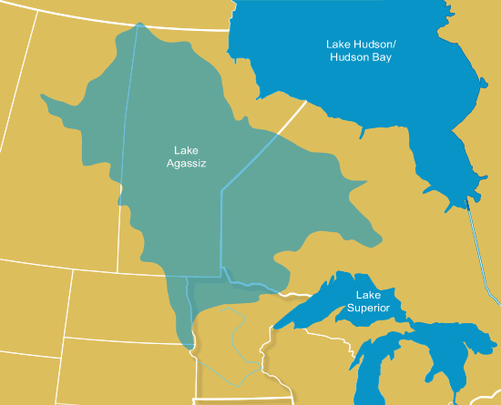
paleoclimatologist, Hartmut Heinrich, as recently as 1988, published evidence that there had been at least six massive discharges of icebergs from the Laurentide Ice Sheet during the last Ice Age. These discharges could have contained millions of cubic kilometres of ice and must have caused substantial sea level rises. This Laurentide Ice Sheet was an enormous mass of ice that stretched from the Arctic through eastern Canada, to the northern half of the United States, that covered over 5 million square miles. The weight of this ice sheet was so great that it has been calculated, that it depressed the earth’s crust by nearly half a mile. A recent paper contends that it was the collapse of this ice sheet, 8000 years ago causing a sea level rise that led to the breaching of a ridge damming the Bosporus and the inundation of the then freshwater Black Sea, which flooded over 73,000 square km of land.
In the southern hemisphere, it was discovered a few years ago (Science, Dec.22, 2000) that the River Amazon had experienced a doubling of its outflow between 9800 BC and 9700 BC, probably as a consequence of the melting of Andean glaciers and perhaps increased rainfall during this period. The dates proposed are very close to the 9600 BC date provided by Plato for the submergence of Atlantis.
All these worldwide discharges must have resulted in the inundation of low-lying landmasses, such as the Celtic Shelf or Sundaland, in fits and starts forcing the inhabitants of these regions to regularly migrate to higher ground.
Since it is reasonable to assume that a large percentage of human settlements were then, as now, located along coasts, particularly at river mouths, the consequence for these embryonic cultures must have been catastrophic. It is very easy to see how legends of sunken civilisations probably have a very sound basis in fact. Two books by Graham Hancock[274] and Stephen Oppenheimer[004] have covered this idea in greater detail, lending credibility to the idea of a sunken island such as Atlantis.
However, it can be reasonably argued that the effects of deglaciation are not what Plato described. He spoke of earthquakes and a flood that overwhelmed both the Athenians and the Atlanteans. This would more closely match the aftermath of a large seismic or tectonic event that generated enormous tsunamis, rather than the gradual rising of sea levels, which even at its most dramatic, could never have produced the effect of sinking Atlantis overnight.
However, the waters of tsunamis eventually flow back to the sea, Plato’s account describes the event resulting in the creation of muddy shallows. To me, it sounds more like liquefaction, which occurs in soil with particular characteristics when subjected to an earthquake(b), similar to the destruction of the cities of Canopus and Herakleion near Alexandria.(j)
A website that comprehensively explains, in a slideshow format, all aspects of deglaciation from Lake Missoula to Milankovitch Theory is worth a look(h).
Furthermore, although the threat is nothing like the scale posed by glacial lakes at the end of the last Ice Age, it has been estimated that even today around 15 million people are at risk from flooding by outbursts from dammed lakes and half of them are in just four countries, India, Pakistan, Peru and China(k).
(a) Wayback Machine (archive.org)
(c) (BBC Feb 10, 2015) https://www.bbc.com/news/science-environment-31356229
(d) Jökulsárgljúfur Canyon | Visit North Iceland
http://web.archive.org/web/20120120035107/https://geology.about.com/od/flooding/a/aa_041397jokul.htm
(e) https://www.sciencedaily.com/releases/2016/02/160219134816.htm
(f) https://www.detectingdesign.com/harlenbretz.html
(g) https://atavisionary.com/tag/atlantis/
(h) https://slideplayer.com/slide/2808821/
(i) How Did the Channeled Scablands Form? (archive.org)
(k) (BBC Feb 07, 2023) Millions face threat of flooding from glacial lakes – BBC News
Deruelle, Jean *
Jean Deruelle (1915-2001) was a French mining engineer, who identified Northern Europe as the cradle of technological development, preceding the great civilisations of the Middle East. He contends that the advances of Northern Europe diffused to the southern nations of the Mediterranean. Deruelle identified Imhotep as an Atlantean immigrant to Egypt, where he contributed to the advances of its civilisation during the 3rd millennium BC and became its chief architect.
More specifically, he places Atlantis in the North Sea, on the Dogger Bank, which is a shoal around 100 km off the northeast coast of England. He has written at least two books[278][279] on the subject of Atlantis.
Deruelle identified the megalith builders of western Europe as Atlanteans, an idea adopted by Sylvain Tristan, who also wrote a highly favourable review of Deruelle’s theories(c).
A number of maps illustrating his theory are available on a French forum(a).
Fortunately, an English translation of his theory is available on the de Grazia website(b).
Deruelle imaginatively proposed that the great plain of Atlantis lay to the east of the Dogger Bank, stretching as far as what is now Denmark. Plato described the plain as being surrounded by a huge ditch. Then Deruelle, with a flash of ingenuity claimed that it was not a ditch but instead was a dyke, designed to hold back the slowing advancing waters of the North Sea that were being fed by deglaciation. He endeavoured to reinforce this claim with the proposal that the Greek word for ditch, ‘taphros’ can also be used for dyke. This interpretation seems possible according to W.K. Pritchett, the distinguished historian [1622.52.5].
(a) Histoire Secrète :: L’ atlantide megalithique – Jean Deruelle (archive.org) *
(b) The “Great Plain” of Atlantis – was it in Doggerland? (archive.org)
(c) Jean Deruelle’s Atlantis – Atlantisforschung.de (atlantisforschung-de.translate.goog)