Latest News

Joining The Dots
I have now published my new book, Joining The Dots, which offers a fresh look at the Atlantis mystery. I have addressed the critical questions of when, where and who, using Plato’s own words, tempered with some critical thinking and a modicum of common sense.Read More »
Corsica
Usai, Luigi
Luigi Usai is the author of La Mappa di Atlantide (The Map of Atlantis) [1814], which, by his own admission, is the result of twenty days of intense study of the subject in early 2021!
Some of his principal claims are that Plato’s mention of the Atlantic Sea was a reference to the Western Basin of the Mediterranean, in the middle of which lay the island of Atlantis that today are the islands of Corsica and Sardinia, but was then conjoined. He specifies the Sardinian region of Sulcis as the home of the Atlantean capital!
His website(a) offers a list of 27 points in support of his thesis. The site itself seems to lack focus wandering into unrelated areas such as suggesting a link between his Corsican/Sardinian Atlantis and the pre-Etruscan Villanovan culture of central Italy. He then proposes that ‘Moors heads’ on the flags of Corsica and Sardinia may have a Sumerian origin!
While I also favour a Central Mediterranean location for Atlantis, I must totally reject his date of 10,000 years ago for its existence as there was no civilisation in Athens or Egypt to attack at that time.
His paper ATLANTIDE ESISTE ED ERA IL GIARDINO DELL’EDEN (ATLANTIS EXISTS AND WAS THE GARDEN of EDEN) added the further claim that his Sardinian Atlantis was also home to the Garden of Eden.
At the very end of 2021, Usai claimed that he had discovered “a hidden unknown mysterious submerged civilization in Sicily-Malta Escarpment”(b). Unfortunately, he has not. In July 2021 I was sent several images, including the large image used by Usai, that purported to show anomalous underwater images in the Central Mediterranean, northeast of Malta. At first sight, they appeared to show extensive manmade features. However, further investigation by my correspondent eventually revealed that the images were the consequence of a flawed computer interpretation of sonar data.
In 2022, Usai published a number of images purporting to show underwater anomalies off the coast of Cuba(c). As Usai has already designated the central region of the Mediterranean as the location of Atlantis I cannot understand his reason for showing such images. Similar anomalies have been found in various parts of the world and explained by Google as data-gathering glitches (see Satellite Imagery). If any of the rectangular features were city walls or streets they would have been kilometres wide – a nonsensical suggestion.
In 2024, André Chaisson, a French civil engineering designer, has now revived interest in the Malta-Sicily Escarpment as the location of an ancient city. He reached this conclusion based on flawed underwater imagery, as did Usai. Chaisson avoids identifying it as Atlantis, as it is too big! Instead, believes that this city “to be Telepylos, the legendary city of the Laestrygonians from Homer’s Odyssey—a land of flesh-eating giants”!(d) Carl Feagans promptly offered a critique of Chaisson’s claims, while also noting Usai’s 2022 related theories(e).
A December 2025 email from Usai making the additional claims that “Tritonis Lake has been found in Sardinia, it’s the sum of the ponds and lakes of Assemini, Elmas, Cagliari, Quartu S. Elena and Capoterra. The Atlas Mountains are the Sulcis Mountains. The Garden of Hesperides is the plain of Capoterra, Frutti D’Oro, near Cagliari.” Some further information is available on a multilingual website(f).
(a) Why didn’t scientists find Atlantis before Usai Luigi? ? Atlantis found!
(c) Cuba high resolution bathymetry – Atlantis exists! Found by Dr. Luigi Usai (atlantisfound.it)
(d) https://grahamhancock.com/chaissona1/
(e) https://ahotcupofjoe.net/2024/12/sicilian-atlantis-or-telepylos/
(f) https://zenodo.org/records/17918171 (the English text is after the Italian text)
Central Mediterranean
The Central Mediterranean is a very geologically unstable region, containing as it does all of Europe’s land-based active volcanoes(a), regular seismic(b) activity with the attendant risk of tsunamis. It is now estimated that a devastating tsunami will hit the Mediterranean every 100 years(c). While the Aegean region experiences the greatest number of earthquakes, the Central Mediterranean, particularly around Sicily, is also prone to regular tremors.
The idea that Atlantis was situated in this region is advocated by a number of researchers, including Alberto Arecchi, Férréol Butavand, Anton Mifsud, Axel Hausmann, as well as this compiler. Plato unambiguously referred to only two places as Atlantean territory (Crit.114c & Tim 25b) North Africa and Southern Italy as far as Tyrrhenia (Tuscany) plus a number of unspecified islands.
The area between Southern Italy and Tunisia has had a great number of sites proposed for the Pillars of Herakles, while possible locations for Gades are on offer, with a number places still known today by cognates of that name.
Plato clearly includes continental territory as part of the Atlantean domain as well as a number of important islands. Within a relatively small geographical area, you have two continents, Africa and Europe, represented by Tunisia and Italy respectively, as well as the islands of Sicily, Sardinia, Corsica and Malta, together with a number of smaller archipelagos, matching Plato’s description exactly. The later Carthaginian Empire also occupied much of the same territory apart from eastern Sicily and southern Italy which by then was controlled by the Greeks and known as Magna Graecia.
For me, the clincher is that within that region, we have the only place in the entire Mediterranean to have been home to elephants up to Roman times – Northwest Africa.
(a) https://en.wikipedia.org/wiki/Volcanology_of_Italy
(b) The Europeam Mediterranean Seismic Centre – EMSC, records all activity in the region.
(c) Tsunami Alarm System – A3M Tsunami Alarm System (tsunami-alarm-system.com) (German & English)
Chiereghin, Luciano
Luciano Chiereghin is an Italian researcher who has a great interest in the history of the Po Valley, both  ancient and modern. In his 2007 book Atlantide al Microscopio (Atlantis Under the Microscope)[1572] he has the plain of the Valley as the location of Atlantis (=Hyperborea) and specifically the ancient town of Adria. He also proposes that Majorca, Sardinia, Corsica, Sicily, Crete and the Peloponnese constituted the island territories of Atlantis.
However, he is not the only one to link this region with Atlantis, as Morven Robertson published a book[1164] in 2015 with a similar theme. Both authors were drawn to the Po Valley by its size and its proximity to the magnificent mountains of the Alps, which protect the plain from the northern winds.
Diego Marin has favourably reviewed Chiereghin’s book(a).
(a) Atlantide al microscopio – Il sito ufficiale di diego marin (archive.org)*
Horned Helmets
Horned Helmets have been worn by various warrior groups from ancient times but, despite popular belief, not by the Vikings. Jürgen Spanuth, the leading proponent of a North Sea Atlantis, has identified the Sea Peoples who attacked the Egyptians as North Sea Peoples. The attack was recorded by the Egyptians on the walls of Medinet Habu and where they depicted some of the invaders with horned helmets. Spanuth claimed that “The only known Bronze Age horned helmets come from north Europe”[0015.55]. The illustrations from the Viscø helmets in the Danish National Museum used by Spanuth[0015.31] were more likely to have been for ceremonial use and show no signs of having been used in battle.
An early 2022 report confirmed that recent radiocarbon dating pushed these helmets back to long before the Vikings – “For many years in popular culture, people associated the Viksø helmets with the Vikings,” said Helle Vandkilde, an archaeologist at Aarhus University in Denmark. “But actually, it’s nonsense. The horned theme is from the Bronze Age and is traceable back to the ancient Near East.”(g)
A January 2018 article highlights a horned figure on the so-called Oseberg Tapestry, who appears to be leading a religious procession, contributing to the theory that the few horned helmets found so far were probably used for ceremonial purposes(e). Another textile fragment found at the same site also depicts a horned person, which to my mind is more reminiscent of a nordic shaman than a warrior.
Baruch Halpern in a footnote in his paper(f) on the Sea Peoples informed us that “Sherden-like horned helmets have also been found along the northern shore of the Black Sea and on statuettes in Sardinia, but that these lack the central disks, and may reflect coincidence, appropriation, trade or migration rather than indicate a place of origin. The iconographic connections of the horns and disk would suggest devotion to a lunar god; see Bernett and Keel (1998).”
 It is noteworthy that the ‘Gjermundbu Helmet’, discovered in 1943 in Nazi-occupied Norway, is the only helmet documented to have existed during the Viking period and is hornless(d).
Furthermore, he was incorrect in claiming that horned helmets were only used in northern Europe during the Bronze Age. Archaeologist Roger Grosjean (1920-1975) has demonstrated(a) that the Torreans of Corsica did use such helmets during that period. The Sherden/Shardana, considered to be one of the Sea Peoples depicted at Medinet Habu are shown as wearing horned helmets and in every instance, except three, they include a round additional piece on the crest. The Shardana are generally accepted to be from Sardinia and are possibly related to the Torreans on neighbouring Corsica. However, the Sardinian examples do not appear to have the accoutrement at the helmets’ crest depicted at Medinet Habu.
Andrea Salimbeti’s website(b) devoted to the Greek Bronze Age has a section on the helmets used in the Aegean during that period, which depicts some horned helmets used by the Mycenaeans(c).
In conclusion, I think Spanuth’s horned helmet evidence is flawed but also that the Sardinian theory is not watertight. Furthermore, his core claim of an invasion from the North Sea into the Eastern Mediterranean is equally untenable. Bronze Age territorial expansion was always into adjacent or nearby territory. A journey of over 4,000 miles from Heligoland to attack Egypt makes no sense.
(b) http://www.salimbeti.com/micenei/index.htm
(c) http://web.archive.org/web/20240120200933/http://www.salimbeti.com/micenei/helmets1.htm (Also see helmets2 & helmets3)
(d) Why Is This the Only Existing Viking Age Helmet? (archive.org)
(e) Mary Ann Bernal: The Confusing Horned Helmets Depicted in the Oseberg Viking Age Tapestries
(f) SCRIPTA MEDITERRANEA, Vol. XXVII-XXVIII, 2006-2007, 15-32
Cadet, Jean-Marcel
Jean-Marcel Cadet (1751-1835) was French mineralogist, who was Inspector of Mines on Corsica for 25 years. He wrote a number of papers and books on the geology of the island. Included in his output was Memoire sur les jaspes et autres pierres precieuses de l’isle de Corse(a), published in 1785, in which he also reviewed Plato’s account of Atlantis in his Critias and Timaeus and concluded that Atlantis had been situated in the Atlantic.
James Bramwell[0184.137] claims that Cadet was the first to express the view that Atlantis had been an island in the Atlantic and that the Canaries and the Azores were its remnants.
My previous entry under the name of Louis Claude Cadet de Gassicourt was completely incorrect, for which I apologise.
Italy
Italy seems to have an uncertain etymology; Thucydides claims that Italos, the Sicilian king gave his name to Italy, while more recently Emilio Spedicato(h) considers that ”the best derivation we believe to be the one proposed by the Italian nuclear engineer Felice Vinci (1998), in his monograph claiming a Baltic setting for the Homeric epic: he derives Italia from the rare Greek word aithalia, meaning the smoking one.” This is thought to be a reference to Italy’s many volcanoes.
Italy today is comprised of territory south of the Alps on mainland Europe including a very large boot-shaped peninsula, plus Sicily, Sardinia and some smaller island groups, which along with the French island of Corsica virtually enclose the Tyrrhenian Sea.
The earliest proposal that Italy could be linked with Atlantis came from Angelo Mazzoldi in 1840, when he claimed that before Etruria, Italy had been home to Atlantis and dated its demise to 1986 BC. Mazzoldi expressed a form of hyperdiffusion that had his Italian Atlantis as the mother culture which seeded the great civilisations of the eastern Mediterranean region(b).
Some of Mazzoldi’s views regarding ancient Italy were expanded on by later scholars such as Camillo Ravioli, Ciro Nispi-Landi, Evelino Leonardi, Costantine Cattoi, Guido DiNardo and Giuseppe Brex. Ravioli sought to associate the Maltese island of Gozo with his proposed Atlantis in Italy.
The Italian region of Lazio, which includes Rome, has had a number of very ancient structures proposed as Atlantean; Monte Circeo (Leonardi) and Arpino(a) (Cassaro). Another aspect of Italian prehistory is the story of Tirrenide, which was described as a westward extension of the Italian landmass into the Tyrrhenian Sea during the last Ice Age, with a land bridge to a conjoined Sardinia and Corsica. At the same time, there were land links to Sicily and Malta, which were all destroyed as deglaciation took place and sea levels rose.
 It is surprising that so few researchers have commented on Italy’s part in Plato’s Atlantis narrative considering that he twice, without any ambiguity, informs us that the Atlantean domain extended as far as Tyrrhenia (modern Tuscany).
Crit.114c. So all these, themselves and their descendants dwelt for many generations bearing rule over many other islands throughout the sea and holding sway besides, as was previously stated, over the Mediterranean peoples as far as Egypt and Tuscany. Tim.25a/b. Now in this island of Atlantis there existed a confederation of kings, of great and marvellous power, which held sway over all the island, and over many other islands also and parts of the continent; and, moreover, of the lands here within the Straits they ruled over Libya as far as Egypt, and over Europe as far as Tuscany. (Bury)
The quotation from Timaeus is most interesting because of its reference to a ‘continent’. Some have understandably but incorrectly claimed that this is a reference to America or Antarctica, when quite clearly it refers to southern Italy as part of the continent of Europe. Moreover, Herodotus is quite clear (4.42) that the ancient Greeks knew of only three continents, Europe, Asia and Libya.
Philo of Alexandria (20 BC-50 AD) in his On the Eternity of the World(g) wrote “Are you ignorant of the celebrated account which is given of that most sacred Sicilian strait, which in old times joined Sicily to the continent of Italy?” (v.139). The name ‘Italy’ was normally used until the third century BC to describe just the southern part of the peninsula(e). Some commentators think that Philo was quoting Theophrastus, Aristotle’s successor. This would push the custom of referring to Italy as a ‘continent’ back near to the time of Plato. More recently, Armin Wolf, the German historian, when writing about Scheria relates(f) that “Even today, when people from Sicily go to Calabria (southern Italy) they say they are going to the ‘continente’.” This continuing usage is further confirmed by a current travel site(d) and by author, Robert Fox[1168.141]. I suggest that Plato used the term in a similar fashion and can be seen as offering the most rational explanation for the use of the word ‘continent’ in Timaeus 25a.
When you consider that close to Italy are located the large islands of Sicily, Sardinia and Corsica, as well as smaller archipelagos such as the Egadi, Lipari and Maltese groups, the idea of Atlantis in the Central Mediterranean can be seen as highly compatible with Plato’s description.
If we accept Plato stated unambiguously that the domain of Atlantis included at least part of southern Italy and also declared Atlantis attacked from beyond the Pillars of Heracles, then this appellation could not be applied at that time to any location in the vicinity of the Strait of Gibraltar but must have been further east, probably not too far from Atlantean Italy. This matches earlier alternative locations recorded by classical writers who placed the ‘Pillars’ at the straits of Messina or Sicily. I personally favour Messina, unless there is stronger evidence that some of the islands in or near the Strait of Sicily, such as the Maltese or Pelagian Islands, or Pantelleria, were home to the ‘Pillars’.
(a) http://www.richardcassaro.com/hidden-italy-the-forbidden-cyclopean-ruins-of-giants-from-atlantis
(b) http://web.archive.org/web/20211202122517/https://atlantipedia.ie/samples/archive-2509/ (Eng),
http://web.archive.org/web/20211021081119/https://atlantipedia.ie/samples/archive-2943/ (Ital)
(c) http://web.archive.org/web/20200215123300/https://atlantipedia.ie/samples/archive-2946/
(d) Four Ways to Do Sicily – Articles – Departures (archive.org)
(e) https://profilbaru.com/article/Name_of_Italy
(f) Wayback Machine (archive.org)
(g) http://www.earlychristianwritings.com/yonge/book35.html
(h) http://2010-q-conference.com/ophir/ophir-27-10-09.pdf
Taulas
 The Taulas, on the island of Menorca in the Balearics, are one of a number of distinctive types of often enigmatic megalithic structures found on some of the islands of the Central and Western Mediterranean. Along with taulas(a) we have the menhirs of Corsica(b), the nuraghi of Sardinia(c) and the temples of Malta(d). It has been claimed(e) that the Maltese temples were built by ancient Sicilians, a claim which raises an obvious question as to why, if that was the case, no comparable temples were built on Sicily, which does have its own collection of dolmens(f).
A February 2023 BBC article noted that “Menorca has one of the highest concentrations of prehistoric sites in the world (a selection of which are being considered for inclusion in Unesco’s World Heritage list in 2023). If the island is granted World Heritage status this year, it will unlock more funding for much-needed research that may help answer some of the mysteries of the taulas. It would also be a boon for cultural tourism, encouraging new visitors to explore this beautiful island with its unique archaeological heritage.” (l)
Waldemar Fenn, a German archaeologist came to Menorca in the 1930s and began a study of the taulas and spent the rest of his life there. He concluded that the monuments had an astronomical use and that the ancient people of Minorca who created these taulas over 3,500 years ago used them to follow the moon and accurately predicted lunar eclipses(k)!
Peter Hochsieder & Doris Knösel have published[1064] an extensive study of the thirty-one taulas remaining, including an investigation of their possible archaeoastronomical significance. A recent study(g) of Neolithic tombs in Monte Revincu, appears to confirm that these monuments had an astronomical orientation, supporting the opinions of Michael Hoskin(i) as well as those of Hochsieder & Knösel(h).>Other theories can be found on the larazzodeltempo.it website(j).<
Taulas (which means ‘table’ in Catalan) are frequently found near talayots, which are earlier tower-like structures of which there are at least 274 on Majorca and Menorca.
>I have commented elsewhere that the shape of the taulas is remarkably like that of the monuments found at Göbekli Tepe! However, the two sites are not only separated by thousands of kilometers but by many thousands of years!<
(c) https://www.charmingsardinia.com/sardinia/su-nuraxi.html
(d) https://whc.unesco.org/en/list/132
(e) https://www.bestofsicily.com/mag/art294.htm
(f) https://www.megalithic.co.uk/article.php?sid=28149
(g) https://hal.archives-ouvertes.fr/hal-00182769/document
(h) https://journals.sagepub.com/doi/abs/10.1177/002182869002101504
(i) (BBC April 2, 2004) http://news.bbc.co.uk/2/hi/science/nature/3592631.stm
(j) The mysterious megaliths of Menorca – The Tapestry of Time (larazzodeltempo.it)
(k) https://www.historicmysteries.com/taulas-menorca/
(l) https://www.bbc.com/travel/article/20230205-menorcas-mysterious-tables-for-giants
Tyrrhenian Sea
>The Tyrrhenian Sea according to Massimo Pittau was named after the Sardinian Nuragics, since in ancient Greek ‘Tyrrenoi’ means ‘builders of towers’. As noted elsewhere, Sardinia was an important part of the Atlantean domain.<
Plato clearly states that Atlantis controlled Europe as far as Tyrrhenia (Critias 114c), which implies that they dominated the southern half of the Italian peninsula. The Sea is surrounded by the islands of Corsica, Sardinia, Sicily and the Lipari Islands as well as continental Europe in the form of the Italian mainland. Not only does it contain islands with an adjacent continent (see Timaeus 24e). It is also accessed through the straits of Messina and Sicily, both of which have been identified as locations for the Pillars of Heracles before Eratosthenes applied that appellation to the region of Gibraltar.
Timaeus 24e-25a as translated by Bury reads “there lay an island which was larger than Libya and Asia together; and it was possible for the travellers of that time to cross from it to the other islands, and from the islands to the whole of the continent over against them which encompasses that veritable ocean (pontos=sea). For all that we have here, lying within the mouth of which we speak, is evidently a haven having a narrow entrance; but that yonder is a real ocean (pelagos=sea), and the land surrounding it may most rightly be called, in the fullest and truest sense, a continent.” Similarly, Lee and Jowett have 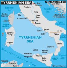 misleadingly translated both pontos and pelagos as ‘ocean’, while the earliest English translation by Thomas Taylor correctly renders them as ‘sea’. Modern translators such as Joseph Warren Wells and a Greek commentator George Sarantitis are both quite happy to agree with Taylor’s translation. However, Peter Kalkavage translates pontos as ‘sea’ but pelagos as ‘ocean’!
For me, there is a very strong case to be made for identifying the Tyrrhenian Sea as the ‘sea’ referred to by Plato in the passage quoted above. However, it was probably F.Butavand, in 1925, who first proposed the Tyrrhenian as the sea described by Plato in his La Veritable Histoire de L’Atlantide[205] .
Pushing the boat out a little further, I note that Rome is situated in Central Italy and by tradition was founded by the twins Romulus and Remus!
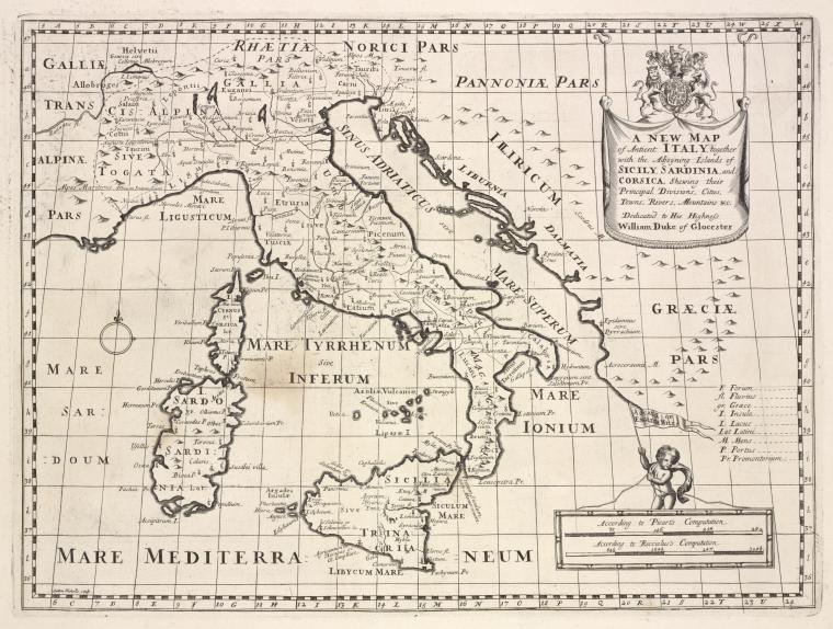
A 1700 map of the Tyrrhenian Sea is available online.
‘Tyrrhenia’ is sometimes used as a geological term to describe a sunken landmass in the Western Mediterranean Basin(b)(c).
(a) (link broken) *
Bardanzellu, Federico
Federico Bardanzellu (1954- ) is a Roman researcher(a) with a special interest in Mediterranean prehistory. His ‘Dolmen Museum’ website(b) has particular relevance for Atlantology, as in it he discusses, in some detail, the Sea Peoples(c) and their connection with Sardinia, Corsica and Sicily as well as the Italian mainland. He claims that Homer’s Odysseus did not sail in the Okeanos beyond Gibraltar but instead voyaged in the Tyrrhenian Sea. He identifies Tarshish with the Sardinian Tharros and places the Pillars of Hercules in the Strait of Sicily on the island of Motya off the west coast of Sicily. Although he refers to Sergio Frau’s location for the ‘Pillars’, he does not specifically mention Atlantis.
Bardanzellu has also published a book on the earliest inhabitants of Italy entitled Gli Antenati Che Vennero dal Mare[1017].
Although his website has not been updated for over a decade, it does include an interesting study of possible astronomical significance that might be deduced from the orientation of the dolmens on both Corsica and Sardinia.(d)
(a) Federico Bardanzellu Home Page (archive.org)
(b) http://www.museodeidolmen.it/
Court de Géblin, Antoine
 Antoine Court de Géblin (1725-1784) was formerly a Protestant pastor who later turned to seek esoteric wisdom through the Tarot! He claimed that the Tarot cards were the work of the ancient Egyptians, being one of their books that escaped the flames that devoured their superb libraries!(a)
According to Joscelyn Godwin[746.36] quoting Fabre d’Olivet, Court believed that Corsica and Sardinia held the remains of Atlantis.