Latest News
Joining The Dots
I have now published my new book, Joining The Dots, which offers a fresh look at the Atlantis mystery. I have addressed the critical questions of when, where and who, using Plato’s own words, tempered with some critical thinking and a modicum of common sense.Read More »
Stavros Papamarinopoulos
Late Bronze Age Collapse
Late Bronze Age Collapse of civilisations in the Eastern Mediterranean in the second half of the 2nd millennium BC has been variously attributed to earthquakes, volcanic eruptions and severe climate change. It is extremely unlikely that all these occurred around the same time by coincidence. Unfortunately, it is not clear to what extent these events were interrelated. As I see it, political upheavals do not lead to earthquakes, volcanic eruptions or drought and so can be safely viewed as an effect rather than a cause. Similarly, climate change is just as unlikely to have caused eruptions or seismic activity and so can also be classified as an effect. Consequently, we are left with earthquakes and volcanoes as the prime suspects for the catastrophic turmoil that took place in the Middle East between the 15th and 12th centuries BC. Nevertheless, August 2013 saw further evidence published, that also blamed climate change for the demise of Bronze Age civilisations in the region.
In 2022, a fourth possible cause emerged from a genetic research project – disease. The two disease carriers in question were the bacteria Salmonella enterica, which causes typhoid fever, and the infamous Yersinia pestis, the bacteria responsible for the Black Death plague that decimated the population of medieval Europe. These are two of the deadliest microbes human beings have ever encountered, and their presence could have easily triggered significant heavy population loss and rampant social upheaval in ancient societies(d).
Robert Drews[865] dismisses any suggestion that Greece suffered a critical drought around 1200 BC, citing the absence of any supporting reference by Homer or Hesiod as evidence. He proposes that “the transition from chariot to infantry warfare as the primary cause of the Great Kingdoms’ downfall.”
Diodorus Siculus describes a great seismic upheaval in 1250 BC, which caused radical topographical changes from the Gulf of Gabes to the Atlantic. (181.16)
This extended period of chaos began around 1450 BC when the eruptions on Thera took place. These caused the well-documented devastation in the region including the ending of the Minoan civilisation and probably the Exodus of the Bible and the Plagues of Egypt as well. According to the Parian Marble, the Flood of Deucalion probably took place around the same time.
Professor Stavros Papamarinopoulos has written of the ‘seismic storm’ that beset the Eastern Mediterranean between 1225 and 1175 BC(a). Similar ideas have been expressed by Amos Nur & Eric H.Cline(b)(c). The invasion of the Sea Peoples recorded by the Egyptians, and parts of Plato’s Atlantis story, all appear to have taken place around this same period. Plato refers to a spring on the Athenian acropolis (Crit.112d) that was destroyed during an earthquake. Rainer Kühne notes that this spring only existed for about 25 years but was rediscovered by the Swedish archaeologist, Oscar Broneer, who excavated there from 1959 to 1967. The destruction of the spring and barracks, by an earthquake, was confirmed as having occurred at the end of the 12th century BC. Tony Petrangelo published two interesting, if overlapping, articles in 2020 in which he discussed Broneer’s work on the Acropolis(e)(f).
A recent review of two books on the subject in the journal Antiquity begins with the following preamble;
“The collapse c. 1200 BC” in the Aegean and eastern Mediterranean—which saw the end of the Mycenaean kingdoms, the Hittite state and its empire and the kingdom of Ugarit—has intrigued archaeologists for decades. As Jesse Millek points out in his book Destruction and its Impact, the idea of a swathe of near-synchronous destructions across the eastern Mediterranean is central to the narrative of the Late Bronze Age collapse: “destruction stands as the physical manifestation of the end of the Bronze Age” (p.6). Yet whether there was a single collapse marked by a widespread destruction horizon is up for debate.” (g)
(b) https://academia.edu/355163/2001_Nur_and_Cline_Archaeology_Odyssey_Earthquake_Storms_article (this is a shorter version of (c) below)
(e) https://atlantis.fyi/blog/platos-fountain-on-the-athens-acropolis
(f) A General Program of Defense | Atlantis FYI
(g) Getting closer to the Late Bronze Age collapse in the Aegean and eastern Mediterranean, c. 1200 BC | Antiquity | Cambridge Core
Schaeffer, Claude Frédérick-Armand
Claude Frédérick-Armand Schaeffer (1898-1982) was a French archaeologist who is probably best known for his work at the Ras Shamra site in 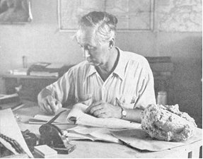 Syria which he identified as the ancient port city of Ugarit. He worked on and wrote about the site from 1929 until his death.
Schaeffer entered the arena of catastrophism in 1948 when he declared[806] that during the Bronze Age, on at least five occasions, widespread catastrophic destructions had taken place throughout the Middle East.
Some chapters from his book, Stratigraphie Comparée et Chronologie de l’Asie Occidentale (III et II. Millénaires), have now been translated and are available online(c).
He attributed these events to seismic activity, which was perhaps related to the ‘seismic storm’ referred to by Stavros Papamarinopoulos in his paper, Plato and the seismic catastrophe in the 12th century BC Athens(b).
It was left to others, such as Velikovsky and René Gallant[0748] to add the possibility of extraterrestrial bombardments.
Plato recorded how the priests of Sais told Solon of successive catastrophes has been cited as a literary parallel to the theories of Schaeffer, Velikovsky and Gallant et al.
Schaeffer and Velikovsky exchanged correspondence(a).
(a) Claude Schaeffer – Professor Claude F.A. Schaeffer of the College de France (archive.org)
(c) https://www.q-mag.org/reading-from-claude-schaeffers-stratigraphie-comparee.html
Mycenaeans
Mycenaean is the name given to the culture of ancient Greece (excluding Crete) during the Late Bronze Age (1500–1100 BC). They were also called Achaeans. The controversial writer Felice Vinci maintains that a Northern European tribe was referred to as Achaeans by Homer and that they migrated south and founded the Mycenaean civilisation.
Among the many geographical identifications of Homeric locations in the Baltic by Vinci is his claim that Mycenae was probably located on the same site as Copenhagen and associated Thebes with Stockholm [019.218]. Compare this with Iman Wilkens‘ claim that Mycenae had been situated in northern France [610.121]!
However, it was Martin Persson Nilsson (1874-1967), a Swedish historian, who was an earlier proponent of a Nordic origin for the Mycenaeans. A Northern European location for Mycenae (and Sparta) has also been proposed by John Esse Larsen, who has specified Hareskov in northeast Denmark(d).
However, recent genetic studies suggest that the mainland Mycenaeans and the Cretan Minoans share a common ancestry with Neolithic populations of what are today Turkey and Greece(c).
Stavros Papamarinopoulos claims [750.73] that the Athens described by Plato in the Critias is an accurate description of Mycenaean Athens and then leaps to the conclusion that because the details of Athens provided by Plato are correct, then it must follow that his depiction of Atlantis is equally reliable! For me, this is an unacceptable non sequitur, as Plato lived in Athens and would have been fully aware of the city’s landmarks and tradition. On the other hand, he had not been to Atlantis, in fact, he was somewhat vague regarding its actual location. Jason Colavito also took issue with Papamarinopoulos’ contention(f).
However, there is evidence of Mycenaean warriors fighting alongside Egyptian soldiers of the 18th Dynasty(e)!
Austen Atkinson in his Impact Earth[109] suggested the possibility that the unexplained ending of the Mycenaean civilisation could be explained as a consequence of Earth’s encounter with Phaëton referred to by Plato (Tim.22c-d).
However, there are current studies(a) being made into the possibility that earthquakes were responsible for the demise of the Mycenaeans and the start of the Greek ‘Dark Ages’.
However, the earthquake theory is also under attack(b), with the proposal that either an uprising or invasion was responsible for the demise of Mycenaean Greece.
A recent outline[226] of the Mycenaean culture has been produced by Rodney Castleden, who has also written about Atlantis.
(b) http://web.archive.org/web/20250215123918/https://www.tornosnews.gr/en/greek-news/culture/30911-new-study-mycenaean-civilization-might-have-collapsed-due-to-uprising-or-invasion.html
(c) https://www.haaretz.com/archaeology/MAGAZINE-mystery-of-where-the-minoans-came-from-solved-1.5439462
(d) http://odisse.me.uk/the-danaan-islands-seeland-and-arcadia.html
(e) https://www.thearchaeologist.org/blog/x4z1qi7hp27q8mjvo74cbzz9uc8irm?rq=abydos
Concentric Rings
The Concentric Rings or other architectural features extracted by artists from Plato’s description of the capital of Atlantis have  continually fascinated students of the story and many have attempted to link them with similar ancient features found elsewhere in the world as evidence of a widespread culture. Stonehenge, Old Owstrey, Carthage and Syracuse have all been suggested, but such comparisons have never been convincing. Diaz-Montexano has recently published(a) an image of a fragment of pottery found near Seville in Spain that shows concentric circles and insists that it is a symbol of Atlantis. Ulf Erlingsson has made a similar claim regarding some concentric circles carved on a stone basin found at Newgrange in Ireland.
Less well-known are the concentric stone circles that are to be found on the island of Lampedusa in the Strait of Sicily(b).
In 1969 two commercial pilots, Robert Brush and Trigg Adams, photographed a series of large concentric circles in about three feet of water off the coast of Andros in the Bahamas. Estimates of the diameter of the circles range from 100 to 1,000 feet. Apparently, these rings are now covered by sand. It is hard to understand how such a feature in such very shallow water cannot be physically located and inspected. Richard Wingate, in his book [0059] estimated the diameter at 1,000 yards. However, the rings described by Wingate were apparently on land, among Andros’ many swamps.
A recent (2023) report has drawn attention to the ancient rock art found on Kenya’s Mfangano Island where a number of concentric circles estimated as 4,000 years old can be seen(q).
Two papers presented to the 2005 Atlantis Conference on Melos describe how an asteroid impact could produce similar concentric rings, which, if located close to a coast, could be converted easily to a series of canals for seagoing vessels. The authors, Filippos Tsikalas, V.V. Shuvavlov and Stavros Papamarinopoulos gave examples of such multi-ringed concentric morphology resulting from asteroid impacts. Not only does their suggestion provide a rational explanation for the shape of the canals, but it would also explain the apparent over-engineering of those waterways.
At the same conference, the late Ulf Richter presented his idea [629.451], which included the suggestion that the concentric rings around the centre of the Atlantis capital had a natural origin. Richter has proposed that the Atlantis rings were the result of the erosion of an elevated salt dome that had exposed alternating rings of hard and soft rock that could be adapted to provide the waterways described by Plato.
Georgeos Diaz-Montexano has suggested that the ancient city under modern Jaen in Andalusia, Spain, had a concentric layout similar to Plato’s description of Atlantis. In August 2016 archaeologists from the University of Tübingen revealed the discovery(i) of a Copper Age, Bell Beaker People site 50km east of Valencina near Seville, where the complex included a series of concentric earthwork circles.

A very impressive example of man-made concentric stone circles, known in Arabic as Rujm el-Hiri and in Hebrew as Gilgal Refaim(a), is to be found on the Golan Heights, now part of Israeli-occupied Syria. It consists of four concentric walls with an outer diameter of 160metres. It has been dated to 3000-2700 BC and is reputed to have been built by giants! Mercifully, nobody has claimed any connection with Atlantis. That is until 2018 when Ryan Pitterson made just such a claim in his book, Judgement of the Nephilim[1620].
Jim Allen, in his latest book, Atlantis and the Persian Empire[877], devotes a well-illustrated chapter to a discussion of a number of ‘circular cities’ that existed in ancient Persia and which some commentators claim were the inspiration for Plato’s description of the city of Atlantis. These include the old city of Firuzabad, which was divided into 20 sectors by radial spokes, as well as Ecbatana and Susa, both noted by Herodotus to have had concentric walls. Understandably, Allen, who promotes the idea of Atlantis in the Andes, has pointed out that many sites on the Altiplano have hilltops surrounded by concentric walls. However, as he seems to realise that to definitively link any of these locations with Plato’s Atlantis, a large dollop of speculation is required.
Rodney Castleden compared the layout of Syracuse in Sicily with Plato’s Atlantis, noting that the main city “had seen a revolution in its defensive works, with the building of unparalleled lengths of circuit walls punctuated by numerous bastions and towers, displaying the city-state’s power and wealth. The three major districts of the city, Ortygia, Achradina and Tycha, were surrounded by three separate circuit walls; Ortygia itself had three concentric walls, a double wall around the edge and an inner citadel”.[225.179]
Dale Drinnon has an interesting article(d) on the ‘rondels’ of the central Danubian region, which number about 200. Some of these Neolithic features have a lot in common with Plato’s description of the port city of Atlantis. The ubiquity of circular archaeological structures at that time is now quite clear, but they do not demonstrate any relationship with Atlantis.
The late Marcello Cosci based his Atlantis location on his interpretation of aerial images of circular features on Sherbro Island, but as far as I can ascertain, this idea has gained little traction.
One of the most remarkable natural examples of concentric features is to be found in modern Mauritania and is known as the Richat Structure or Guelb er Richat. It is such a striking example that it is not surprising that some researchers have tried to link it with Atlantis. Robert deMelo and Jose D.C. Hernandez(o) are two advocates, along with George S. Alexander & Natalis Rosen who were struck by the similarity of the Richat feature with Plato’s description and decided to investigate on the ground. Instability in the region prevented this until late 2008, when they visited the site, gathering material for a movie. The film was then finalised and published on their then newly established website in 2010(l), where the one-hour video in support of their thesis can be freely downloaded(m).
In 2008, George Sarantitis put forward the idea that the Richat Structure was the location of Atlantis, supporting his contention with an intensive reappraisal of the translation of Plato’s text(n). He developed this further in his Greek language 2010 book, The Apocalypse of a Myth[1470] with an English translation currently in preparation.
However, Ulf Richter has pointed out that Richat is too wide (35 km), too elevated (400metres) and too far from the sea (500 km) to be seriously considered as the location of Atlantis.
A dissertation by Oliver D.Smith has suggested(e) the ancient site of Sesklo in Greece as the location of Atlantis, citing its circularity as an important reason for the identification. However, there are no concentric walls, the site is too small and most importantly, it’s not submerged. Smith later decided that the Atlantis story was a fabrication!(p)
Brad Yoon has claimed that concentric circles are proof of the existence of Atlantis, an idea totally rejected by Jason Colavito(j).
In March 2015, the UK’s MailOnline published a generously illustrated article(g) concerning a number of sites with unexplained concentric circles in China’s Gobi Desert. The article also notes some  superficial similarities with Stonehenge. I will not be surprised if a member of the lunatic fringe concocts an Atlantis theory based on these images. (see right)
Paolo Marini has written Atlantide:Nel cerchio di Stonehenge la chiave dell’enigma (Atlantis: The Circle is the Key to the enigma of Stonehenge) [0713]. The subtitle refers to his contention that the concentric circles of Atlantis are reflected in the layout of Stonehenge!
In 2011, Shoji Yoshinori offered the suggestion that Stonehenge was a 1/24th scale model of Atlantis(f). He includes a fascinating image in the pdf.
This obsession with concentricity has now extended to the interpretation of ancient Scandinavian armoury, in particular items such as the Herzsprung Shield(c).
For my part, I wish to question Plato’s description of the layout of Atlantis’ capital city with its vast and perfectly engineered concentric alternating bands of land and sea. This is highly improbable as the layout of cities is invariably determined by the natural topography of the land available to it(h). Plato is describing a city designed by and for a god and his wife and as such, his audience would expect it to be perfect and Plato did not let them down. I am therefore suggesting that those passages have been concocted within the parameters of ‘artistic licence’ and should be treated as part of the mythological strand in the narrative, in the same way that we view the ‘reality’ of Clieto’s five sets of male twins or even the physical existence of Poseidon himself.
Furthermore, Plato was a follower of Pythagoras, who taught that nothing exists without a centre, around which it revolves(k). A concept which may have inspired him to include it in his description of Poseidon’s Atlantis.
(b) Megalithic Lampedusa (archive.org)
(c) Atlantis & Megalithkulturen
(d) See: Archive 3595
(e) http://web.archive.org/web/20220604174934/https://atlantipedia.ie/samples/archive-3062/
(f) https://www.pipi.jp/~exa/kodai/kaimei/stonehenge_is_small_atrantis_eng.pdf
(i) First Bell Beaker earthwork enclosure found in Spain | ScienceDaily (archive.org)
(j) https://www.jasoncolavito.com/blog/rings-of-power-do-concentric-circles-prove-atlantis-real
(k) Pythagoras and the Mystery of Numbers (archive.org)
(l) Visiting Atlantis | Gateway to a lost world (archive.org)
(m) https://web.archive.org/web/20171022134926/https://visitingatlantis.com/Movie.html
(n) https://platoproject.gr/system-wheels/ https://platoproject.gr/page13.html (offline Nov.2015) https://web.archive.org/web/20230208173545/http://platoproject.gr/system-wheels/
(o) https://blog.world-mysteries.com/science/a-celestial-impact-and-atlantis/ (item 11)
(p) https://shimajournal.org/issues/v10n2/d.-Smith-Shima-v10n2.pdf
Phaëton
Phaëton in Greek mythology was the son of Helios the Greek sun god. Phaëton was also the name given to a comet that impacted or had a close encounter with the Earth in the 13th century BC. The Egyptians knew this comet as Sekhmet. Ancient inscriptions record that some of the consequences of this dramatic encounter were the drying up of the Nile and the desertification of Libya.
Michel-Alain Combes has noted(j) that Phaëton has also been associated “with Anat in Syria, the star of Baal in Canaan (Palestine and Phenicia), Absinthe, The star of the Apocalypse) among the Hebrews, Surt in the countries of the north.” He also suggests that the legends of Typhon (Hesiod) and Phaeton (Ovid), although usually thought to refer to separate events, are just different versions of the same encounter with a comet in the late 13th century BC.
Günter Bischoff has published two lengthy articles(n)(o) on the Atlantisforschung website, which includes a comment that might account for the number of locations where apparent sightings of the comet were reported. “Now it is easy to explain why Phaethon should have been sighted over Greece, Egypt, Syria, India and other countries. During its orbits lasting several days, it will have flown over many inhabited areas on its elliptical orbit. Some observers may even have seen it several times and from different directions.”
A 2012 paper by Peter James and M. A. van der Sluijs entitled ”Silver’: A Hurrian Phaethon’ (l) concluded that “there is an attractive pattern of correspondences between the well-known Greek myth of Phaethon and the Hurrian myth of Silver.” Silver was a character in Hurrian mythology, also known as Ushu.
Interestingly, Plato records in Timaeus how Phaëton caused immense devastation, but does not link it directly with the destruction of Atlantis. But the context implies an event that was in the distant past, considerably earlier than Solon. Some ancient authorities, such as Eusebius and Isidore of Seville, have associated Phaëton with the time of Moses.
The poet Goethe considered the story of Phaëton to have had a real astronomical origin.
Franz Xavier Kugler was a Jesuit priest who spent over thirty years studying ancient astronomical texts written in cuneiform. In 1927, he published a paper in which he concluded that a 1500 BC asteroidal impact in the Mediterranean inspired the story of Phaëton(r), an idea that could support the theories of Fatih Hodžic.
Immanuel Velikovsky has quoted from several of Kugler’s books in Worlds in Collision(t). In 1975, Malcolm Lowery published a more critical view of Kugler’s theories(u), concluding with the comment “thus we see in Kugler the triumph of preconceived ideas over objective investigation of all available evidence – the more surprising as Kugler could accept one interpretation of Plato to back up one aspect of his theory, but was unable to see its obvious similarity to Celsus and Manilius. In the last reckoning, it seems, he was unable to escape the yoke of uniformitarianism.”
More recently, Bob Kobres has written several articles on the subject of Phaëton having a cometary origin(k). Some of these papers can be found on the Internet(a). Kobres dates this Phaëton event to around 1200 BC.
Stavros Papamarinopoulos from the University of Patras in Greece presented a paper to the 2005 Atlantis Conference held on Melos in which he linked Plato’s Phaëton with an encounter between the earth and cometary fragments around 1200 BC.
Emilio Spedicato opted for 1447 BC as the likely date of the Phaëton explosion. He describes this as a super-Tunguska event, which exploded over southern Denmark(m). He further contends that the after-effects assisted the Israelite Exodus from Egypt.
Spedicato’s identification is comparable with Jürgen Spanuth’s idea that Phaëton was a fragment of Halley’s Comet. Two other followers of Spanuth, Günter Bischoff and Walter Stender, have written extensive papers, in German, on a meteorite impact with Northern Europe around 1220 BC, which they identify as Phaëton(c). The same interpretation has been applied specifically to Lake Chiemgau in S.E. Bavaria and is expanded on in papers by Barbara Rappenglück among many others(d)(f).
The late Bernhard Beier published an article on the Atlantisforschung website regarding Spanuth’s Phaeton theory that proposes a North Sea impact around 4.5km south of Helgoland with the consequent destruction of Atlantis. Beier concludes his comments with “Spanuth’s assumption that the Phaethon legend represents a mythical representation of catastrophic events from pre-Hellenic times corresponds exactly to Plato’s view of things and can therefore still be regarded as open to discussion. His chronological assignment of these events to the end of the ‘Bronze Age’ still seems worthy of discussion. On the other hand, the equation of the assumed Phaethon 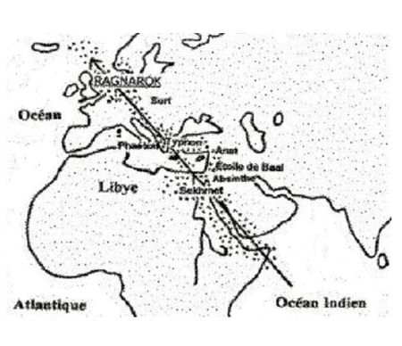 impact with the Atlantis catastrophe, which he made quite naturally and without further ado, lacks any exegetical basis, even if it may initially appear quite logical in the context of Spanuth ‘s theory.”(p) There are aspects of the Phaëton story that are still debated. Was the Phaëton of Greek mythology inspired by a close encounter with a comet? Did it destroy Atlantis? Are we dealing with an impact or just a very close encounter? What was the flight path of the comet? One suggested route is shown here, where it was given different names along the way.
Holger Kalweit, who also follows Spanuth in identifying Heligoland as a remnant of Atlantis, claims it was destroyed in 1222 BC by Phaëton.
Clube & Napier [0290] have proposed a slightly later date of 1369 BC for the encounter with Phaëton.
Dale Drinnon has argued(g) against any connection between Phaeton and the destruction of Atlantis, saying “There are two different kinds of catastrophes being described and distinguished from one another and the Phaethon event is categorically differentiated from the Destruction of Atlantis in the Atlantis dialogues of Plato. There is no good reason to equate the two and certainly no textual justification for doing so.”
Allan & Delair refer to the central cause of the catastrophe described in their book[014] as Phaëton, which they claim was cosmic ejecta from a supernova in the Vela constellation. Maurice A. Williams, in his review(q) of their book, noted how the authors deduced that ancient Mesopotamian observers named this cosmic intruder Marduk, as it caused great disruption in the Solar System, including the destruction of the planet ‘Tiamat’ creating the Asteroid Belt and capturing Tiamat’s satellite ‘Kingu’, which in turn disintegrated near Earth, causing the biblical Deluge. This deadly journey was also seen by the Greeks and called Phaëton by them.
Amanda Laoupi offers an extensive article on the history of the Phaëton myth and its interpretation in both ancient and modern times.
Phaëton was also the name given by Johann Gottlieb Radlof (1775-1829) to a planet that he believed disintegrated after a collision with a comet, within human memory, resulting in the asteroid belt.
Today, we have an asteroid called 3200 Phaeton, which is the source of the annual Geminid meteor shower(s).
(a) Comet Phaethon’s Ride (defendgaia.org)
(b) https://www.migration-diffusion.info/article.php?year=2011&id=259
(c) Wayback Machine (archive.org)
(d) http://impact-structures.com/news/Stoettham_c.pdf
(f) https://guginew.blogspot.ie/2011/09/fall-of-phaethon-greco-roman-geomyth.html
(g) http://web.archive.org/web/20191017005623/https://atlantipedia.ie/samples/archive-3605/
(j) http://www.astrosurf.com/macombes/Article_Sekhmet,_Phaeton,_Surt_et_les_autres.htm (French)
(k) http://web.archive.org/web/20200215123340/https://atlantipedia.ie/samples/archive-3365-2/
(l) https://www.researchgate.net/publication/274336666_’Silver’_A_Hurrian_Phaethon
(m) https://interval.louisiana.edu/conferences/2007_Stenger/Slides_of_talks/mose8-6.pdf
(t) https://web.archive.org/web/20251206125852/https://www.velikovsky.info/franz-xaver-kugler/
(u) “F. X. KUGLER — ALMOST A CATASTROPHIST”) (defendgaia.org)
Papamarinopoulos, Stavros
Stavros Papamarinopoulos is a retired Professor of Applied Geophysics, formerly at the University of Patras in Greece. In 2003 he led a team from his university in an attempt to locate the tomb of Alexander the Great in the cemetery quarter of Alexandria.
 Papamarinopoulos was one of the organisers of the Atlantis Conferences of 2005 [0629], 2008 [0750] and 2011. He was also the editor of the published proceedings of those conferences. Furthermore, he delivered a number of papers to all three conferences. I am informed that after a delay of many years, the publication of the proceedings of the third conference is now (2024) imminent.
In 2024, Papamarinopoulos is currently (2024) the president of the Society for the Study of the Ancient Hellenic Mythology (EMAEM)(r). I’m informed that the “society is a non-profit association being entirely supported by its friends and members, aiming among other topics to the elaboration and promotion of matters associated with the Ancient Hellenic Mythology, which are highlighted by publishing books and papers in international journals and carrying out monthly public lectures and meetings by distinguished scholars, researchers and academics.” The society will be linking to Atlantipedia in the near future.
Mark Adams, author of Meet Me in Atlantis[1070] describes Papamarinopoulos as “the world’s most respected Atlantis expert”(h).
In his paper A Bronze Age Catastrophe in the Atlantic Ocean?, he points out some of the pitfalls associated with the interpretation of prehistoric events when using the language of 4th century B.C. “For instance, a literary differentiation between ‘island’ and ‘peninsula’ did not exist in alphabetic Greek before Herodotus’ in the 5th century B.C. Similarly, there was no distinction between the coast and an island in Egyptian writing systems, up to the 5th century B.C.” Papamarinopoulos maintains that a lack of knowledge of such linguistic shortcomings has been used unwittingly by many who deny the existence of Atlantis.
Papamarinopoulos personally supports the idea of an Iberian Atlantis(f)(g). He presented this view in a series of six papers(b)(j-o) presented to the 2010 International Geological Congress in Patras, Greece. Papamarinopoulos has written several other papers, including one which discusses Phaeton as a comet and its possible coincidence with the Trojan War(a).
Stavros Papamarinopoulos at the 2005 Atlantis Conference highlighted(p) the part played by earthquakes in the description of the ancient Athenian Acropolis in the Atlantis narrative, which he saw as part of a 50-year ‘seismic storm’ which ravaged the Eastern Mediterranean around the 12th century BC [629.499]. Amos Nur & Eric H. Cline discuss the same intense seismic activity in a paper on the Academia.edu website(q).
Papamarinopoulos is also co-author with John S. Kopper of a paper(c) which concluded that there is “a strong correlation between times of abrupt physical and cultural changes in man and reversals of the Earth’s magnetic field.”
In 2012, Papamarinopoulos et al. published a paper(d)(e) that carefully analyses astronomical data, enabling them to conclude that a solar eclipse of 30th October 1207 BC occurred just five days after Homer’s Odysseus returned to Ithaca. Anne-Marie de Grazia, Alfred’s wife, published a paper endorsing Papamarinopoulos’ dating(s).
In the book Science and Technology in Homeric Epics(i) Papamarinopoulos has a chapter entitled Atlantis in Homer and Other Authors Prior to Plato, which was based on a paper presented at the international symposium, Olympia, Greece, August 27–30, 2006.
(b) https://www.researchgate.net/search?q=ATLANTIS%20IN%20SPAIN%20I
(c) Human Evolution and Geomagnetism on JSTOR
(d) (PDF) A new astronomical dating of the Trojan war’s end | Stavros P Papamarinopoulos – Academia.edu
(e) The exact date of the return of Odysseus to Ithaca (q-mag.org)
(f) https://atlantis.fyi/sources/atlantis-in-spain-part-v
(g) https://ejournals.epublishing.ekt.gr/index.php/geosociety/article/view/11164/11216
(i) https://link.springer.com/chapter/10.1007%2F978-1-4020-8784-4_37
(j) (PDF) ATLANTIS IN SPAIN II (researchgate.net)
(k) (PDF) ATLANTIS IN SPAIN III (researchgate.net)
(l) (PDF) ATLANTIS IN SPAIN IV (researchgate.net)
(m) (PDF) ATLANTIS IN SPAIN I (researchgate.net)
(n) (PDF) ATLANTIS IN SPAIN VI (researchgate.net)
(o) (PDF) ATLANTIS IN SPAIN V (researchgate.net)
(r) https://emaem.gr (link broken)
(s) https://www.q-mag.org/the-exact-date-of-the-return-of-odysseus-to-ithaca.html
Island, Peninsula or Continent?
Island, Peninsula or Continent? Advocates of a continental rather than island identification for Atlantis have to contend with the fact that Plato never referred to Atlantis as a continent; instead he used the Greek words for ‘island’, namely ‘nesos’ and ‘neson’. Their line of argument is that these words in addition to ‘island’ or ‘islands’ can also mean “islands of an archipelago” or “peninsula”. Furthermore, it is claimed that the ancient Greeks had no precise word for ‘peninsula’.
Gilles le Noan[912], quoted by Papamarinopoulos[629.558], has offered evidence that there was no differentiation in Greek between ‘island’ and ‘peninsula’ until the time of Herodotus in the 5th century BC. In conversation with Mark Adams[1070.198] he explains that in the sixth century BC, when Solon lived, nesos had five geographic meanings. “One, an island as we know it. Two, a promontory. Three, a peninsula. Four,
Elena P. Mitropetrou a Greek archaeologist at the University of Patras, delivered two papers to the 2008 Atlantis Conference in Athens [750]. She also pointed out that in the 6th century BC, the Greek word nesos was employed to describe an island, but also, a peninsula or a promontory. Mitropetrou herself considers the Iberian peninsula to be the ‘island of Atlantis.’
Robert Bittlestone, in his Odysseus Unbound [1402.143] also notes that “nesos usually means an island whereas cheronesos means a peninsula, but Homer could not have used cheronesos when referring to the peninsula of Argostoli for two very good reasons. First, it cannot be fitted into the metre of the epic verse and second, the word hadn’t yet been invented: it doesn’t occur in Greek literature until the 5th century BC.”
Another researcher, Roger Coghill, echoed the views of many when he wrote on an old webpage that “To the Greeks peninsulae were the same as islands, so the Peloponnesian peninsula was “the island of Pelops” and the Chersonnese was to them “the island of Cherson”. Similarly in describing a place found after escaping the Pillars of Hercules, Plato quite normally describes the Lusitanian coast (modern Portugal) as an “island”, reached, he clearly says, after passing Cadiz”.
Johann Saltzman claimed that ‘nesos’ did not mean ‘island’ or ‘peninsula’ but ‘land close to water’. However, I would be happier sticking to the respected Liddell & Scott’s interpretation of island or peninsula. If Saltzman is correct, what word did the Greeks use for island?
The Modern Greek word for peninsula is ‘chersonesos’ which is derived from ‘khersos’ (dry) and ‘nesos’ (island) and can be seen as a reasonable description of a peninsula. It is worth noting that the etymology of the English word ‘peninsula’ is from the Latin ’paene’ (almost) and ’insula’ (an island).
Jonas Bergman maintains that the Greek concept of ‘island’ is one of detachment or isolation. He also points out that the original Egyptian word for ‘island’ can also mean lowland or coastland because the Egyptians had a different conception of ’island’ to either the ancient Greeks or us. Some commentators have claimed that the Egyptians of Solon’s time described any foreign land as an island.
Eberhard Zangger offers another correction of the Atlantis mystery: If one compares the land-sea distribution in Egypt and in the Aegean Sea, it becomes obvious why the Egyptians used at that time the expression “from the islands”. While today the word “island” has a clear meaning, this was not the case in the late Bronze Age. For the Egyptians more or less all strangers came from the islands. As there had been practically no islands in Egypt, the ancient Egyptian language did not have any special character for it. The hieroglyphic used for “island” was also meaning “sandy beach” or “coast” and was generally used for “foreign countries” or “regions on the other side of the Nile”.
A contributor to the Skeptic’s Dictionary(b) has added “I remind you that the Greek definition of “island” paralleled that of “continent.” To the Greeks, Europe was a continent. West Africa was an island, especially since it was cut off from the rest of what we now call “Africa” by a river that ran south from the Atlas mountains and then west to what is now the western Sahara. This now dry river was explored by Byron Khun de Prorok in the 1920s.”
Reginald Fessenden wrote: “One Greek term must be mentioned because it has given rise to much confusion. The word ‘Nesos’ is still translated as meaning ‘island’ but it does not mean this at all, except perhaps in late Greek. The Peloponnesus is a peninsula. Arabia was called a “nesos” and so was Mesopotamia”. This ambiguity in the written Greek and Egyptian of that period was highlighted at the 2005 Atlantis Conference by Stavros Papamarinopoulos.
Werner Wickboldt pointed out at the same conference that Adolph Schulten, in the 1920s referred to a number of classical writers who used the term ‘nesos’ in connection with the Nile, Tiber, Indus and Tartessos, all of which possessed deltas with extensive networks of islands.
To confuse matters even further, there have been several theories based on the idea that the ‘island’ of Atlantis was in fact land surrounded by rivers rather than the sea. These include Mesopotamia in Argentina proposed by Doug Fisher, the Island of Meroë in Sudan suggested by Thérêse Ghembaza and a large piece of land bound by the Mississippi, Ohio, and Potomac rivers offered by Henriette Mertz. However, none of these locations matches Plato’s description of Atlantis as a maritime trading nation with a naval fleet of 1200 ships, nor do any of them explain how they controlled the Mediterranean as far as Egypt and Tyrrhenia.
Another Atlantis-island variant is based on the existence of a large inland sea where the Sahara now exists. Gerald Wells has proposed that the Atlas Mountains, in what is now Algeria, were effectively an island isolated by this inland sea to the south, the Mediterranean to the north and the Atlantic Ocean to the west. He claims that the City of Atlantis was situated on the Hill of Garet-el-Djeter.
Related to Wells’ theory is the highly technical approach of Michael Hübner who located Atlantis on the Souss Massa Plain of Morocco, where today the plain and its adjacent valleys are called ‘island’ by the native Amazigh people.(Constraint 2.2.1.2 R102)[632].
The waters around Plato’s island are indeed muddy!