Latest News

Joining The Dots
I have now published my new book, Joining The Dots, which offers a fresh look at the Atlantis mystery. I have addressed the critical questions of when, where and who, using Plato’s own words, tempered with some critical thinking and a modicum of common sense.Read More »
Cyclades
Hawk, Alex
Alex Hawk has supported the Minoan Hypothesis for the past two decades on a rather slim website(a). He claims that Atlantis was known as Keftiu to the Egyptians and he places the Pillars of Heracles in the Cyclades.
(a) http://web.archive.org/web/20221024095746/https://www.angelfire.com/hi/alhawk/atlanthira.html
Gaki-Papanastassiou, Kalliopi
Kalliopi Gaki-Papanastassiou, a geologist at the University of Athens, was the lead author of a 2010 paper entitled Palaeogeographic Evolution of the Cyclades Islands (Greece) During the Holocene(a). In it she suggests that the Cycladic Islands in the Aegean Sea was the location of the lost Atlantis, probably situated between Naxos, Paros and Antiparos.
(a) https://link.springer.com/chapter/10.1007/978-1-4020-9720-1_28
Poseidonia
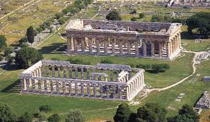 Poseidonia was the original name for the Roman city of Paestum, situated south of Naples, founded by Greek colonists around 600 BC. It was partly flooded and largely forgotten until a number of well-preserved Greek temples were rediscovered in the 18th century.
Coincidentally, the city was established in a region of southern Italy, described by Plato as being part of Atlantean territory!
Thomas Major (1720-1799), a royal engraver, visited the site in 1767 and described the ruins of Paestum in an illustrated 1768 book, The Ruins of Paestum, otherwise Posidonia, in Magna Graecia [1644].
Poseidonia, is also the name of a village on the Cycladic island of Syros.
Zamarro, Paulino
Paulino Zamarro, born in 1947, in Cantalejo, Segovia, Spain and is now living  in Madrid. He is an industrial engineer specialising in chemistry and has worked for over twenty years on environmental studies. Among his ecological publications, in Spanish, is a monograph on a wetland near his birthplace – The Lagoons of Catalejo.
He is also the author of Del Estrecho de Gibraltar a la Atlantida (From the Strait of Gibraltar to Atlantis)[0024], in which he puts forward a number of radical ideas. He first proposes that an isthmus at the Strait of Gibraltar had been created as a result of silting. He then claims that at the end of the last Ice Age this landbridge was breached leading to the destruction of Atlantis. Both Strato and Seneca refer to the breaking of the Gibraltar dam. Zamarro dates the breach to circa 5500 BC.
He places Atlantis in the Cyclades in the Eastern Mediterranean, which had originally been a single landmass and identifies a tiny island called Pori north of the island of Antikythera as the site of the Pillars of Heracles. Fifteen years later Christos A. Djonis proposed a location in the same region without giving any credit to Zamarro. He highlighted the multiplicity of locations that have been designated as the site of the ‘Pillars’.
 To-date the book has only been published in Spanish, although Zamarro is anxious to have it published in English. His ideas are summarised on a website(a) promoting the book, which can be translated by your browser.
Zamarro has recently added a further site(b) where the first 100 pages of his book (in Spanish) can be read online. A revised second edition of his book was published in 2012 with the slightly shortened title of De Gibraltar a la Atlántida and also available in the Kindle format.
>March 4th 2021 saw Pablo Rodríguez Cantos publish a review(c) (in Spanish) of Zamarro’s book, which can be read in English here.<
(a) https://atlantida.webatu.com/ (offline July 2016) See: https://web.archive.org/web/20130528153632/https://atlantida.webatu.com/
(b) https://www.atlantidaegeo.com/ (link broken Jan. 2019) See: https://web.archive.org/web/20180806011857/https://www.atlantidaegeo.com
Santorini
 Santorini, earlier known as Thera, is claimed by tradition to have received its name from Theras, a 9th century BC invader. It is the most southerly member of the Cyclades group of islands in the Aegean Sea. It is named after St. Irene of Thessaloniki. In ancient times it was known as Calliste (Most Beautiful) and Stronghyle. One source states that for a short period in the 16th century a Jew named Nazi (sic) owned Thera. A potted history of the island was compiled by Professor Christos Doumas(c).
Many writers over the past century have supported the idea that Atlantis was a Minoan society that was destroyed when Thera erupted violently in the second millennium BC. This is discussed more fully under Thera.
The archaeological site near the village of Akrotiri on the south of the island was closed nearly seven years ago after a ceiling collapsed killing one tourist and injuring six others. Now the site is due to open again in April 2012(a) ironically just as evidence is mounting of increased volcanic activity in the Santorini caldera(b).
Rather unexpectedly, I came across an article about a link between Santorini and vampires by Paul Devereux, not surprisingly in the Fortean Times of April 2013.
May 1st 2019 saw the opening of a new museum on Santorini, called The Lost Atlantis Experience.(d)
Santorini is also the home of Atlantis Books, which has been described as “one of Europe’s most enchanting bookstores” and has now become a tourist attraction in its own right.(e)
(b) https://greece.greekreporter.com/2012/03/13/volcanic-island-of-santorini-shows-activity/
(d) https://www.atlantis-scout.de/atlantis_newsl_archive.htm
(e) https://www.nytimes.com/2019/10/27/books/atlantis-books-bookstore-santorini.html
Pastras, Diamantis
Diamantis Pastras, a Greek-Australian confectioner, presented to the Atlantis Conference in 2005[629.295]his theory that Atlantis had been situated in the Cyclades combined with Astipalea in the Dodecanese, which he maintains constituted a larger landmass 3,500 years ago. He bases his theory on an ancient map from the Egyptian Book of the Dead in the British Museum. Pastras, who first formulated his theory in 1989, submitted a second paper to the 2008 Atlantis Conference in Athens.
Lambeck, Kurt L.
 Kurt L. Lambeck (1941- ) is a Professor of Geophysics at The Australian National University in Canberra. He has carried out a study in many parts of the world of sea level changes and together with A. Purcell presented a paper to the 2005 Melos Atlantis Conference with the tantalising sub-title of “Was Atlantis on the doorstep of Athens”.
Lambeck particularly charts the reduction of the Cyclades from a landmass of approximately 160 x 85 km (13,600 km2) to the archipelago we know today, which has an area of 2,572 km2.
He suggests that a memory of the break-up of this large landmass may have been the source of Plato’s Atlantis. His findings in the Aegean have been published in Antiquity[430] and maps of sea level changes, based on his investigations, are also available on the Internet. It is interesting to compare Lambeck’s findings with the theory of Paulino Zamarro or Djonis, who firmly places Atlantis in the Aegean.
Lambeck’s sea level data has been harshly criticised by Izabol Apulia(d), who has developed a large series of maps showing the ancient coastlines of most Mediterranean islands at various stages since the Last Glacial Maximum.
Lambeck has also studied the Persian Gulf and concluded that it had been a fertile valley that was inundated after the last Ice Age was ending, forcing the inhabitants to move inland and leading to the establishment of the intriguing Mesopotamian civilisations such as that of the Sumerians. This flooding of the Persian Gulf(b) may have inspired the Epic of Gilgamesh, which contains a Deluge story, accepted by many, to be an earlier version of the Biblical flood of Noah. The December 2010 issue of Current Anthropology discusses this subject and suggests that the flooding of both the Persian Gulf and the Black Sea took place around the same time(c).
In 2004, Jim Teller, a geologist at the University of Manitoba and his team offered evidence for the inundation of the Persian Gulf at the end of the last Ice Age. The devastation that was caused to the communities could have inspired the flood stories found in early historical documents(a).
(a) icult — Noah’s flood: the Canada connection (treyf.com)
(b) Wayback Machine (archive.org)
(c) https://www.seeker.com/ancient-desert-oasis-echoes-eden-1765150780.html
(d) http://web.archive.org/web/20191216092056/https://atlantipedia.ie/samples/archive-2566/
Crete
Crete was until recently thought to have been first settled around 7000 BC. However, excavations at nine sites in 2008 and 2009 have revealed double-edged hand axes dated to “at least” 130,000 years ago. This discovery has suggested(a) that Stone Age man had developed seafaring abilities.
There is something of a consensus that Crete was known as Keftiu to the ancient Egyptians. Some others have been in favour of identifying Keftiu with Cyprus, among whom, Immanuel Velikovsky argued(e) that if Cyprus was not Caphtor, then it is the only island of any importance in the Eastern Mediterranean not mentioned in the Bible [039.210]. Caphtor/Keftiu: A New Investigation [1052] by John Strange also supports this identification with Cyprus.
Sir Arthur Evans, knighted for his archaeological finds on Crete, excavated at Knossos from 1900-1905, leading to the discovery of the famous ‘palace’ there. Evans saw Knossos as an administrative centre, although it had no defensive features, which might be expected. In the 1970’s Hans Georg Wunderlich (1928-1974) following the views of Oswald Spengler, proposed in The Secret of Crete[826] , that the ‘palace’ was in fact a mortuary temple. This idea has more recently been considered by the late Philip Coppens(c).
As early as 1910, the Rev. James Baikie suggested Crete as the location of Atlantis. A year earlier K.T. Frost, outlined parallels between Atlantis and the Minoan empire. In the 1920’s, Joseph McCabe, a former Catholic priest, was also convinced that Crete was the location of Atlantis. More decades were to pass before Dr Angelos Galanopoulos developed the idea further[0263][0264]. There has been doubt that the decline of the Minoan civilisation in the 2nd millennium BC was linked with Theran explosion. Nevertheless, Bacon and Galanopoulos admit that a Minoan explanation for the Atlantis story ‘is correct in all points’ except date, dimensions and location of ‘Pillars’! Many commentators have added reasons to support the Minoan Hypothesis.
 James Mavor records[265] how a stone was discovered on Thera with the name Eumelos inscribed on it in archaic Greek. However, it would be unwise to read too much into a single isolated object.
J. V. Luce lists a number of interesting similarities between Crete and Plato’s description of Atlantis[120].
*Atlantis was the way to other islands. This is an accurate description of Crete as the gateway to the Cyclades and Greece.
*The palace of the Atlanteans is on a low hill 50 stadia inland and near to a fertile plain is a good description of Knossos.
*The description of the land fits perfectly with the southern coast of Crete.
*There were bulls hunted without weapons, which is characteristic of Minoan Crete.
*The construction of the buildings matches Knossos.
Rodney Castleden[0225] uses statistics to demonstrate that Minoan Crete was closer to Plato’s description of Atlantis than previously thought.
Marjorie Braymer[198] highlights the fact that the Cretan Mesara Plain is oblong in shape and one tenth of the dimensions of the plain mentioned by Plato. A fact that gains in importance if a tenfold exaggeration of the dimensions by Plato is accepted.
J. G. Bennett has gone further and argued strongly for a linkage of the destruction of Minoan civilisation, with the Flood of Deucalion, the Biblical Exodus and the obliteration of Plato’s Atlantis. Bennett quotes Plato’s Laws (705.15), which speaks of a significant migration from Crete, as evidence for a major catastrophe on the island.
In April 2004, a BBC Timewatch programme looked at a possible link between Crete and Atlantis, focussing on evidence of ancient tsunami damage on the island that they linked to the eruption of Thera. This idea has been refuted by W. Shepard Baird, who offers a pyroclastic surge as a more credible explanation(b). In 2010, the BBC broadcasted another documentary supporting the Minoan Hypothesis, although not very convincingly in the opinion of this compiler.
On the other hand, Peter James points out that there is no connection in Greek mythology between Crete and Atlas. Further objections include the fact that no ancient canals have been found on Crete, the island did not sink and the failure of Plato to simply name Crete as the location of his Atlantis, even though it was well-known to the mainland Greeks.
Recently Gavin Menzies has, unsuccessfully, in my view, attempted to breathe new life into the Minoan Hypothesis in The Lost Empire of Atlantis.
An even less impressive effort to support a Minoan Atlantis is a slender work by Lee R. Kerr, entitled Griffin Quest – Investigating Atlantis [807], who also published an equally useless sequel, Atlantis of the Minoans and Celts[1104].
(a) https://www.stonepages.com/news/archives/003678.html
(b) The ‘Sinking Atlantis’ Tsunami Myth Debunked (archive.org)
(c) http://web.archive.org/web/20220517071320/http://atlantipedia.ie/samples/archive-2133/
(d) https://trove.nla.gov.au/ndp/del/article/204059231?searchTerm=Atlantis discovered&searchLimits=
Cyclades
The Cyclades are a group of twenty-four islands, which encircle the sacred isle of Delos, in the Greek Aegean Sea. Vasilios Kapsimalis from the Hellenic Centre for Marine Research related to the 2005 Atlantis conference how the Cyclades, which originally had a land surface of around 7000 sq kilometres, lost 75% of their area following the raising of sea levels after the last Ice Age. A pre-Greek civilisation flourished there,  which had no written language, but is probably best known today for its distinctive marble figurines. The origin of the Cycladic culture is hotly debated with Egyptian and/or Phoenician connections as the leading contenders.
Kurt L. Lambeck, a Professor of Geophysics at The Australian National University in Canberra, charted the reduction of the Cyclades from a landmass of approximately 160 x 85 km (13,600 km2) to the archipelago we know today as having an area of 2,572 km2. He suggests that a memory of the break-up of this large landmass may have been the source of Plato’s Atlantis. His findings in the Aegean have been published in Antiquity[0430] and maps of sea level changes based on his investigations are also available on the internet.
Lambeck’s sea level data has been harshly criticised by Izabol Apulia(c), who has developed a large series of maps showing the ancient coastlines of most Mediterranean islands at various stages since the Last Glacial Maximum.
Paulino Zamarro in his book[024] locates Atlantis in the Cyclades, with its capital on Melos. He contends that around 5500 BC, following the breaching of the Gibraltar Dam, the Cyclades were inundated and as the waters of the Mediterranean rose, the plug in the Bosporus broke, enlarging dramatically what was then a much smaller freshwater, Black Sea.
In connection with Zamarro’s theories, it is worth noting that it is conventionally accepted that the Cyclades were first inhabited around 5000 BC. If Zamarro is correct, an earlier occupation date is possible, but the rising waters of the Mediterranean would possibly have submerged much of the evidence for it. Consequently, any reconstruction following the inundation would be inland from the original coastline and would only show an approximate date of no earlier than 5000 BC.
Diamantis Pastras seems to have been the first to suggest a Cycladic location for Atlantis in a paper sent to the Greek Ministry of Culture in 1989. In it, he claimed that 3,500 years ago, the Cyclades, together with the island of Astipalea, had formed a single landmass and was the location of Atlantis. He bases his theory on an interpretation of a map in the Egyptian Book of the Dead.
At the 2005 Atlantis Conference held on the Cycladic island of Melos a paper was presented [629.227] by four members of the Hellenic Centre for Marine Research, which outlines the hydrographic history of the islands that saw the gradual reduction of the much larger landmasses that existed at the time of the Last Glacial Maximum, to the much smaller islands that we have today. The authors suggest the possibility that the story of this continuous flooding may have been ’embellished’ by Plato and incorporated into the Atlantis narrative! I doubt it.
In 2014, Christos A. Djonis published Uchronia – Atlantis Revealed [935], in which he claims that Atlantis lay in the Aegean Sea, to the north of Thera, which itself contained the capital city of the Atlantean confederation. However, he gives no credit to Paulino Zamarro, who proposed a similar location fifteen years ago.
Jason Colavito had an interesting piece(a) on a geologist’s view when he wrote that “In 2010, geologist Kalliopi Gaki-Papanastassiou (b) and several colleagues proposed a similar theory identifying the Cycladic

Kalliopi Gaki-Papanastassiou
island with Atlantis in a chapter of the edited volume Coastal and Marine Geospacial Technology, though they admitted it was speculation based on the unproven assumption of the existence of a city-state and based on throwing out details from Plato that didn’t match. However, they felt confident that the existence of Neolithic cultures in the surrounding area proved that an advanced culture existed between them. They did not propose a method whereby knowledge of this city-state—but no other aspect of Neolithic culture—transmitted from the Cyclades to Egypt to Plato. Gaki-Papanastassiou also claims to have found Homeric Ithaca by studying prehistoric coastlines.” They suggested a location for Atlantis amid the adjacent Cycladic islands of Naxos, Paros and Antiparos.
(b) Gaki Kalliopi (archive.org)
(c) http://web.archive.org/web/20191018214327/https://atlantipedia.ie/samples/archive-2566/
(d) http://milos.conferences.gr/index.php?id=2856 (link broken)
Gibraltar Landbridge or Dam
A Gibraltar Landbridge or Dam is generally accepted to have existed on several occasions during the earth’s history. There is a broad consensus among geologists that the last time an enclosed and desiccated Mediterranean had its barrier to the Atlantic breached, was around 5.3 million years ago. A paper by Daniel García-Castellanos on the refilling of the Mediterranean deserves a read(u).
Today, we generally think of the Strait of Gibraltar as the only gateway between the Atlantic and the  Mediterranean, while in fact there is evidence that millions of years ago the Strait was closed but there were earlier access routes between the two bodies of water(n). The Betic Corridor in the north, which later became part of the Spanish Guadalquivir Basin and the Rifian Corridor in the south, in what is now Morocco(t).
However, a number of experts in different fields (noted by Van Sertima) have opted to suggest a more recent landbridge, perhaps 120,000 years ago, in order to explain some of the faunal migrations from Africa to the Iberian Peninsula[322].
When the last opening of the Mediterranean was demonstrated by Kenneth Hsu to have taken place 5.5 million years ago, the idea of a landbridge at Gibraltar being destroyed within the memory of man seemed rather unlikely. However, when I saw the 2012 bathymetric maps of the Mediterranean produced by Brosolo, Mascle & Loubrie(v) relating to the Younger Dryas Period, it raised new questions for me.
However, Hsu’s date for the last flooding of the Mediterranean has, understandably, found little support from young-Earth creationists, such as Lambert Dolphin(o). and Barry Setterfield, who have striven to reconcile the irreconcilable with obscure ideas, such as changes in the speed of light!
The 18th-century writer Georges-Louis Buffon speculated as early as 1749, on the existence of a Gibraltar Dam. Alexander Braghine refers [156.21] to Bishop Tollerat, a contemporary of Bory de Saint Vincent, claiming that a Gibraltar landbridge was breached by an earthquake and led to the submergence of Atlantis. Unfortunately, I have been unable to track down Tollerat.
Even popular fiction featured the idea of a Gibraltar landbridge. In 1869, Mark Twain, in chapter 7 of Innocents Abroad [1123] wrote of a then-current theory that there had been dry land between Gibraltar and North Africa, allowing the passage northward of the so-called ‘Barbary apes’ that live on the ‘Rock’ today.
In 1921, H.G.Wells, in The Outline of History, offered a graphic, although speculative, description of the breaching of the Gibraltar Dam(g). He wrote that “This refilling of the Mediterranean, which by the rough chronology we are employing in this book may have happened somewhen between 30,000 and 10,000 B.C., must have been one of the greatest single events in the pre-history of our race.”
Manuel Sánchez de Ocaña was the Spanish Lieutenant General during the 1909 war in Africa. In a rare 1935 book, Accion de España en Africa(a) (Spanish Action in Africa) he refers to the ancient isthmus that linked Spain and North Africa, ,as well as landbridges linking Europe and America, on which he believed Atlantis had been situated.
François de Sarre (1947- ) was a noted French evolutionary zoologist who proposed that a landbridge had existed at Gibraltar, which was only destroyed in relatively recent times, possibly in the second millennium BC. In support of his view, he quotes Pomponius Mela, Diodorus Siculus and Pliny. He has also published a paper, in English, supporting his opinion with a spectrum of faunal evidence(k).
Others have ventured further and proposed that a dam existed within the experience of man and that its last destruction led to the sinking of Atlantis, which many claim was located in the Mediterranean. H. S. Bellamy refers to Strato quoted by Strabo, declaring that originally the strait did not exist but that the barrier was broken through in a cataclysm. Bellamy also quotes Seneca describing how Spain was separated from Africa by earthquakes. Neither of these references could have originated without human witnesses.
Alexander Braghine also added to the idea of a relatively recent landbridge when he wrote[156.139] “We possess a whole series of records of the width of these Straits, left by ancient and medieval writers of various centuries. At the beginning of the fifth century B.C. the width was only half a mile, but the writer Euton in 400 B.C., estimated it at 4 miles; Turiano Greslio, in 300 B.C., at 5 miles; and Titus Livius, at the beginning of the Christian Era, at 7 miles. Victor Vitensa, in A.D. 400, gives the width of the Straits as equal to 12 miles, and at present it is 15 miles wide.” John Jensen offers the same information as a graphic(q).
C. C. M. Hardy subscribed to the view there had been a dam at Gibraltar that was breached around 4500 BC, with such a force, that it also led to the destruction of a landbridge between Tunisia and Italy. He believed that remnants of Atlantis will be found in the seas around Greece.
C. S. Rafinesque, the famous naturalist, claimed that there was a Gibraltar landbridge that was destroyed 654 years after Noah’s Flood. These claims are to be found in chapter 14 of Vol II of The American Nations, published in 1836. This volume can now be downloaded for free(e). A creationist website(i) links the breaching of the landbridge with Noah’s Deluge, which the author claims not only flooded the Mediterranean, but also spilled into the Black Sea, the Red Sea and also the Persian Gulf. (see below)
 The standard argument against the landbridge theory is that although the Atlantic was dramatically lower during the last Ice Age it was not sufficient to expose a dry route between Spain and Africa at Gibraltar. However, it should be noted that the underwater sill between the Atlantic and the Mediterranean would have been much higher than now. When we consider that the breaching of a landbridge at Gibraltar would have caused an incredible flow of water through the breach (hundreds of times the flow of Niagara Falls), scouring its bottom, so that by the time the levels in the Atlantic and the Mediterranean had equalised, the erosion of the sill between them would have been considerable and when viewed today, would misleadingly suggest that the Mediterranean had not have been completely cut off from the Atlantic during the last Ice Age. In the future, the consequence of this is that when (not if) the next Ice Age begins, the ocean levels will have to drop even lower if the Mediterranean is to be isolated from the Atlantic once again. An example of what a sudden release of large bodies of water can do is visible in the scablands of North America, created by the breaching of the glacial dam retaining Lake Missoula.
The Spanish researcher, Paulino Zamarro, contends, in his 2000 book, Del Estrecho de Gibraltar a la Atlantida that a Gibraltar dam was created by silting when the Atlantic was very much lower during the last Ice Age and that it lasted until 7,500 years ago, when it was breached and destroyed Atlantis, which he locates in the Cyclades, with the island of Melos containing its capital city. Details of his theory can be found on the Internet(d). A larger version of Zamarro’s map is shown on the right.
Other researchers such as, Constantin Benetatos, maintain that this idea is supported by comments of ancient writers, who suggest that at one time, the Mediterranean had no existence. The philosopher, Strato, supported by Seneca refers to the sundering of such a dam linking Europe and Africa. The same idea was expressed by Diodorus Siculus, who said that Africa and Europe were joined and separated by Heracles. Such ideas could only have arisen if there had been a Gibraltar Dam far more recently than the conventionally accepted 5.3 million years ago. The lowering of the ocean levels at the beginning of the last Ice Age and the exposure of a landbridge or dam between Spain and Morocco would have had the effect of drying out the Mediterranean, since the loss of water through evaporation in the region is greater than the amount of water from rivers that feed into it.
It is worth considering that, although the catastrophic breaching of the Bosporus and consequent expansion of the Black Sea is generally accepted as fact, there are no specific legends to support it apart from a reappraisal of the Flood of Noah. Therefore, it is not unreasonable to point out that there is little by way of local myth or legend relating to the breaching of a Gibraltar Dam, which is not proof that such an event did not occur. Although, as you will see below, a number of highly regarded Arabic scholars have endorsed the idea of a breached dam at Gibraltar.Furthermore, the area around the mouth of the Mediterranean is geologically unstable and could have been subjected to seismic activity that could have breached or even blocked the strait.
Alberto Arecchi agrees(a) with the concept of a historical land bridge at Gibraltar, but places its breach to around 2300 BC. John Jensen puts it about a millennium later and suggested that the sundering of the Gibraltar Dam was probably outward from the Mediterranean into the Atlantic(q) rather than the more generally accepted other direction. As already intimated, Constantin Benetatos also supported(b) the existence of the Gibraltar Dam.
Joseph S. Ellul, the Maltese writer was probably the first modern author to link the breaching of a Gibraltar landbridge with the destruction of Atlantis, which he claims to have been located adjacent to Malta. He identifies this submergence of Atlantis by the waters of the Atlantic with Noah’s Flood. Ellul interprets Genesis 7:11, 8:2, which refers to the “fountains of the great deep” bursting forth, as a reference to the collapse of the Gibraltar Dam. I think this is unlikely. However, I include links to two papers offering different interpretations of this expressio(r)(s)
David Hatcher Childress also supports the idea of such a landbridge and has ventured a date of around 9000 BC, for its collapse[620.261] and the consequent flooding of a desiccated Mediterranean.
Georgeos Diaz-Montexano, who has been searching for Atlantis off the coast of Spain and Gibraltar, has favourably referred to Zamarro’s silting theory and included the illustration shown above, from Zamarro’s book on his websites. A further reference to silting can be read on another website(f).
When the Mediterranean eventually filled up, it is highly probable that it was then that the pressure of its waters led to the flooding of the Black Sea. It is reported that there are scouring marks at the entrance to the Black Sea, similar to those at Gibraltar. The date of the putative collapse of the Gibraltar Dam would therefore be marginally earlier, while the Mediterranean basins filled, than the accepted date for the breaching of the Bosporus, currently calculated to have been around 5600 BC.
Robert Sarmast’s apparently dormant theory of Atlantis submerged off the coast of Cyprus, under what is now a mile of water, is totally dependent on the existence of a Gibraltar Dam during the last Ice Age and being subsequently breached when the level of the Atlantic rose, or the even more improbable lowering of the seafloor by a mile, as a consequence of seismic/tectonic activity in the region.
On the basis of evidence(c) offered by the quoted classical writers, the fact that sea levels rose hundreds of feet after the last Ice Age and examples of water damage to temples on elevated ground in Malta and nuraghi, in Sardinia, it is not unreasonable to conclude that a rupturing of a landbridge at Gibraltar within the last ten thousand years was possible, if not probable.
The most dramatic suggestion regarding the creation of the Strait of Gibraltar has been offered by Terry Westerman(h), who proposed that the rupturing of the landbridge was caused by two meteor impacts.
Finally, it is worth considering the comments of a number of respected Arabic scholars such as, Al-Biruni, and Al-Mas’udi who lent support to the idea of a Gibraltar landbridge. Additionally, Al-Idrisi recounts how the Gibraltar landbridge was breached by Alexander the Great. While the introduction of Alexander, who was very highly regarded by the Arabs, is obviously a folkloric embellishment, it demonstrates an underlying belief in the existence of such an isthmus in the distant past. Adding strength to this idea is that al-Idrisi was born in Ceuta, on the African side of the Strait of Gibraltar and consequently, would undoubtedly have been fully aware of local traditions regarding a landbridge there in ancient times.
However, all that must be reconciled with the scientific findings of Kenneth Hsu, who dated the last opening of the Gibraltar Strait to 5.5 million years ago(m). This date has been unchallenged as far as I’m aware.
A paper published online in May 2022, would appear to contradict the idea that a landbridge blocking the  Gibraltar Strait had collapsed, flooding the Mediterranean and contributing to the destruction of Atlantis.
This paper(a) includes a map showing the gradual encroachment inland by the Mediterranean at Spain’s Pego-Olvia (opposite Ibiza), between 9000 BC and 8100 BC. This was the result of post-glacial melting of the glaciers gradually raised sea levels, allowing water to slowly move inland over the flat coastal plain, at a rate of about a kilometre every century. Little has changed since then, indicating that any suggested landbridge could not have been breached after 8100 BC, without a more significant expansion inland by the Mediterranean. It also suggests that in a scenario where a Mediterranean Atlantis was flooded during that period and particularly during the second millennium BC, it should still be in relatively shallow waters!
(a) https://www.liutprand.it/articoliMondo.asp?id=111
(b) http://web.archive.org/web/20191028003627/https://atlantipedia.ie/samples/archive-2365/
(c) https://www.freerepublic.com/focus/news/601935/posts
(d) See: https://web.archive.org/web/20180820052424/https://www.atlantidaegeo.com/autor.html
(f) https://wiki.answers.com/Q/What_was_the_depth_of_the_Mediterranean_Sea_during_the_last_Ice_Age
(g) https://archive.org/details/OutlineOfHistory
(h) The Formation of the Strait of Gibraltar (archive.org)
(i) https://www.makesyouthinkblog.com/?m=201204 (link broken) See http://web.archive.org/web/20220811211329/https://atlantipedia.ie/samples/archive-2536/
(k) https://www.migra(o)tion-diffusion.info/article.php?year=2015&id=477
(m) https://en.wikipedia.org/wiki/Messinian_salinity_crisis
(n) https://onlinelibrary.wiley.com/doi/10.1002/2014PA002719/full
(o) http://www.ldolphin.org/meddead.html
(q) https://www.migration-diffusion.info/article.php?id=514
(r) Wayback Machine (archive.org)
(s) https://www.grisda.org/origins-01067
(t) https://agupubs.onlinelibrary.wiley.com/doi/full/10.1002/2014PA002719
(u) https://mappingignorance.org/2014/02/07/how-the-mediterranean-was-refilled/
(v) Morpho-Bathymetric Map of the Mediterranean – CCMG (archive.org)